ISSN 1003-8035
CN 11-2852/P
| Citation: |
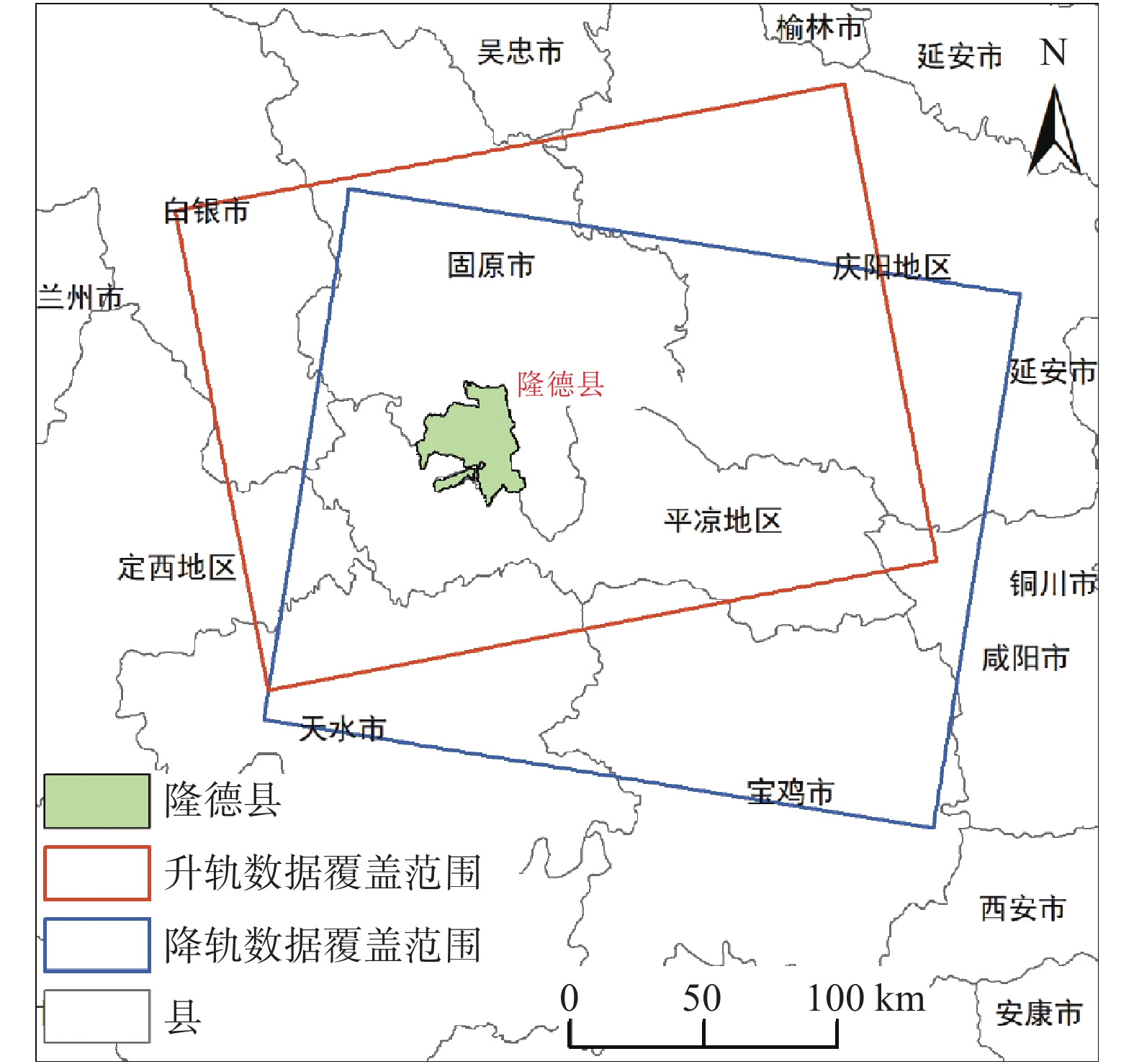
Kuan TU, Wenlong WANG, Hua CHEN, Qiaomin LI, Dan GENG, Chuan WANG, Jian ZHENG, Ying YANG. Early identification of hidden dangers of lanslides based on the combination of ascending and descending orbits InSAR and high spatial resolution optical remote sensing: A case study of landslides in Longde County, southern Ningxia[J]. The Chinese Journal of Geological Hazard and Control, 2021, 32(6): 72-81. DOI: 10.16031/j.cnki.issn.1003-8035.2021.06-09

|
| [1] |
高丽琰, 余江宽, 张幼莹, 等. 基于GIS的层次分析法在宁夏地质灾害易发性评价的应用[J]. 防灾科技学院学报,2017,19(4):8 − 15. [GAO Liyan, YU Jiangkuan, ZHANG Youying, et al. Application of GIS-based analytic hierarchy process in geological hazards assessment in Ningxia region[J]. Journal of Institute of Disaster Prevention,2017,19(4):8 − 15. (in Chinese with English abstract) DOI: 10.3969/j.issn.1673-8047.2017.04.002
|
| [2] |
王成, 孟方, 李天斌. 宁夏回族自治区区域地质志 [R]. 银川: 宁夏回族自治区地质调查院, 2013: 23−30.
WANG Cheng, MENG Fang, LI Tianbin. Regional geology of the Ningxia Hui Autonomous Region [R]. Yinchuan: Geology Survey Institute of Ningxia, 2013: 23−30. (in Chinese)
|
| [3] |
吕世民, 吴凯, 杜光波, 等. 宁夏隆德县地质灾害发育特征及形成条件分析[J]. 水利与建筑工程学报,2015,13(6):42 − 47. [LYU Shimin, WU Kai, DU Guangbo, et al. Development characteristics and formation conditions of geological hazards in Longde County of Ningxia[J]. Journal of Water Resources and Architectural Engineering,2015,13(6):42 − 47. (in Chinese with English abstract) DOI: 10.3969/j.issn.1672-1144.2015.06.008
|
| [4] |
许强, 董秀军, 李为乐. 基于天-空-地一体化的重大地质灾害隐患早期识别与监测预警[J]. 武汉大学学报(信息科学版),2019,44(7):957 − 966. [XU Qiang, DONG Xiujun, LI Weile. Integrated space-air-ground early detection, monitoring and warning system for portential catastrophic geohazards[J]. Geomatics and Information Science of Wuhan University,2019,44(7):957 − 966. (in Chinese with English abstract)
|
| [5] |
许强. 对地质灾害隐患早期识别相关问题的认识与思考[J]. 武汉大学学报(信息科学版),2020,45(11):1651 − 1659. [XU Qiang. Understanding and consideration of related issues in early identification of potential geohazards[J]. Geomatics and Information Science of Wuhan University,2020,45(11):1651 − 1659. (in Chinese with English abstract)
|
| [6] |
葛大庆. 地质灾害早期识别与监测预警中的综合遥感应用[J]. 城市与减灾,2018(6):53 − 60. [GE Daqing. Comprehensive application of remote sensing in early identification, monitoring and early warning in geological disasters[J]. City and Disaster Reduction,2018(6):53 − 60. (in Chinese with English abstract) DOI: 10.3969/j.issn.1671-0495.2018.06.011
|
| [7] |
葛大庆, 戴可人, 郭兆成, 等. 重大地质灾害隐患早期识别中综合遥感应用的思考与建议[J]. 武汉大学学报·信息科学版,2019,44(7):949 − 956. [GE Daqing, DAI Keren, GUO Zhaocheng, et al. Integrated space-air-ground early detection, monitoringand warning system for potential catastrophic geohazards[J]. Geomatics and Information Science of Wuhan University,2019,44(7):949 − 956. (in Chinese with English abstract)
|
| [8] |
葛大庆, 郭兆成. 重大地质灾害隐患早期识别中综合遥感应用的思考[J]. 中国应急救援,2019(1):10 − 14. [GE Daqing, GUO Zhaocheng. Thoughts of early identification of serious geological hazards with integrated remote sensing technologies[J]. China Emergency Rescue,2019(1):10 − 14. (in Chinese with English abstract) DOI: 10.3969/j.issn.1673-5579.2019.01.002
|
| [9] |
ZEBKER H A, ROSEN P A. Atmospheric artifacts in interferometric SAR surface deformation and topographic maps [J]. Department of Electrical Engineering and Geophysics, University of Stanford, Stanford, CA. 1996.
|
| [10] |
FERRETTI A, PRATI C, ROCCA F. Permanent scatterers in SAR interferometry[J]. IEEE Transactions on Geoscience and Remote Sensing,2001,39(1):8 − 20. DOI: 10.1109/36.898661
|
| [11] |
COLESANTI C, FERRETTI A, NOVALI F, et al. SAR monitoring of progressive and seasonal ground deformation using the permanent scatterers technique[J]. IEEE Transactions on Geoscience and Remote Sensing,2003,41(7):1685 − 1701. DOI: 10.1109/TGRS.2003.813278
|
| [12] |
FERRETTI A, PRATI C, ROCCA F. Nonlinear subsidence rate estimation using permanent scatterers in differential SAR interferometry[J]. IEEE Transactions on Geoscience and Remote Sensing,2000,38(5):2202 − 2212. DOI: 10.1109/36.868878
|
| [13] |
LANARI R, MORA O, MANUNTA M, et al. A small-baseline approach for investigating deformations on full-resolution differential SAR interferograms[J]. IEEE Transactions on Geoscience and Remote Sensing,2004,42(7):1377 − 1386. DOI: 10.1109/TGRS.2004.828196
|
| [14] |
WERNER C, WEGMULLER U, STROZZI T, et al. Interferometric point target analysis for deformation mapping[C]//IGARSS 2003.2003 IEEE International Geoscience and Remote Sensing Symposium. Proceedings (IEEE Cat. No. 03CH37477). July 21−25, 2003, Toulouse, France. IEEE, 2003: 4362−4364.
|
| [15] |
FERRETTI A, FUMAGALLI A, NOVALI F, et al. A new algorithm for processing interferometric data-stacks: SqueeSAR[J]. IEEE Transactions on Geoscience and Remote Sensing,2011,49(9):3460 − 3470. DOI: 10.1109/TGRS.2011.2124465
|
| [16] |
李振洪, 宋闯, 余琛, 等. 卫星雷达遥感在滑坡灾害探测和监测中的应用: 挑战与对策[J]. 武汉大学学报(信息科学版),2019,44(7):967 − 979. [LI Zhenhong, SONG Chuang, YU Chen, et al. Application of satellite remote sensing to landslide detection and mornitoring: Challenges and solutions[J]. Geomatics and Information Science of Wuhan University,2019,44(7):967 − 979. (in Chinese with English abstract)
|
| [17] |
FRUNEAU B, ACHACHE J, DELACOURT C. Observation and modelling of the Saint-Étienne-de-Tinée landslide using SAR interferometry[J]. Tectonophysics,1996,265(3/4):181 − 190.
|
| [18] |
RAUCOULES D, MAISONS C, CARNEC C, et al. Monitoring of slow ground deformation by ERS radar interferometry on the Vauvert salt mine (France)[J]. Remote Sensing of Environment,2003,88(4):468 − 478. DOI: 10.1016/j.rse.2003.09.005
|
| [19] |
王绚, 范宣梅, 杨帆, 等. 植被茂密山区地质灾害遥感解译方法研究[J]. 武汉大学学报(信息科学版),2020,45(11):1771 − 1781. [WANG Xuan, FAN Xuanmei, YANG Fan, et al. Remote sensing interpretation method of geological hazards in lush mountainous area[J]. Geomatics and Information Science of Wuhan University,2020,45(11):1771 − 1781. (in Chinese with English abstract)
|
| [20] |
张幼莹, 余江宽, 步凡, 等. “高分二号”卫星在黄土地质灾害解译中的应用研究[J]. 测绘与空间地理信息,2017,40(11):31 − 34. [ZHANG Youying, YU Jiangkuan, BU Fan, et al. Application of GF-2Satellite to geological hazard interpretation in loess plateau[J]. Geomatics & Spatial Information Technology,2017,40(11):31 − 34. (in Chinese with English abstract) DOI: 10.3969/j.issn.1672-5867.2017.11.009
|
| [21] |
彭令, 徐素宁, 梅军军, 等. 地震滑坡高分辨率遥感影像识别[J]. 遥感学报,2017,21(4):509 − 518. [PENG Ling, XU Suning, MEI Junjun, et al. Earthquake-induced landslide recognition using high-resolution remote sensing images[J]. Journal of Remote Sensing,2017,21(4):509 − 518. (in Chinese with English abstract)
|
| [22] |
陆会燕, 李为乐, 许强, 等. 光学遥感与InSAR结合的金沙江白格滑坡上下游滑坡隐患早期识别[J]. 武汉大学学报(信息科学版),2019,44(9):1342 − 1354. [LU Huiyan, LI Weile, XU Qiang, et al. Early detection of landslides in the upstream and downstream areas of the Baige landslide, the Jinsha River based on optical remote sensing and InSAR technologies[J]. Geomatics and Information Science of Wuhan University,2019,44(9):1342 − 1354. (in Chinese with English abstract)
|
| [23] |
CARLÀ T, INTRIERI E, RASPINI F, et al. Perspectives on the prediction of catastrophic slope failures from satellite InSAR[J]. Scientific Reports,2019,9:14137. DOI: 10.1038/s41598-019-50792-y
|
| [24] |
DIAO X P, WU K, HU D H, et al. Combining differential SAR interferometry and the probability integral method for three-dimensional deformation monitoring of mining areas[J]. International Journal of Remote Sensing,2016,37(21):5196 − 5212. DOI: 10.1080/01431161.2016.1230284
|
| [25] |
刘星洪, 姚鑫, 周振凯, 等. 滑坡灾害InSAR应急排查技术方法研究[J]. 地质力学学报,2018,24(2):229 − 237. [LIU Xinghong, YAO Xin, ZHOU Zhenkai, et al. Study of the technique for landslide rapid recognition by InSAR[J]. Journal of Geomechanics,2018,24(2):229 − 237. (in Chinese with English abstract) DOI: 10.12090/j.issn.1006-6616.2018.24.02.024
|
| [26] |
HU J, LI Z W, DING X L, et al. Resolving three-dimensional surface displacements from InSAR measurements: a review[J]. Earth-Science Reviews,2014,133:1 − 17. DOI: 10.1016/j.earscirev.2014.02.005
|
| [27] |
HU X, WANG T, PIERSON T C, et al. Detecting seasonal landslide movement within the Cascade landslide complex (Washington) using time-series SAR imagery[J]. Remote Sensing of Environment,2016,187:49 − 61. DOI: 10.1016/j.rse.2016.10.006
|
| [28] |
ERIKSEN H Ø, LAUKNES T R, LARSEN Y, et al. Visualizing and interpreting surface displacement patterns on unstable slopes using multi-geometry satellite SAR interferometry (2D InSAR)[J]. Remote Sensing of Environment,2017,191:297 − 312. DOI: 10.1016/j.rse.2016.12.024
|
| [29] |
PRICE E J, SANDWELL D T. Small-scale deformations associated with the 1992 Landers, California, earthquake mapped by synthetic aperture radar interferometry phase gradients[J]. Journal of Geophysical Research:Solid Earth,1998,103(B11):27001 − 27016. DOI: 10.1029/98JB01821
|
| [30] |
STROZZI T, WEGMULLER U, WERNER C, et al. Measurement of slow uniform surface displacement with mm/year accuracy[C]//IGARSS 2000. IEEE 2000 International Geoscience and Remote Sensing Symposium. Taking the Pulse of the Planet: The Role of Remote Sensing in Managing the Environment. Proceedings (Cat. No. 00CH37120). July 24-28, 2000, Honolulu, HI, USA. IEEE, 2000: 2239-2241.
|
| [31] |
彭令, 徐素宁, 梅军军, 等. 资源三号卫星在汶川震区滑坡快速识别中的应用方法研究[J]. 遥感技术与应用,2018,33(1):185 − 192. [PENG Ling, XU Suning, MEI Junjun, et al. Research on Wenchuan earthquake-induced landslides rapid recognition from ZY-3 imagery[J]. Remote Sensing Technology and Application,2018,33(1):185 − 192. (in Chinese with English abstract)
|
| [32] |
CASCINI L, FORNARO G, PEDUTO D. Advanced low- and full-resolution DInSAR map generation for slow-moving landslide analysis at different scales[J]. Engineering Geology,2010,112(1/2/3/4):29 − 42.
|
| [33] |
董文, 潘建平, 阳振宇, 等. 高分二号卫星数据在地质灾害调查中的应用: 以重庆万州区为例[J]. 中国地质灾害与防治学报,2019,30(1):106 − 111. [DONG Wen, PAN Jianping, YANG Zhenyu, et al. Application of GF-2 satellite data in geological hazard survey: A case study in Wanzhou district of Chongqing City[J]. The Chinese Journal of Geological Hazard and Control,2019,30(1):106 − 111. (in Chinese with English abstract)
|
| [34] |
潘腾. 高分二号卫星的技术特点[J]. 中国航天,2015(1):3 − 9. [PAN Teng. The technology characteristics of Gaofen-2 satellite[J]. Aerospace China,2015(1):3 − 9. (in Chinese with English abstract)
|
| [35] |
王智勇, 文强, 李晶晶, 等. 从开拓到引领: 赋能国内商业遥感卫星运行服务[J]. 中国测绘,2019(10):28 − 30. [WANG Zhiyong, WEN Qiang, LI Jingjing, et al. From pioneering to leading: Enabling domestic commercial remote sensing satellite operation services[J]. China Surveying and Mapping,2019(10):28 − 30. (in Chinese with English abstract) DOI: 10.3969/j.issn.1005-6831.2019.10.008
|
| [36] |
ZHANG Y, MENG X M, JORDAN C, et al. Investigating slow-moving landslides in the Zhouqu region of China using InSAR time series[J]. Landslides,2018,15(7):1299 − 1315. DOI: 10.1007/s10346-018-0954-8
|
| [1] | Jinjin JIANG, Jia LIU, Shan JIANG, Fengshun ZHAO, Bo LAI. Research on Multivariate Regression LSTM Model for Predicting Soft Soil Ground Settlement in Zhuhai City[J]. The Chinese Journal of Geological Hazard and Control. DOI: 10.16031/j.cnki.issn.1003-8035.202410009 |
| [2] | Yu FENG, Huaien ZENG, Pengfei TU. Research on prediction model of landslide creep displacement on genetic algorithm[J]. The Chinese Journal of Geological Hazard and Control, 2024, 35(1): 82-91. DOI: 10.16031/j.cnki.issn.1003-8035.202209038 |
| [3] | Yongtang YU, Jianguo ZHENG, Mo SUN, Xin HUANG, Wenbin HAN. Evaluation methods for performance of post-construction settlement prediction models in thick loess filled ground[J]. The Chinese Journal of Geological Hazard and Control, 2023, 34(4): 39-48. DOI: 10.16031/j.cnki.issn.1003-8035.202211003 |
| [4] | Lei ZHANG, Yinpeng ZHOU, Yu ZHUANG, Aiguo XING, Junyi HE, Yanbo ZHANG. Dynamic analysis and prediction of rear slope affected area of the Jianshanying landslide in Shuicheng County, Guizhou Province[J]. The Chinese Journal of Geological Hazard and Control, 2023, 34(3): 1-7. DOI: 10.16031/j.cnki.issn.1003-8035.202204006 |
| [5] | Yusi YUAN, Xiaopeng FENG, Yong LI, Cancan YI. Prediction of mine slope deformation based on PSO-DSRVM[J]. The Chinese Journal of Geological Hazard and Control, 2023, 34(1): 1-7. DOI: 10.16031/j.cnki.issn.1003-8035.202112032 |
| [6] | Suhua ZHOU, Shuaikang ZHOU, Yunqiang ZHANG, Zhihong NIE, Yu LEI. Predicting of swelling-shrinking level of expansive soil using support vector regression[J]. The Chinese Journal of Geological Hazard and Control, 2021, 32(1): 117-126. DOI: 10.16031/j.cnki.issn.1003-8035.2021.01.16 |
| [7] | Jianping CHEN, Chunlei WANG, Xuedong WANG. Coal mine floor water inrush prediction based on CNN neural network[J]. The Chinese Journal of Geological Hazard and Control, 2021, 32(1): 50-57. DOI: 10.16031/j.cnki.issn.1003-8035.2021.01.07 |
| [8] | ZHAI Shuhua, MAO Jian, NAN Yun, LIU Huanhuan, WANG Yuntao, WANG Qiangqiang, XIONG Chunhua, WANG Yanmei. Multi-factors fusion method of debris flow prediction based on genetic programming[J]. The Chinese Journal of Geological Hazard and Control, 2020, 31(6): 111-115. DOI: 10.16031/j.cnki.issn.1003-8035.2020.06.14 |
| [9] | WU Bo, ZHAO Fasuo, HE Ziguang, DUAN Zhao, WU Shaoyan. Prediction of the disaster area of loess landslide based on least square support vector machine optimized by bat algorithm[J]. The Chinese Journal of Geological Hazard and Control, 2020, 31(5): 1-6. DOI: 10.16031/j.cnki.issn.1003-8035.2020.05.01 |
| 1. |
杨皓铭,黄强兵,解庆禹,崔磊,康孝森,王作辰. 饱和压实黄土的Duncan-Chang损伤本构模型研究. 水文地质工程地质. 2025(03): 79-90 .

| |
| 2. |
侯小强,周重任,吴红刚,胡天翔,侯云龙. 间歇性降雨作用下牵引式滑坡的时空演化分析和失稳判据研究. 清华大学学报(自然科学版). 2024(08): 1347-1356 .
| |
| 3. |
王宝成,罗崇亮,魏书宝,刘伟,靳伟,张鹏. 石灰改良陇东黄土静、动模量及其影响因素试验研究. 公路. 2024(11): 54-60 .
| |
| 4. |
张丽娜,李萍,胡向阳,钟建平,杨恺,赵枝艳,李同录. 不同坡度和植被覆盖黄土对降雨入渗的响应规律. 水土保持学报. 2024(06): 113-121 .
| |
| 5. |
王子,王栋,姜帅,李艳军,安培源. 西气东输管道工程陕西岭湾村滑坡变形特征及成因机制分析. 中国地质灾害与防治学报. 2023(03): 8-19 .
本站查看
| |
| 6. |
刘亚斌,梁燊,石川,王舒,胡夏嵩,李国荣,朱海丽. 青藏高原东北部黄土区柠条锦鸡儿根系的锚固效应. 中国地质灾害与防治学报. 2023(05): 107-116 .
本站查看
| |
| 7. |
李同录,袁思凡,徐家隆,胡向阳,李萍. 降雨引起的两类不同浅层滑坡稳定性的计算模型——与“浅层黄土滑坡易发性评价:以晋西黄土区蔡家川农地小流域为例”一文商榷. 山地学报. 2023(06): 916-925 .
|

 Email alert
 RSS
RSS DownLoad: