

Susceptibility evaluation of valley debris flow based on dual-channel network with fusion attention mechanism
-
摘要:
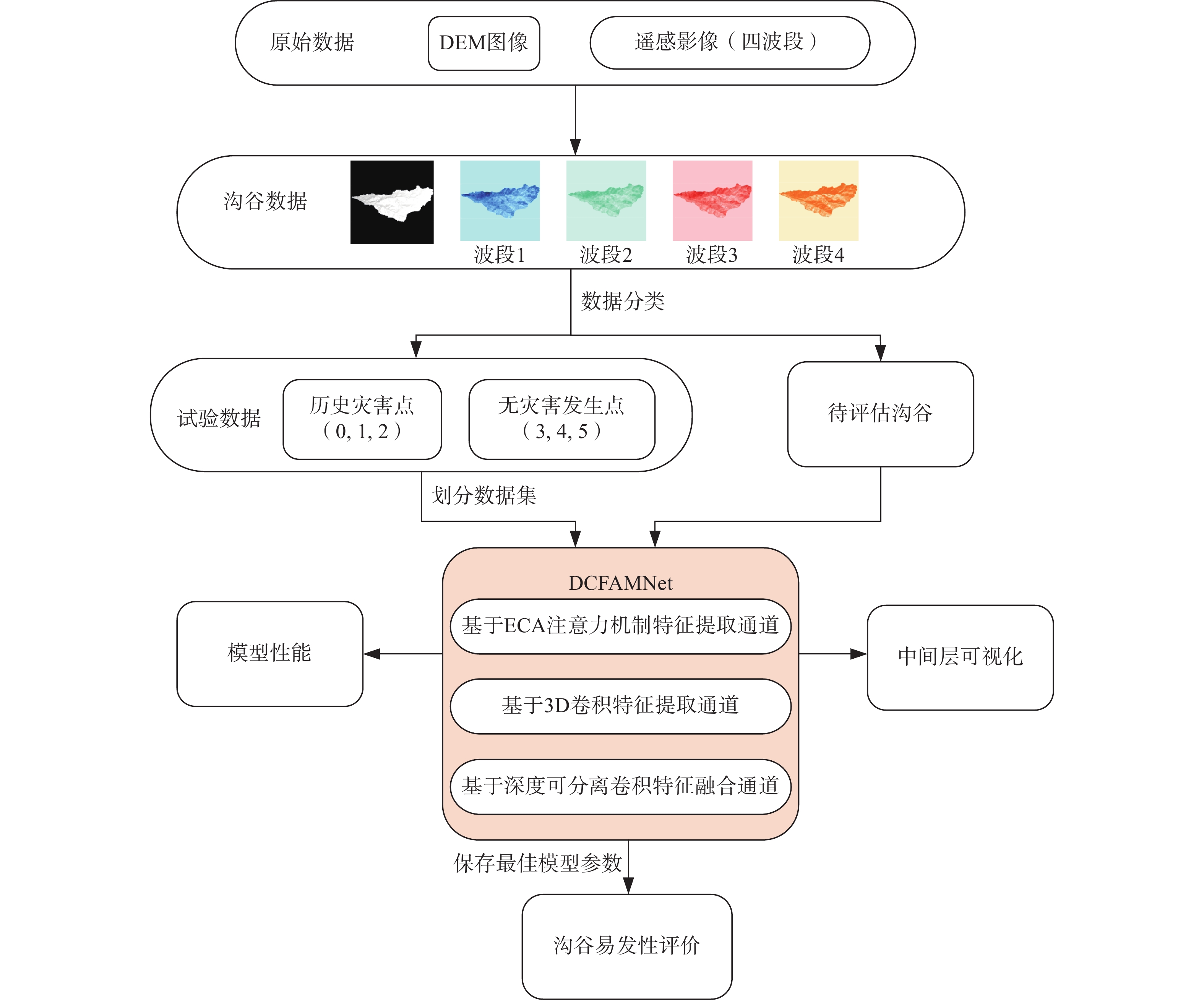
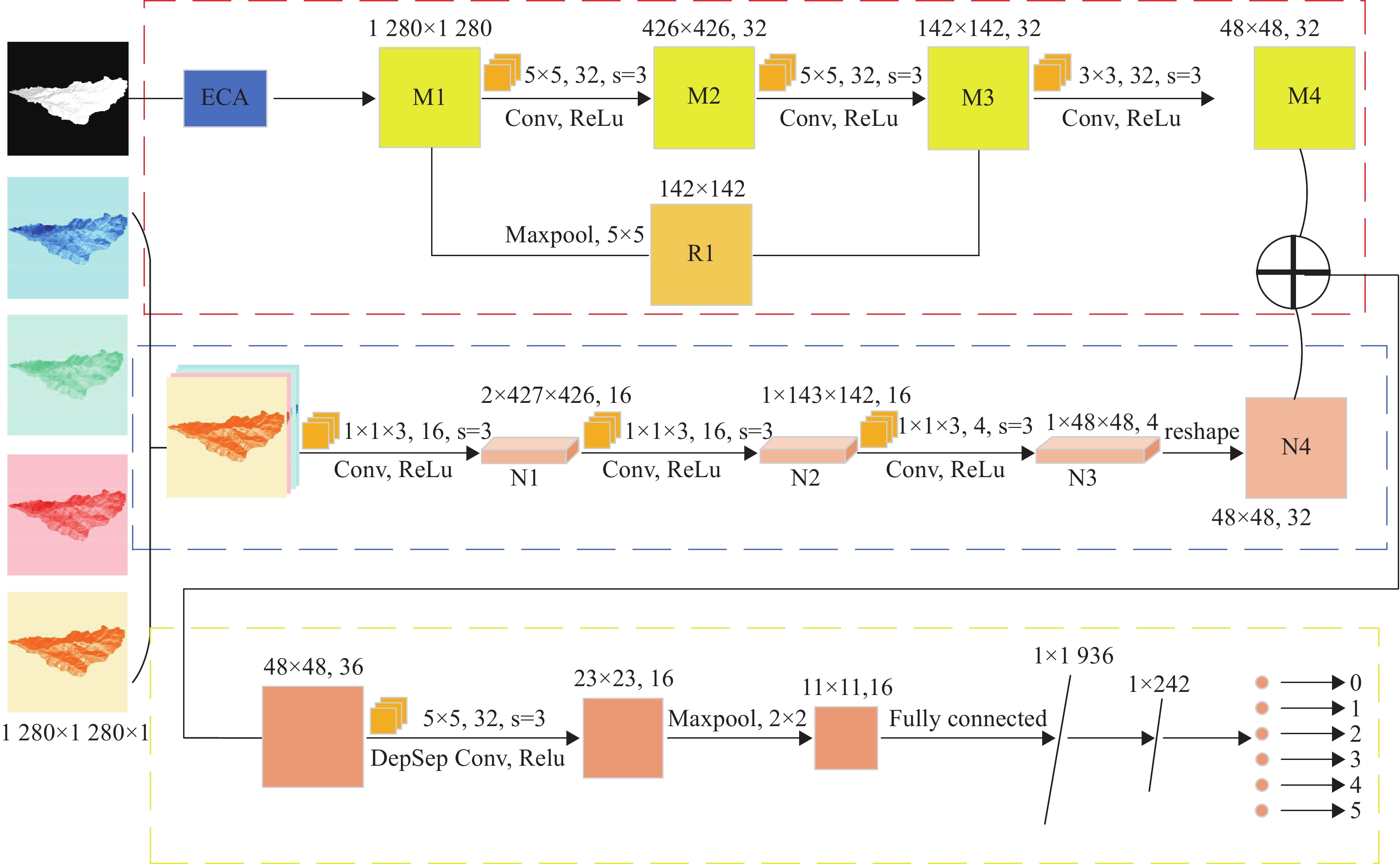
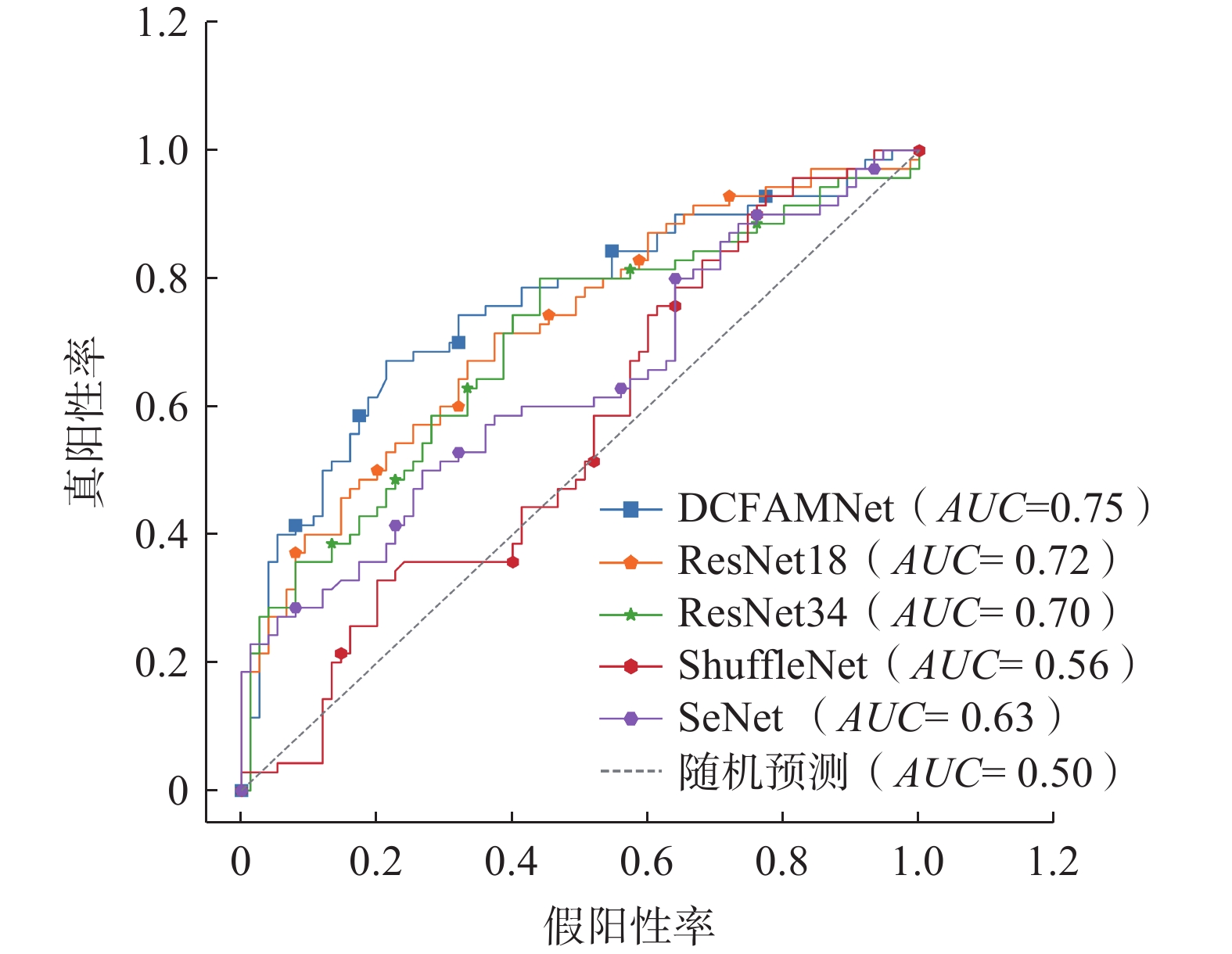
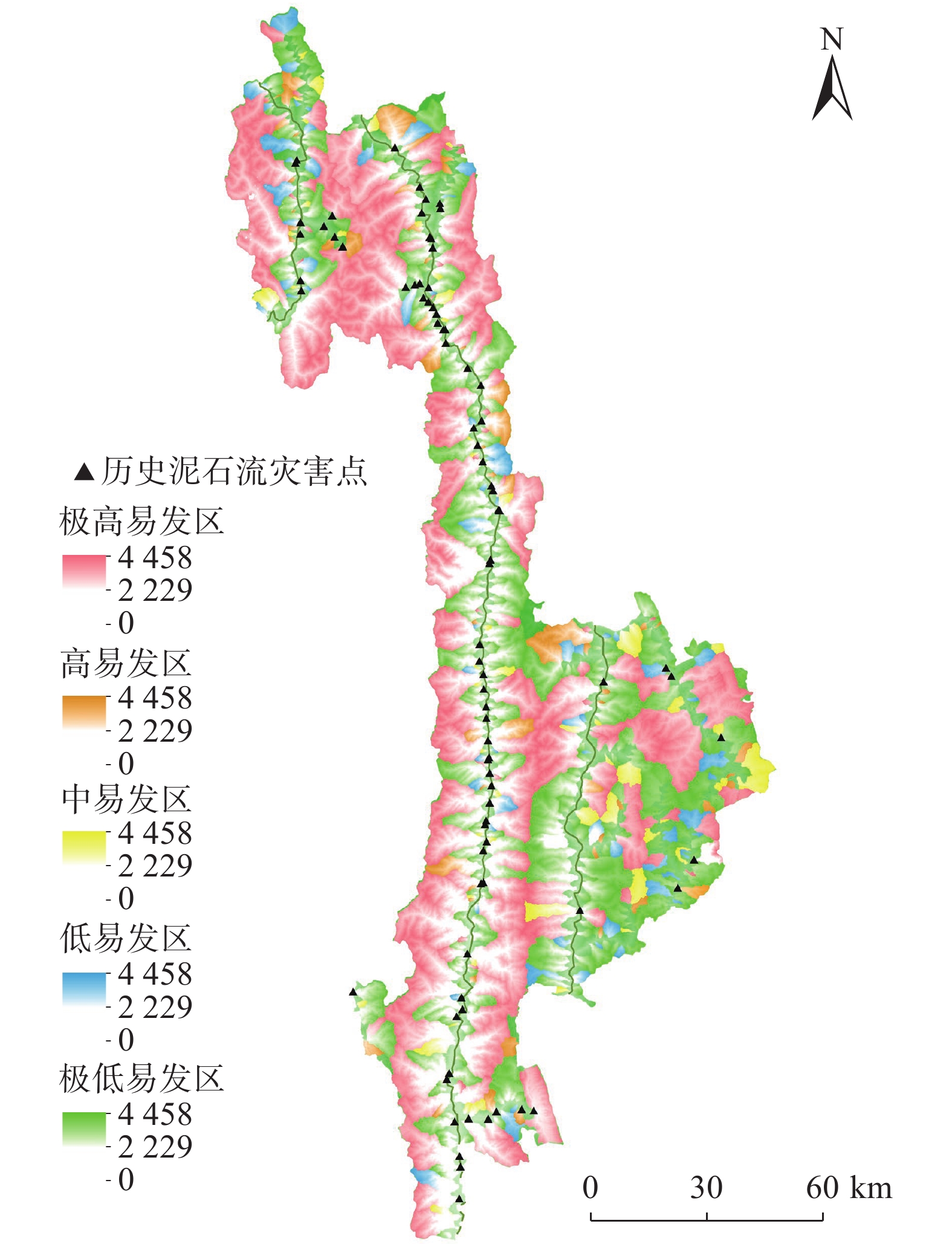
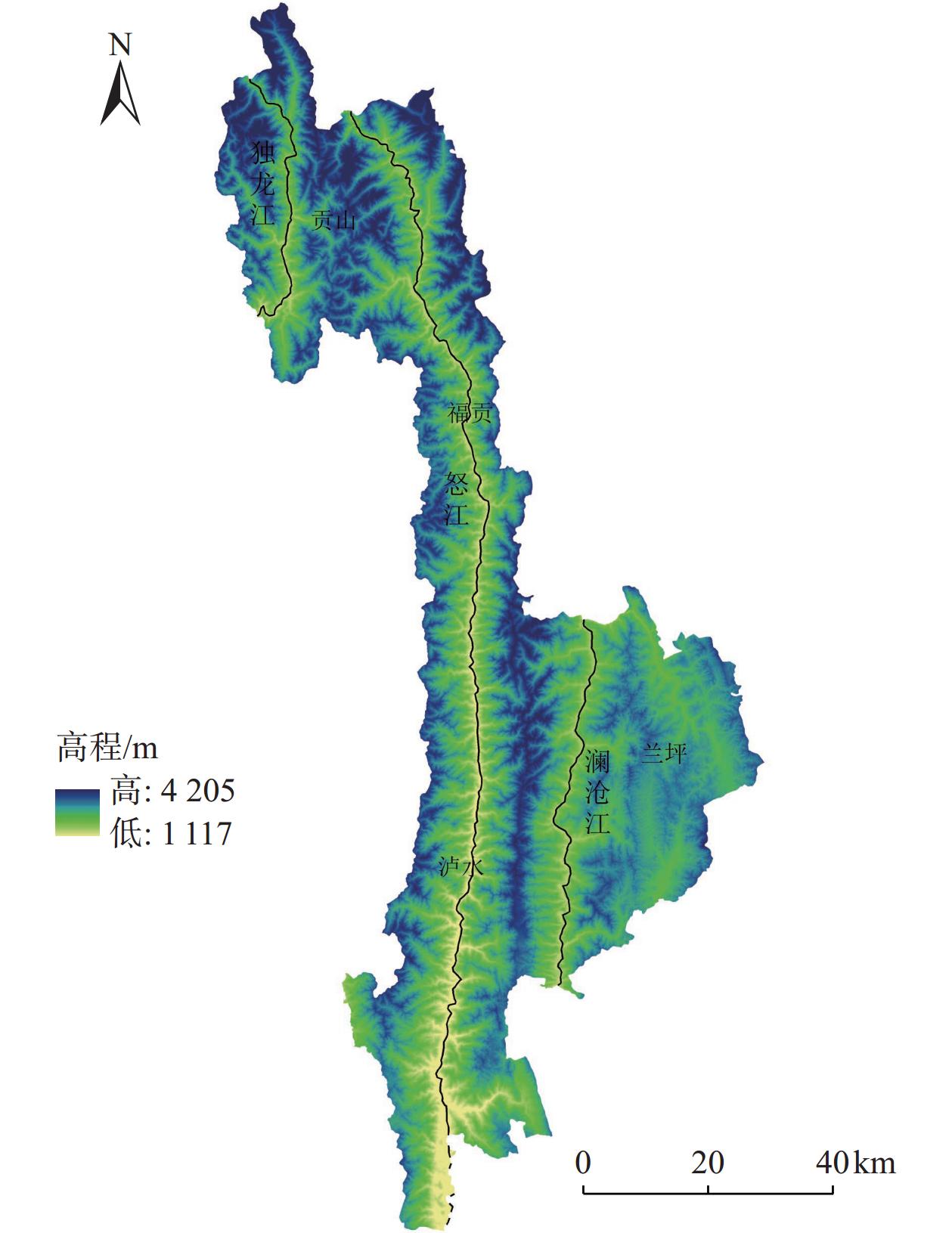
针对泥石流灾害评估问题,文章提出了一种新的轻量化卷积神经网络模型——融合注意力机制的双通道网络(dual-channel fusion attention mechanism network,DCFAMNet),旨在快速识别沟谷型泥石流灾害。首先,根据历史泥石流点记录,以沟谷数字高程图像(digital elevation map,DEM)及遥感影像为数据源,设计以双通道网络结构为基础技术框架,在DEM图像特征提取通道引入通道注意力机制强调图像特征的网络通道权重,在遥感影像特征通道引入3D卷积块提取沟谷的地表信息,在特征融合阶段利用深度可分离卷积进行更多的特征信息交互。其次,对相关流域的潜在威胁沟谷作出易发性预测,绘制泥石流灾害易发性图。最后,可视化DCFAMNet提取到的沟谷坡向、曲率、坡度等深层特征定位目标关键特征。结果表明,利用DCFAMNet结合GIS技术对泥石流沟谷的识别率可达到80%,AUC值为0.75,表现良好。保存模型最佳参数评估相关沟谷易发性,通过ArcGIS做可视化分析将泥石流灾害分为5个评价等级,并确定泥石流极高易发性,得出高易发区主要分布在贡山县独龙江干流、福贡县怒江干流等水系区域,兰坪县相对较安全。结果可为山区泥石流防灾减灾工作提供有用的参考和依据。
Abstract:In addressing the issue of debris flow disaster assessment, this paper proposes a novel lightweight convolutional neural network model, the Dual-Channel Fusion Attention Mechanism Network (DCFAMNet), designed to rapidly identifying the susceptibility of gully-type debris flows. The main contributions of this paper are as follows: Firstly, based on historical debris flow records and using Digital Elevation Maps (DEMs) and remote sensing images as data sources, a dual-channel network structure is designed as the basic technical framework. Within the DEM image feature extraction channel, a channel attention mechanism is introduced to emphasize the channel weights of the image features, while in the remote sensing image feature extraction channel, 3D convolutional blocks are employed to extract the surface information of the gullies. In the feature fusion stage, depthwise separable convolutions are used to facilitate more interaction of feature information. Secondly, the susceptibility prediction of potential threats gullies in the related basins is made, and susceptibility maps of debris flow disasters are generated. Finally, DCFAMNet visualizes the extracted deep features such as gully slope, curvature, and slope orientation. Experimental results indicate that, by integrating the DCFAMNet with GIS technology, the identification rate for debris flow gullies can reach up to 80%, with an AUC value of 0.75, indicating good performance. The best parameters of the model are retained for assessing the susceptbility scores of the relevant gullies. Through visualization analysis in ArcGIS, the debris flow disaster risk is categorized into five assessment levels. It is determined that the extremely high susceptibility and high susceptibility zones for debris flows are primarily distributed in the mainstream of the Dulong River in Gongshan County and the mainstream of the Nujiang River in Fugong County, while Lanping County is relatively safe. The findings of this research can provide valuable insights and foundations for the prevention and mitigation of debris flow disasters in mountainous regions.
-
0. 引言
黄土是第四纪以来形成的一种多孔隙弱胶结构的特殊沉积物,具有大孔隙、水敏性、力学性质差和节理裂隙发育的特点[1]。由于黄土的特殊性质,黄土滑坡是我国发生数量最多、危害最严重的突发性地质灾害之一。
甘肃省是我国黄土滑坡地质灾害发生频繁的省份之一[2],黄土滑坡常造成群死群伤和重大财产损失并影响社会安全稳定。1983年3月7日,甘肃省东乡县洒勒山高速滑坡,造成220人死亡,成为我国最严重的灾难性黄土滑坡之一。黄土滑坡研究一直是国内外的热点,EDWARD等[3]对中国西北部黄土滑坡进行了初步研究和部分模型构建;彭建兵院士等[4 − 6]对黄土高原滑坡的空间分布发育特征、形成机制等进行了全面系统的研究,同时总结了区域构造及典型人类工程活动对黄土滑坡的影响;吴玮江等[7 − 8]、冉林等[9]通过对甘肃黄土滑坡研究,总结了黄土地区滑坡的分布规律,主要的四种类型及各类滑坡的活动特征;张茂省等[10 − 11]对黄土滑坡诱发因素及其形成机理开展了相关研究,得出降水和人类工程活动是最积极的诱发因素;刘琨[12]、李同录等[13]、王民兰等[14]对降雨及地震引发滑坡进行了专门研究,得出了降雨及地震情况下黄土滑坡的形成机制。
由于人类工程活动的强度和规模的不断增加,由其引发的滑坡灾害也不断增多,常造成严重的经济损失和人员伤亡,增大工程投资,拖延工期,严重影响工程建设的顺利进行。本文以甘肃平凉地区静宁县田堡调蓄水池滑坡为研究对象,在现场调查、勘探、无人机测量及滑坡滑动前勘查资料的基础上,对滑坡成因及稳定性进行了系统研究,以期对同类滑坡的研究提供参考。
1. 工程地质环境概况
1.1 滑坡区位置及概况
研究区位于甘肃省平凉市静宁县四河镇席家河左岸斜坡地带,为引洮供水二期工程覆盖地区(图1)。
区内工程建设主要为田堡30×104 m3调蓄水池,主要功能是解决引洮供水工程检修期间静宁县西部10个乡镇人民的生活用水问题。工程于2020年3月20日开工建设,工程建设主要内容有坝基和北岸边坡开挖、临河侧填筑等,2020年9月18日,调蓄水池左岸发生滑坡,滑坡破坏已开挖的边坡和公路路基,严重威胁田堡调蓄水池的正常建设。
1.2 地形地貌
静宁县地处陇西黄土高原东部,属黄土低中山梁峁地貌区。滑坡区地貌主要是厚黄土覆盖于波状起伏的新近系红层上的黄土丘陵。由于强烈侵蚀、切割,区内沟壑纵横、地形起伏。海拔在1600~2245 m,相对高差一般为200~300 m,平均坡度15°~30°。在沟底和部分谷坡可见新近系地层出露,沟岸滑坡、崩塌较为发育。
1.3 地层岩性
本区地层结构较为简单,基底地层主要是巨厚的新近系砖红色泥岩夹灰白色砂岩(N),产状近于水平,岩性软弱,分布广泛,在部分冲沟中下部有出露。黄土梁区广泛披覆马兰黄土(
1.4 水文地质条件
静宁县属于温带干旱、半干旱气候区,多年平均降水量453.3 mm,多年平均蒸发量1 512 mm,为降水量的3.37倍。由于降水稀少蒸发强烈,再加上地形起伏,地下水补给条件差,斜坡区地下水总体贫乏,只在汇水条件较好的地势低洼部位有少量黄土潜水。
2. 滑坡特征
2.1 形态特征
滑坡位于席家河北岸斜坡地带,平面形态呈不规则四边形(图2),南北平均长180 m,东西宽240 m,面积4.32×10⁴ m2,滑体厚3.0~18.0 m,平均11.2 m,体积48.5×10⁴ m3,滑坡主滑方向191°(图3)。滑坡后缘高程1 900~1 908 m,东侧前缘高程1 842 m,西侧高程1 850 m左右,前后缘高差约58 m,平均坡度15.8°。
![]() 图 3 滑坡勘查平面图1—滑坡周界 ;2—拉张裂缝;3—鼓胀裂缝;4—扇状裂缝;5—剪张裂缝; 6—滑坡洼地Figure 3. Plan view of the landslide investigation
图 3 滑坡勘查平面图1—滑坡周界 ;2—拉张裂缝;3—鼓胀裂缝;4—扇状裂缝;5—剪张裂缝; 6—滑坡洼地Figure 3. Plan view of the landslide investigation受南北向分布的小冲沟等地形影响,滑坡后壁形态很不规则。实际上,该滑坡后壁是由4~5个相对独立的次级滑坡的后壁组合而成,高度3~6 m,坡度50°~60°,其上擦痕较为清晰。
剖面上滑坡总体呈多级台阶状(图4)。最上部为后壁滑落形成的高度12 m左右、坡度约25°的堆积坡体,其下部为宽20~40 m的平台,东西两侧较宽,中间窄,分布高程1 882~1 888 m。中部为宽大的滑坡主平台,宽40~75 m,分布高程1 866~1 878 m,整体略为反坡,中部发育长100 m、宽15~30 m、深约3 m的洼地。主平台前部为人工开挖形成的高10~15 m、坡度35°~45°的陡坡。滑坡前缘东侧为长约100 m、宽30~40 m、坡度16°左右的滑舌,已伸入拟建库区,分布高程1 842~1 854 m。
![]() 图 4 滑坡地质剖面图1—滑坡堆积; 2—粉质黏土;3—马兰黄土 ;4—泥岩 ;5—砂岩;6—滑动面 ;7—钻孔Figure 4. Geological cross-section of the landslide
图 4 滑坡地质剖面图1—滑坡堆积; 2—粉质黏土;3—马兰黄土 ;4—泥岩 ;5—砂岩;6—滑动面 ;7—钻孔Figure 4. Geological cross-section of the landslide滑坡西侧前部发育H1次级滑坡,平面形态呈簸箕状,南北长75 m、东西宽50~80 m,体积约5×10⁴ m3,主滑方向200°。H1次级滑坡实际上是2020年5月中旬已滑动的部分, 9月整体滑坡时为相对独立且滑动剧烈的块体,地势相对低洼,其后部范围有所扩大。
2.2 结构特征
蓄水池滑坡的滑体主要为原老滑坡体物质,岩性为滑动后的红层和黄土,结构相对完整,层序扰动轻微,滑体表部主要为黄土,厚3.0~6.7 m,中部主平台一带厚度较大且连续分布;以下滑体主要为红层(图5)。滑坡后壁主要由红层组成。前缘滑体岩土成分与结构相对混杂,夹有较多席家河冲洪积形成的青灰色粉质黏土。
该滑坡是老滑坡的大规模复活滑动,滑动面基本继承了老动滑面(图6),后部滑动面倾角45°、中部20°~11°、前部6°左右,滑带土主要是棕红色粉质黏土,稍湿-湿,可塑-软塑状,局部可见滑动擦痕和光亮面,滑床为新近系红层。后部滑体厚度3~9 m,中部8~18 m,前部厚度3~12 m,平均厚度11.2 m,属于中层中型滑坡。
2.3 变形滑移特征
滑坡体上各种裂缝非常发育,滑坡后部对应各次级滑坡后壁发育拉张裂缝、侧缘剪切裂缝和鼓胀裂缝。滑坡中部主平台区东侧前部发育鼓胀裂缝,走向与滑动方向垂直,规模较大,裂缝前部滑体普遍鼓起2 m左右,表现出前部滑体受后部滑体的强烈推挤而鼓起。滑坡东侧剪张裂缝发育,道路、护坡被剪断;H1次级滑坡东侧边界一带剪张裂缝及后部拉张裂缝较为发育。滑坡东侧前缘剪出口向南突出,伸入河谷区已开挖的场地内,较西侧剪出口前移30 m左右,滑坡剪出口一带连续鼓起1 m左右,鼓胀裂缝和放射状裂缝普遍发育(图7)。
![]() 图 7 滑坡东侧前缘鼓胀裂缝Figure 7. Front shear outlet and bulging cracks on the east side of landslide
图 7 滑坡东侧前缘鼓胀裂缝Figure 7. Front shear outlet and bulging cracks on the east side of landslide通过现场调查和正射影像分析,蓄水池滑坡的滑动具有一定差异性,后缘部位的滑距较大,一般水平滑距为6~9 m,下错3~5 m;前缘水平滑距多为1~3 m,东侧大部分拱起1~2 m。H1滑坡是前缘滑动相对剧烈的部位。
3. 滑坡成因分析
静宁县田堡调蓄水池滑坡的成因包括内在的地质环境条件和外部引发因素两方面。老滑坡的存在是地质基础,大规模的前缘开挖和大量而集中的降水共同引发了复活滑动。
3.1 老滑坡是本次滑坡的地质基础
静宁县是我省滑坡发育的县份之一,据调查,近东西向展布的席家河河谷北岸斜坡较陡,坡度20°~25°,老滑坡较为发育。田堡调蓄水池北侧老滑坡发育,其主要证据有斜坡区圈椅状滑坡地形明显、地形零乱(图8),前缘发育混杂的滑坡堆积体和滑动面,并根据水库下游200 m席家河北岸15 m高的Ⅱ级阶地前缘堆积物中夹有混杂滑体(图9),可以确定老滑坡形成时代为早全新世。可见,老滑坡三方面的特征要素齐全。老滑坡破坏了斜坡地质结构和稳定性,其滑动面是后期进一步复活滑动的有利结构面。
![]() 图 8 蓄水池北侧老滑坡影像图Figure 8. Aerial view of the old landslide on the north side of the reservoir
图 8 蓄水池北侧老滑坡影像图Figure 8. Aerial view of the old landslide on the north side of the reservoir![]() 图 9 老滑坡前缘滑体与Ⅱ阶地关系图1—滑坡堆积; 2—粉质黏土;3—泥岩; 4—滑动面Figure 9. Relationship between the front sliding body of the old landslide and the second terrace
图 9 老滑坡前缘滑体与Ⅱ阶地关系图1—滑坡堆积; 2—粉质黏土;3—泥岩; 4—滑动面Figure 9. Relationship between the front sliding body of the old landslide and the second terrace3.2 前缘工程开挖
由于席家河河谷狭窄,调蓄水池建设场地空间有限,因此,工程建设主要对北侧老滑坡前部进行了大量开挖(图10)。开挖宽度50~60 m,平均深度8 m左右,即老滑坡前部每延米的平均开挖量约450 m3/m,总开挖量1.08×105 m3,占老滑坡总体积的15%左右(图11),大幅降低了老滑坡前部的抗滑能力和稳定性。就斜坡区坡脚开挖和坡顶加载相对而言,坡脚开挖更容易改变斜坡应力分布,降低斜坡稳定性和引发滑坡。因此,前部工程开挖是引发本次老滑坡复活滑动的主要原因。
![]() 图 10 蓄水池工程开挖老滑坡前缘Figure 10. Excavation of the front edge of the old landslide in the reservoir project
图 10 蓄水池工程开挖老滑坡前缘Figure 10. Excavation of the front edge of the old landslide in the reservoir project![]() 图 11 蓄水池工程开挖断面图1—滑坡堆积物 ;2—粉质黏土; 3—泥岩 ;4—砂岩 ;5—原设调蓄水池计开挖线Figure 11. Cross-sectional view of the excavation at reservoir project
图 11 蓄水池工程开挖断面图1—滑坡堆积物 ;2—粉质黏土; 3—泥岩 ;4—砂岩 ;5—原设调蓄水池计开挖线Figure 11. Cross-sectional view of the excavation at reservoir project3.3 降水的不利影响
根据气象资料,静宁县2018—2020年连续三年为丰水年,降水量分别达518.9 mm、578.9 mm和647 mm,为多年平均降水量的114.5%~142.7%。降水集中且多为暴雨形式,2018年7—9月降水量占全年的58.5%,每月的降水量均在100 mm以上。特别是2020年的降水更加集中在5、6、8三个月内,均在月平均降水量的一倍以上(图12)。6月份降水166.5 mm,其中6月25—26日降水达142.2 mm;8月份降水达188.8 mm。大量降水沿落水洞、裂缝下渗至坡体内,软化土体,导致调蓄水池工程施工过程中于9月18日老滑坡发生复活滑动。
![]() 图 12 静宁县2020年与多年平均逐月降水量曲线图Figure 12. Curves of 2020 and multi-year average monthly precipitation in Jingning County
图 12 静宁县2020年与多年平均逐月降水量曲线图Figure 12. Curves of 2020 and multi-year average monthly precipitation in Jingning County3.4 滑坡破坏变形机制分析
由上述可知,蓄水池北侧老滑坡复活滑动的主要原因是工程开挖降低滑体前部的抗滑力,很自然的认为该滑坡属于前部首先失稳滑动,再牵引后部滑动的牵引式滑坡。但从滑坡后部的滑距明显较前部大、前缘拱起,且主平台区东侧前部鼓胀裂缝侧前部滑体普遍鼓起2m左右的实际情况,该滑坡表现出前部滑体受后部滑体的强烈推挤而鼓起的推移式滑动的性质和特点。
实际上,滑坡的滑动形式往往存在牵引式与推移式之间的相互转化。大规模工程开挖降低蓄水池北侧老滑坡前部的抗滑力,老滑坡前部产生蠕动变形,在后部滑体较薄和滑动面较陡的部位可能产生拉张裂缝和应力松弛,大量降水沿落水洞、裂缝渗入滑体,降低抗剪强度,由于后部滑动面较陡,后部滑体首先发生大规模滑动,又推挤前部滑体整体失稳。
4. 滑坡稳定性分析
4.1 计算模型及计算方法
滑坡滑面形态属折线型,采用折线滑动法(简化Janbu法)计算滑坡复活滑动后的稳定系数,计算软件为理正岩土工程计算分析软件。稳定性计算的工况条件分为3种:即:①一般条件(自重状态下);②降雨条件(滑体处于饱和状态下);③地震条件,本区地震动峰值加速度为0.20 g。选择滑动后滑坡中部主剖面进行稳定性计算。
4.2 滑坡计算参数的选取
滑坡稳定性计算参数主要为滑体重度和滑动带(面)抗剪强度指标,采用土常规试验数据结合经验值反算取值,各参数取值见表1。
表 1 岩土力学参数取值表Table 1. Value table of geotechnical mechanical parameters滑体 物理参数 实验值 经验反算值 稳定性计算取值 工况 γ/(kN·m−3) c/kPa φ/(°) γ/(kN·m−3) c/kPa φ/(°) γsr/(kN·m−3) c/kPa φ/(°) 滑坡
主剖面滑体土 19.62 — — 20.0 — — 20.0 — — 一般 20.49 — — 21.0 — — 21.0 — — 降水 滑带土 — 12.7 13.06 — 10.4 11.25 — 10.4 11.25 一般 — 12.7 13.06 — 10.4 11.25 — 10.4 11.25 降水 根据钻探资料,滑带黏土长期为饱和状态(软塑状态),地下水已浸没部分滑体,降雨工况下滑体重度采用饱和重度(极端状态下的全部饱和),抗剪强度指标与一般工况一致。
滑面抗剪强度参数的反算对滑坡稳定性分析具有直接的影响,根据调蓄水池前期勘查资料,选取坡脚开挖后滑坡滑动前的坡体断面,结合同类滑坡的勘查经验,给定稳定系数为1.02,c为10.4 kPa,计算φ值,计算公式如下:
(1) (2) 经计算,φ值为11.25 o。
4.3 滑坡稳定系数计算结果
采用理正岩土工程计算分析软件,添加有关计算参数(表1),得出了滑坡复活滑动后,滑体在一般、降雨、地震3种不同工况条件下的稳定系数(表2)。
表 2 稳定性计算结果一览表Table 2. Summary of stability calculation results类型 计算工况 稳定系数 稳定状态 现状滑体
(主剖面)一般 1.040 欠稳定 降雨 1.030 欠稳定 地震 0.998 不稳定 从计算结果可以看出,现状滑体在一般条件下处于欠稳定状态,在降雨条件下处于欠稳定状态,在地震条件下处于不稳定状态。
4.4 计算参数验算
根据滑坡的变形发育过程可知,坡体在开挖坡脚之后,经过强降雨发生滑动,故在降雨条件下,开挖坡脚后的坡体为失稳状态,选取坡脚开挖后滑坡滑动前的坡体断面,将本次计算参数代入理正岩土工程计算分析软件计算坡体的稳定系数,便可验算参数的准确性。
经过计算,坡体坡脚开挖后,滑动前,在暴雨工况下,稳定系数为0.975。符合失稳滑动的实际情况,计算参数选取合理,为后续防治工程设计提供了基础。
5. 结论
(1)滑坡形成条件主要为老滑坡地质基础、坡体前缘开挖、持续性强降雨三个方面,即老滑坡在坡脚开挖后经过强降雨从而发生复活滑动。
(2)使用折线滑动法计算了一般、暴雨、地震三种工况滑坡的安全系数。得出滑体在一般条件下处于欠稳定状态,在暴雨条件下处于欠稳定状态,在地震条件下处于不稳定状态。
(3)田堡调蓄水池老滑坡复活滑动造成严重损失的经验教训说明,山区工程场地选址和勘查要重视老滑坡等地质灾害的调查判别,深入分析研究工程活动可能引起的复活滑动和对工程的危害,以保证工程的顺利建设和安全运营。
-
![]()
图 5 怒江州泥石流灾害易发性评价图
Figure 5. Evaluation map of debris flow disaster susceptibility in Nujiang Prefecture
![]()
图 6 灾害易发性等级与常见地质因子关系
注:虚线表示平均值,黑色圆心表示离群值。
Figure 6. Relationship between disaster susceptibility levels and common geological factors
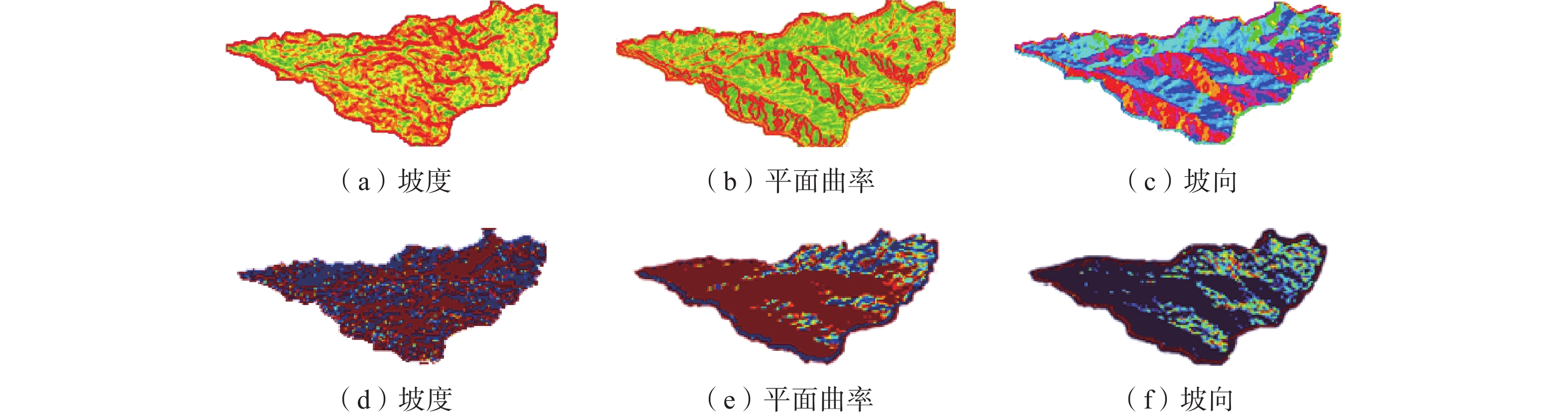
![]()
图 7 地质因子与CNN中间层可视化
注:(a)(b)(c)为ArcGIS中计算得到的坡度、曲率、坡向(d)(e)(f)为CNN中间层特征可视化中提取结果。
Figure 7. Geological factors and CNN intermediate layer visualization
表 1 样本分类
Table 1 Sample classification
所属类别 正样本 负样本 类别 0 1 2 3 4 5 流域面积/km2 (1, 24] (26, 64] (69, 109] (1, 12] (12, 27] (30, 45] 数据增强/个 45 51 44 48 46 54  下载: 导出CSV
表 2 正负2分类测试混淆矩阵
Table 2 Confusion matrix for two-class testing (Positive, negative)
预测值 真实值 正 负 正 110 20 负 37 113
下载: 导出CSV
表 3 6分类测试混淆矩阵
Table 3 Confusion matrix for 6-category testing
预测值 真实值 0 1 2 3 4 5 0 27 1 0 10 7 1 1 0 23 1 0 5 14 2 0 0 58 0 0 0 3 5 0 0 38 3 0 4 5 0 0 0 29 2 5 10 0 0 0 2 39
下载: 导出CSV
表 4 试验结果
Table 4 Summary of experimental results
数据(90∶10) 数据(80∶20) 数据(70∶30) Test2-acc Test6-acc Test2-acc Test6-acc Test2-acc Test6-acc DCFAMNet 80%±4% 76%±4% 68%±5% 64%±5% 62%±5% 60%±5% ResNet18[20] 76%±3% 70%±3% 64%±3% 64%±3% 57%±5% 57%±5% ResNet34 78%±5% 71%±3% 69%±a>% 65%±5% 60%±5% 58%±5% ShuffleNet[21] 72%±6% 70%±6% 60%±8% 56%±8% 55%±6% 51%±6% SENet[22] 78%±4% 65%±4% 62%±4% 54%±4% 54%±5% 48%±5% 注:DCFAMNet为轻量型卷积神经网络—融合注意力机制的双通道网络(Dual-Channel Fusion Attention Mechanism Network),ResNet指网络模型Residual Network,ShuffleNet指网络模型ShufleNet Volution,SENet指网络模型Squeeze-and-Excitation Network。
下载: 导出CSV
表 5 模型性能
Table 5 Summary of model performance
Precision-2 Recall-2 F1-score-2 Kappa-2 Precision-6 Recall-6 DCFAMNet 0.75 0.85 0.79 0.59 0.75 0.75 ResNet18 0.68 0.79 0.73 0.43 0.66 0.68 ResNet34 0.68 0.85 0.78 0.58 0.68 0.74 ShuffleNet 0.80 0.69 0.79 0.45 0.78 0.65 SENet 0.69 0.83 0.78 0.56 0.65 0.73
下载: 导出CSV
表 6 消融试验结果
Table 6 Pertubation experiment results
precision recall F1-score kappa Test2-acc Test6-acc basic Net 0.66 0.50 0.59 0.40 65%±5% 60%±5% with ECA 0.75 0.81 0.74 0.50 75%±4% 70%±4% with 3DCNN 0.66 0.55 0.60 0.45 72%±5% 68%±5% with DepSep 0.72 0.71 0.75 0.48 71%±3% 71%±3% DCFAMNet 0.75 0.85 0.79 0.59 80%±4% 76%±4% 注:basic Net为基础网络模型,ECA表示Efficient Channel Attention,3DCNN为3D卷积,DepSep为深度卷积,DCFAMNet为轻量型卷积神经网络—融合注意力机制的双通道网络(Dual-Channel Fusion Attention Mechanism Network)。
下载: 导出CSV
表 7 注意力模型对比结果
Table 7 Comparison results of attention models
注意力模型 Test2-acc Test6-acc basic Net 75%±4% 71%±4% With SE 76%±3% 72%±3% With CBAM 78%±5% 75%±5% With ECA 80%±4% 76%±4% 注:basic Net为基础网络模型,SE表示Squeeze-and-Excitation,CBAM表示Convolutional Block Attention Module,ECA表示Efficient Channel Attention。
下载: 导出CSV
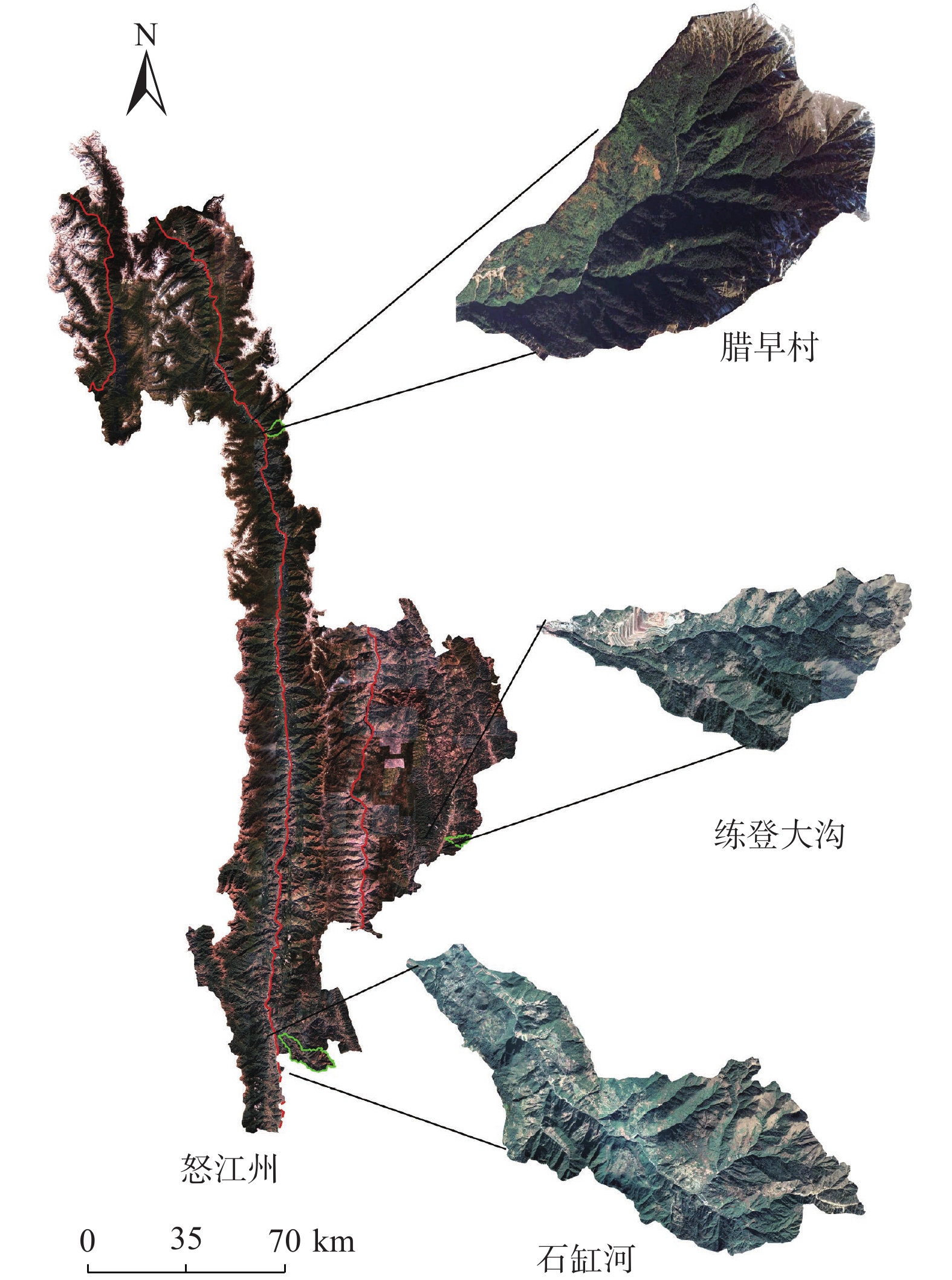
表 8 地貌条件、物源条件
Table 8 Geomorphic conditions and provenance conditions
地貌条件和物源条件 练登大沟 腊早村 石缸河 主沟长度/km 10.300 7.824 24.342 面积/km2 16.260 16.450 87.174 高程差/km 1.386 2.426 2.590 坡降比 0.130 0.310 0.106 平均坡度/(°) 16.170 21.200 12.160 Melton指数 0.340 0.598 0.277 土壤条件 不饱和雏形土、简育高活性淋溶土 高活性淋溶土 高活性淋溶土、铁质低活性强酸土、腐殖质低活性强酸土、
简育高活性强酸土、饱和雏形土地层岩性 板岩、千枚岩、杂砂岩、长石砂岩、沙岩、
石灰岩和其他碳酸盐岩片麻岩、板岩、千枚岩、
片岩、花岗岩花岗岩、玄武岩、片麻岩、板岩、千枚岩、砂岩、杂砂岩、
长石砂岩、页岩、石灰石、其他碳酸盐岩植被条件[26] 疏林地、高覆盖度草地、其它建设用地 有林地、灌木林、疏林地、
高覆盖度草地水田、旱地、有林地、疏林地、高覆盖度草地、中覆盖度草地
下载: 导出CSV
-
[1] 刘文,王猛,朱赛楠,等. 基于光学遥感技术的高山极高山区高位地质灾害链式特征分析——以金沙江上游典型堵江滑坡为例[J]. 中国地质灾害与防治学报,2021,32(5):29 − 39. [LIU Wen,WANG Meng,ZHU Sainan,et al. An analysis on chain characteristics of highstand geological disasters in high mountains and extremely high mountains based on optical remote sensing technology:A case study of representative large landslides in upper reach of Jinsha River[J]. The Chinese Journal of Geological Hazard and Control,2021,32(5):29 − 39. (in Chinese with English abstract)] LIU Wen, WANG Meng, ZHU Sainan, et al. An analysis on chain characteristics of highstand geological disasters in high mountains and extremely high mountains based on optical remote sensing technology: A case study of representative large landslides in upper reach of Jinsha River[J]. The Chinese Journal of Geological Hazard and Control, 2021, 32(5): 29 − 39. (in Chinese with English abstract)
[2] 时岩,张金霞,刘兴荣,等. 陇南市武都区滑坡转化为泥石流灾害链形成机理及防治措施研究[J]. 水利规划与设计,2022(10):136 − 139. [SHI Yan,ZHANG Jinxia,LIU Xingrong,et al. Study on the formation mechanism of landslide-induced mudslide disaster chain and prevention and control measures in Wudou District,Longnan City[J]. Water Resources Planning and Design,2022(10):136 − 139. (in Chinese)] DOI: 10.3969/j.issn.1672-2469.2022.10.027 SHI Yan, ZHANG Jinxia, LIU Xingrong, et al. Study on the formation mechanism of landslide-induced mudslide disaster chain and prevention and control measures in Wudou District, Longnan City[J]. Water Resources Planning and Design, 2022(10): 136 − 139. (in Chinese) DOI: 10.3969/j.issn.1672-2469.2022.10.027
[3] 郑琅,张欣,王立娟. 四川省甘洛县山体滑坡应急调查与成因机制分析[J]. 人民长江,2022,53(8):117 − 122. [ZHENG Lang,ZHANG Xin,WANG Lijuan. Emergency investigation and formation mechanism of landslide in Ganluo County,Sichuan Province[J]. Yangtze River,2022,53(8):117 − 122. (in Chinese with English abstract)] ZHENG Lang, ZHANG Xin, WANG Lijuan. Emergency investigation and formation mechanism of landslide in Ganluo County, Sichuan Province[J]. Yangtze River, 2022, 53(8): 117 − 122. (in Chinese with English abstract)
[4] CARRARA A,MERENDA L. Landslide inventory in northern Calabria,southern Italy[J]. Geological Society of America Bulletin,1976,87(8):1153. DOI: 10.1130/0016-7606(1976)87<1153:LIINCS>2.0.CO;2
[5] ZHOU Wei,TANG Chuan,VAN ASCH T W J,et al. A rapid method to identify the potential of debris flow development induced by rainfall in the catchments of the Wenchuan earthquake area[J]. Landslides,2016,13(5):1243 − 1259. DOI: 10.1007/s10346-015-0631-0
[6] 侯圣山,曹鹏,陈亮,等. 基于数值模拟的耳阳河流域泥石流灾害危险性评价[J]. 水文地质工程地质,2021,48(2):143 − 151. [HOU Shengshan,CAO Peng,CHEN Liang,etal. Risk assessment of debris flow disasters in Eryang River basin based on numerical simulation[J]. Hydrogeology & Engineering Geology,2021,48(2):143 − 151. (in Chinese with English abstract)] HOU Shengshan, CAO Peng, CHEN Liang, etal. Risk assessment of debris flow disasters in Eryang River basin based on numerical simulation[J]. Hydrogeology & Engineering Geology, 2021, 48(2): 143 − 151. (in Chinese with English abstract)
[7] 乔渊,刘铁骥,陈亮,等. 基于Massflow模型的甘肃省岷县二马沟泥石流危险性评价[J]. 水利水电技术,2020,51(4):184 − 192. [QIAO Yuan,LIU Tieji,CHEN Liang,et al. Massflow model-based hazard assessment on Erma gully debris flow in Minxian County of Gansu Province[J]. Water Resources and Hydropower Engineering,2020,51(4):184 − 192. (in Chinese with English abstract)] QIAO Yuan, LIU Tieji, CHEN Liang, et al. Massflow model-based hazard assessment on Erma gully debris flow in Minxian County of Gansu Province[J]. Water Resources and Hydropower Engineering, 2020, 51(4): 184 − 192. (in Chinese with English abstract)
[8] ROWBOTHAM D,DE SCALLY F,LOUIS J. The identification of debris torrent basins using morphometric measures derived within a GIS[J]. Geografiska Annaler:Series A,Physical Geography,2005,87(4):527-537.
[9] 丛威青,潘懋,李铁锋,等. 降雨型泥石流临界雨量定量分析[J]. 岩石力学与工程学报,2006,25(增刊1):2808 − 2812. [CONG Weiqing,PAN Mao,LI Tiefeng,et al. Quantitative analysis of critical rainfall of rainfall debris flow[J]. Chinese Journal of Rock Mechanics and Engineering,2006,25(Sup1):2808 − 2812. (in Chinese with English abstract)] CONG Weiqing, PAN Mao, LI Tiefeng, et al. Quantitative analysis of critical rainfall of rainfall debris flow[J]. Chinese Journal of Rock Mechanics and Engineering, 2006, 25(Sup1): 2808 − 2812. (in Chinese with English abstract)
[10] 王常明,田书文,王翊虹,等. 泥石流危险性评价:模糊c均值聚类-支持向量机法[J]. 吉林大学学报(地球科学版),2016,46(4):1168 − 1175. [WANG Changming,TIAN Shuwen,WANG Yihong,et al. Risk assessment of debris flow:A method of SVM based on FCM[J]. Journal of Jilin University (Earth Science Edition),2016,46(4):1168 − 1175. (in Chinese with English abstract)] WANG Changming, TIAN Shuwen, WANG Yihong, et al. Risk assessment of debris flow: A method of SVM based on FCM[J]. Journal of Jilin University (Earth Science Edition), 2016, 46(4): 1168 − 1175. (in Chinese with English abstract)
[11] 张书豪,吴光. 随机森林与GIS的泥石流易发性及可靠性[J]. 地球科学,2019,44(9):3115 − 3134. [ZHANG Shuhao,WU Guang. Debris flow susceptibility and its reliability based on random forest and GIS[J]. Earth Science,2019,44(9):3115 − 3134. (in Chinese with English abstract)] ZHANG Shuhao, WU Guang. Debris flow susceptibility and its reliability based on random forest and GIS[J]. Earth Science, 2019, 44(9): 3115 − 3134. (in Chinese with English abstract)
[12] 孔艳,王保云,王乃强,等. 滇西高山峡谷区泥石流危险性评价——以怒江傈僳族自治州为例[J]. 云南师范大学学报(自然科学版),2019,39(3):63 − 70. [KONG Yan,WANG Baoyun,WANG Naiqiang,et al. Debris flows risk assessment in the alpine canyon of western Yunnan:A case study in Nujiang Lisu autonomous prefecture[J]. Journal of Yunnan Normal University (Natural Sciences Edition),2019,39(3):63 − 70. (in Chinese with English abstract)] KONG Yan, WANG Baoyun, WANG Naiqiang, et al. Debris flows risk assessment in the alpine canyon of western Yunnan: A case study in Nujiang Lisu autonomous prefecture[J]. Journal of Yunnan Normal University (Natural Sciences Edition), 2019, 39(3): 63 − 70. (in Chinese with English abstract)
[13] 钱闪光,李云,侯克鹏,等. 怒江州贡山县从尼泥石流形成条件与诱发机理[J]. 四川建材,2018,44(12):94 − − 95. [QIAN Shanguang,LI Yun,HOU Kepeng,et al. Formation conditions and induced mechanism of debris flow in Congni,Gongshan County,Nujiang Prefecture[J]. Sichuan Building Materials,2018,44(12):94 − 95. (in Chinese)] QIAN Shanguang, LI Yun, HOU Kepeng, et al. Formation conditions and induced mechanism of debris flow in Congni, Gongshan County, Nujiang Prefecture[J]. Sichuan Building Materials, 2018, 44(12): 94 − 95. (in Chinese)
[14] 李益敏,杨蕾,魏苏杭. 基于小流域单元的怒江州泥石流易发性评价[J]. 长江流域资源与环境,2019,28(10):2419 − 2428. [LI Yimin,YANG Lei,WEI Suhang. Susceptibility assessment of debris flow in Nujiang befecture based on the catchment[J]. Resources and Environment in the Yangtze Basin,2019,28(10):2419 − 2428. (in Chinese with English abstract)] LI Yimin, YANG Lei, WEI Suhang. Susceptibility assessment of debris flow in Nujiang befecture based on the catchment[J]. Resources and Environment in the Yangtze Basin, 2019, 28(10): 2419 − 2428. (in Chinese with English abstract)
[15] STRAHLER A N. Quantitative analysis of watershed geomorphology[J]. Transactions,American Geophysical Union,1957,38(6):913. DOI: 10.1029/TR038i006p00913
[16] 刘德玉,贾贵义,李松,等. 地形因素对白龙江流域甘肃段泥石流灾害的影响及权重分析[J]. 水文地质工程地质,2019,46(3):33 − 39. [LIU Deyu,JIA Guiyi,LI Song,et al. Impacts of topographical factors on debris flows and weight analysis at the Gansu segment of the Bailongjiang River Basin[J]. Hydrogeology & Engineering Geology,2019,46(3):33 − 39. (in Chinese with English abstract)] DOI: 10.16030/j.cnki.issn.1000-3665.2019.03.05 LIU Deyu, JIA Guiyi, LI Song, et al. Impacts of topographical factors on debris flows and weight analysis at the Gansu segment of the Bailongjiang River Basin[J]. Hydrogeology & Engineering Geology, 2019, 46(3): 33 − 39. (in Chinese with English abstract) DOI: 10.16030/j.cnki.issn.1000-3665.2019.03.05
[17] 李彩侠,马煜,何元勋. 泥石流致灾因子敏感性分析——以四川都江堰龙溪河流域为例[J]. 中国地质灾害与防治学报,2020,31(5):32 − 39. [LI Caixia,MA Yu,HE Yuanxun. Sensitivity analysis of debris flow to environmental factors:A case of Longxi River Basin in Dujiangyan,Sichuan Province[J]. The Chinese Journal of Geological Hazard and Control,2020,31(5):32 − 39. (in Chinese with English abstract)] LI Caixia, MA Yu, HE Yuanxun. Sensitivity analysis of debris flow to environmental factors: A case of Longxi River Basin in Dujiangyan, Sichuan Province[J]. The Chinese Journal of Geological Hazard and Control, 2020, 31(5): 32 − 39. (in Chinese with English abstract)
[18] WANG Qilong,WU Banggu,ZHU Pengfei,et al. ECA-net:efficient channel attention for deep convolutional neural networks[C]//2020 IEEE/CVF Conference on Computer Vision and Pattern Recognition (CVPR). June 13-19,2020,Seattle,WA,USA. IEEE,2020:11531 − 11539.
[19] HOWARD A G,ZHU Menglong,CHEN Bo,et al. MobileNets:efficient convolutional neural networks for mobile vision applications[EB/OL]. 2017:arXiv:1704.04861.
[20] HE Kaiming,ZHANG Xiangyu,REN Shaoqing,et al. Deep residual learning for image recognition[C]//2016 IEEE Conference on Computer Vision and Pattern Recognition (CVPR). June 27-30,2016,Las Vegas,NV,USA. IEEE,2016:770 − 778.
[21] ZHANG Xiangyu,ZHOU Xinyu,LIN Mengxiao,et al. ShuffleNet:An extremely efficient convolutional neural network for mobile devices[C]//2018 IEEE/CVF Conference on Computer Vision and Pattern Recognition. June 18-23,2018,Salt Lake City,UT,USA. IEEE,2018:6848 − 6856.
[22] HU Jie,SHEN Li,SUN Gang. Squeeze-and-excitation networks[C]//2018 IEEE/CVF Conference on Computer Vision and Pattern Recognition. June 18-23,2018,Salt Lake City,UT,USA. IEEE,2018:7132 − 7141.
[23] 张国平,徐晶,毕宝贵. 滑坡和泥石流灾害与环境因子的关系[J]. 应用生态学报,2009,20(3):653 − 658. [ZHANG Guoping,XU Jing,BI Baogui. Relations of landslide and debris flow hazards to environmental factors[J]. Chinese Journal of Applied Ecology,2009,20(3):653 − 658. (in Chinese with English abstract)] ZHANG Guoping, XU Jing, BI Baogui. Relations of landslide and debris flow hazards to environmental factors[J]. Chinese Journal of Applied Ecology, 2009, 20(3): 653 − 658. (in Chinese with English abstract)
[24] 张书豪,吴光,张乔,等. 基于子流域特征的泥石流易发性评价[J]. 水文地质工程地质,2018,45(2):142 − 149. [ZHANG Shuhao,WU Guang,ZHANG Qiao,et al. Debris-flow susceptibility assessment using the characteristic factors of a catchment[J]. Hydrogeology & Engineering Geology,2018,45(2):142 − 149. (in Chinese with English abstract)] ZHANG Shuhao, WU Guang, ZHANG Qiao, et al. Debris-flow susceptibility assessment using the characteristic factors of a catchment[J]. Hydrogeology & Engineering Geology, 2018, 45(2): 142 − 149. (in Chinese with English abstract)
[25] 李益敏,袁静,蒋德明,等. 基于GIS的西南高山峡谷区滑坡风险性评价——以怒江州泸水市为例[J]. 西北师范大学学报(自然科学版),2021,57(6):94 − 102. [LI Yimin,YUAN Jing,JIANG Deming,et al. Risk assessment of landslide disasters in alpine canyon area based on GIS:Taking Lushui City,Nujiang Prefecture as an example[J]. Journal of Northwest Normal University (Natural Science),2021,57(6):94 − 102. (in Chinese with English abstract)] LI Yimin, YUAN Jing, JIANG Deming, et al. Risk assessment of landslide disasters in alpine canyon area based on GIS: Taking Lushui City, Nujiang Prefecture as an example[J]. Journal of Northwest Normal University (Natural Science), 2021, 57(6): 94 − 102. (in Chinese with English abstract)
[26] 中国科学院资源环境科学数据中心(http://www.resdc.cn/). (2019). 中国土地利用数据(1980-2015).国家青藏高原科学数据中心. [Resource and Environment Science Data Center of Chinese Academy of Sciences (http://www.resdc.cn/). (2019). China Land Use Data (1980-2015). National Qinghai-Tibet Plateau Scientific Data Center.] Resource and Environment Science Data Center of Chinese Academy of Sciences (http://www.resdc.cn/). (2019). China Land Use Data (1980-2015). National Qinghai-Tibet Plateau Scientific Data Center.
[27] 王欢,陈廷方,丁明涛. 泥石流对岩性的敏感性分析及其在危险性评价中的应用[J]. 长江流域资源与环境,2012,21(3):385 − 390. [WANG Huan,CHEN Tingfang,DING Mingtao. Sensitivity analysis to lithology and application in risk assessment of debris flow[J]. Resources and Environment in the Yangtze Basin,2012,21(3):385 − 390. (in Chinese with English abstract)] WANG Huan, CHEN Tingfang, DING Mingtao. Sensitivity analysis to lithology and application in risk assessment of debris flow[J]. Resources and Environment in the Yangtze Basin, 2012, 21(3): 385 − 390. (in Chinese with English abstract)
[28] 鲁科,余斌,韩林,等. 泥石流流域岩性的坚固系数与暴发频率的关系[J]. 地球科学进展,2011,26(9):980 − 990. [LU Ke,YU Bin,HAN Lin,et al. A study of the relationship between frequency of debris flow and the lithology in the catchment of debris flow[J]. Advances in Earth Science,2011,26(9):980 − 990. (in Chinese with English abstract)] LU Ke, YU Bin, HAN Lin, et al. A study of the relationship between frequency of debris flow and the lithology in the catchment of debris flow[J]. Advances in Earth Science, 2011, 26(9): 980 − 990. (in Chinese with English abstract)
[29] 何坤,胡卸文,刘波,等. 川藏铁路某车站泥石流群发育特征及对线路的影响[J]. 水文地质工程地质,2021,48(5):137 − 149. [HE Kun,HU Xiewen,LIU Bo,et al. Characteristics and potential engineering perniciousness of the debris flow group in one station of the Sichuan-Tibet Railway[J]. Hydrogeology & Engineering Geology,2021,48(5):137 − 149. (in Chinese with English abstract)] HE Kun, HU Xiewen, LIU Bo, et al. Characteristics and potential engineering perniciousness of the debris flow group in one station of the Sichuan-Tibet Railway[J]. Hydrogeology & Engineering Geology, 2021, 48(5): 137 − 149. (in Chinese with English abstract)
[30] 施蕾蕾,陈宁生,杨成林,等. 娃娃沟流域泥石流活动与植被关系探讨[J]. 水土保持研究,2008,15(3):96 − 99. [SHI Leilei,CHEN Ningsheng,YANG Chenglin,et al. Relationships between vegetation and debris flow in well-vegetated Wawagou valley[J]. Research of Soil and Water Conservation,2008,15(3):96 − 99. (in Chinese with English abstract)] SHI Leilei, CHEN Ningsheng, YANG Chenglin, et al. Relationships between vegetation and debris flow in well-vegetated Wawagou valley[J]. Research of Soil and Water Conservation, 2008, 15(3): 96 − 99. (in Chinese with English abstract)
[31] 戚国庆,黄润秋. 泥石流成因机理的非饱和土力学理论研究[J]. 中国地质灾害与防治学报,2003,14(3):12 − 15. [QI Guoqing,HUANG Runqiu. Study on genetic and mechanical analysis of debris flow based on unsaturated soils mechanics[J]. The Chinese Journal of Geological Hazard and Control,2003,14(3):12 − 15. (in Chinese with English abstract)] QI Guoqing, HUANG Runqiu. Study on genetic and mechanical analysis of debris flow based on unsaturated soils mechanics[J]. The Chinese Journal of Geological Hazard and Control, 2003, 14(3): 12 − 15. (in Chinese with English abstract)
-
期刊类型引用(4)
1. 李朝辉,张柯宏. 藏东南某滑坡成因分析及稳定性评价. 铁道勘察. 2025(01): 13-19 .  百度学术
百度学术
2. 李骏,李状,苗晋杰,刘宏伟,刘笑,高伊航. 山西省阳城县北窑村滑坡特征及成因分析. 华北地质. 2025(01): 95-102 . 百度学术
3. 侯艳权,王义春,李岑,佘燕飞,修唯,掌旭. 极端天气多源融合预警方法研究. 微型电脑应用. 2024(08): 73-76 . 百度学术
4. 张昊天,王新刚,罗力,王友林,郭倩怡,薛晨. 秦巴山区典型碎石土抗剪强度变化规律及其在堆积层滑坡机理分析中的应用. 中国地质灾害与防治学报. 2024(05): 50-58 . 本站查看
其他类型引用(0)


计量
- 文章访问数: 74
- HTML全文浏览量: 5
- PDF下载量: 21
- 被引次数: 4
 邮件订阅
邮件订阅 RSS
RSS