

Early identification of hidden dangers of lanslides based on the combination of ascending and descending orbits InSAR and high spatial resolution optical remote sensing: A case study of landslides in Longde County, southern Ningxia
-
摘要: 宁夏隆德县地处六盘山西麓,地质条件复杂,受季节性强降雨影响,滑坡地质灾害频发,给当地人民生命财产安全造成了严重威胁。针对宁夏东部和南部植被覆盖率高的特点,文章利用合成孔径雷达升降轨差分干涉测量(Synthetic Aperture Radar Difference Interferometry, D-InSAR)技术与高分辨率光学遥感相结合,对隆德县展开滑坡隐患早期识别与探测研究。首先通过干涉叠加技术(Stacking)分别获得2019年1月—2020年5月隆德县升轨和降轨方向的雷达视向形变速率,然后结合高分辨率光学遥感影像产品和数字高程模型(DEM),基于专家判识经验建立适用于该研究区的滑坡隐患形态和变形解译标志,完成全县范围的滑坡隐患综合遥感识别和地面调查工作。本次遥感调查工作共识别滑坡隐患47处,野外调查验证21处,其中核实16处,准确率为71.4%。实地调查结果验证了综合遥感识别与探测技术在宁夏南部地质灾害隐患遥感调查的适用性和可行性,同时也验证了识别结果的准确性,为宁夏南部地区滑坡防治和突发地质灾害应急提供了重要的科学依据。Abstract: Longde County in southern Ningxia is located at the western foot of Liupan mountain. Geological conditions is complicated. Affected by seasonal heavy rainfall, landslides and geological disasters occur frequently in the area, which poses a serious threat to local people's lives and property. In consideration of the high fractional vegetation in study area, integrated remote sensing technologies combined of Synthetic Aperture Radar Difference Interferometry technology and high spatial resolution optical remote sensing have been used in early detection of Landslides in the Longde county. Stacking technology has been used to calculate the rate of deformation from 2019.01 to 2021.05, in the direction of ascending and descending orbit. Combining high spatial resolution optical remote sensing images and digital elevation model (DEM), the interpretation key of landslide in the area deformation has been established. Then the early detection of landslides and ground survey in Longde county have been done. Through the integrated remote sensing technologies, 47 landslides were detected. 21 landslides were surveyed by field, of which 16 were verified, with an accuracy rate of 71.4%. The results of field survey demonstrated the applicability and feasibility of integrated remote sensing technology in the detection of landslides in southern Ningxia. Meanwhile, and the accuracy of the results in Longde county has been testified. The results of the early detection through integrated remote sensing technology provided significant scientific bases for the landslide protection and emergency response to sudden geological disasters in southern Ningxia.
-
-
![]()
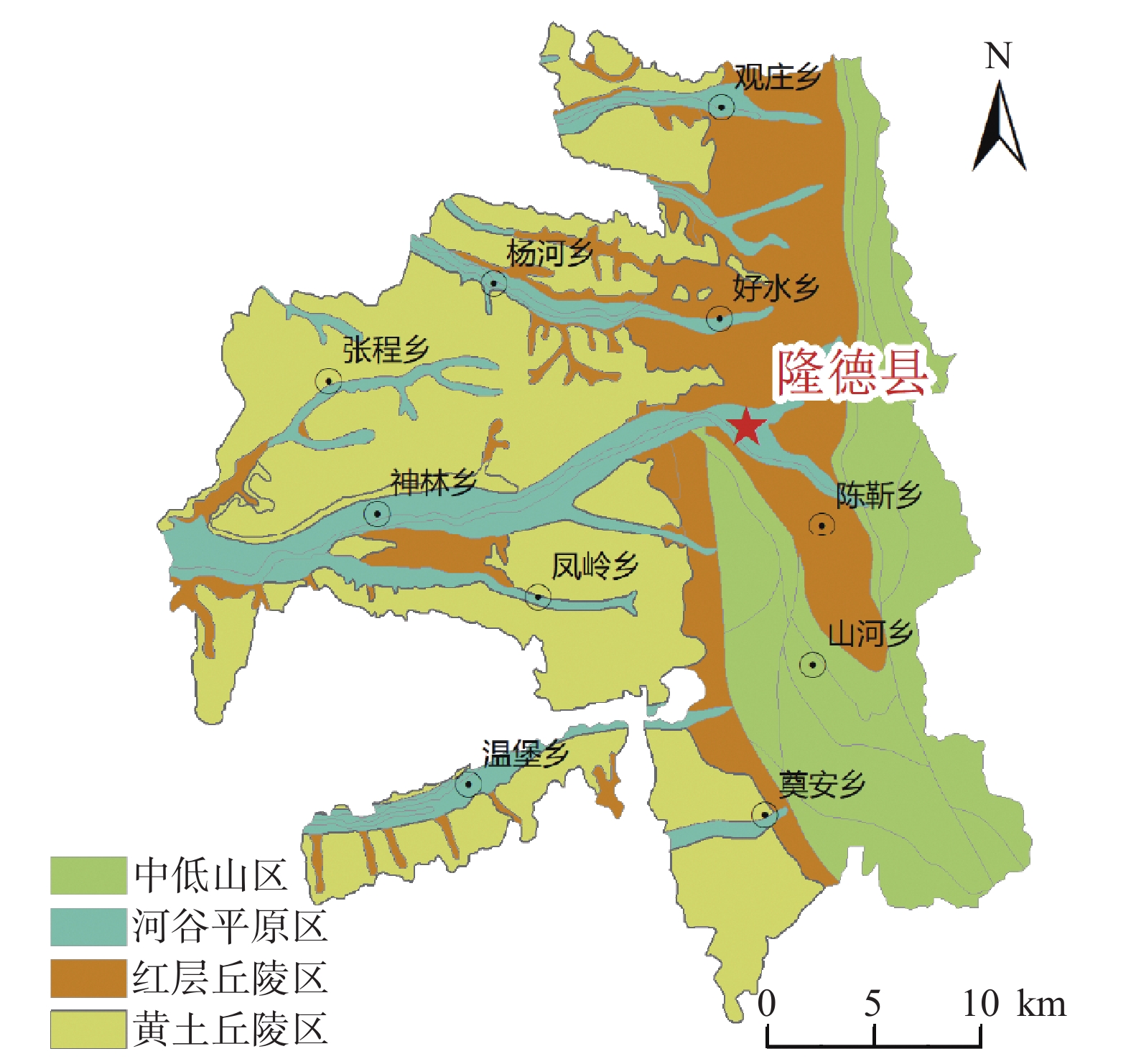
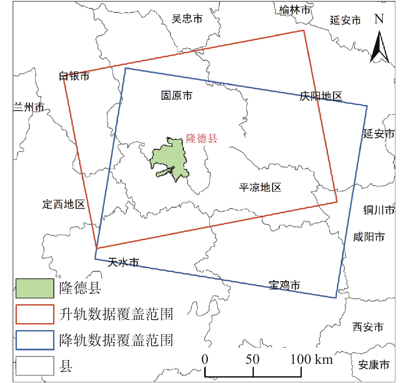
图 1 研究区位置及雷达卫星影像覆盖图
Figure 1. Location of study area and coverage of radar satellite image
![]()
![]()
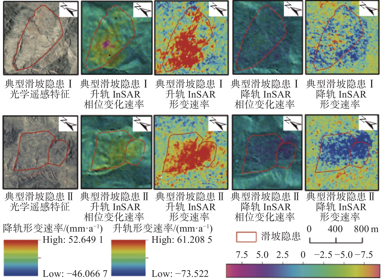
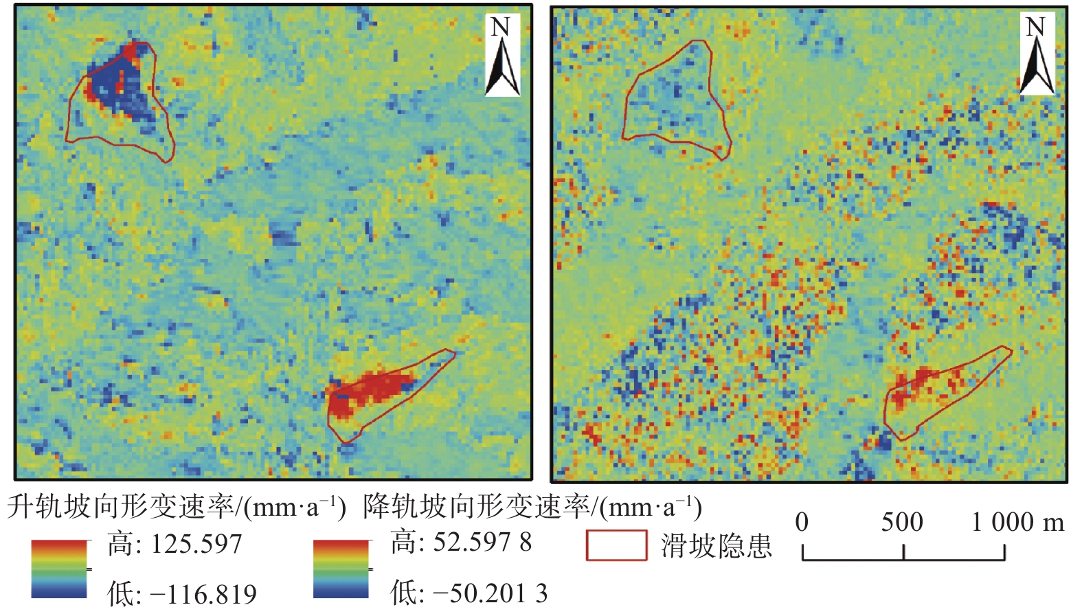
图 9 后海村和水磨村滑坡隐患坡向形变图
Figure 9. Deformation in slope direction(Houhai Village and Shuimo Village)
表 1 Sentinel-1A卫星属性
Table 1 Sentinel-1A satellite parameters
卫星名称 幅宽/km 入射角/(°) 极化方式 影像时间 影像数量 Sentinel-1A 250 29.1~46.0 双极化:HH+HV、VV+HH单极化:HH、VV 2019年1月—2020年5月 升轨42期降轨43期  下载: 导出CSV
直接解译标志 表现为圈椅、双沟同源、椭圆、长条、簸箕形、舌形、弧形、不规则多边形等。斜坡上部分坡体较周围地形平缓,但能与侵蚀平台、阶地等区分。 间接
解译标志颜色 滑坡体显浅色色调,后缘弧形线性清晰,与外围深色调基岩反差明显。 地形地貌 常分布在沟谷、河流等陡峭边坡的局部凹陷地段或河道偏移异常部位。滑坡体后缘发育有弧形异常影像,包括陡坎、地形变异线和色调异常线等。滑坡体前缘边坡向谷地凸出,常有地形微突起及小型崩滑流堆积影像。 水系特征 常形成相对独立封闭的汇水区和特殊的水网系统或发育有与邻近区域不协调的网纹结构,往往导致现代水系变迁等地形变异现象。
下载: 导出CSV
-
[1] 高丽琰, 余江宽, 张幼莹, 等. 基于GIS的层次分析法在宁夏地质灾害易发性评价的应用[J]. 防灾科技学院学报,2017,19(4):8 − 15. [GAO Liyan, YU Jiangkuan, ZHANG Youying, et al. Application of GIS-based analytic hierarchy process in geological hazards assessment in Ningxia region[J]. Journal of Institute of Disaster Prevention,2017,19(4):8 − 15. (in Chinese with English abstract) DOI: 10.3969/j.issn.1673-8047.2017.04.002 [2] 王成, 孟方, 李天斌. 宁夏回族自治区区域地质志 [R]. 银川: 宁夏回族自治区地质调查院, 2013: 23−30. WANG Cheng, MENG Fang, LI Tianbin. Regional geology of the Ningxia Hui Autonomous Region [R]. Yinchuan: Geology Survey Institute of Ningxia, 2013: 23−30. (in Chinese)
[3] 吕世民, 吴凯, 杜光波, 等. 宁夏隆德县地质灾害发育特征及形成条件分析[J]. 水利与建筑工程学报,2015,13(6):42 − 47. [LYU Shimin, WU Kai, DU Guangbo, et al. Development characteristics and formation conditions of geological hazards in Longde County of Ningxia[J]. Journal of Water Resources and Architectural Engineering,2015,13(6):42 − 47. (in Chinese with English abstract) DOI: 10.3969/j.issn.1672-1144.2015.06.008 [4] 许强, 董秀军, 李为乐. 基于天-空-地一体化的重大地质灾害隐患早期识别与监测预警[J]. 武汉大学学报(信息科学版),2019,44(7):957 − 966. [XU Qiang, DONG Xiujun, LI Weile. Integrated space-air-ground early detection, monitoring and warning system for portential catastrophic geohazards[J]. Geomatics and Information Science of Wuhan University,2019,44(7):957 − 966. (in Chinese with English abstract) [5] 许强. 对地质灾害隐患早期识别相关问题的认识与思考[J]. 武汉大学学报(信息科学版),2020,45(11):1651 − 1659. [XU Qiang. Understanding and consideration of related issues in early identification of potential geohazards[J]. Geomatics and Information Science of Wuhan University,2020,45(11):1651 − 1659. (in Chinese with English abstract) [6] 葛大庆. 地质灾害早期识别与监测预警中的综合遥感应用[J]. 城市与减灾,2018(6):53 − 60. [GE Daqing. Comprehensive application of remote sensing in early identification, monitoring and early warning in geological disasters[J]. City and Disaster Reduction,2018(6):53 − 60. (in Chinese with English abstract) DOI: 10.3969/j.issn.1671-0495.2018.06.011 [7] 葛大庆, 戴可人, 郭兆成, 等. 重大地质灾害隐患早期识别中综合遥感应用的思考与建议[J]. 武汉大学学报·信息科学版,2019,44(7):949 − 956. [GE Daqing, DAI Keren, GUO Zhaocheng, et al. Integrated space-air-ground early detection, monitoringand warning system for potential catastrophic geohazards[J]. Geomatics and Information Science of Wuhan University,2019,44(7):949 − 956. (in Chinese with English abstract) [8] 葛大庆, 郭兆成. 重大地质灾害隐患早期识别中综合遥感应用的思考[J]. 中国应急救援,2019(1):10 − 14. [GE Daqing, GUO Zhaocheng. Thoughts of early identification of serious geological hazards with integrated remote sensing technologies[J]. China Emergency Rescue,2019(1):10 − 14. (in Chinese with English abstract) DOI: 10.3969/j.issn.1673-5579.2019.01.002 [9] ZEBKER H A, ROSEN P A. Atmospheric artifacts in interferometric SAR surface deformation and topographic maps [J]. Department of Electrical Engineering and Geophysics, University of Stanford, Stanford, CA. 1996.
[10] FERRETTI A, PRATI C, ROCCA F. Permanent scatterers in SAR interferometry[J]. IEEE Transactions on Geoscience and Remote Sensing,2001,39(1):8 − 20. DOI: 10.1109/36.898661
[11] COLESANTI C, FERRETTI A, NOVALI F, et al. SAR monitoring of progressive and seasonal ground deformation using the permanent scatterers technique[J]. IEEE Transactions on Geoscience and Remote Sensing,2003,41(7):1685 − 1701. DOI: 10.1109/TGRS.2003.813278
[12] FERRETTI A, PRATI C, ROCCA F. Nonlinear subsidence rate estimation using permanent scatterers in differential SAR interferometry[J]. IEEE Transactions on Geoscience and Remote Sensing,2000,38(5):2202 − 2212. DOI: 10.1109/36.868878
[13] LANARI R, MORA O, MANUNTA M, et al. A small-baseline approach for investigating deformations on full-resolution differential SAR interferograms[J]. IEEE Transactions on Geoscience and Remote Sensing,2004,42(7):1377 − 1386. DOI: 10.1109/TGRS.2004.828196
[14] WERNER C, WEGMULLER U, STROZZI T, et al. Interferometric point target analysis for deformation mapping[C]//IGARSS 2003.2003 IEEE International Geoscience and Remote Sensing Symposium. Proceedings (IEEE Cat. No. 03CH37477). July 21−25, 2003, Toulouse, France. IEEE, 2003: 4362−4364.
[15] FERRETTI A, FUMAGALLI A, NOVALI F, et al. A new algorithm for processing interferometric data-stacks: SqueeSAR[J]. IEEE Transactions on Geoscience and Remote Sensing,2011,49(9):3460 − 3470. DOI: 10.1109/TGRS.2011.2124465
[16] 李振洪, 宋闯, 余琛, 等. 卫星雷达遥感在滑坡灾害探测和监测中的应用: 挑战与对策[J]. 武汉大学学报(信息科学版),2019,44(7):967 − 979. [LI Zhenhong, SONG Chuang, YU Chen, et al. Application of satellite remote sensing to landslide detection and mornitoring: Challenges and solutions[J]. Geomatics and Information Science of Wuhan University,2019,44(7):967 − 979. (in Chinese with English abstract) [17] FRUNEAU B, ACHACHE J, DELACOURT C. Observation and modelling of the Saint-Étienne-de-Tinée landslide using SAR interferometry[J]. Tectonophysics,1996,265(3/4):181 − 190.
[18] RAUCOULES D, MAISONS C, CARNEC C, et al. Monitoring of slow ground deformation by ERS radar interferometry on the Vauvert salt mine (France)[J]. Remote Sensing of Environment,2003,88(4):468 − 478. DOI: 10.1016/j.rse.2003.09.005
[19] 王绚, 范宣梅, 杨帆, 等. 植被茂密山区地质灾害遥感解译方法研究[J]. 武汉大学学报(信息科学版),2020,45(11):1771 − 1781. [WANG Xuan, FAN Xuanmei, YANG Fan, et al. Remote sensing interpretation method of geological hazards in lush mountainous area[J]. Geomatics and Information Science of Wuhan University,2020,45(11):1771 − 1781. (in Chinese with English abstract) [20] 张幼莹, 余江宽, 步凡, 等. “高分二号”卫星在黄土地质灾害解译中的应用研究[J]. 测绘与空间地理信息,2017,40(11):31 − 34. [ZHANG Youying, YU Jiangkuan, BU Fan, et al. Application of GF-2Satellite to geological hazard interpretation in loess plateau[J]. Geomatics & Spatial Information Technology,2017,40(11):31 − 34. (in Chinese with English abstract) DOI: 10.3969/j.issn.1672-5867.2017.11.009 [21] 彭令, 徐素宁, 梅军军, 等. 地震滑坡高分辨率遥感影像识别[J]. 遥感学报,2017,21(4):509 − 518. [PENG Ling, XU Suning, MEI Junjun, et al. Earthquake-induced landslide recognition using high-resolution remote sensing images[J]. Journal of Remote Sensing,2017,21(4):509 − 518. (in Chinese with English abstract) [22] 陆会燕, 李为乐, 许强, 等. 光学遥感与InSAR结合的金沙江白格滑坡上下游滑坡隐患早期识别[J]. 武汉大学学报(信息科学版),2019,44(9):1342 − 1354. [LU Huiyan, LI Weile, XU Qiang, et al. Early detection of landslides in the upstream and downstream areas of the Baige landslide, the Jinsha River based on optical remote sensing and InSAR technologies[J]. Geomatics and Information Science of Wuhan University,2019,44(9):1342 − 1354. (in Chinese with English abstract) [23] CARLÀ T, INTRIERI E, RASPINI F, et al. Perspectives on the prediction of catastrophic slope failures from satellite InSAR[J]. Scientific Reports,2019,9:14137. DOI: 10.1038/s41598-019-50792-y
[24] DIAO X P, WU K, HU D H, et al. Combining differential SAR interferometry and the probability integral method for three-dimensional deformation monitoring of mining areas[J]. International Journal of Remote Sensing,2016,37(21):5196 − 5212. DOI: 10.1080/01431161.2016.1230284
[25] 刘星洪, 姚鑫, 周振凯, 等. 滑坡灾害InSAR应急排查技术方法研究[J]. 地质力学学报,2018,24(2):229 − 237. [LIU Xinghong, YAO Xin, ZHOU Zhenkai, et al. Study of the technique for landslide rapid recognition by InSAR[J]. Journal of Geomechanics,2018,24(2):229 − 237. (in Chinese with English abstract) DOI: 10.12090/j.issn.1006-6616.2018.24.02.024 [26] HU J, LI Z W, DING X L, et al. Resolving three-dimensional surface displacements from InSAR measurements: a review[J]. Earth-Science Reviews,2014,133:1 − 17. DOI: 10.1016/j.earscirev.2014.02.005
[27] HU X, WANG T, PIERSON T C, et al. Detecting seasonal landslide movement within the Cascade landslide complex (Washington) using time-series SAR imagery[J]. Remote Sensing of Environment,2016,187:49 − 61. DOI: 10.1016/j.rse.2016.10.006
[28] ERIKSEN H Ø, LAUKNES T R, LARSEN Y, et al. Visualizing and interpreting surface displacement patterns on unstable slopes using multi-geometry satellite SAR interferometry (2D InSAR)[J]. Remote Sensing of Environment,2017,191:297 − 312. DOI: 10.1016/j.rse.2016.12.024
[29] PRICE E J, SANDWELL D T. Small-scale deformations associated with the 1992 Landers, California, earthquake mapped by synthetic aperture radar interferometry phase gradients[J]. Journal of Geophysical Research:Solid Earth,1998,103(B11):27001 − 27016. DOI: 10.1029/98JB01821
[30] STROZZI T, WEGMULLER U, WERNER C, et al. Measurement of slow uniform surface displacement with mm/year accuracy[C]//IGARSS 2000. IEEE 2000 International Geoscience and Remote Sensing Symposium. Taking the Pulse of the Planet: The Role of Remote Sensing in Managing the Environment. Proceedings (Cat. No. 00CH37120). July 24-28, 2000, Honolulu, HI, USA. IEEE, 2000: 2239-2241.
[31] 彭令, 徐素宁, 梅军军, 等. 资源三号卫星在汶川震区滑坡快速识别中的应用方法研究[J]. 遥感技术与应用,2018,33(1):185 − 192. [PENG Ling, XU Suning, MEI Junjun, et al. Research on Wenchuan earthquake-induced landslides rapid recognition from ZY-3 imagery[J]. Remote Sensing Technology and Application,2018,33(1):185 − 192. (in Chinese with English abstract) [32] CASCINI L, FORNARO G, PEDUTO D. Advanced low- and full-resolution DInSAR map generation for slow-moving landslide analysis at different scales[J]. Engineering Geology,2010,112(1/2/3/4):29 − 42.
[33] 董文, 潘建平, 阳振宇, 等. 高分二号卫星数据在地质灾害调查中的应用: 以重庆万州区为例[J]. 中国地质灾害与防治学报,2019,30(1):106 − 111. [DONG Wen, PAN Jianping, YANG Zhenyu, et al. Application of GF-2 satellite data in geological hazard survey: A case study in Wanzhou district of Chongqing City[J]. The Chinese Journal of Geological Hazard and Control,2019,30(1):106 − 111. (in Chinese with English abstract) [34] 潘腾. 高分二号卫星的技术特点[J]. 中国航天,2015(1):3 − 9. [PAN Teng. The technology characteristics of Gaofen-2 satellite[J]. Aerospace China,2015(1):3 − 9. (in Chinese with English abstract) [35] 王智勇, 文强, 李晶晶, 等. 从开拓到引领: 赋能国内商业遥感卫星运行服务[J]. 中国测绘,2019(10):28 − 30. [WANG Zhiyong, WEN Qiang, LI Jingjing, et al. From pioneering to leading: Enabling domestic commercial remote sensing satellite operation services[J]. China Surveying and Mapping,2019(10):28 − 30. (in Chinese with English abstract) DOI: 10.3969/j.issn.1005-6831.2019.10.008 [36] ZHANG Y, MENG X M, JORDAN C, et al. Investigating slow-moving landslides in the Zhouqu region of China using InSAR time series[J]. Landslides,2018,15(7):1299 − 1315. DOI: 10.1007/s10346-018-0954-8
-
期刊类型引用(45)
1. 陈玉波,徐世光,陈梦瑞. 以确定性系数法为基础的不同滑坡易发性评价模型对比分析——以云南保山盆地为例. 中国地质灾害与防治学报. 2025(01): 119-130 .  本站查看
本站查看
2. 令狐文霜,丁勇. 基于信息量模型法的安徽省黄山区地质灾害易发性分析. 地质灾害与环境保护. 2025(01): 15-20 . 百度学术
3. 王喜,徐世光,陈玉波. 基于确定性系数与随机森林模型的滑坡易发性评价. 江西科学. 2025(02): 375-384 . 百度学术
4. 刘玥,申玉松,李旭,张迪. 基于不同耦合模型的区域地质灾害易发性评价——以河南商城县为例. 中国地质调查. 2024(01): 83-92 . 百度学术
5. 申玉松,张宸,王艺杰,张迪. 基于CF-LR模型的河南省信阳市地质灾害易发性评价. 地质与资源. 2024(01): 74-81+134 . 百度学术
6. 余文秀,李秀珍,郑玲静,孔纪名,邵其其,熊华勇,谢成. 基于信息量-Scoops3D联合模型的地质灾害易发性评价. 防灾减灾工程学报. 2024(03): 649-659 . 百度学术
7. 梁波. 韶关市武江区斜坡类地质灾害易发性评价. 城市建设理论研究(电子版). 2024(21): 183-186 . 百度学术
8. 王华锋,陈洪海,贾琛,马龙,亓贞才,张晓飞,马建伟,张晔. 基于GIS分析的鲁中南低山丘陵区地质灾害风险评价. 山东国土资源. 2024(10): 66-72 . 百度学术
9. 龙承柱,吴海斌. 地质灾害风险调查(1:5万)评价及成果分析——以珠海市香洲区为例. 资源信息与工程. 2024(05): 26-29+35 . 百度学术
10. 梁峰,江攀和,唐广,刘双. 基于AHP及信息量模型的凤冈县地质灾害易发性评价. 贵州地质. 2024(04): 446-455 . 百度学术
11. 王涛,李鹏洋,逯兴娅,苏生瑞,董永超. 陕西省韩城市地质灾害易发性评价. 甘肃科学学报. 2023(02): 55-62 . 百度学术
12. 邹聪聪. 基于GIS的修水县地质灾害危险性评估研究. 测绘与空间地理信息. 2023(04): 69-73 . 百度学术
13. 王成楠,吴琳伟,宋勇,贺婷,王彪,赵影,胡旭东. 江西省寻乌县滑坡易发性评价模型及精度对比研究. 资源环境与工程. 2023(02): 171-182 . 百度学术
14. 宋勇,王成楠,王彪,赵影. 基于信息量法和结果检验的定南县地质灾害易发性评价. 防灾减灾学报. 2023(02): 26-35 . 百度学术
15. 林幸俤. 基于信息量法罗源县地质灾害易发性评价. 能源与环境. 2023(03): 2-6+10 . 百度学术
16. 孙中瑞,李阳,罗显新,伏顺成. 广东省南雄市地质灾害风险性评价. 黑龙江环境通报. 2023(06): 88-90 . 百度学术
17. 蒋文学,李益敏,杨雪,邓选伦,杨一铭. 基于斜坡单元的怒江州滑坡易发性研究. 水土保持学报. 2023(05): 160-167 . 百度学术
18. 刘玉娟. 基于GIS加权叠加的区域地质灾害易发性评价. 兰州文理学院学报(自然科学版). 2023(05): 37-42 . 百度学术
19. 赵卫东,冯子豪,吴兴付,尹俊杰,季斌. 基于空间插值与典型滑坡体的滑坡灾害气象预警模型研究. 灾害学. 2023(04): 56-62+106 . 百度学术
20. 王美华. 基于信息量、信息量-逻辑回归模型综合法的地质灾害易发性研究——以诸暨市马剑镇为例. 化工矿产地质. 2023(04): 347-358 . 百度学术
21. 赵正平,关昕,明璐璐,柯福阳,张玉梅,和春元. 云南省水汽特征及其与滑坡形变量关联性分析. 测绘科学. 2023(12): 38-50 . 百度学术
22. 温鑫,范宣梅,陈兰,刘世康. 基于信息量模型的地质灾害易发性评价:以川东南古蔺县为例. 地质科技通报. 2022(02): 290-299 . 百度学术
23. 屠水云,张钟远,付弘流,徐世光,邓明国,何例春,刘金宇. 基于CF与CF-LR模型的地质灾害易发性评价. 中国地质灾害与防治学报. 2022(02): 96-104 . 本站查看
24. 万洋,郭捷,马凤山,刘佳,宋烨炜. 基于最大熵模型的中尼交通廊道滑坡易发性分析. 中国地质灾害与防治学报. 2022(02): 88-95 . 本站查看
25. 王瑞瑞,刘冰. 基于多尺度分析和综合评价法的登封市地质灾害易发性评价. 资源环境与工程. 2022(03): 351-356+397 . 百度学术
26. 熊小辉,汪长林,白永健,铁永波,高延超,李光辉. 基于不同耦合模型的县域滑坡易发性评价对比分析——以四川普格县为例. 中国地质灾害与防治学报. 2022(04): 114-124 . 本站查看
27. 胡屿,陈静,刘勇,陆安良,侯江勇. 基于GIS与信息量法的贵州省丹寨县地质灾害易发性评价. 贵州科学. 2022(05): 60-64 . 百度学术
28. 周萍,邓辉,张文江,薛东剑,吴先谭,卓文浩. 基于信息量模型和机器学习方法的滑坡易发性评价研究——以四川理县为例. 地理科学. 2022(09): 1665-1675 . 百度学术
29. 邹凤钗,邹银先,陶小郎,吕东. 基于GIS分析的万山区地质灾害风险评价. 贵州大学学报(自然科学版). 2022(06): 117-124 . 百度学术
30. 田仕雄,张路飞,孟思宇,潘志辉. AHP-信息量模型在斜坡类地质灾害易发性评价中的应用. 河北地质大学学报. 2022(06): 62-68 . 百度学术
31. 邹凤钗,冷洋洋,陶小郎,尹彦迪. 逻辑回归和信息量模型在山区滑坡易发性评价中适宜性的分析. 贵州地质. 2022(03): 280-286 . 百度学术
32. 郭飞,王秀娟,陈玺,王力,谢明娟,李玉,谭建民. 基于不同模型的赣南地区小型削方滑坡易发性评价对比分析. 中国地质灾害与防治学报. 2022(06): 125-133 . 本站查看
33. 黄佳铭,刘羊,楼康明,谭建辉,陈凌伟. 基于GIS和信息量模型的坡面孤石发育程度评价. 城市勘测. 2022(06): 185-191 . 百度学术
34. 雷天浩,黄东荣,聂文昌,万川,卢凯. 浙江省东阳市佐村镇地质灾害形成条件及易发性评价. 东华理工大学学报(自然科学版). 2022(06): 560-568 . 百度学术
35. 王成楠,宋勇,赵影,张勇,向兴达,胡旭东. 基于加权信息量法和逻辑回归信息量法的定南县地质灾害易发性评价. 东华理工大学学报(自然科学版). 2022(06): 569-580 . 百度学术
36. 刘乐,杨智,孙健,刘钦,彭鹏,段俊斌. 安徽黄山市徽州区地质灾害危险性评价研究. 中国地质灾害与防治学报. 2021(02): 110-116 . 本站查看
37. 李菊芳. 桩板墙不同类型挂板的技术经济比较. 中国地质灾害与防治学报. 2021(02): 135-142 . 本站查看
38. 李萍,叶辉,谈树成. 基于层次分析法的永德县地质灾害易发性评价. 水土保持研究. 2021(05): 394-399+406 . 百度学术
39. 张静,田述军,侯鹏鹂. 基于面积-高程和面积-坡度积分的泥石流物质供给能力分析. 中国地质灾害与防治学报. 2021(04): 9-16 . 本站查看
40. 罗守敬,王珊珊,付德荃. 北京山区突发性地质灾害易发性评价. 中国地质灾害与防治学报. 2021(04): 126-133 . 本站查看
41. 周天伦,曾超,范晨,毕鸿基,龚恩慧,刘晓. 基于快速聚类-信息量模型的汶川及周边两县滑坡易发性评价. 中国地质灾害与防治学报. 2021(05): 137-150 . 本站查看
42. 于淼,邢会歌,胡士瑜. 基于信息量-逻辑回归模型的泥石流易发性评价——以四川省石棉县为例. 人民长江. 2021(12): 107-114 . 百度学术
43. 赵毅斌,邓必荣,王玺. 基于Logistic-信息量耦合模型的地质灾害易发性分区研究——以赣南地区某重点城镇为例. 地质灾害与环境保护. 2021(04): 45-51 . 百度学术
44. 黄立鑫,郝君明,李旺平,周兆叶,贾佩钱. 基于RBF神经网络-信息量耦合模型的滑坡易发性评价——以甘肃岷县为例. 中国地质灾害与防治学报. 2021(06): 116-126 . 本站查看
45. 马晓峰,朱浩濛,张义顺,毛烨峰. 省级地质灾害风险评价技术方法研究——以浙江省为例. 浙江国土资源. 2021(S1): 57-65 . 百度学术
其他类型引用(16)

计量
- 文章访问数: 542
- HTML全文浏览量: 283
- PDF下载量: 210
- 被引次数: 61
 邮件订阅
邮件订阅 RSS
RSS