

Surface deformation analysis of Hohhot urban area based on SAR data from Sentinel-1A
-
摘要: 为了实现对呼和浩特市城区形变监测,采用永久散射体合成孔径雷达干涉测量(PS-InSAR)技术,对2017年3月—2021年4月期间25景呼和浩特市城区Sentinel-1A数据进行时序干涉处理,提取了城区地表沉降信息,并分析了主要沉降中心沉降原因。结果表明:呼和浩特市城区地表存在5个明显的沉降中心,整体地表平均年沉降速率3.65 mm/a,平均累计沉降量为15.50 mm,其沉降主要原因是由于地下水过度开采。Sentinel-1A数据具有时间基线短、影像数量足、数据免费等优点,利于InSAR时序分析,可满足同类城区地表形变监测工作,服务城市安全。
-
关键词:
- 地表沉降 /
- Sentinel-1A /
- 时序分析 /
- 永久散射体干涉技术 /
- 呼和浩特
Abstract: In order to realize the monitoring of deformation in the urban area of Hohhot city, this paper uses the permanent scatterer synthetic aperture radar interferometry (PS-InSAR) technique to perform temporal interferometric processing on 25 scenes of Sentinel-1A data from March 2017 to April 2021 in the urban area of Hohhot city to extract the surface subsidence information in the urban area and analyze the causes of subsidence in the main subsidence centers. The results show that there are five obvious centres of subsidence in the urban area of Hohhot, and that the overall average annual surface subsidence rate is 3.65 mm/a, with an average cumulative subsidence of 15.50 mm. The subsidence is mainly due to over-exploitation of groundwater. Given that the free Sentinel-1A data has the advantages of short time baseline and sufficient number of images, it is conducive to InSAR time series analysis, which can meet similar urban surface deformation monitoring work and serve urban safety.-
Keywords:
- ground subsidence /
- Sentinel-1A /
- time series analysis /
- permanent scatterer interferometry /
- Hohhot
-
0. 引言
近年来,呼和浩特市经济发展迅速,主城区人口快速增长,城市建设及工业建设用地等持续增加。2005年之前,地下水水源为呼和浩特市区唯一水源[1]。2006年以后,“引黄入呼”工程引黄河水10×104 m3/d。城市供水可开采量 25. 8×10⁴ m3/d,但是需水量高达49.1×104 m3/ d[2],需水量差额从地下抽取,导致近十多年来地下水位年均下降1.7 m,市城南地面相比于10多年前沉降了约10 cm[3]。
21世纪初至今,PS-InSAR技术在地表沉降监测方面取得许多成果[4]。张剑[5]基于Sentinel-1数据,运用PS-InSAR技术监测得到兰州市中心城区的年均形变速率和时序上的累计沉降量,总结了该地区的沉降规律,并结合兰州市的工程施工项目和黄土湿陷等资料分析了地面沉降原因。廖明生等[6]利用PS-InSAR技术对上海市进行地面沉降监测,得到各时期的沉降速率,并与同时期水准数据对比验证,结果达到毫米级精度。同时基于时间序列高分辨率SAR影像还能够监测大型单体建筑物及地铁等线状地物,说明了PS-InSAR技术的应用潜力与有效性。马秀露[7]利用2015—2018年间的36景Sentinel-1A影像,采用PS-InSAR技术监测了西安高铁北站附近地区,得到郑西高铁西安段及周边区域的沉降速率,并对结果进行详细分析。郑佳兵等[8]基于北京平原区的PS-InSAR时序监测,构建北京平原区沉降数据,道路交通影响区占总沉降区87.81%,定量分析了道路交通对该区沉降的影响,得出道路交通是沉降的主要因素之一,并且是引起北京平原区沉降外因的结论。张勤等[9]通过总结InSAR等技术的特点及应用,总结并展望高精度空间监测技术融合,认为PS-InSAR技术提高了InSAR形变监测的精度。众多研究表明PS-InSAR方法对微小形变有着较高的敏感度,能够提高监测沉降的精度[10]。
呼和浩特市发展迅速,城市建筑工程活动加剧,地下水的进一步开采对地面稳定性造成持续性破坏[11],该市地面沉降需要给予特别关注。林凯[12]对呼和浩特市地铁1号线呼钢东站主体建设工程变形监测数据进行了模型对比分析,研究发现卡尔曼滤波-BP神经网络组合模型相比于单一模型的预测精度提高了30%,稳定性更好,通过对28个地铁墙顶竖向位移点进行30期的观测,其中累计沉降量最大值16.52 mm。胡勇平[13]对呼和浩特市回民区万达广场变形进行了预测分析,通过建立六种模型发现基坑从开挖、浇筑直到回填整体变形处于稳定状态。张凯等[14]对呼和浩特轨道交通2号线某车站基坑开挖进行了沉降监测分析,发现各监测点监测值均在可控范围之内,其中围护结构总体变形较大。杨红樱等[15]研究了降雨对呼和浩特地震台形变观测的影响。
以上研究仅局限于局部形变监测,未开展呼和浩特城区整体的沉降监测。文章以呼和浩特市城区为研究对象,采用PS-InSAR技术进行地面沉降监测分析,提取呼和浩特市城区地面沉降信息,以期对城市安全提供相关分析。
1. 研究区与数据
1.1 研究区概况
(1)地理位置。研究区地处大青山山脉南部,南抵大黑河,西到内蒙古医科大学(金川校区),东至大黑河,面积约694 km2。研究区地理位置如图1所示。
(2)地形地貌。研究区位于土默川平原,地貌属于大青山山前冲洪积倾斜平原[16],地势北高南低[17]。向东部和北部地势逐渐增高,向西部和南部地势逐渐降低。
(3)水文条件。该区域河流为黄河水系,是主要饮用水来源,地表水资源多在雨季6—8月,含沙多、峰大量小、时令性强[18]。市区在近20—30年开始大规模开采地下水,开发利用程度较高[19]。
(4)第四系土层性质及分布简述。由中国地质调查局发展研究中心K-49-28呼和浩特市幅1∶20万区域地质图空间数据库(https://geocloud.cgs.gov.cn/#/home)可知,研究区地层以第四系为主,是大青山山前凹陷地带,地表出露大部分为全新统,次为更新统。其中冲积层(
研究区第四纪地层环境特征详见张恒星[20]第二章。地质剖面图参考李潇瀚等[21]图1与图2、张泽鹏等[22]图1、赵瑞科等[23]图1、石鸿蕾等[24]图1的呼和浩特城区部分。研究区第四纪地质略图见张翼龙[25]图2—5。
1.2 数据来源
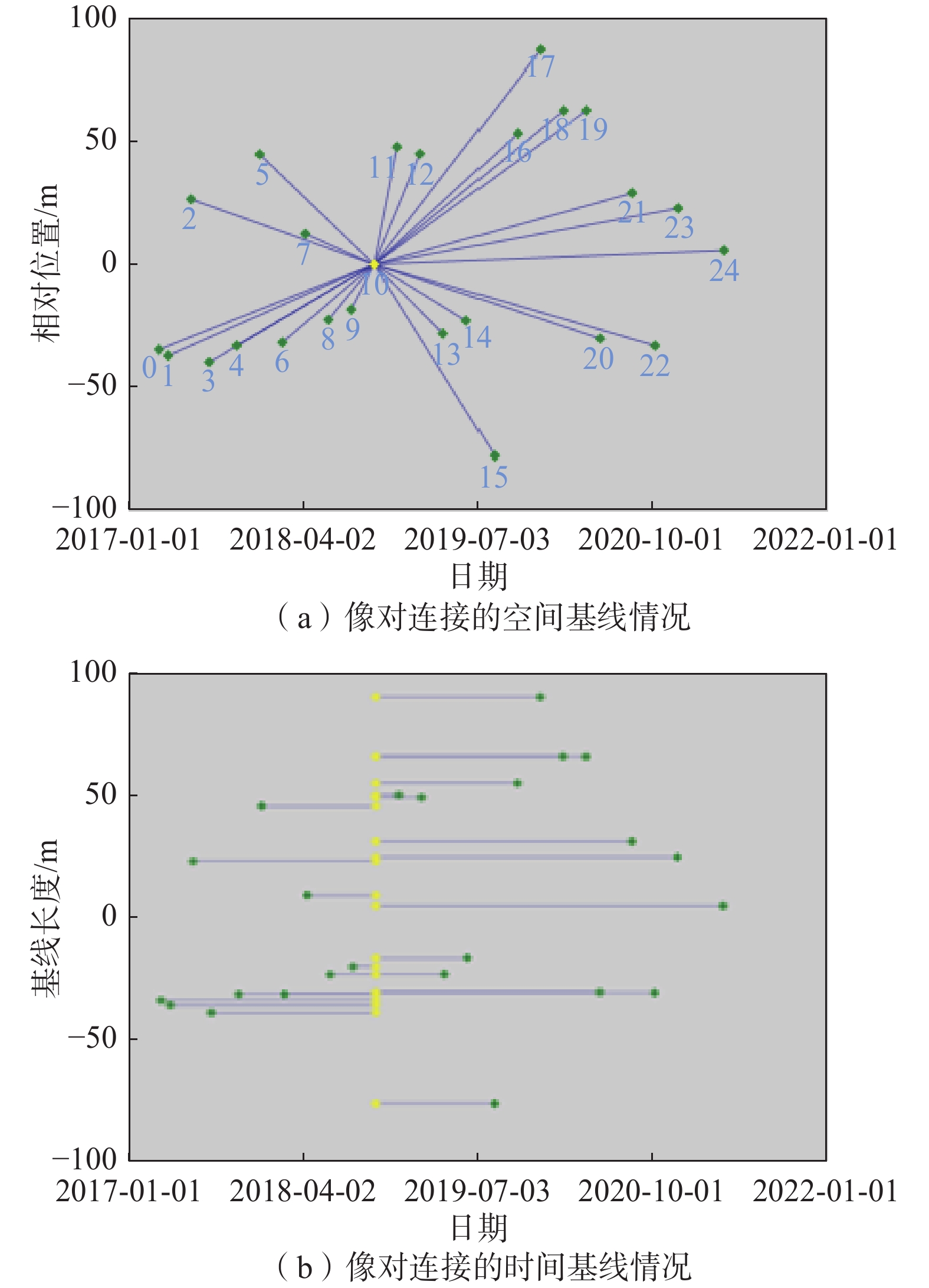
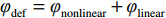
本次试验时间为2017年3月—2021年4月,选取了覆盖呼和浩特市城区25景Sentinel-1A升轨影像,影像信息详见表1,VV极化方式,IW成像模式。选取2018-10-04期为超级主影像,计算24景影像与超级主影像的时空基线(图2)。时序数据空间基线最大为2019年12月10期的87.43 m,最短为2021年4月3期的5.72 m,满足试验需求[11]。
表 1 研究所采用的Sentinel-1A数据参数Table 1. Summary of the Sentinel-1A data parameters used in the study影像编号 成像日期 空间基线距/m 时间基线距/d 影像编号 成像日期 空间基线距/m 时间基线距/d 1 2017-03-19 −34.87 −564 14 2019-04-02 −28.33 180 2 2017-04-12 −37.39 −540 15 2019-06-01 −23.04 240 3 2017-06-11 26.72 −480 16 2019-08-12 −78.11 312 4 2017-07-29 −40.10 −432 17 2019-10-11 53.56 372 5 2017-10-09 −33.23 −360 18 2019-12-10 87.43 432 6 2017-12-08 45.08 −300 19 2020-02-08 62.98 492 7 2018-02-06 −31.88 −240 20 2020-04-08 63.07 552 8 2018-04-07 12.50 −180 21 2020-05-14 −30.41 588 9 2018-06-06 −22.68 −120 22 2020-08-06 29.23 672 10 2018-08-05 −18.48 −60 23 2020-10-05 −33.29 732 11 2018-10-04 0.00 0 24 2020-12-04 23.03 792 12 2018-12-03 48.10 60 25 2021-04-03 5.72 912 13 2019-02-01 45.28 120 2. 数据处理
2.1 PS-InSAR原理简介
PS-InSAR从所有覆盖在同一地区的多景时序InSAR影像,基于时空基线,选择一幅为超级主影像,其余的作为辅影像,与主影像进行配准处理,根据影像在时间序列上的幅度与相位信息的稳定性,获得很多相关性、稳定性高的点;再剔除地形相位与干涉处理,提取带有永久散射体目标信息的差分干涉相位,二次差分相邻目标的差分干涉相位;最后建立起基于两次差分后形变相位模型,求解形变相位、分离大气延迟相位,得出研究区的形变信息与地形残余信息[26]。
Ferretti等 于1999年提出了PS-InSAR技术,通过对同一区域的多时相雷达影像,进行时空基线的综合评估,选出超级主影像,其余作为副影像,配准主副影像,同时生成干涉图[27],则干涉相位由式(1)表示:
(1) 式中:
(2) 将式(2)带入式(1)整理后得式(3):
(3) 式中:
则对第N景干涉图PS点的干涉相位整理得式(4):
(4) 2.2 数据处理
数据处理使用由美国Exelis Visual Information Solutions公司开发的ENVI(The environment for visualizing images)遥感图像处理平台下的SARscape高级雷达处理模块[29]。对Sentinel-1A影像数据进行数据导入,研究区裁剪,连接图生成(时空基线分布如图2所示),干涉工作流(包括配准、干涉图生成、去平、振幅离差指数计算),PS两次模型反演,地理编码。选用30 m格网间隔的SRTM DEM去除地形相位[30]。
3. 结果与分析
3.1 地面沉降分布
通过InSAR时序处理,分别获得2017年3月—2021年4月呼和浩特市城区累计沉降量和平均沉降速率(软件自动选择和分配)。从研究区整体来看,研究区西部沉降量明显大于东部,沉降较为严重区域集中分布在回民区与玉泉区交界处,金川开发区。呼和浩特市累计沉降量最大沉降为194.80 mm,研究区平均累计沉降值为15.50 mm(图3)。最大平均沉降速率为49.27 mm/a,研究区平均沉降速率的平均值为3.65 mm/a(图4—5)。
![]() 图 3 呼和浩特市2017—2021年地表累计形变量Figure 3. Cumulative surface settlement of Hohhot City from 2017 to 2021
图 3 呼和浩特市2017—2021年地表累计形变量Figure 3. Cumulative surface settlement of Hohhot City from 2017 to 2021![]() 图 4 2017—2021年研究区平均形变速率图Figure 4. Average settlement rate of the study area from 2017 to 2021
图 4 2017—2021年研究区平均形变速率图Figure 4. Average settlement rate of the study area from 2017 to 20213.2 沉降原因分析
结果表明,研究时间段内研究区总体呈现下沉趋势,且有较为严重的沉降区。这与文献[31-33]对该市的沉降研究趋势是相同的,呼和浩特垂直形变速率图详见文献[32]中图6。文献[32]认为漏斗沉降区域的生成是地下水的过度开采所致,其中文献[1、17、29]发现该地区地下水位多年来持续下降。
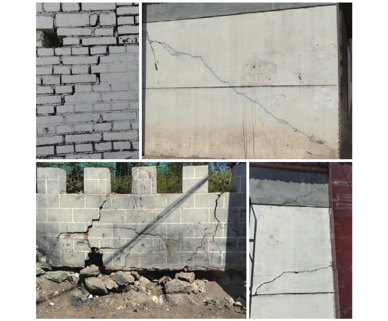
![]() 图 6 实地调查照片Figure 6. Field photos of concrete building cracks due to ground settlement
图 6 实地调查照片Figure 6. Field photos of concrete building cracks due to ground settlement分别用A—E作为标识的5个代表区域,标识位置见图3,并对5个沉降中心进行了实地调研,将造成呼和浩特市城区较大沉降的主要因素分为两类:地下水开采和人工建造两个层面进行分析。
A沉降区主要包括地铁1号线坝堰(机场)站、白塔西站、什兰岱站和呼和浩特白塔国际机场。该区是研究区东部沉降较为严重的区域,最大沉降速率18.15 mm/a,平均沉降速率3.06 mm/a(图5)。该区沉降原因是由于在地铁等地面建筑物施工过程中,对地下水抽取,同时地下水抽取过多使得地表受力不均衡,因此产生沉降。在工程完期后,由于土体的自固结也会导致沉降的可能,增加地面沉降的不确定因素[33]。A区是研究区重要的交通运输枢纽,该区域人流量大,建筑密集。为保障地铁1号线和机场的运营安全,应持续监测该地区沉降和加强地基的维护,以减缓地表差异形变对地铁和机场运营的影响。
E区主要以加工场、小区居多,人口数量大。其沉降中心集中在工业区和新建建筑附近,向四周沉降逐渐减小,形成一个漏斗沉降区,道路塌陷情况严重,墙体存在开裂现象(图6)。该区域为五个研究区最大形变区域,最大沉降速率43.72 mm/a,平均沉降速率12.46 mm/a。该地区沉降原因是由于地下水超采。其原因由文献[34-36]佐证:台阁牧镇附近的水头下降速率超过2.0 m/a,属于严重超采区,地下水超采区位置详见文献[34]图2、文献[35]附图1,其评价结果与地下水开采程度及水头的变化情况基本一致,具有可靠性[34]。
B、C、D沉降区分别位于西乌素图回迁小区周围、回民区南部城发绿园小区及广龙苑小区周围、玉泉区北部丽和阳光城及西岸国际小区周围。B区最大沉降量111.70 mm,平均沉降量36.34 mm;C区最大沉降量99.2 mm,平均沉降量41.07mm;D区最大沉降量111.30 mm,平均沉降量50.99 mm,其中D区平均沉降量为最大。3个沉降区分别以各自为最大沉降量中心向四周呈递减趋势,且D区和C区有连片趋势。经过实地考察以及遥感影像分析,相比于周围区域,3个沉降区高层居民楼、学区房等建筑物荷载较多,从而加重地表沉降,且根据中国科学院资源环境科学数据中心提供的中国土壤质地空间分布数据可知,呼和浩特市的土壤质地以砂土为主,占比40%~60%,粉砂土占比20%~40%,表明呼和浩特市土壤质地松散,不利于储水。同时在建筑物等地上设施建设过程中容易导致松散的土壤被压实,发生地面沉降,与文献[37]分析一致。
4. 精度验证
此次研究有5个地铁控制网二等精密水准测量数据来验证精度。
后不塔气站监测日期在2017年4月—2018年7月,期间道路地表竖向位移测点最终累计变形值介于−12.2~13.0 mm,整体呈下沉变化,Sentinel-1A影像InSAR结果显示在后不塔气地铁站形变值介于−12.1~12.9 mm之间。
将军衙署站在监测日期在2017年3月—2018年6月,共观测27次。地表监测累计量介于−7.36~5 mm。Sentinel-1A影像InSAR结果显示形变值介于−10~6.6 mm。
其他三个站(内蒙古展览馆站、西龙王庙站、西二环路站)Sentinel-1A影像InSAR形变结果均在地表监测形变范围之内误差最大为24.7 mm,大部分误差保持在5 mm以内。以上结果说明两者结果保持了较好的一致性。
误差较大的原因主要为水准测量获取的“点”形变信息,PS-InSAR获取的是一个分辨单元的沉降量,属于“面”形变信息。Sentinel-1A影像分辨率是5 m×20 m,PS-InSAR中“面”的形变受其附近5~20 m区域的影响,还受到散射特性强的地面反射物影响,PS-InSAR和水准测量结果的比较是“面”和“点”结果的比较[38],所以二者不能完全对应,存在误差。其次为研究区部分地区地形起伏大,存在地形残差[39-41]。
5. 结论
本文阐述了运用25景覆盖呼和浩特市城区的Sentinel-1A升轨SAR影像和PS-InSAR技术,提取城区整体地表形变情况,并分析了影响因素。研究结果表明:
(1)Sentinel-1A数据影像数量足,回访周期短,利于InSAR时序分析提取城区地表形变分析结果,服务于城市安全监测。
(2)在监测时间段内,呼和浩特市地表呈现出整体较大范围的下沉,其中西侧沉降量大于东侧。文中共识别出5个显著沉降漏斗,主要原因为地下水超采和人类活动。总结出的显著沉降区下沉原因,与已有文献结果比较,沉降分布规律以及相对位置基本吻合,对呼和浩特城区整体地表形变作出了监测分析。
(3)建议出台政策有效地限制地面地下建筑活动,有效管理地下水开采、城市人口、工业活动等。同时,对已存在的严重沉降区应该给予充分的补救措施,加强对该地区的地表形变监测。
-
![]()
图 3 呼和浩特市2017—2021年地表累计形变量
Figure 3. Cumulative surface settlement of Hohhot City from 2017 to 2021
![]()
图 4 2017—2021年研究区平均形变速率图
Figure 4. Average settlement rate of the study area from 2017 to 2021
![]()
图 6 实地调查照片
Figure 6. Field photos of concrete building cracks due to ground settlement
表 1 研究所采用的Sentinel-1A数据参数
Table 1 Summary of the Sentinel-1A data parameters used in the study
影像编号 成像日期 空间基线距/m 时间基线距/d 影像编号 成像日期 空间基线距/m 时间基线距/d 1 2017-03-19 −34.87 −564 14 2019-04-02 −28.33 180 2 2017-04-12 −37.39 −540 15 2019-06-01 −23.04 240 3 2017-06-11 26.72 −480 16 2019-08-12 −78.11 312 4 2017-07-29 −40.10 −432 17 2019-10-11 53.56 372 5 2017-10-09 −33.23 −360 18 2019-12-10 87.43 432 6 2017-12-08 45.08 −300 19 2020-02-08 62.98 492 7 2018-02-06 −31.88 −240 20 2020-04-08 63.07 552 8 2018-04-07 12.50 −180 21 2020-05-14 −30.41 588 9 2018-06-06 −22.68 −120 22 2020-08-06 29.23 672 10 2018-08-05 −18.48 −60 23 2020-10-05 −33.29 732 11 2018-10-04 0.00 0 24 2020-12-04 23.03 792 12 2018-12-03 48.10 60 25 2021-04-03 5.72 912 13 2019-02-01 45.28 120  下载: 导出CSV
-
[1] 侯保俭,翟家齐,侯红雨,等. 呼和浩特市平原区地下水数值模拟[J]. 水电能源科学,2019,37(2):27 − 30. [HOU Baojian,ZHAI Jiaqi,HOU Hongyu,et al. Numerical simulation of groundwater in plain area of Hohhot[J]. Water Resources and Power,2019,37(2):27 − 30. (in Chinese with English abstract) [2] 王超,董少刚,刘晓波,等. 城市化对呼和浩特市潜水补给影响研究[J]. 现代地质,2018,32(3):574 − 583. [WANG Chao,DONG Shaogang,LIU Xiaobo,et al. Influence of urbanization on unconfined groundwater recharge in Hohhot,Inner Mongolia[J]. Geoscience,2018,32(3):574 − 583. (in Chinese with English abstract) DOI: 10.19657/j.geoscience.1000-8527.2018.03.15 [3] 郭道强. 呼和浩特市地下水现状与发展浅析[J]. 内蒙古水利,2012(6):37 − 39. [GUO Daoqiang. Analysis on the present situation and development of groundwater in Hohhot[J]. Inner Mongolia Water Conservancy,2012(6):37 − 39. (in Chinese with English abstract) [4] 刘昱彤. PS-InSAR技术的地表沉降监测研究[D]. 唐山: 华北理工大学, 2020 LIU Yutong. Surface subsidence monitoring of PS-InSAR technique[D]. Tangshan: North China University of Science and Technology, 2020. (in Chinese with English abstract)
[5] 张剑. 基于Sentinel-1数据的兰州市中心城区地面沉降监测研究[D]. 兰州: 兰州交通大学, 2020 ZHANG Jian. Research on land subsidence monitoring in Lanzhou City center based on Sentinel-1 data[D]. Lanzhou: Lanzhou Jiaotong University, 2020. (in Chinese with English abstract)
[6] 廖明生,裴媛媛,王寒梅,等. 永久散射体雷达干涉技术监测上海地面沉降[J]. 上海国土资源,2012,33(3):5 − 10. [LIAO Mingsheng,PEI Yuanyuan,WANG Hanmei,et al. Subsidence monitoring in Shanghai using the PSInSAR technique[J]. Shanghai Land and Resources,2012,33(3):5 − 10. (in Chinese with English abstract) [7] 马秀露. 永久散射体雷达干涉测量技术研究及工程应用[D]. 西安: 西安电子科技大学, 2019 MA Xiulu. Study and engineering application on permanent scatterers interferometric synthetic aperture radar[D]. Xi’an: Xidian University, 2019. (in Chinese with English abstract)
[8] 郑佳兵,郑佳荣,张丽丽,等. 道路交通对北京平原区沉降的影响[J]. 交通运输研究,2020,6(6):62 − 72. [ZHENG Jiabing,ZHENG Jiarong,ZHANG Lili,et al. Influence of road traffic on subsidence of Beijing plain area[J]. Transport & Research,2020,6(6):62 − 72. (in Chinese with English abstract) DOI: 10.16503/j.cnki.2095-9931.2020.06.008 [9] 张勤,黄观文,杨成生. 地质灾害监测预警中的精密空间对地观测技术[J]. 测绘学报,2017,46(10):1300 − 1307. [ZHANG Qin,HUANG Guanwen,YANG Chengsheng. Precision space observation technique for geological hazard monitoring and early warning[J]. Acta Geodaetica et Cartographic Sinica,2017,46(10):1300 − 1307. (in Chinese with English abstract) [10] 王平豪. PS-InSAR在沉降监测中的应用研究: 以深圳福田区为例[D]. 北京: 中国地质大学(北京), 2017. WANG Pinghao. The application of PS-InSAR technology in Shenzhen Futian settlement monitoring[D]. Beijing: China University of Geosciences, 2017. (in Chinese with English abstract)
[11] 张荐铭,甘淑,袁希平,等. PS-InSAR技术的昆明地表沉降特征提取与分析[J]. 测绘科学,2019,44(1):53 − 59. [ZHANG Jianming,GAN Shu,YUAN Xiping,et al. The extraction and analysis of Kunming ground deformation characteristics based on PS-InSAR[J]. Science of Surveying and Mapping,2019,44(1):53 − 59. (in Chinese with English abstract) DOI: 10.16251/j.cnki.1009-2307.2019.01.011 [12] 林凯. 卡尔曼滤波-BP神经网络组合模型在地铁变形监测中的应用[D]. 西安: 西安科技大学, 2019 LIN Kai. Application of kalman filter-BP neural network combintion model in metro deformation monitoring[D]. Xi’an: Xi’an University of Science and Technology, 2019. (in Chinese with English abstract)
[13] 胡勇平. 基于CEEMDAN-PSO-LSSVM模型的基坑变形预测研究[D]. 呼和浩特: 内蒙古农业大学, 2018 HU Yongping. Study on deformation prediction of foundation pit based on CEEMDAN-PSO-LSSVM model[D]. Hohhot: Inner Mongolia Agricultural University, 2018. (in Chinese with English abstract)
[14] 张凯,相福斌. 呼和浩特轨道交通2号线某车站基坑开挖沉降监测分析[J]. 现代隧道技术,2020,57(增刊 1):884 − 889. [ZHANG Kai,XIANG Fubin. Monitoring and analysis of settlements induced by foundation pit excavation in metro station of Hohhot area[J]. Modern Tunnelling Technology,2020,57(Sup 1):884 − 889. (in Chinese with English abstract) DOI: 10.13807/j.cnki.mtt.2020.S1.118 [15] 杨红樱,熊峰. 降雨对呼和浩特地震台形变观测的影响[J]. 地震地磁观测与研究,2019,40(5):101 − 108. [YANG Hongying,XIONG Feng. Influence of rainfall in deformation at Hohhot seismic station[J]. Seismological and Geomagnetic Observation and Research,2019,40(5):101 − 108. (in Chinese with English abstract) [16] 石鸿蕾,郝奇琛,邵景力,等. 基于多源数据的弱透水层水文地质参数反演研究[J]. 水文地质工程地质,2021,42(2):1 − 7. [SHI Honglei,HAO Qichen,SHAO Jingli,et al. Research on hydrogeological parameter inversion of an aquitard based on multi-source data:A case study of a silt layer in the Hohhot Basin[J]. Hydrogeology & Engineering Geology,2021,42(2):1 − 7. (in Chinese with English abstract) [17] 徐杰,龚萍,金良. 基于生态绿当量的呼和浩特市土地利用结构优化评价与分析[J]. 生态经济,2019,35(1):196 − 201. [XU Jie,GONG Ping,JIN Liang. Optimization evaluation and analysis on land use structure city based on ecological green equivalent in Hohhot[J]. Ecological Economy,2019,35(1):196 − 201. (in Chinese with English abstract) [18] 查娜. 呼和浩特市水资源利用管理研究[D]. 呼和浩特: 内蒙古师范大学, 2019 Zhana. Research on the management of water resources utilization in Hohhot City[D]. Hohhot: Inner Mongolia Normal University, 2019. (in Chinese with English abstract)
[19] 畅利毛. 呼和浩特地区地下水动态变化特征及影响因素分析[J]. 地下水,2016,38(6):62 − 64. [CHANG Limao. Analysis on dynamic changes characteristics of groundwater level and influencing factors in Hohhot[J]. Ground Water,2016,38(6):62 − 64. (in Chinese with English abstract) DOI: 10.3969/j.issn.1004-1184.2016.06.021 [20] 张恒星. 呼和浩特盆地浅层地下水水化学特征及其富砷机制研究[D]. 北京: 中国地质科学院, 2018 ZHANG Hengxing. Study on the hydrochemical characteristics and arcsenic enrichment mechanism of shallow groundwater in Hohhot Basin[D]. Beijing: Chinese Academy of Geological Sciences, 2018. (in Chinese with English abstract)
[21] 李潇瀚,张翼龙,王瑞,等. 呼和浩特盆地地下水化学特征及成因[J]. 南水北调与水利科技,2018,16(4):136 − 145. [LI Xiaohan,ZHANG Yilong,WANG Rui,et al. Hydrochemical characteristics and formation mechanism of groundwater in Hohhot Basin[J]. South-to-North Water Transfers and Water Science & Technology,2018,16(4):136 − 145. (in Chinese with English abstract) DOI: 10.13476/j.cnki.nsbdqk.2018.0107 [22] 张泽鹏,朱玉晨,郝奇琛,等. 呼和浩特盆地地下水流系统变异机制及其资源效应[J]. 水文地质工程地质,2017,44(2):63 − 68. [ZHANG Zepeng,ZHU Yuchen,HAO Qichen,et al. A study on variation mechanism of groundwater flow system in the Hohhot basin and its resources effect analysis[J]. Hydrogeology & Engineering Geology,2017,44(2):63 − 68. (in Chinese with English abstract) DOI: 10.16030/j.cnki.issn.1000-3665.2017.02.10 [23] 赵瑞科,曹文庚,杨会峰,等. 呼和浩特盆地地下水演化特征研究[J]. 人民黄河,2018,40(5):78 − 82. [ZHAO Ruike,CAO Wengeng,YANG Huifeng,et al. Study on evolution characteristics of groundwater in Hohhot Basin[J]. Yellow River,2018,40(5):78 − 82. (in Chinese with English abstract) DOI: 10.3969/j.issn.1000-1379.2018.05.017 [24] 石鸿蕾,郝奇琛,邵景力,等. 基于多源数据的弱透水层水文地质参数反演研究—以呼和浩特盆地某淤泥层为例[J]. 水文地质工程地质,2021,48(2):1 − 7. [SHI Honglei,HAO Qichen,SHAO Jingli,et al. Research on hydrogeological parameter inversion of an aquitard based on multi-source data:A case study of a silt layer in the Hohhot Basin[J]. Hydrogeology & Engineering Geology,2021,48(2):1 − 7. (in Chinese with English abstract) DOI: 10.16030/j.cnki.issn.1000-3665.202010013 [25] 张翼龙. 呼和浩特盆地开采胁迫下的地下水系统响应及适应性对策研究[D]. 北京: 中国地质科学院, 2012 ZHANG Yilong. Aquifer system response and its adaptability countermeasures to exploitation in the Hohhot Basin[D]. Beijing: Chinese Academy of Geological Sciences, 2012. (in Chinese with English abstract)
[26] 吴龙飞,陈凌伟,彭卫平. PSInSAR技术在广州市南沙区地面沉降监测中的应用研究[J]. 城市勘测,2019(3):127 − 130. [WU Longfei,CHEN Lingwei,PENG Weiping. Research of PSInSAR technology in land subsidence monitoring in Nansha of Guangzhou[J]. Urban Geotechnical Investigation & Surveying,2019(3):127 − 130. (in Chinese with English abstract) DOI: 10.3969/j.issn.1672-8262.2019.03.029 [27] 姚佳明,姚鑫,陈剑,等. 基于InSAR技术的缓倾煤层开采诱发顺层岩体地表变形模式研究[J]. 水文地质工程地质,2020,47(3):135 − 146. [YAO Jiaming,YAO Xin,CHEN Jian,et al. A study of deformation mode and formation mechanism of a bedding landslide induced by mining of gently inclined coal seam based on InSAR technology[J]. Hydrogeology & Engineering Geology,2020,47(3):135 − 146. (in Chinese with English abstract) DOI: 10.16030/j.cnki.issn.1000-3665.201903072 [28] 姜珊珊. PSInSAR技术在公路沉降监测中的应用研究[D]. 南昌: 华东交通大学, 2018. JIANG Shanshan. Application of PSInSAR technology in monitoring highway subsidence[D]. Nanchang: East China Jiaotong University, 2018. (in Chinese with English abstract)
[29] 洪江法. D-InSAR技术在地面沉降调查中的应用研究[D]. 马鲁木齐: 新疆大学, 2019 HONG Jiangfa. Application of D-InSAR technology in land subsidence investigation: A case study of Yongjing County, Gansu Province[D]. Urumqi: Xinjiang University, 2019. (in Chinese with English abstract)
[30] 程霞,张永红,邓敏,等. Sentinel-1A卫星的黄河三角洲近期地表形变分析[J]. 测绘科学,2020,45(2):43 − 51. [CHENG Xia,ZHANG Yonghong,DENG Min,et al. Analysis of recent surface deformation in the Yellow River delta based on Sentinel-1A satellite[J]. Science of Surveying and Mapping,2020,45(2):43 − 51. (in Chinese with English abstract) DOI: 10.16251/j.cnki.1009-2307.2020.02.007 [31] 徐东卓,朱传宝,孟宪纲,等. 山西中北部地区地壳垂直形变时空演化特征及与强震的关系[J]. 地震研究,2018,41(3):446 − 450. [XU Dongzhuo,ZHU Chuanbao,MENG Xiangang,et al. Temporal and spatial evolution characteristics of crust vertical deformation and its relationship with strong earthquakes in central and northern Shanxi[J]. Journal of Seismological Research,2018,41(3):446 − 450. (in Chinese with English abstract) DOI: 10.3969/j.issn.1000-0666.2018.03.014 [32] 徐凯,赵鹏. 利用水准数据分析晋冀蒙地区垂直形变演化特征[J]. 山西地震,2020(4):29 − 32. [XU Kai,ZHAO Peng. An analysis of the evolution characteristics of vertical deformation in Jin-JI-Meng region based on leveling data[J]. Earthquake Research in Shanxi,2020(4):29 − 32. (in Chinese with English abstract) DOI: 10.3969/j.issn.1000-6265.2020.04.006 [33] 任超,施显健,周吕,等. 基于哨兵-1A时间序列合成孔经雷达的地铁沿线地面沉降监测与分析[J]. 科学技术与工程,2020,20(2):803 − 808. [REN Chao,SHI Xianjian,ZHOU Lyu,et al. Land subsidence detection and analysis along Subway based on Sentinel-1A time series synthetic aperture radar[J]. Science Technology and Engineering,2020,20(2):803 − 808. (in Chinese with English abstract) DOI: 10.3969/j.issn.1671-1815.2020.02.055 [34] 王姝琼. 呼和浩特市承压地下水超采现状[J]. 科技视界,2020,20(2):1 − 3. [WANG Shuqiong. Overexploitation of confined groundwater in Hohhot[J]. Science & Technology Vision,2020,20(2):1 − 3. (in Chinese with English abstract) DOI: 10.19694/j.cnki.issn2095-2457.2020.02.001 [35] 内蒙古自治区人民政府.内政发[2015]-3 号内蒙古自治区人民政府关于公布自治区地下水超采及禁采区和限采范围的通知[A]. 内蒙古自治区人民政府公报 . (2015-01-12)[2021-12-20] Inner Mongolia Autonomous Region People's Government . Internal affairs [2015]-3 notice of the people's government of Inner Mongolia Autonomous Region on the announcement of the overexploitation of groundwater in the autonomous region, the forbidden areas and the limits on the exploitation scope [A]. Bulletin of the People's Government of Inner Mongolia Autonomous Region . (2015-01-12)[2021-12-20].(in Chinese)
[36] 卢旺,王承安,常帅. 基于哨兵1号的呼和浩特市沉降及成因分析[J]. 内蒙古师范大学学报(自然科学汉文版),2022,51(3):236 − 242. [LU Wang,WANG Chengan,CHANG Shuai. Analysis of surface deformation of Hohhot based on Sentinel-1[J]. Journal of Inner Mongolia Normal University(Natural Science Edition),2022,51(3):236 − 242. (in Chinese with English abstract) DOI: 10.3969/j.issn.1001-8735.2022.03.003 [37] 卢旺. 呼和浩特市区地面沉降空间分布及趋势预测[D]. 呼和浩特: 内蒙古师范大学, 2022 LU Wang. Spatial distribution and trend prediction of land subsidence in Hohhot[D]. Hohhot:Inner Mongolia Normal University, 2022. (in Chinese with English abstract)
[38] 王天祥. 基于时序InSAR技术的地表形变监测研究——以兰州地区为例[D]. 兰州: 兰州大学, 2015 WANG Tianxiang. Surface deformation monitoring research based on time-series InSAR technology: A case study of Lanzhou[D]. Lanzhou: Lanzhou University, 2015. (in Chinese with English abstract)
[39] 陈国浒,刘云华. 单新建. PS-InSAR技术在北京采空塌陷区地表形变测量中的应用探析[J]. 中国地质灾害与防治学报,2010,21(2):59 − 63. [CHEN Guohu,LIU Yunhua,SHAN Xinjian. Application of PS-InSAR technique in the deformation monitoring in mining collapse areas in Beijing[J]. The Chinese Journal of Geological Hazard and Control,2010,21(2):59 − 63. (in Chinese with English abstract) DOI: 10.3969/j.issn.1003-8035.2010.02.012 [40] 程蕊,朱琳,周佳慧,等. 北京潮白河冲洪积扇地面沉降时空异质性特征及驱动因素分析[J]. 吉林大学学报(地球科学版),2021,51(4):1182 − 1192. [CHENG Rui,ZHU Lin,ZHOU Jiahui,et al. Spatio-temporal heterogeneity and driving factors of land subsidence in middle-lower part of chaobai river alluvial fan[J]. Journal of Jilin University (Earth Science Edition),2021,51(4):1182 − 1192. (in Chinese with English abstract) [41] 秦胜伍, 张延庆, 张领帅, 等. 基于Stacking模型融合的深基坑地面沉降预测[J]. 吉林大学学报(地球科学版),2021,51(5):1316 − 1323. [QIN Shengwu, ZHANG Yanqing, ZHANG Lingshuai, et al. Prediction of ground settlement around deep foundation pit based on stacking model fusion[J]. Journal of Jilin University (Earth Science Edition),2021,51(5):1316 − 1323. (in Chinese with English abstract) -
期刊类型引用(4)
1. 王若松,张乐乐,韩文辉,李相磊. 改进YOLOv5s的广域InSAR矿区地表形变检测. 测绘科学. 2024(03): 127-136 .  百度学术
百度学术
2. 徐平,杨益新,朱志豪. 运营地铁盾构隧道基底沉降的影响因素分析. 水文地质工程地质. 2024(04): 157-166 . 百度学术
3. 肖文全,曹依帆,秦涛,赵辉,冯丹禹,罗尚,翟星. 基于PS-InSAR的水库大坝形变监测──以大桥水库为例. 测绘. 2024(03): 124-127+132 . 百度学术
4. 何清,魏路,肖永红. 基于SBAS-InSAR技术的安徽亳州市地面沉降时空分布特征与影响因素分析. 中国地质灾害与防治学报. 2023(05): 81-90 . 本站查看
其他类型引用(1)


计量
- 文章访问数: 2957
- HTML全文浏览量: 3301
- PDF下载量: 652
- 被引次数: 5
 邮件订阅
邮件订阅 RSS
RSS