

Application of the ground-penetrating radar technology in detection of soil properties of the high cutting and filling slopes in collapsible loess area
-
摘要: 在湿陷性黄土丘陵山区通过平山造地开辟建筑场地,施工后高挖填方边坡变形特征及其交界线在坡面出露位置土体内部性状是边坡稳定性评价的关键环节。为掌握西电东送重要枢纽——同心妙岭变电站湿陷性黄土高边坡稳定性,在该场地挖、填方区域边坡顶端布设了长度为416 m和372 m的测线,同时在挖填交界线两侧分别布设了长度为15 m和20 m的测线,利用pulseEKKO PRO专业型探地雷达,在所选测线上以0.5 m间隔为测点实施相关探测工作。结果表明:高挖方边坡波谱特征图像和地勘报告相同位置处土层分布一致,反射波较杂乱,边坡内部存在卸荷裂缝、零星破碎带等现象;高填方边坡无裂缝、局部沉陷等异常反射波面,填土均匀,填土下伏自重湿陷性黄土,土体存在潜在危险;挖填交界区域有较明显的挖填方交界线,该交界线坡度较缓,过渡均匀;交界线左侧(挖方区)探测波形复杂,岩性种类多,土体密实度高,右侧(填方区)波形规则,土性单一,土体密实度低,挖填方土性的差异性易导致不均匀沉降。研究结果可为平山造地建筑场地的高边坡支护设计与施工提供基础资料。Abstract: Building sites are created by leveling hills and creating land in the hilly mountainous areas of collapsible loess. The deformation characteristics of the high slopes of excavation and filling and the internal properties of the soil at the exposed position of the boundary line are the key aspect of slope stability evaluation. To investigate the stability of the collapsible loess high slope for the Tongxin Miaoling transformer station from the important hub of the West-East power transmission project, this study conducted field detection tests using professional ground-penetrating radar (GPR) of model pulseEKKO PRO, Survey lines with lengths of 416 m and 372 m were laid at the top of the slope in the excavation area and the fill area. Meanwhile, survey lines of 15 m and 20 m in length were laid on both sides of the excavation and filling boundary. GPR is used to carry out detection work on all survey lines at 0.5 m intervals. The results show that the wave spectrum characteristics image of the high excavation slope is consistent with the soil distribution at the same location in the geological survey results. Meanwhile, its reflected wave is messier, which indicates that there are unloading cracks and sporadic fracture zones inside the slope. There is no abnormal reflective wave surface such as cracks and local subsidence on the high fill slope, and its filling soil is uniform. The original soil in the high fill slope area is self-weight collapsing loess, thus the soil of the high fill slope has potential risks. The boundary area of excavation and filling has a more obvious boundary line of excavation and filling, which has a slow slope and uniform transition. The detection waveform on the side of the boundary line is complex, with many types of lithology, and high soil compactness, while the right side has regular waveforms, single soil properties, low soil compactness, and differences in soil properties between excavation and filling.easily lead to unenen settlement. These results could provide a reference for the design and construction of the high side slope of the cutting hills to the backfill ditch project.
-
0. 引言
得益于西电东送国家重大工程的建设,宁夏黄土丘陵山区大规模输变电工程日益增多。受地形条件限制和场地需求,作为输变电枢纽的变电站工程通常采取局部平山造地来开辟建筑场地[1]。黄土的土层结构、填土动力性质、潜在软弱面和横向结构面等因素都会影响大规模挖(填)方工程高边坡的安全稳定性[2]。作为电力基础建设的重要组成部分,对变电站高边坡进行技术评价是一项重要工作[3-4]。尤其是在湿陷性黄土丘陵山区,建筑场地表面裸露、黄土结构疏松、土性差异明显,边坡土体极易发生变形破坏。因此,对高边坡内部土性的探测有助于判断边坡的安全与稳定。
近年来,许多学者对湿陷性黄土挖(填)方边坡稳定、变形等方面进行了大量研究[5-8]。马闫等[9]以某机场建设工程中的失稳贴坡高填方边坡为例,分析了该边坡的结构特点及变形破坏的关键影响因素;蒲小武等[10]通过有限元方法,对兰州黄土丘陵沟壑区大量黄土挖方高边坡开挖过程进行数值模拟,探讨其出现工程地质问题的根本原因并分析了该边坡的稳定性;吕远强等[11]结合工程实践和室内试验对黄土路堑、路堤进行湿陷性评价,结果表明在测定湿陷性黄土湿陷系数时,所选取的试验压力应考虑挖填土卸荷、加荷作用;梁小龙等[12]以陕北某湿陷性黄土大厚度挖方地基工程为研究对象,获取了湿陷性黄土挖方区回弹变形信息,总结了大厚度挖方区时序回弹变形特征;Wang等[13]对吕梁机场的黄土填筑工程进行监测和室内试验,研究了边坡的破坏模式,结果表明压实黄土密度的不均匀性导致的差异沉降可能使黄土填筑边坡形成裂缝。这些研究挖填方工程变形与稳定问题的学者大都是只针对挖方区或填方区来单独研究,涉及挖填方边坡及其交界面整体性状的研究较少,且挖填交界面是边坡失稳的潜在破坏面,其稳定性是影响挖填方工程安全的重要因素。研究方法也主要是利用理论计算、试验研究或数值模拟等手段对边坡进行分析,无法全面解释边坡内部缺陷与边坡稳定性的对应关系。探地雷达检测是用高频电磁波来确定介质内部物质的一种地球物理探测方法,可探测地表之下隐蔽物体或结构[14],已在诸多领域得到广泛应用[15-18]。可以通过探地雷达进行高挖、填方边坡及其交界面性状测试,据此探讨边坡的稳定性。王永强等[19]通过探地雷达探测露天矿山边坡,结合雷达正演模拟计算并对比 Janbu 法计算边坡稳定性,结果证明探地雷达检测边坡内部地质构造和缺陷是可行的;Xie等[20]沿着研究区呈混合正交分布的测线进行探地雷达测量,通过剖面解释获得地层结构和岩溶特征的详细信息,进而分析边坡稳定性;Han等[21]利用探地雷达研究了不同边坡部位的土壤结构情况,提出了区分土壤、碎石和岩石的探地雷达图像判读方法。探地雷达能较真实地反映地层内部构造,可以利用探地雷达来研判竣工后的边坡土体性状及其挖填界面土层构造与内部缺陷。
本文以西电东送重要枢纽——宁夏同心妙岭变电站的湿陷性黄土高边坡为研究对象,采用探地雷达对该站区进行无损检测,探查高挖、填方边坡及其交界面的土体内部性状,包括土体密实度、地层分布、缺陷发育情况、潜在滑动面位置特征等,为变电站高边坡安全稳定性评价与地质灾害防治提供参考依据。
1. 研究区概况
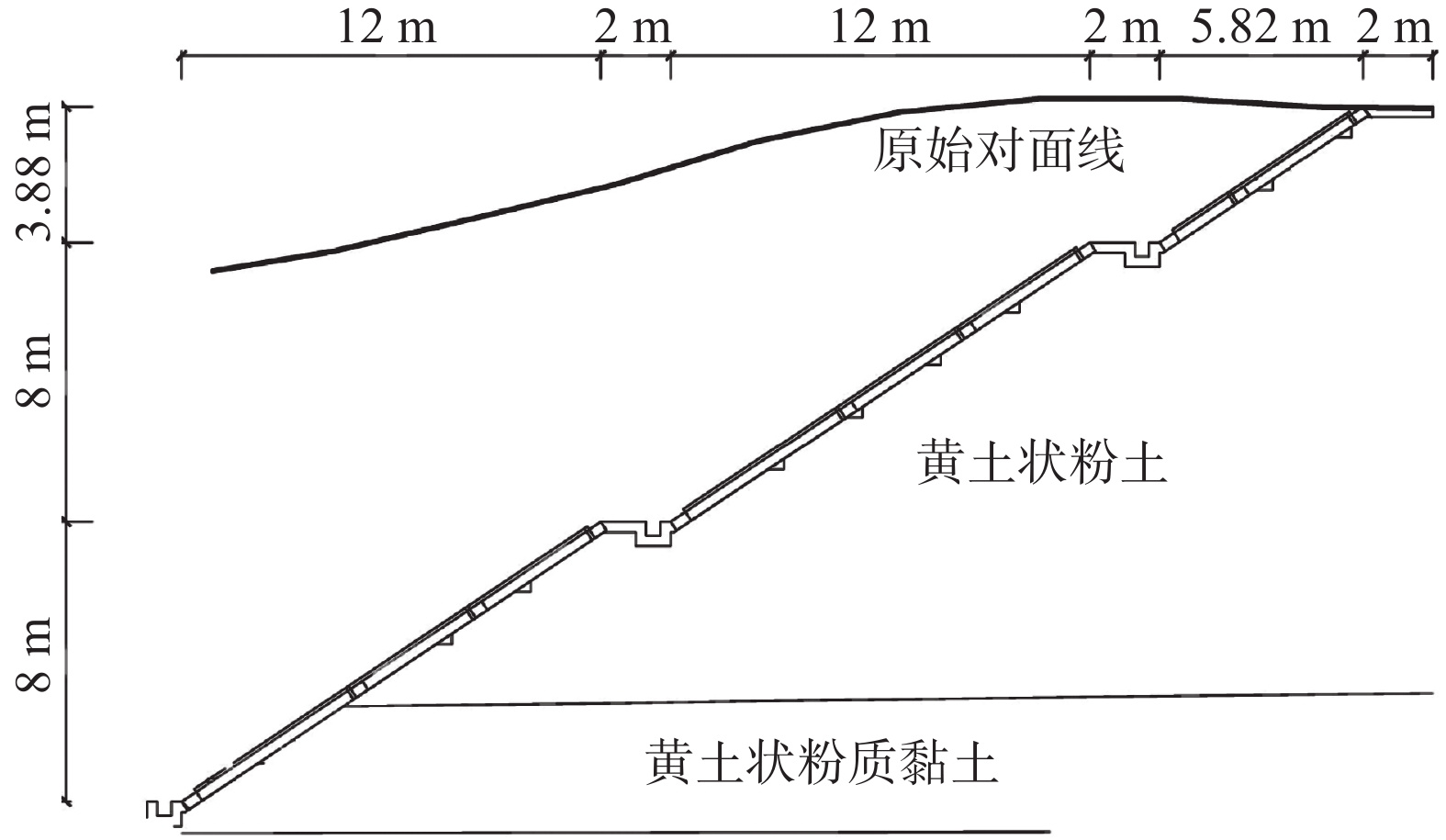
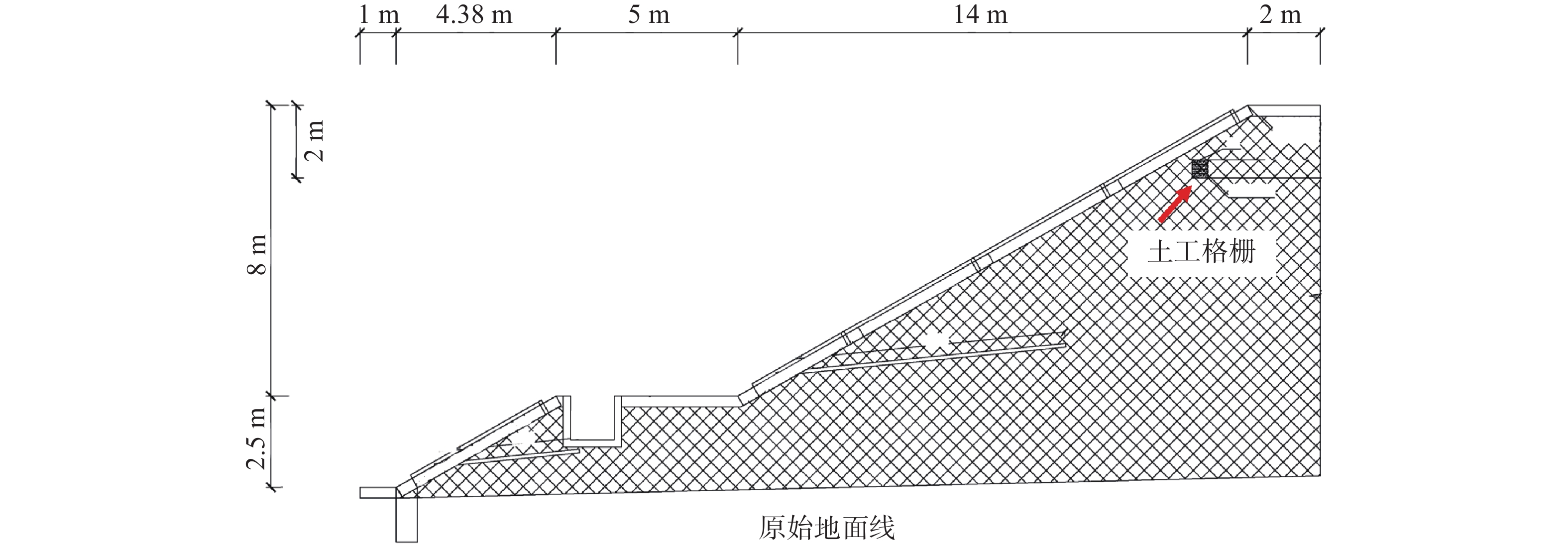
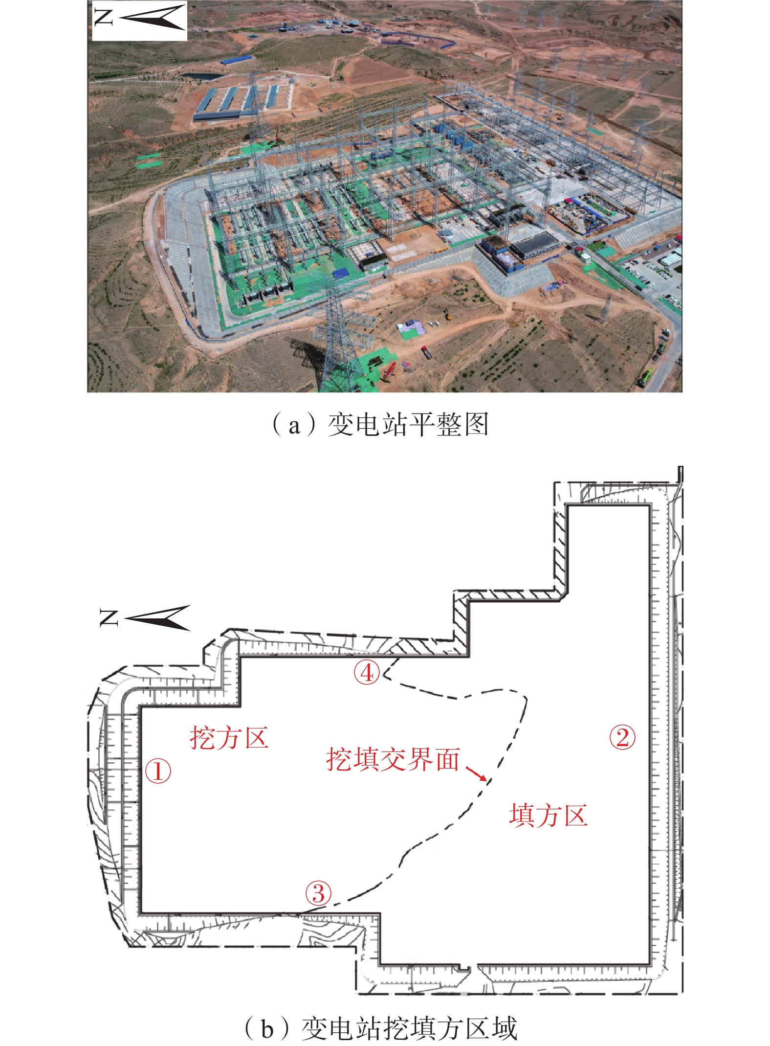
妙岭750 kV变电站工程位于宁夏回族自治区吴忠市同心县丁塘镇八方村,为新建工程,工程规模规划主变3×2 100 MVA。站址地貌单元属黄土丘陵边缘区,站区地势开阔,地形起伏大,整体地形呈北高南低,由北向南倾斜态势,站址范围内地面高程在1 429.77~1 459.77 m,最大高差约30 m,地表植被一般,修建前为荒地。在站址的南侧地段及西侧部分地段,将会形成新的填方边坡,最大高度约10余米,在施工质量不能保证、加固措施不力及雨水对坡脚冲刷、淘蚀等因素作用下,存在边坡失稳、滑塌等安全风险。由于地形坡度较大,变电站场地平整时形成挖填高边坡(图1),站址750 kV构架、750 kV电抗器等建筑物,基本位于挖方地段,最大挖方厚度约17 m,挖方区为变电站北侧;水工建筑物、主变器及330 kV构架等建筑群,位于填方地段,最大填方厚度约10 m,填方区为变电站南侧。场地整平后,形成一个由北向南微倾的台面,高差约3 m。
2. 探测方法选取
通过收集变电站工程资料和相关地形图解译,结合现场勘察结果,课题组确定该场地挖方区、填方区及挖填交界面位置。为研究边坡的安全稳定性,根据勘定的地形结果分别选择典型的挖填方边坡和挖填交界面进行探地雷达测试。将探地雷达测试结果与其它勘探资料结合起来进行综合分析研判,以提高探测准确性和精度。
2.1 探地雷达方法原理
探地雷达的工作原理是利用一个发射天线向下发射无线电波,另一个接收天线接收目标体的反射电磁波。因地下介质的电性差异,导致反射电磁波的差异性。可根据雷达图像的波形、振幅、双程走时等参数,解译地下目标体的空间位置、电性界面的形态、埋深和构造等特征信息,从而实现探测目的。在实际的地下探测中,天线沿着地面移动,脉冲信号不断地被发送和接收。目前常用的探地雷达测量方法有反射方式的剖面法、透射法、共中心点法和宽角法,剖面法是目前用途最广的方法。剖面法是发射天线和接收天线以固定间距沿线同步移动的一种测量方式,它的测量结果是用探地雷达剖面波谱图像来表示。该图像的横坐标记录了天线在地表的位置,纵坐标为反射波双程走时,表达雷达脉冲从发射天线出发经地下界面发射回到接收天线所需的时间[22]。天然地基的土层具有成层性,而挖填方施工可能会使天然土体发生下陷,并伴随产生裂缝等情况。因为各种土层的颗粒成分、组成、孔隙比、含水量等存在一定的差异,当电磁波遇到这些物性差异土层的界面时便发生反射,由反射波的特征可判断它们之间的层位和现象。
2.2 探测方案
探测仪器采用加拿大生产的pulseEKKO PRO探地雷达,天线频率为100 MHz,数据采集软件为Data Acquisition Programme。探地雷达主要测量参数设置为:时间窗口500 ns,天线间距1 m,采样点距0.5 m,叠加次数256。探测区包括:(1)挖方区高边坡,位于变电站围墙北侧,布设的测线长度为146 m;(2)填方区边坡,位于变电站围墙南侧,布设的测线长度为372 m;(3)挖填交界区域,位于变电站围墙西侧、东侧中部,西侧的测线长度为15 m,东侧的测线长度为20 m。图2是测线布置图,在现场探测过程中,通过观察控制面板中的实时波谱影像,确保试验顺利进行。
2.3 数据处理方法
采用探地雷达数据处理软件EKKO project对采集的数据进行处理来获得探地雷达波谱图像。由于探地雷达全通的记录方式,在记录各种有效波的同时,干扰也一并被记录下来;另外,地下介质的滤波器作用,也使得回波信号被吸收衰减,并随着深度的增加回波信号衰减很快。因此,为真正得到反映研究区域内结构层次、缺陷隐患等情况的图像,必须对深部信号增强和去除噪声,以改善数据质量。通过增益调适的数据处理方式,得到最佳的探地雷达图像,反映出清晰准确的有用信息。
3. 结果分析与讨论
探地雷达探测试验是在变电站初步建成后进行的,现场施工基本完成。通过变电站岩土工程勘察报告中勘察钻孔和探井揭露的地层信息,以及地质调查测绘结果,可知站址地层岩性、土质湿陷性等方面的内容。将探地雷达数据处理结果和勘察报告结合起来分析,可提高探测精度,使研究结果更具说服力。
3.1 高挖方边坡探测结果与分析
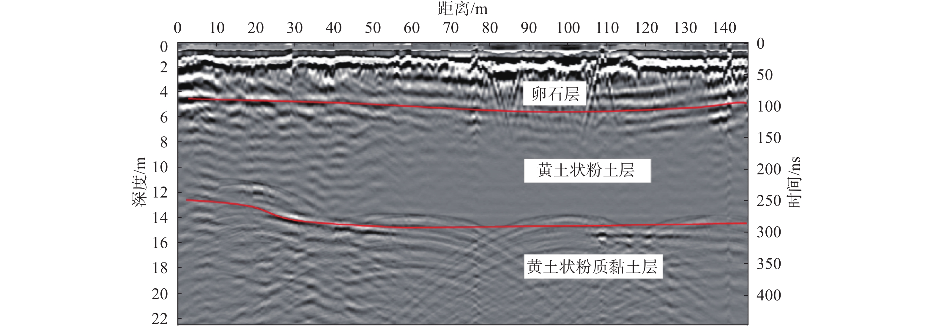
波谱图像的横坐标为测点距离,单位m;左侧纵坐标是深度坐标,单位m;右侧纵坐标为电磁波的双程走时,单位ns。图3是挖方边坡探地雷达波谱图,波谱图显示土层深度0~20 cm范围有反射波影像,通过施工方案可知,是边坡面层浇筑的混凝土,厚度约10 cm。在土层深度约0.2~4 m范围有较明显的分界线,反射波强烈,说明该界线上下介质的介电常数差异较大[23-24]。根据挖方边坡剖面图(图4)分析可知该土层深度范围是卵石层。卵石以密实居多,分选磨圆一般,呈次棱−次圆状,半胶结状,母岩成分主要为变质岩,次要为沉积岩,充填物以黏性土为主,少量砂类土。在卵石层中可见裂隙,该裂隙应是开挖过程中的卸荷裂隙。卸荷裂缝在一定程度上影响边坡安全稳定性,但开挖边坡发生在边坡上部区域,具有卸荷减载作用,使边坡稳定性增强。在土层深度约4~14 m,是不均匀的黄土状粉土夹粉砂土层,波谱图中能看到零星破碎带的反射波形。土体在胶结、半胶结状态下较坚硬,密实度高,区别于其它黄土,该情况下在波谱图中有强烈的反射波面。黏粉粒含量变化较大的黄土间,也有明显的反射波谱影像,因为黏粉粒含量影响电磁波信号[25]。在土层深度约14~22 m,有大规模双曲线不规则反射特征,说明该处是基岩顶部,其表现通常像是堆叠的双曲线[26]。地勘报告显示该土质较均匀,部分为黄土状粉土或黄土状黏土,可见层理,混砂粒、砾石颗粒,部分呈胶结状,土的密实程度较高。
总体而言,挖方边坡区域地层复杂、土体组成成分较多,密实度高,探地雷达波谱影像显示复杂,反射波形较多,反射信号强烈。挖方区边坡土性整体以黄土状粉土和黄土状粉质黏土为主,土层界线之间互呈渐变关系,薄夹层或透镜体、含混合物较多,岩性较杂乱,土质不均匀,普遍具有湿陷性。挖方区湿陷性黄土分布在站区北侧坡顶、坡面等地势相对较高地段,具非自重湿陷性。场地整平时,对于挖方区域全部消除或部分减少了湿陷土层厚度,湿陷量将随挖方厚度的增加明显减小或为无湿陷。挖方高边坡仍保留了原始地貌的土层性状,湿陷土层厚度较厚,厚度约8 m。但挖方边坡的黄土状粉土是非自重湿陷性黄土,土层浸水后在无外荷载作用下不会发生湿陷,边坡无上覆荷载,所以挖方边坡的安全性受湿陷性影响较小。土体结构的不均匀性、卸荷裂隙和潜在的软弱滑动面,影响挖方边坡的安全稳定性。挖方后的边坡,由于四季温度、干湿循环变化,土体性状随之发生变化,边坡稳定性也会发生周期性的变化。雨季时土体湿度增大、强度降低,会使得边坡局部区域处于不稳定状态[10]。
3.2 高填方边坡探测结果与分析
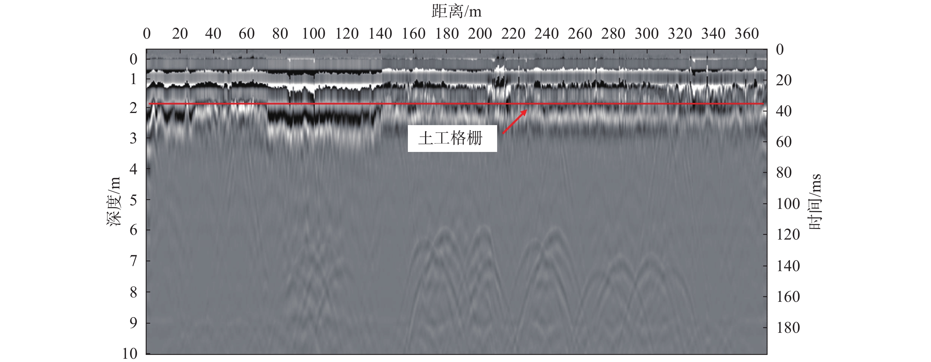
填方区边坡,取料是挖方区开挖的黄土,将过筛后的黄土每30 cm铺一层,利用压路机进行分层碾压夯实,使填方区压实系数不小于0.95。图5是填方边坡波谱图,土层深度0~20 cm有明显的反射波面,和挖方区边坡相同,此处是边坡混凝土砌护层。土层深度2 m处有强烈的反射波面,反映的是边坡中铺设的玻璃纤维土工格栅(图6),用砂袋交错码放进行反包。土工格栅的介电常数和黄土不同,故出现较强烈的平直反射波面。说明探地雷达图像结果能较好地反映土层内部特征。土层2~10 m无明显裂隙、局部沉陷等异常反射波形,说明土质均匀,填方边坡填土效果良好。
填方边坡土体和挖方边坡土体相比,填方边坡土体组成成分简单,土质均匀,密实度低,探地雷达波谱影像显示单一,反射信号弱。填方区下伏原始地形起伏较大,土体岩性种类多,主要有黄土状粉土、黄土状粉质黏土、粉质黏土、粉砂、卵石等不规则地分布于土体中,填土厚薄不均匀,施工后易产生不均匀沉降和变形;主要持力层其层位埋深和厚度在水平和竖直方向上亦存在一定差异。变电站是初建工程,填方边坡填土后上部荷重增加,形成的回填压实黄土具有压缩性,产生较大的沉降量,且下沉完成需要较长时间,下沉对边坡治理产生不利影响。填方土体厚度是决定地面沉降分布与大小的主要控制因素,填方土体厚度越大,地面沉降现象越显著[27-29]。对于填方边坡建议长期监测,回填土若处理不彻底,填土将会重新固结,导致边坡土体发生局部的不均匀沉降。边坡的下伏土层岩性不均匀,工程性能差异明显,填土增加的上覆荷载可能会使原始土层发生下陷、开裂等不良现象。填方土体经碾压夯实,已无湿陷性,但该区域下伏的原始地形中的黄土状粉土是自重湿陷性黄土。填方区填土厚度最大约10余米,随着回填厚度的增加,在上覆填土自重压力的作用下,存在湿陷性加大及湿陷下限加深的可能。对于湿陷性黄土地区已有高填方工程经验表明,影响安全稳定性的因素复杂,情况差别大,工后沉降较大,历时长,对整个工程造成安全威胁[1]。
3.3 挖填交界区域探测结果与分析
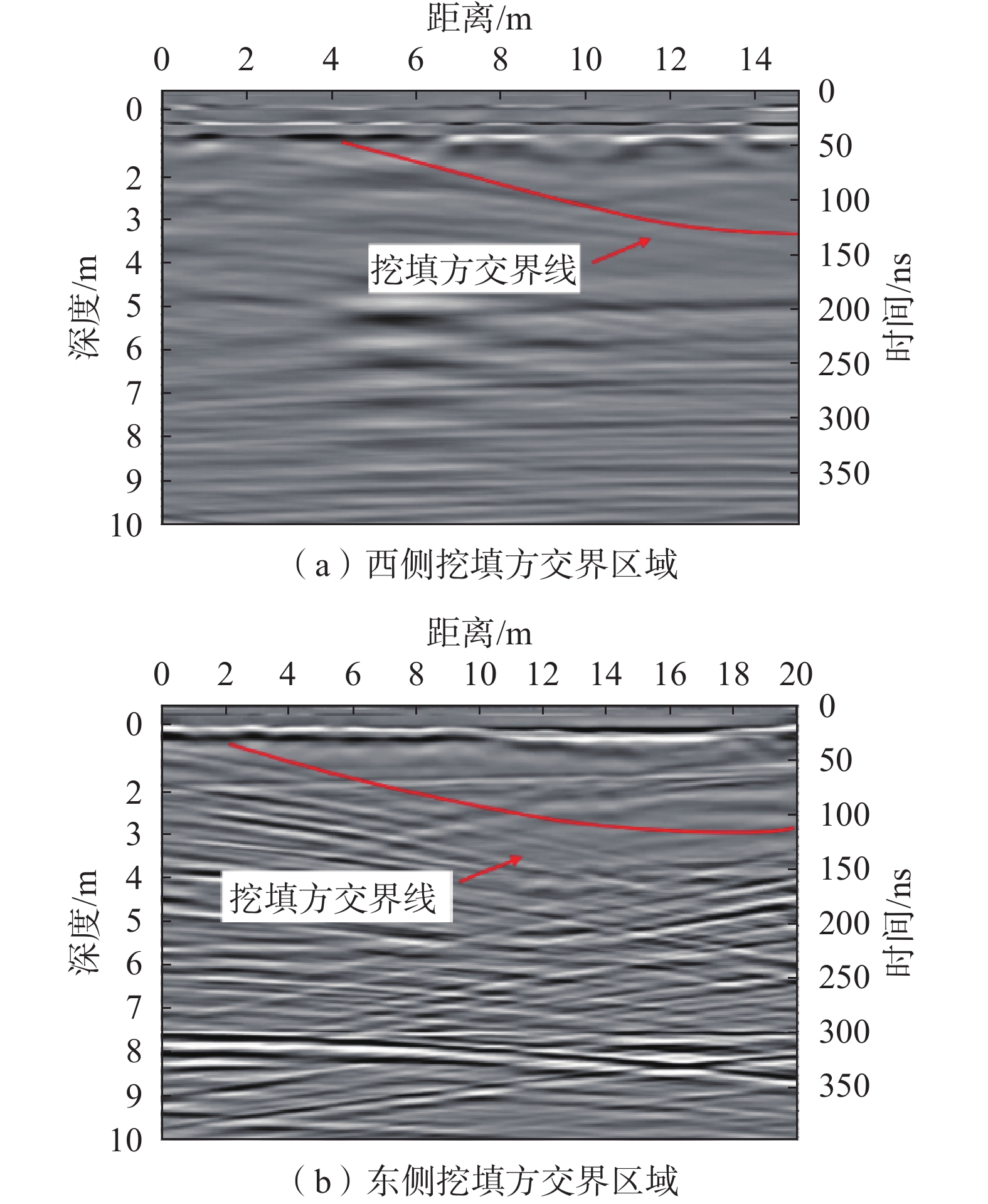
图7是变电站场地挖填交界区域的波谱图像,其中图7(a)是西侧挖填交界区的波谱图,图7(b)是东侧挖填交界区的波谱图。从图7(a)可以看出,土层深度0~50 cm处有明显的反射波影像,说明该界面上下介质的介电常数差异大,施工报告显示,该处是道路的混凝土面层,厚度约40 cm。土层深度50~100 cm处出现显著的破碎带,该破碎带是铺设的厚度约30 cm的砂夹石层。表明探地雷达探测效果良好,能较准确的体现出地层特征。图7(b)中土层深度0~20 cm处有反射波面,该处是厚度约为10 cm的混凝土面层,道路的混凝土面层经过两次浇筑,面层厚度大于其它区域的面层厚度。面层下方是挖方后原始土体和填方土体的交界区域。因挖方、填方土体的密实度不同,组成成分不同,探地雷达在挖方区探测波形复杂,填方区单一,波谱图能显示出挖填交界线。图7为挖方区、填方区的波谱特征图,图7(a)土层深度100 cm以上和图7(b)土层深度20 cm以上有挖填交界线的波谱影像显示。根据图中曲线可以看出填方区填土深度逐渐增加,西侧的填土深度范围是0~3.2 m,东侧的填土深度范围是0~2.5 m,挖方区坡度较缓,这保证了挖填方交界区均匀过渡。
但变电站场地高差大,场地整平后,填方区域填土厚度变化大,填方区沉降变形对填挖交界面土体有扰动作用,可导致挖填交界薄弱面出现裂隙、滑移等现象。回填土压缩模量小,在荷载作用下变形比挖方区原状土大,而原状土上部卸荷后,局部会产生回弹,因此填方区与挖方区会产生相对滑移,挖填方之间的约束阻力减小,弱化挖填方界面土体的强度。挖填交界面是填方施工过程中人为创造的不利结构面,是边坡失稳的潜在破坏面[6]。原始土体和填方土体压实度不同,原始土体更坚硬密实,填方土体施工后短期固结度差,引起的横向不均匀性使地表水易沿挖填交界面渗入,填土强度降低,形成软弱带,进一步的恶化发展可能导致填方区域沿挖填界面整体失稳。挖、填方土性的差异性导致不均匀沉降,挖填界面附近常会因差异沉降而出现开裂现象。挖填方交界区域是浅挖方区域、浅填方区域之间的过渡段,地基土按非自重湿陷性黄土场地考虑。但变电站场地具有高填方、建设环境复杂、相互影响因素多等特点,在水和外部荷载作用下易导致土体湿陷变形,造成地基土的不均匀沉降甚至边坡失稳。挖填交界区域安全稳定性受黄土湿陷性影响较大,若处理不当,势必影响挖填边坡的强度和耐久性。
4. 结论
采用pulseEKKO PRO专业型探地雷达对妙岭变电站湿陷性黄土高边坡挖、填方区域及其交界面进行探测,并结合工程勘察报告对探测结果的分析与讨论,得到如下结论:
(1)波谱特征图像和地勘报告相同位置处土层分布一致,且能反映出边坡表面的混凝土砌护、边坡内部土工格栅的位置以及土层性状,说明探地雷达适用于高挖、填方边坡及其交界面的探测,能较清楚地显示出边坡内部构造。
(2)挖方区域波谱影像复杂,反射波形较紊乱,强烈反射波形多,结合工程勘察报告判断出该区域存在卸荷裂隙、零星破碎带和潜在的软弱滑动面等现象,整体土质不均匀、密实度高,但没有空洞、断层等严重不良地质现象的反射波形显示。
(3)填方区域波谱影像显示单一,反射波形较均匀,没有明显裂缝、局部沉陷等异常反射波面,判断出填方区域填土均匀,土体密实度相对较低。根据工程勘察报告可知该区域填土厚度大,土体经碾压夯实已无湿陷性,但其下伏土体是自重湿陷性黄土,所以该边坡稳定性主要受不均匀沉降、下伏黄土湿陷性的影响。
(4)挖、填交界区域两侧波谱图波形显示不同,挖方区域是原始地形,探测波形复杂,填方区域是人工填土,探测波形规则,挖填之间形成明显的分界线。挖填分界线虽坡度较缓,过渡均匀,但易受填方区沉降变形、湿陷性等不利干扰,是边坡失稳的潜在破坏面。挖填方土性的差异性易导致土体的不均匀沉降,整体稳定性相对较差,应予以重视。
-
[1] 张茂省,谭新平,董英,等. 黄土高原平山造地工程环境效应浅析—以延安新区为例[J]. 地质论评,2019,65(6):1409 − 1421. [ZHANG Maosheng,TAN Xinping,DONG Ying,et al. Initial analysis on environmental effect of cutting hills to backfill ditch project on Loess Plateau:Take Yan’an New District as an example[J]. Geological Review,2019,65(6):1409 − 1421. (in Chinese with English abstract) DOI: 10.16509/j.georeview.2019.06.008 [2] 刘琨,卢育霞,徐舜华. 黄土丘陵沟壑区挖填场地动力响应特征研究[J]. 防灾减灾工程学报,2021,41(5):1096 − 1104. [LIU Kun,LU Yuxia,XU Shunhua. Study on characteristics of dynamic response at digging-filling sites in the loess hilly and gully region[J]. Journal of Disaster Prevention and Mitigation Engineering,2021,41(5):1096 − 1104. (in Chinese with English abstract) DOI: 10.13409/j.cnki.jdpme.201908017 [3] 黄伟杰, 蔡军君, 熊翠红. 净值分析在电力工程进度控制中的应用—以某1000 kV变电站为例[J]. 武汉大学学报(工学版), 2018, 51(增刊1): 387 − 392 HUANG Weijie, CAI Junjun, XIONG Cuihong. Application of earned value analysis to electric power construction schedule control: Take a 1 000 kV substation as an example[J]. Engineering Journal of Wuhan University, 2018, 51(Sup 1): 387 − 392. (in Chinese with English abstract)
[4] 蔺晓燕, 杨泽, 李萍, 等. 地层划分对黄土高边坡稳定性分析的影响研究[J]. 岩土工程学报, 2021, 43(增刊1): 76 − 80 LIN Xiaoyan, YANG Ze, LI Ping, et al. Effects of stratigraphic division on stability analysis of high loess slopes[J]. Chinese Journal of Geotechnical Engineering, 2021, 43(Sup 1): 76 − 80. (in Chinese with English abstract)
[5] 孔令伟,陈正汉. 特殊土与边坡技术发展综述[J]. 土木工程学报,2012,45(5):141 − 161. [KONG Lingwei,CHEN Zhenghan. Advancement in the techniques for special soils and slopes[J]. China Civil Engineering Journal,2012,45(5):141 − 161. (in Chinese with English abstract) [6] 龚伟翔, 张晓超, 裴向军, 等. 基于高陡交填界面软弱带影响下黄土填方边坡失稳模式研究[J/OL]. 工程地质学报: 1 − 11(2021-5-13)[2021-10-23] GONG Weixiang, ZHANG Xiaochao, PEI Xiangjun, et al. Study on the instability model of loess filled slope based on the influence of weak zone of high and steep filling interface[J/OL]. Journal of Engineering Geology: 1 − 11(2021-5-13)[2021-10-23]. (in Chinese with English abstract)
[7] 毛洪运,朱江鸿,喻小,等. 强夯法消除风积粉细砂湿陷性研究[J]. 工程地质学报,2019,27(4):745 − 752. [MAO Hongyun,ZHU Jianghong,YU Xiao,et al. Dynamic compaction study of eliminating the collapsibility of eolian deposit fine sand[J]. Journal of Engineering Geology,2019,27(4):745 − 752. (in Chinese with English abstract) DOI: 10.13544/j.cnki.jeg.2018-113 [8] 毛正君,张瑾鸽,仲佳鑫,等. 梯田型黄土滑坡隐患发育特征与成因分析—以宁夏南部黄土丘陵区为例[J]. 中国地质灾害与防治学报,2022,33(6):142 − 152. [MAO Zhengjun,ZHANG Jinge,ZHONG Jiaxin,et al. Analysis of basic characteristics and deformation mechanism of loess potential landslide of terrace: Taking loess hilly region in southern Ningxia as an example[J]. The Chinese Journal of Geological Hazard and Control,2022,33(6):142 − 152. (in Chinese with English abstract) [9] 马闫,王家鼎,彭淑君,等. 黄土贴坡高填方变形破坏机制研究[J]. 岩土工程学报,2016,38(3):518 − 528. [MA Yan,WANG Jiading,PENG Shujun,et al. Deformation and failure mechanism of high sticking loess slope[J]. Chinese Journal of Geotechnical Engineering,2016,38(3):518 − 528. (in Chinese with English abstract) DOI: 10.11779/CJGE201603016 [10] 蒲小武,王兰民,吴志坚,等. 兰州丘陵沟壑区挖方黄土高边坡面临的工程地质问题及稳定性分析[J]. 地震工程学报,2016,38(5):787 − 794. [PU Xiaowu,WANG Lanmin,WU Zhijian,et al. Engineering geological problems of loess high excavation slope in loess hilly and gully region of Lanzhou and its stability analysis[J]. China Earthquake Engineering Journal,2016,38(5):787 − 794. (in Chinese with English abstract) DOI: 10.3969/j.issn.1000-0844.2016.05.0787 [11] 吕远强,董转运. 公路黄土路堑、路堤的湿陷性评价分析[J]. 工程勘察,2010,38(9):28 − 31. [LYU Yuanqiang,DONG Zhuanyun. Analysis of appraisement collapsibility on loess embankment and cutting of road[J]. Geotechnical Investigation & Surveying,2010,38(9):28 − 31. (in Chinese with English abstract) [12] 梁小龙,王建业,白泽朝,等. 基于PS-InSAR技术的黄土大厚度挖方区回弹变形规律分析[J]. 测绘通报,2020(3):163 − 166. [LIANG Xiaolong,WANG Jianye,BAI Zechao,et al. Research on rebound deformation using PS-InSAR technology in loess plateau area[J]. Bulletin of Surveying and Mapping,2020(3):163 − 166. (in Chinese with English abstract) [13] WANG J D,XU Y J,MA Y,et al. Study on the deformation and failure modes of filling slope in loess filling engineering:A case study at a loess mountain airport[J]. Landslides,2018,15(12):2423 − 2435. DOI: 10.1007/s10346-018-1046-5
[14] 江丽,吴栋,李春林,等. 地质雷达在边坡稳定性检测和预警中的应用[J]. 人民长江,2012,43(5):51 − 53. [JIANG Li,WU Dong,LI Chunlin,et al. Application of GPR in slope stability monitoring and pre-warning[J]. Yangtze River,2012,43(5):51 − 53. (in Chinese with English abstract) DOI: 10.3969/j.issn.1001-4179.2012.05.012 [15] STEELMAN C M,KENNEDY C S,PARKER B L. Geophysical conceptualization of a fractured sedimentary bedrock riverbed using ground-penetrating radar and induced electrical conductivity[J]. Journal of Hydrology,2015,521:433 − 446. DOI: 10.1016/j.jhydrol.2014.12.001
[16] ZAJC M,POGAČNIK Ž,GOSAR A. Ground penetrating radar and structural geological mapping investigation of Karst and tectonic features in flyschoid rocks as geological hazard for exploitation[J]. International Journal of Rock Mechanics and Mining Sciences,2014,67:78 − 87. DOI: 10.1016/j.ijrmms.2014.01.011
[17] ZHANG J,LIN H,DOOLITTLE J. Soil layering and preferential flow impacts on seasonal changes of GPR signals in two contrasting soils[J]. Geoderma,2014,213:560 − 569. DOI: 10.1016/j.geoderma.2013.08.035
[18] 蒲虹宇,张立峰,何毅,等. 甘肃通渭黄土滑坡二维形变时序监测[J]. 中国地质灾害与防治学报,2022,33(6):114 − 124. [PU Hongyu,ZHANG Lifeng,HE Yi,et al. Time-series monitoring of two-dimensional deformation of Tongwei loess landslide in Gansu Province[J]. The Chinese Journal of Geological Hazard and Control,2022,33(6):114 − 124. (in Chinese with English abstract) [19] 王永强,曹竹,谭钦文,等. 露天矿滑坡体的探地雷达检测技术[J]. 煤炭学报,2011,36(7):1093 − 1097. [WANG Yongqiang,CAO Zhu,TAN Qinwen,et al. GPR detection of open-pit landslide[J]. Journal of China Coal Society,2011,36(7):1093 − 1097. (in Chinese with English abstract) DOI: 10.13225/j.cnki.jccs.2011.07.028 [20] XIE P,WEN H J,XIAO P,et al. Evaluation of ground-penetrating radar (GPR) and geology survey for slope stability study in mantled Karst region[J]. Environmental Earth Sciences,2018,77(4):122. DOI: 10.1007/s12665-018-7306-9
[21] HAN X L,LIU J T,ZHANG J,et al. Identifying soil structure along headwater hillslopes using ground penetrating radar based technique[J]. Journal of Mountain Science,2016,13(3):405 − 415. DOI: 10.1007/s11629-014-3279-7
[22] 程久龙,潘冬明,李伟,等. 强电磁干扰区灾害性采空区探地雷达精细探测研究[J]. 煤炭学报,2010,35(2):227 − 231. [CHENG Jiulong,PAN Dongming,LI Wei,et al. Study on the detecting of hazard abandoned workings by ground penetrating radar on strong electromagnetic interference area[J]. Journal of China Coal Society,2010,35(2):227 − 231. (in Chinese with English abstract) [23] 王韵,王红雨,常留成,等. 基于探地雷达的水库坝前淤积土沉积规律研究[J]. 水土保持学报,2021,35(4):152 − 158. [WANG Yun,WANG Hongyu,CHANG Liucheng,et al. Study on sedimentation regulation of silted soil in the front of reservoir dam based on GPR[J]. Journal of Soil and Water Conservation,2021,35(4):152 − 158. (in Chinese with English abstract) [24] 蔡少峰. 探地雷达在河流水下地形及基岩探测中的试验研究[J]. 工程地球物理学报,2019,16(5):680 − 685. [CAI Shaofeng. The experimental study on ground penetrating radar in underwater topography and bedrock detection[J]. Chinese Journal of Engineering Geophysics,2019,16(5):680 − 685. (in Chinese with English abstract) DOI: 10.3969/j.issn.1672-7940.2019.05.021 [25] 李勉,杨二,李平,等. 黄土丘陵区小流域淤地坝泥沙沉积特征[J]. 农业工程学报,2017,33(3):161 − 167. [LI Mian,YANG Er,LI Ping,et al. Characteristics of sediment deposition in check dam in small watershed in Loess Hilly Area[J]. Transactions of the Chinese Society of Agricultural Engineering,2017,33(3):161 − 167. (in Chinese with English abstract) DOI: 10.11975/j.issn.1002-6819.2017.03.022 [26] JOL H M,BRISTOW C S. GPR in sediments:Advice on data collection,basic processing and interpretation,a good practice Guide[J]. Geological Society,London,Special Publications,2003,211(1):9 − 27. DOI: 10.1144/GSL.SP.2001.211.01.02
[27] 蒲川豪,许强,赵宽耀,等. 基于遥感分析的延安新区平山造城工程地面沉降及植被恢复特征研究[J]. 工程地质学报,2020,28(3):597 − 609. [PU Chuanhao,XU Qiang,ZHAO Kuanyao,et al. Remote sensing analysis of land subsidence and vegetation restoration characteristics in excavation and filling areas of mountain region for urban extension in Yan'an[J]. Journal of Engineering Geology,2020,28(3):597 − 609. (in Chinese with English abstract) [28] 骆祖江, 成磊, 张兴旺, 等. 悬挂式止水帷幕深基坑降水方案模拟优化[J]. 吉林大学学报(地球科学版),2022,52(6):1946 − 1956. [LUO Zujiang, CHENG Lei, ZHANG Xingwang, et al. Simulation and optimization of dewatering scheme for suspended impervious curtain in deep foundation pit[J]. Journal of Jilin University (Earth Science Edition),2022,52(6):1946 − 1956. (in Chinese with English abstract) [29] 秦胜伍,张延庆,张领帅,等. 基于Stacking模型融合的深基坑地面沉降预测[J]. 吉林大学学报(地球科学版),2021,51(5):1316 − 1323. [QIN Shengwu,ZHANG Yanqing,ZHANG Lingshuai,et al. Prediction of ground settlement around deep foundation pit based on stacking model fusion[J]. Journal of Jilin University (Earth Science Edition),2021,51(5):1316 − 1323. (in Chinese with English abstract) -
期刊类型引用(1)
1. 苏娜,徐林荣,李永威,李佳珅,汤玉兰. 汶川地震震后七盘沟泥石流动态物源危险性评价. 中国地质灾害与防治学报. 2025(01): 16-27 .  本站查看
本站查看
其他类型引用(0)
 下载:
下载:

计量
- 文章访问数: 5609
- HTML全文浏览量: 2217
- PDF下载量: 621
- 被引次数: 1
 邮件订阅
邮件订阅 RSS
RSS