

Geological hazard assessment based on the models of AHP, catastrophe theory and their combination: A case study in Pingshan County of Hebei Province
-
摘要:
河北平山县受地形地貌、地质构造和生态环境等因素的影响,崩滑流等地质灾害频发。选取地形起伏度、坡度、坡向、河网密度、断裂带密度、地层岩性、NDVI、土地利用类型及地质灾害点密度9个评价因子,用AHP和突变理论分别求各评价因子权重,并按最小信息熵权法结合,建立AHP-突变理论组合模型并应用,对比基于三种方法的平山县地质灾害危险性评价结果。结果表明:组合模型的评价结果精度更高,符合该区地质灾害发育特征;组合模型法将主客观结合,综合考虑因子的影响,评价结果可靠。该研究为平山县及类似地区地质灾害危险性评价提供一种新的尝试和方法。
Abstract:Pingshan County, Hebei was affected by topography, geological structure, ecological environment and other factors, geological disasters such as landslides occurred frequently. Nine evaluation factors including topographic relief, slope, aspect, river network density, fault zone density, stratigraphic lithology, NDVI, land use type and geological disaster point density were selected. The weights of each evaluation factor were calculated by AHP and catastrophe theory, and the combination model of AHP and catastrophe theory was established and applied according to the minimum information entropy weight method. The results of geological disaster risk assessment in Pingshan County based on three methods were compared. The results show that the evaluation results of the combined model have higher accuracy and are in line with the development characteristics of geological disasters in this area. Combined model method combines subjective and objective, considering the influence of factors, the evaluation results are reliable. This study provides a new attempt and method for geological disaster risk assessment in Pingshan County and similar areas.
-
0. 引言
滑坡、崩塌灾害是地质灾害中的重要灾种,对社会经济、生命财产、地理环境都产生了重要影响[1]。贵州是地质灾害高发易发地区,常见诱发因素主要为降雨[2]。因此,研究地质灾害气象风险预警方法,对地质灾害防治具有重要作用。研究者对该领域进行了很多研究。文献[3]应用GIS数据处理功能,分析地质灾害区域的工程地质,针对复杂地质的地理环境,绘制出各气象风险等级下区域地质灾害分布图,但该方法对气象因素提取不全面,造成气象风险预警等级整体偏高。文献[4]分析气象环境与降水量之间的规律性,包括降雨阈值和临界降雨量等,通过地质灾害调查统计,综合评价气象风险,但该方法对降雨量的相关性分析较差,划分的气象风险预警等级同样较高。
针对以上问题,提出基于机器学习的滑坡、崩塌灾害气象风险预警方法。借助机器学习算法中人工神经网络实现贵州省滑坡、崩塌灾害气象风险预警方法的研究。实验结果表明:采用设计方法有效降低了滑坡、崩塌三级、四级预警空报率,提升了预警精细化程度。
1. 贵州省滑坡、崩塌灾害气象风险预警方法设计
1.1 气象因素对滑坡、崩塌灾害影响程度计算
为实现贵州省滑坡、崩塌灾害气象风险预警,需要提取贵州省滑坡、崩塌灾害相关气象因素,计算气象因素对滑坡、崩塌灾害的影响程度。汇总贵州省各区域的地质灾害详细调查报告、气象局实测降雨量数据,采用资料查阅、实地访问调查等方式,以月报形式统计气象引发灾害事件,同时综合考虑GPS、天气雷达、闪电定位、自动雨量站等数据来源,采集非常规观测资料,获取灾害隐患点数据和灾害易发分区数据。筛选与滑坡、崩塌灾害相关的气象因素。将滑坡、崩塌灾害的发生看作气象因素和下垫面相互作用结果。其中,气象因素主要为降水,包括降雨诱发作用、降雨滞后作用等因素。利用信息量法,客观反映预警单元的地质条件,分析气象因素对滑坡、崩塌灾害提供的信息量[5]。计算气象因素和地质灾害的相关函数
(1) 式中:
(2) 将整个贵州省区域划分为单元网格,利用频率统计,估算条件概率
(3) 式中:
通过总信息量值,定量分析气象因素对地质灾害的影响程度,
1.2 地质灾害发生的判断
在确定气象因素对地质灾害影响程度基础上,利用机器学习中的人工神经网络,判断贵州省各区域是否发生地质灾害。首先,参照采集地质环境数据,结合岩性特征、地形地貌、以及气候条件因素,对贵州省各区域进行条件比较,利用GIS空间分析功能,定量划分贵州省地质灾害易发生区,并明确其易发生等级[9]。划分结果见图1。
![]() 图 1 贵州省地质灾害易发区分布示意图Figure 1. Distribution of geological disaster-prone areas in Guizhou Province
图 1 贵州省地质灾害易发区分布示意图Figure 1. Distribution of geological disaster-prone areas in Guizhou Province根据贵州省近20年历史降雨量数据,以及记录的滑坡、崩塌灾害数据,明确各区域的降雨量数据,包含当日临界雨量和5日临界雨量。同时,根据滑坡、崩塌灾害野外调查结果,对临界雨量值进行适当调整,以此减小历史统计数据误差[10]。最后,将预报区域中易发生区等级、实际降雨量、坐标点X坐标和Y坐标,作为机器学习的人工神经网络4个输入节点,利用线性函数,激活神经网络的输入层和输出层,再利用Sigmoid函数,激活隐含层,输入前对数据进行归一化处理,使各数据处于同等水平,消除量纲影响,避开Sigmoid函数训练数据的饱和区[11]。神经网络结构见图2。
![]() 图 2 滑坡、崩塌灾害机器学习神经网络结构Figure 2. Structure of machine learning neural network for geological disasters
图 2 滑坡、崩塌灾害机器学习神经网络结构Figure 2. Structure of machine learning neural network for geological disasters图2中,设置网络误差收敛到最小时,其相对应的隐含层节点数为4,将滑坡、崩塌灾害性发生可能性,作为神经网络的1个输出节点。根据机器学习输出结果,判定坐标点区域是否发生滑坡、崩塌灾害,完成滑坡、崩塌灾害发生的判断。
1.3 滑坡、崩塌灾害气象风险等级划分
针对贵州省滑坡、崩塌灾害发生区域,根据气象因素影响程度,计算气象引发因子指数,结合该区域的地质灾害潜势度、承灾体脆弱性,划分气象风险的预警等级。
对预警区域进行单元编号,计算单元区域
(4) 式中:
计算单元区域
(5) 式中:
计算滑坡、崩塌灾害潜势度
(6) 式中:
采用评价指标方式,在承灾体范围内,提取一级指标和二级指标,计算承灾体脆弱性
(7) 式中:
气象风险可概化公式为:
(8) 其中,
累积降水
/mm预报小雨
0.01~10预报中雨
10~25预报大雨
25~50预报暴雨
50~100预报大暴雨
≥100≤30 蓝色 黄色 橙色 红色 30~50 蓝色 黄色 橙色 红色 红色 50~100 黄色 橙色 红色 红色 红色 ≥100 橙色 红色 红色 红色 红色 表 2 滑坡、崩塌灾害中易发区气象风险预警级别Table 2. Warning level of meteorological risk in areas prone to geological disasters累积降水
/mm预报小雨
0.01~10预报中雨
10~25预报大雨
25~50预报暴雨
50~100预报大暴雨
≥100≤30 蓝色 黄色 橙色 30~50 蓝色 黄色 橙色 红色 50~100 蓝色 黄色 橙色 红色 红色 ≥100 黄色 橙色 红色 红色 红色 表 3 滑坡、崩塌灾害低易发区气象风险预警级别Table 3. Early warning level of meteorological risk in low areas prone to geological disasters累积降水
/mm预报小雨
0.01~10预报中雨
10~25预报大雨
25~50预报暴雨
50~100预报大暴雨
≥100≤30 蓝色 黄色 30~50 蓝色 黄色 橙色 50~100 蓝色 黄色 橙色 红色 ≥100 蓝色 黄色 橙色 红色 红色 注:其中预报降水为24 h预报降雨量,累积降水为最近五天累计降雨量。 在滑坡、崩塌灾害气象风险预警级别中,滑坡、崩塌灾害气象风险预警的等级为:
(1)蓝色预警(一级):有一定风险,关注降雨;
(2)黄色预警(二级):风险较高,关注降雨,做好监控;
(3)橙色预警(三级):风险高,注意降雨,做好监控及应急准备;
(4)红色预警(四级):风险很高,注意降雨,做好监控与应急撤离准备。
将气象风险预警指数
2. 实验分析
选取两种常规滑坡、崩塌灾害气象风险预警方法,与此次设计方法进行对比实验,比较各预警等级的空报率大小。
2.1 实验准备
将滑坡、崩塌灾害,作为贵州省地质灾害研究范围,采集降雨量数据和地质灾害数据,作为实验数据源,在样本中剔除不符合降雨诱发地质灾害个例、以及不匹配区域站降雨资料的降雨量数据。其降雨量历史信息见图3。
各区域的当日临界雨量和5日临界雨量,其各级预警的具体数值见表4。
表 4 贵州省当日临界雨量和5日临界雨量Table 4. Critical rainfall and mm rainfall of 5 th Day of Guizhou Province灾害易发区域 一级 二级 三级 四级 当日临界雨量
/m不易发区 92 55 37 28 低易发区 110 67 45 34 中易发区 132 79 53 40 高易发区 254 151 101 76 5日临界雨量
/m不易发区 223 133 89 67 低易发区 243 157 103 77 中易发区 262 157 105 79 高易发区 304 181 121 91 统计可得2014—2020年之间,贵州省地质灾害共发生1204处,发生地质灾害具体数据见表5。
表 5 贵州省典型地质灾害统计数据Table 5. Statistical data of typical geological disasters in Guizhou Province灾害点类型 灾害点数量/个 分布市镇数量/个 占灾害点总数比例/% 滑坡 1032 58 85.7% 崩塌 111 19 9.2% 泥石流 29 12 2.4% 地面塌陷 25 8 2.1% 地裂缝 7 3 0.5% 可见滑坡、崩塌占灾害总数的94.9%,三组预警方法分别根据以上历史数据中的滑坡、崩塌灾害,对贵州省地质灾害气象风险进行预警,并以2020年地质灾害作为参照,对比检验三组预警结果。
2.2 实验结果
2.2.1 崩塌灾害空报率测试结果
2020年崩塌灾害隐患点数量共29处,三组方法均可准确预测出该类地质灾害,其预警等级见图4。
由图4可知,两组常规方法三级预报数量和四级预警数量要明显多于设计方法,隐患点崩塌预警的严重程度整体偏高。进一步统计所有年份中,各预警级别的空报率,实验对比结果见表6。
表 6 崩塌预警空报率Table 6. Empty reporting rate of collapse early warning and forecast设计方法 常规方法1 常规方法2 一级预报/% 0 0 0 二级预报/% 0 0 0 三级预报/% 8.27 14.92 17.92 四级预警/% 7.26 13.29 19.26 由表6可知,相比常规方法1和常规方法2,设计方法对崩塌的三级预报空报率分别降低了6.65%和9.65%,四级预警空报率分别降低了6.03%和12.0%。
2.2.2 滑坡灾害空报率测试结果
2020年滑坡灾害隐患点数量共33处,三组方法都准确预测出该类地质灾害,其预警等级见图5。
由图5可知,针对滑坡这一地质灾害,两组常规方法的三级预警数量和四级预警数量,同样多于设计方法,隐患点预警的严重程度仍整体偏高。进一步统计所有年份中,各预警级别的空报率,实验对比结果见表7。
表 7 滑坡预警空报率Table 7. Empty reporting rate of landslide early warning and forecast设计方法 常规方法1 常规方法2 一级预报/% 0 0 0 二级预报/% 0 0 1.21 三级预报/% 9.92 14.96 16.92 四级预警/% 6.12 14.63 17.29 由表7可知,相比常规方法1和常规方法2,设计方法对滑坡的三级预警空报率分别降低了5.04%和7%,四级预警空报率分别降低了8.51%和11.17%,且常规方法2的二级预警仍存在空报率。
3. 结论
针对现有滑坡、崩塌地质灾害预警方法中存在的不足,本文提出采用机器学习算法对地质灾害气象风险进行预警的方法。
(1)该方法通过采用机器学习神经网络中节点的输入,有效预测地质灾害发生。
(2)采用设计方法与常规方法对比中,本文方法对崩塌预警的三级预报空报率分别降低了5.04%和7%,四级预警空报率分别降低了8.51%和11.17%;对滑坡预警的空报率中,三级预报空报率分别降低了5.04%和7%,四级预警空报率分别降低了8.51%和11.17%,验证了本文方法适用于贵州省滑坡、崩塌灾害气象风险预警。
但此次研究仍存在一定不足,在今后研究中,会持续验证每年实际发生的地质灾害,修正该模型,进一步提高地质灾害预警精度。
-
![]()
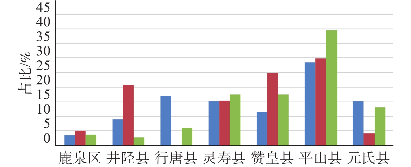
图 2 石家庄市崩滑流地质灾害隐患点分布
Figure 2. Distribution of potential and geological hazard points of collapse, landslide and debris flow in Shijiazhuang
![]()
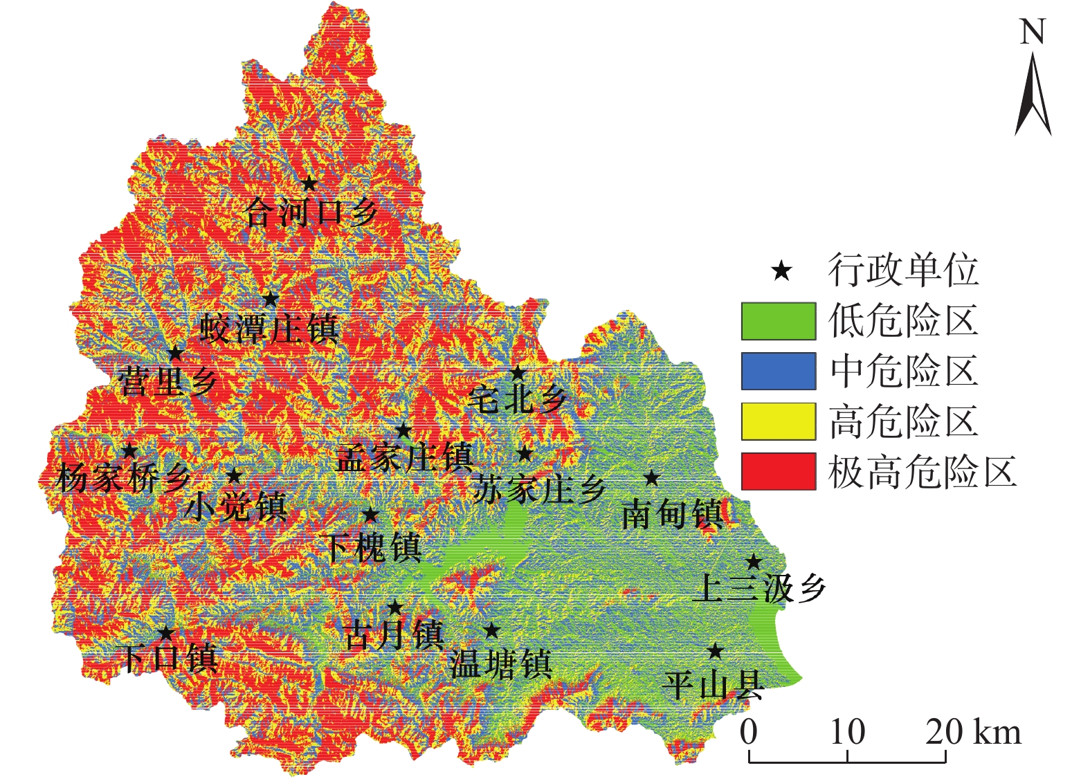
图 6 基于AHP平山县地质灾害危险性分区
Figure 6. Geological hazard zoning in Pingshan County based on AHP
![]()
图 7 基于突变理论平山县地质灾害危险性分区
Figure 7. Geological hazard zoning in Pingshan County based on catastrophe theory
![]()
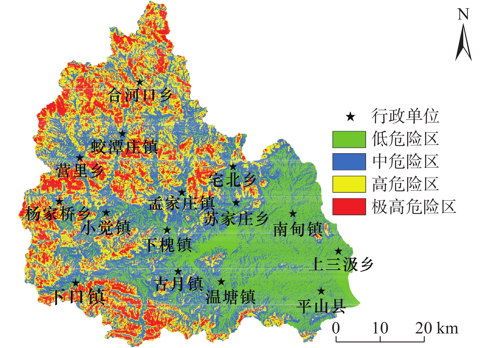
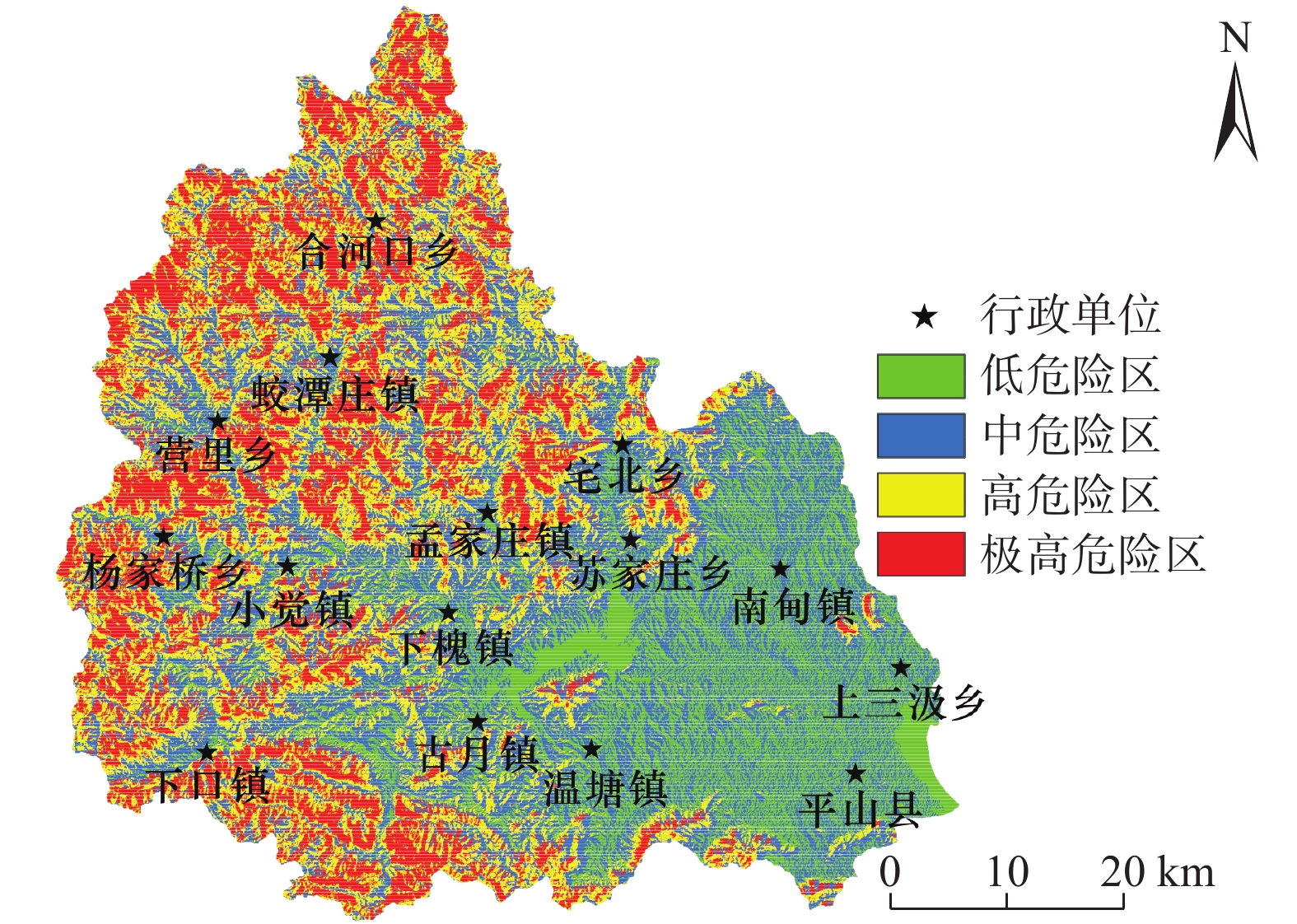
图 8 基于AHP-突变组合模型平山县地质灾害危险性分区
Figure 8. Geological hazard zoning in Pingshan County based on AHP - catastrophe combination model
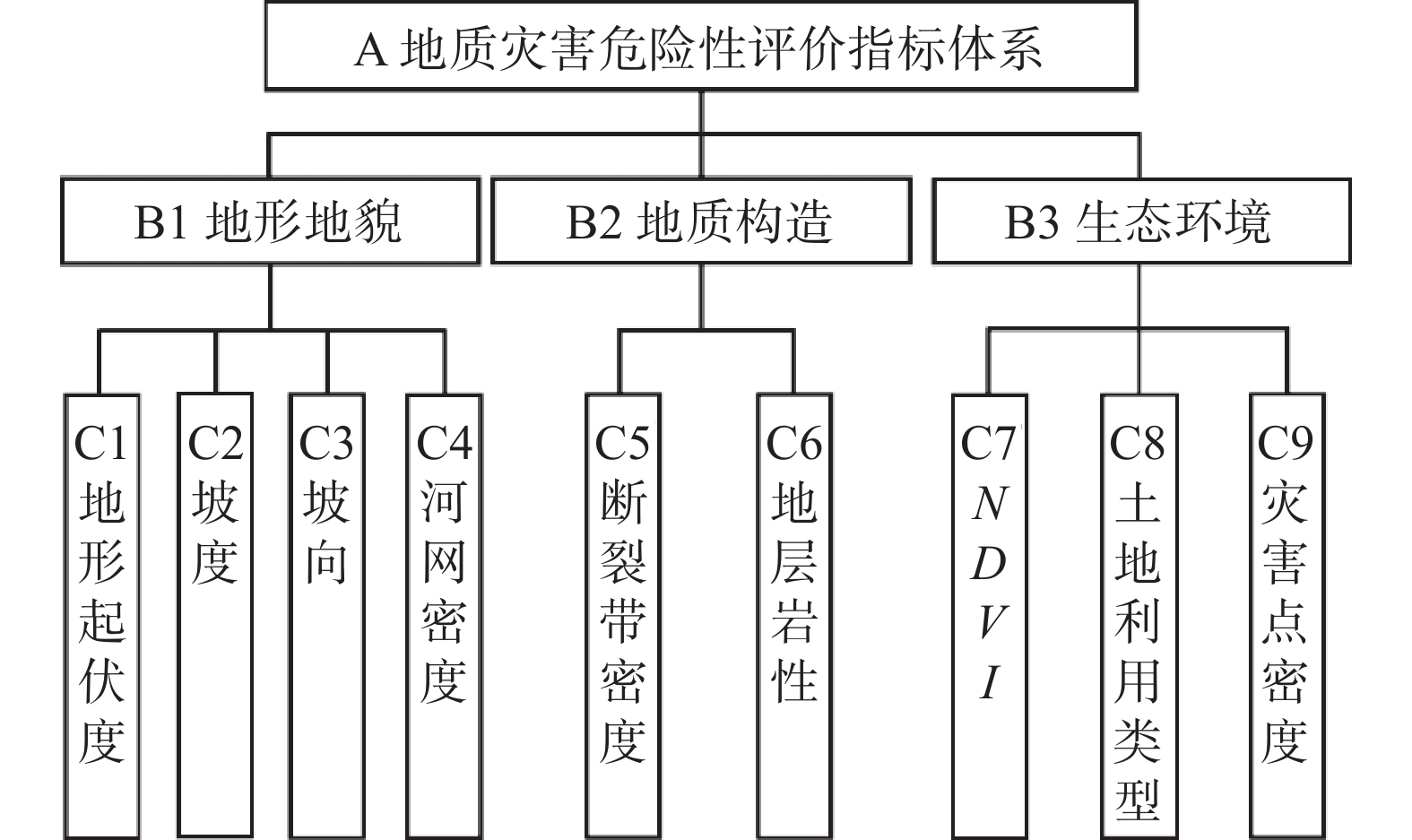
表 1 各评价方法求得权重对比
Table 1 Weight comparison of each evaluation method
目标层 准则层 评价因子层 AHP权重w1 突变理论权重w2 AHP-突变组合模型权重w3 A平山县地质
灾害危害性评价B1 地形地貌 C1 地形起伏度 0.1761 0.0795 0.1359 C2 坡度 0.3731 0.0717 0.1880 C3 坡向 0.0815 0.0795 0.0925 C4 河网密度 0.0380 0.0818 0.0641 B2 地质构造 C5 断裂带密度 0.0405 0.1065 0.0755 C6 地层岩性 0.2026 0.2486 0.2579 B3 生态环境 C7 NDVI 0.0249 0.1182 0.0624 C8 土地利用类型 0.0567 0.1220 0.0956 C9 灾害点密度 0.0065 0.0921 0.0281  下载: 导出CSV
表 2 状态变量的突变模型
Table 2 Catastrophe model of state variable
突变模型 控制变量维数 势函数 归一化公式 折叠突变 1 尖点突变 2 燕尾突变 3 蝴蝶突变 4 表 3 危险性分区统计与对比
Table 3 Risk zoning statistics and comparison
评价方法 危险性等级 面积占比/% AHP 低 25.14 中 33.37 高 27.16 极高 14.33 突变理论 低 13.96 中 26.36 高 28.16 极高 31.51 AHP-突变理论组合模型 低 18.39 中 32.61 高 27.49 极高 21.51
下载: 导出CSV
-
[1] 高泽民,丁明涛,杨国辉,等. 川藏铁路孜热—波密段泥石流灾害危险性评价[J]. 工程地质学报,2021,29(2):478 − 485. [GAO Zemin,DING Mingtao,YANG Guohui,et al. Hazard assessment of debris flow along zire-Bomi section of Sichuan-Tibet railway[J]. Journal of Engineering Geology,2021,29(2):478 − 485. (in Chinese with English abstract) DOI: 10.13544/j.cnki.jeg.2021-0160 GAO Zemin, DING Mingtao, YANG Guohui, et al. Hazard assessment of debris flow along zire-Bomi section of Sichuan-Tibet railway[J]. Journal of Engineering Geology, 2021, 29(2): 478-485. (in Chinese with English abstract) DOI: 10.13544/j.cnki.jeg.2021-0160
[2] 洪增林,李永红,张玲玉,等. 一种基于主成分分析法的区域性地质灾害危险性评估方法[J]. 灾害学,2020,35(1):118 − 124. [HONG Zenglin,LI Yonghong,ZHANG Lingyu,et al. A method of regional geological hazard assessment based on principle component analysis[J]. Journal of Catastrophology,2020,35(1):118 − 124. (in Chinese with English abstract) DOI: 10.3969/j.issn.1000-811X.2020.01.022 HONG Zenglin, LI Yonghong, ZHANG Lingyu, et al. A method of regional geological hazard assessment based on principle component analysis[J]. Journal of Catastrophology, 2020, 35(1): 118-124. (in Chinese with English abstract) DOI: 10.3969/j.issn.1000-811X.2020.01.022
[3] MEJIA-NAVARRO M,WOHL E E. Geological hazard and risk evaluation using GIS:methodology and model applied to Medellin,Colombia[J]. Environmental & Engineering Geoscience,1994(4):459 − 481.
[4] 魏会龙, 施秋华, 周金文, 等. 基于层次分析法的深圳市地面坍塌危险性评价[J]. 中国矿业, 2021, 30(增刊2): 110 − 116 WEI Huilong, SHI Qiuhua, ZHOU Jinwen, et al. Risk assessment of ground collapse in Shenzhen based on analytic hierarchy process[J]. China Mining Magazine, 2021, 30(Sup 2): 110 − 116. (in Chinese with English abstract)
[5] 王磊,常鸣,邢月龙. 基于信息量法模型与GIS的滑坡地质灾害风险性评价[J]. 地质灾害与环境保护,2021,32(2):14 − 20. [WANG Lei,CHANG Ming,XING Yuelong. Risk assessment of landslide geological hazards based on information method model and GIS[J]. Journal of Geological Hazards and Environment Preservation,2021,32(2):14 − 20. (in Chinese with English abstract) DOI: 10.3969/j.issn.1006-4362.2021.02.003 WANG Lei, CHANG Ming, XING Yuelong. Risk assessment of landslide geological hazards based on information method model and GIS[J]. Journal of Geological Hazards and Environment Preservation, 2021, 32(2): 14-20. (in Chinese with English abstract) DOI: 10.3969/j.issn.1006-4362.2021.02.003
[6] YU Kaining, FAN Cunliang, LI Jian, et al. Formation Characteristic and Comprehensive Classification of Debris Flow in Typical Mountain Area of the North of China[C]. The XVIII Kerulien International Conference on Geology. Geological Engineering and Mining Exploration in Central Asia. Australia: Aussino Academic Publishing House, 2013: 819-826.
[7] 张晓敏,李辉,刘海南,等. 基于灰色系统理论的陕西省地质灾害趋势预测[J]. 中国地质灾害与防治学报,2018,29(5):7 − 12. [ZHANG Xiaomin,LI Hui,LIU Hainan,et al. Trend prediction of geological hazards in Shaanxi Province based on Grey System Theory[J]. The Chinese Journal of Geological Hazard and Control,2018,29(5):7 − 12. (in Chinese with English abstract) DOI: 10.16031/j.cnki.issn.1003-8035.2018.05.02 ZHANG Xiaomin, LI Hui, LIU Hainan, et al. Trend prediction of geological hazards in Shaanxi Province based on Grey System Theory[J]. The Chinese Journal of Geological Hazard and Control, 2018, 29(5): 7-12. (in Chinese with English abstract) DOI: 10.16031/j.cnki.issn.1003-8035.2018.05.02
[8] 郭学飞,王志一,焦润成,等. 基于层次分析法的北京市地质环境质量综合评价[J]. 中国地质灾害与防治学报,2021,32(1):70 − 76. [GUO Xuefei,WANG Zhiyi,JIAO Runcheng,et al. Comprehensive evaluation method of geological environment quality in Beijing based on AHP[J]. The Chinese Journal of Geological Hazard and Control,2021,32(1):70 − 76. (in Chinese with English abstract) DOI: 10.16031/j.cnki.issn.1003-8035.2021.01.10 GUO Xuefei, WANG Zhiyi, JIAO Runcheng, et al. Comprehensive evaluation method of geological environment quality in Beijing based on AHP[J]. The Chinese Journal of Geological Hazard and Control, 2021, 32(1): 70-76. (in Chinese with English abstract) DOI: 10.16031/j.cnki.issn.1003-8035.2021.01.10
[9] 李小龙,宋国虎,向灵芝,等. 基于不同评价单元和灾害熵的泥石流危险性分析—以白龙江流域武都段为例[J]. 中国地质灾害与防治学报,2021,32(6):107 − 115. [LI Xiaolong,SONG Guohu,XIANG Lingzhi,et al. Hazard analysis of debris flows based on different evaluation units and disaster entropy:A case study in Wudu section of the Bailong River Basin[J]. The Chinese Journal of Geological Hazard and Control,2021,32(6):107 − 115. (in Chinese with English abstract) DOI: 10.16031/j.cnki.issn.1003-8035.2021.06-13 LI Xiaolong, SONG Guohu, XIANG Lingzhi, et al. Hazard analysis of debris flows based on different evaluation units and disaster entropy: a case study in Wudu section of the Bailong River Basin[J]. The Chinese Journal of Geological Hazard and Control, 2021, 32(6): 107-115. (in Chinese with English abstract) DOI: 10.16031/j.cnki.issn.1003-8035.2021.06-13
[10] 何珊,李志军,董富权,等. 基于层次分析法的多元信息成矿预测研究—以西藏洛扎地区为例[J]. 地质与勘探,2018,54(1):148 − 157. [HE Shan,LI Zhijun,DONG Fuquan,et al. Multiple information metallogenic prediction based on the analytic hierarchy process:A case study of the lhozhag area in Tibet[J]. Geology and Exploration,2018,54(1):148 − 157. (in Chinese with English abstract) DOI: 10.13712/j.cnki.dzykt.2018.01.016 HE Shan, LI Zhijun, DONG Fuquan, et al. Multiple information metallogenic prediction based on the analytic hierarchy process: a case study of the lhozhag area in Tibet[J]. Geology and Exploration, 2018, 54(1): 148-157. (in Chinese with English abstract) DOI: 10.13712/j.cnki.dzykt.2018.01.016
[11] KAYASTHA P,DHITAL M R,DE SMEDT F. Application of the analytical hierarchy process (AHP) for landslide susceptibility mapping:a case study from the Tinau watershed,west Nepal[J]. Computers & Geosciences,2013,52:398 − 408.
[12] 侯圣山,曹鹏,陈亮,等. 基于数值模拟的耳阳河流域泥石流灾害危险性评价[J]. 水文地质工程地质,2021,48(2):143 − 151. [HOU Shengshan,CAO Peng,CHEN Liang,et al. Debris flow hazard assessment of the Eryang River watershed based on numerical simulation[J]. Hydrogeology & Engineering Geology,2021,48(2):143 − 151. (in Chinese with English abstract) DOI: 10.16030/j.cnki.issn.1000-3665.202003057 HOU Shengshan, CAO Peng, CHEN Liang, et al. Debris flow hazard assessment of the Eryang River watershed based on numerical simulation[J]. Hydrogeology & Engineering Geology, 2021, 48(2): 143-151. (in Chinese with English abstract) DOI: 10.16030/j.cnki.issn.1000-3665.202003057
[13] WICAKSONO Y S,SIHOMBING F H,INDRA T L. Landslide susceptibility map of Bogor Area using analytical hierarchy process[J]. IOP Conference Series:Earth and Environmental Science,2020,538(1):012050. DOI: 10.1088/1755-1315/538/1/012050
[14] 陈绪新,秦哲,付厚利,等. 基于尖点突变模型饱水边坡稳定性分析[J]. 地质与勘探,2018,54(2):376 − 380. [CHEN Xuxin,QIN Zhe,FU Houli,et al. Analysis on stability of water-saturation slopes based on the cusp catastrophic model[J]. Geology and Exploration,2018,54(2):376 − 380. (in Chinese with English abstract) DOI: 10.13712/j.cnki.dzykt.2018.02.016 CHEN Xuxin, QIN Zhe, FU Houli, et al. Analysis on stability of water-saturation slopes based on the cusp catastrophic model[J]. Geology and Exploration, 2018, 54(2): 376-380. (in Chinese with English abstract) DOI: 10.13712/j.cnki.dzykt.2018.02.016
[15] 冯平,李绍飞,李建柱. 基于突变理论的地下水环境风险评价[J]. 自然灾害学报,2008,17(2):13 − 18. [FENG Ping,LI Shaofei,LI Jianzhu. Catastrophe theory-based risk evaluation of groundwater environment[J]. Journal of Natural Disasters,2008,17(2):13 − 18. (in Chinese with English abstract) DOI: 10.3969/j.issn.1004-4574.2008.02.003 FENG Ping, LI Shaofei, LI Jianzhu. Catastrophe theory-based risk evaluation of groundwater environment[J]. Journal of Natural Disasters, 2008, 17(2): 13-18. (in Chinese with English abstract) DOI: 10.3969/j.issn.1004-4574.2008.02.003
[16] 李绍飞,孙书洪,王向余. 突变理论在海河流域地下水环境风险评价中的应用[J]. 水利学报,2007,38(11):1312 − 1317. [LI Shaofei,SUN Shuhong,WANG Xiangyu. Application of catastrophe theory to risk assessment of groundwater environment for river basin[J]. Journal of Hydraulic Engineering,2007,38(11):1312 − 1317. (in Chinese with English abstract) DOI: 10.3321/j.issn:0559-9350.2007.11.007 LI Shaofei, SUN Shuhong, WANG Xiangyu. Application of catastrophe theory to risk assessment of groundwater environment for river basin[J]. Journal of Hydraulic Engineering, 2007, 38(11): 1312-1317. (in Chinese with English abstract) DOI: 10.3321/j.issn:0559-9350.2007.11.007
[17] 袁颖,李佳玉. 岩质边坡稳定性评价的尖点突变理论模型[J]. 地质与勘探,2021,57(1):183 − 189. [YUAN Ying,LI Jiayu. A cusp catastrophe theory model for evaluation of rock slope stability[J]. Geology and Exploration,2021,57(1):183 − 189. (in Chinese with English abstract) YUAN Ying, LI Jiayu. A cusp catastrophe theory model for evaluation of rock slope stability[J]. Geology and Exploration, 2021, 57(1): 183-189. (in Chinese with English abstract)
[18] 尚志海,蔡文慧,欧先交,等. 基于突变理论的梅州市地质灾害灾度评估[J]. 安全与环境工程,2014,21(3):55 − 59. [SHANG Zhihai,CAI Wenhui,OU Xianjiao,et al. Geological hazard degree assessment of Meizhou City based on catastrophe theory[J]. Safety and Environmental Engineering,2014,21(3):55 − 59. (in Chinese with English abstract) DOI: 10.3969/j.issn.1671-1556.2014.03.011 SHANG Zhihai, CAI Wenhui, OU Xianjiao, et al. Geological hazard degree assessment of Meizhou City based on catastrophe theory[J]. Safety and Environmental Engineering, 2014, 21(3): 55-59. (in Chinese with English abstract) DOI: 10.3969/j.issn.1671-1556.2014.03.011
[19] 温晓艺,郑秀清,陈军锋,等. 基于突变理论的地质灾害风险性评价[J]. 山东农业大学学报(自然科学版),2019,50(4):575 − 581. [WEN Xiaoyi,ZHENG Xiuqing,CHEN Junfeng,et al. Risk assessment of geological disaster based on catastrophe theory[J]. Journal of Shandong Agricultural University (Natural Science Edition),2019,50(4):575 − 581. (in Chinese with English abstract) DOI: 10.3969/j.issn.1000-2324.2019.04.008 WEN Xiaoyi, ZHENG Xiuqing, CHEN Junfeng, et al. Risk assessment of geological disaster based on catastrophe theory[J]. Journal of Shandong Agricultural University (Natural Science Edition), 2019, 50(4): 575-581. (in Chinese with English abstract) DOI: 10.3969/j.issn.1000-2324.2019.04.008
[20] 陈菊艳,朱斌,彭三曦,等. 基于AHP和GIS的矿区岩溶塌陷易发性评估—以贵州林歹岩溶矿区为例[J]. 自然灾害学报,2021,30(5):226 − 236. [CHEN Juyan,ZHU Bin,PENG Sanxi,et al. Assessment of susceptibility to Karst collapse in mining area based on AHP and GIS:A case study in Lindai Karst mining area in Guizhou[J]. Journal of Natural Disasters,2021,30(5):226 − 236. (in Chinese with English abstract) DOI: 10.13577/j.jnd.2021.0522 CHEN Juyan, ZHU Bin, PENG Sanxi, et al. Assessment of susceptibility to Karst collapse in mining area based on AHP and GIS: a case study in Lindai Karst mining area in Guizhou[J]. Journal of Natural Disasters, 2021, 30(5): 226-236. (in Chinese with English abstract) DOI: 10.13577/j.jnd.2021.0522
[21] 杜国梁,杨志华,袁颖,等. 基于逻辑回归-信息量的川藏交通廊道滑坡易发性评价[J]. 水文地质工程地质,2021,48(5):102 − 111. [DU Guoliang,YANG Zhihua,YUAN Ying,et al. Landslide susceptibility mapping in the Sichuan-Tibet traffic corridor using logistic regression-information value method[J]. Hydrogeology & Engineering Geology,2021,48(5):102 − 111. (in Chinese with English abstract) DU Guoliang, YANG Zhihua, YUAN Ying, et al. Landslide susceptibility mapping in the Sichuan-Tibet traffic corridor using logistic regression-information value method[J]. Hydrogeology & Engineering Geology, 2021, 48(5): 102-111. (in Chinese with English abstract)
[22] 李博. GRA—FAHP模型的煤层底板突水危险性评价[J]. 地质论评,2015,61(5):1128 − 1134. [LI Bo. Risk assessment model of coal floor water-irruption based on GRA-FAHP[J]. Geological Review,2015,61(5):1128 − 1134. (in Chinese with English abstract) DOI: 10.16509/j.georeview.2015.05.015 LI Bo. Risk assessment model of coal floor water-irruption based on GRA-FAHP[J]. Geological Review, 2015, 61(5): 1128-1134. (in Chinese with English abstract) DOI: 10.16509/j.georeview.2015.05.015
[23] 刘璐瑶,高惠瑛,李照. 基于CF与Logistic回归模型耦合的永嘉县滑坡易发性评价[J]. 中国海洋大学学报(自然科学版),2021,51(10):121 − 129. [LIU Luyao,GAO Huiying,LI Zhao. Landslide susceptibility assessment based on coupling of CF model and logistic regression model in Yongjia County[J]. Periodical of Ocean University of China,2021,51(10):121 − 129. (in Chinese with English abstract) LIU Luyao, GAO Huiying, LI Zhao. Landslide susceptibility assessment based on coupling of CF model and logistic regression model in Yongjia County[J]. Periodical of Ocean University of China, 2021, 51(10): 121-129. (in Chinese with English abstract)
[24] SHAHINUZZAMAN M,HAQUE M N,SHAHID S. Delineation of groundwater potential zones using a parsimonious concept based on catastrophe theory and analytical hierarchy process[J]. Hydrogeology Journal,2021,29(3):1091 − 1116. DOI: 10.1007/s10040-021-02322-2
[25] 宁娜,马金珠,张鹏,等. 基于GIS和信息量法的甘肃南部白龙江流域泥石流灾害危险性评价[J]. 资源科学,2013,35(4):892 − 899. [NING Na,MA Jinzhu,ZHANG Peng,et al. Debris flow hazard assessment for the Bailongjiang River,southern Gansu[J]. Resources Science,2013,35(4):892 − 899. (in Chinese with English abstract) NING Na, MA Jinzhu, ZHANG Peng, et al. Debris flow hazard assessment for the Bailongjiang River, southern Gansu[J]. Resources Science, 2013, 35(4): 892-899. (in Chinese with English abstract)
[26] 覃乙根,杨根兰,江兴元,等. 基于确定性系数模型与逻辑回归模型耦合的地质灾害易发性评价—以贵州省开阳县为例[J]. 科学技术与工程,2020,20(1):96 − 103. [QIN Yigen,YANG Genlan,JIANG Xingyuan,et al. Geohazard susceptibility assessment based on integrated certainty factor model and logistic regression model for Kaiyang,China[J]. Science Technology and Engineering,2020,20(1):96 − 103. (in Chinese with English abstract) DOI: 10.3969/j.issn.1671-1815.2020.01.015 QIN Yigen, YANG Genlan, JIANG Xingyuan, et al. Geohazard susceptibility assessment based on integrated certainty factor model and logistic regression model for Kaiyang, China[J]. Science Technology and Engineering, 2020, 20(1): 96-103. (in Chinese with English abstract) DOI: 10.3969/j.issn.1671-1815.2020.01.015
[27] 杨宁, 陶志斌, 高松, 等. 基于AHP的DRASTIC模型对莱州地区地下水脆弱性研究[J]. 地质学报, 2019, 93(增刊 1): 133 − 137 YANG Ning, TAO Zhibin, GAO Song, et al. Study of groundwater vulnerability in Laizhou using AHP-based DRASTIC model[J]. Acta Geologica Sinica, 2019, 93(Sup 1): 133 − 137. (in Chinese with English abstract)
[28] YING X,ZENG G M,CHEN G Q,et al. Combining AHP with GIS in synthetic evaluation of eco-environment quality—a case study of Hunan Province,China[J]. Ecological Modelling,2007,209(2/3/4):97 − 109.
[29] 夏兴生,朱秀芳,李月臣,等. 基于AHP-PCA熵组合权重模型的三峡库区(重庆段)农业生态环境脆弱性评价[J]. 南方农业学报,2016,47(4):548 − 556. [XIA Xingsheng,ZHU Xiufang,LI Yuechen,et al. Evaluation for vulnerability of agroecological environment in Three Gorges Reservoir area(Chongqing section)based on AHP-PCA entropy combination weight mode[J]. Journal of Southern Agriculture,2016,47(4):548 − 556. (in Chinese with English abstract) DOI: 10.3969/j:issn.2095-1191.2016.04.548 XIA Xingsheng, ZHU Xiufang, LI Yuechen, et al. Evaluation for vulnerability of agroecological environment in Three Gorges Reservoir area(Chongqing section)based on AHP-PCA entropy combination weight mode[J]. Journal of Southern Agriculture, 2016, 47(4): 548-556. (in Chinese with English abstract) DOI: 10.3969/j:issn.2095-1191.2016.04.548
[30] 杨康,薛喜成,段钊,等. 基于AHP-LR熵组合模型的子长市地质灾害危险性评价[J]. 科学技术与工程,2021,21(27):11551 − 11560. [YANG Kang,XUE Xicheng,DUAN Zhao,et al. Risk assessment of geological hazards in Zichang County based on AHP-LR entropy combined model[J]. Science Technology and Engineering,2021,21(27):11551 − 11560. (in Chinese with English abstract) DOI: 10.3969/j.issn.1671-1815.2021.27.013 YANG Kang, XUE Xicheng, DUAN Zhao, et al. Risk assessment of geological hazards in Zichang County based on AHP-LR entropy combined model[J]. Science Technology and Engineering, 2021, 21(27): 11551-11560. (in Chinese with English abstract) DOI: 10.3969/j.issn.1671-1815.2021.27.013
-
期刊类型引用(1)
1. 苏娜,徐林荣,李永威,李佳珅,汤玉兰. 汶川地震震后七盘沟泥石流动态物源危险性评价. 中国地质灾害与防治学报. 2025(01): 16-27 .  本站查看
本站查看
其他类型引用(0)


计量
- 文章访问数: 5157
- HTML全文浏览量: 3233
- PDF下载量: 519
- 被引次数: 1
 邮件订阅
邮件订阅 RSS
RSS