

Application of combined space, arial and ground based multiple technologies in deformation monitoring of mining areas
-
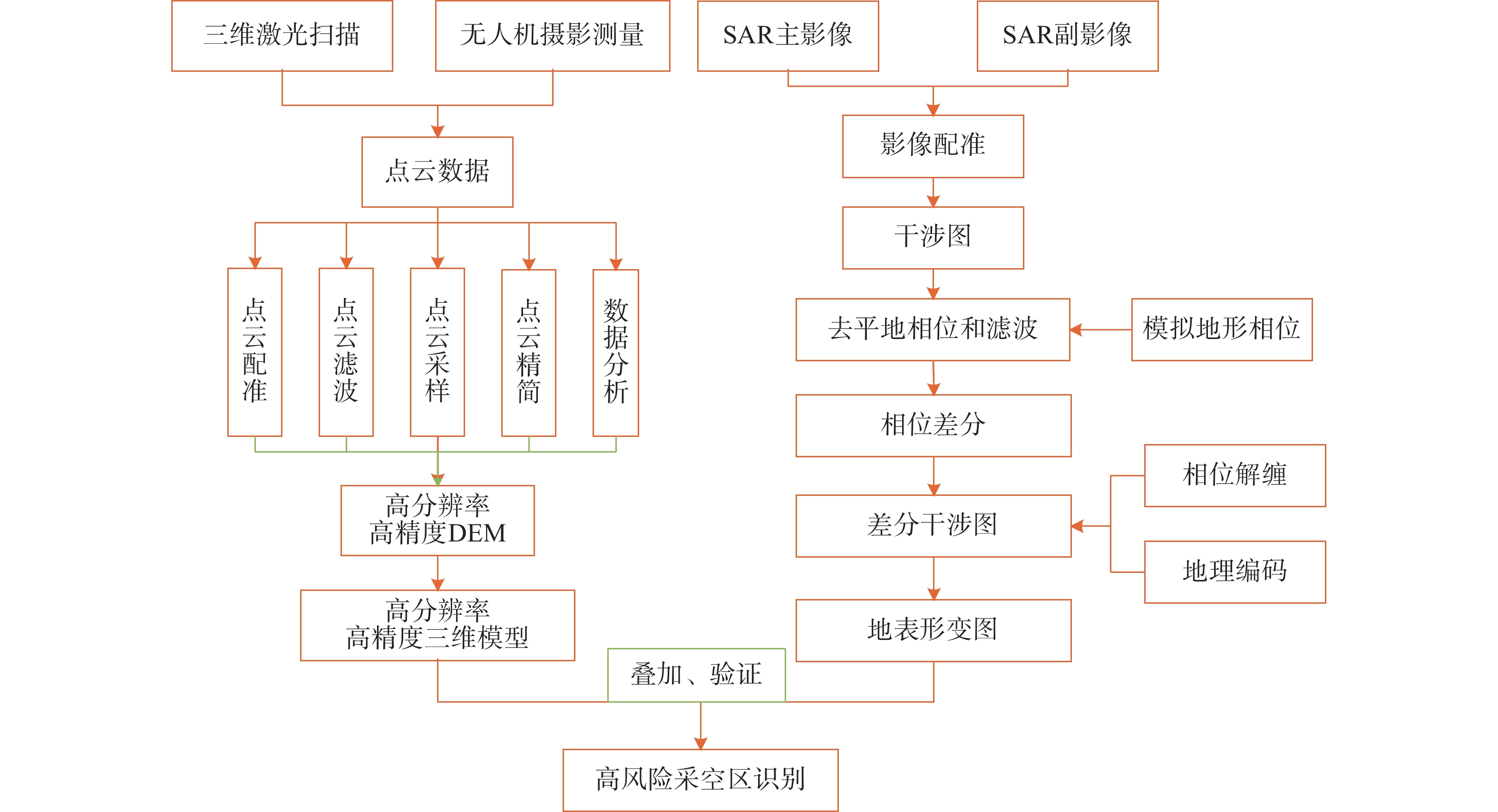
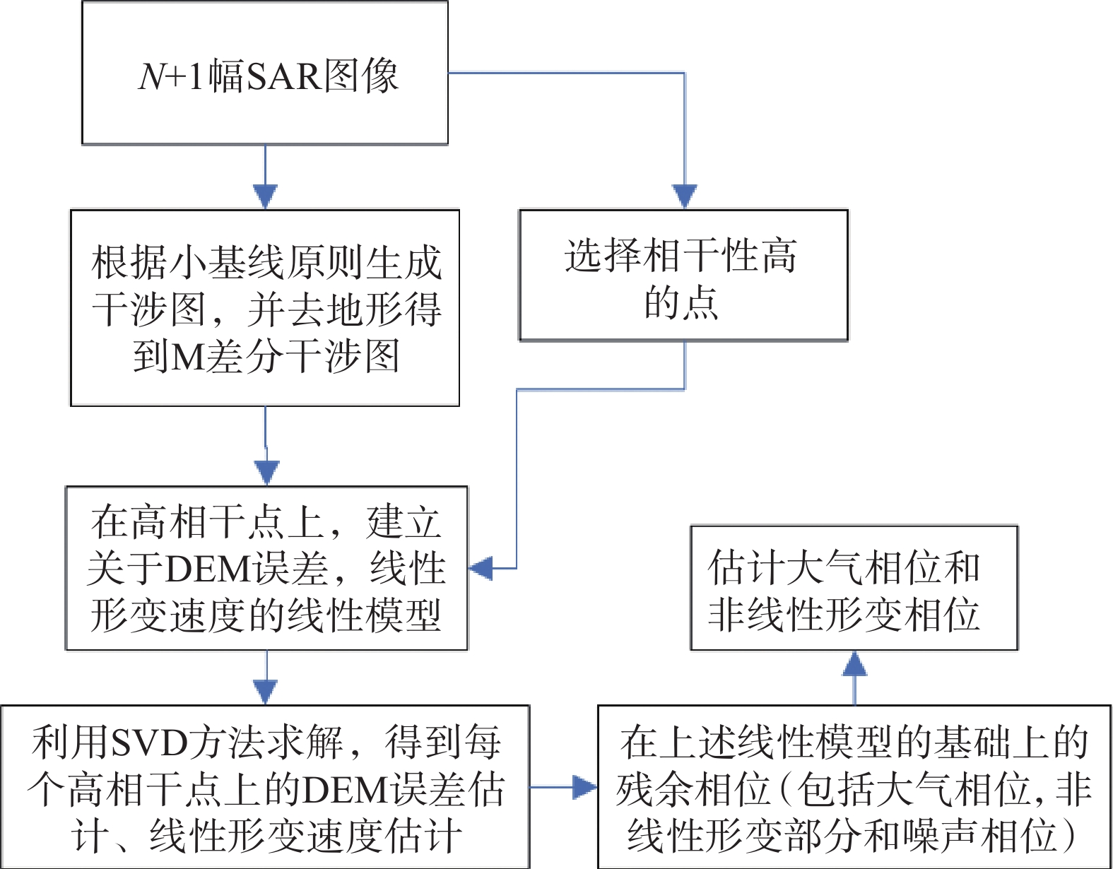
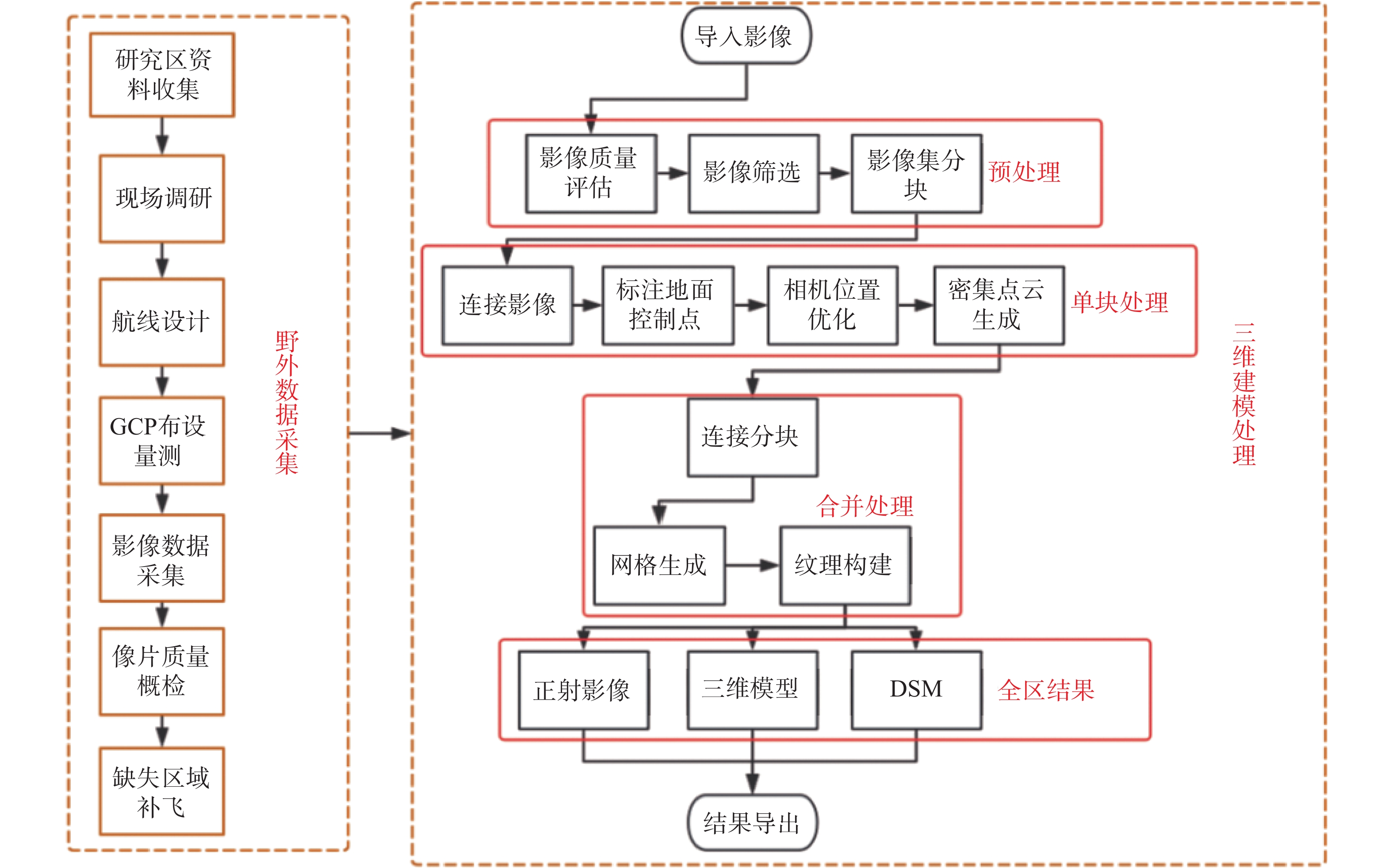
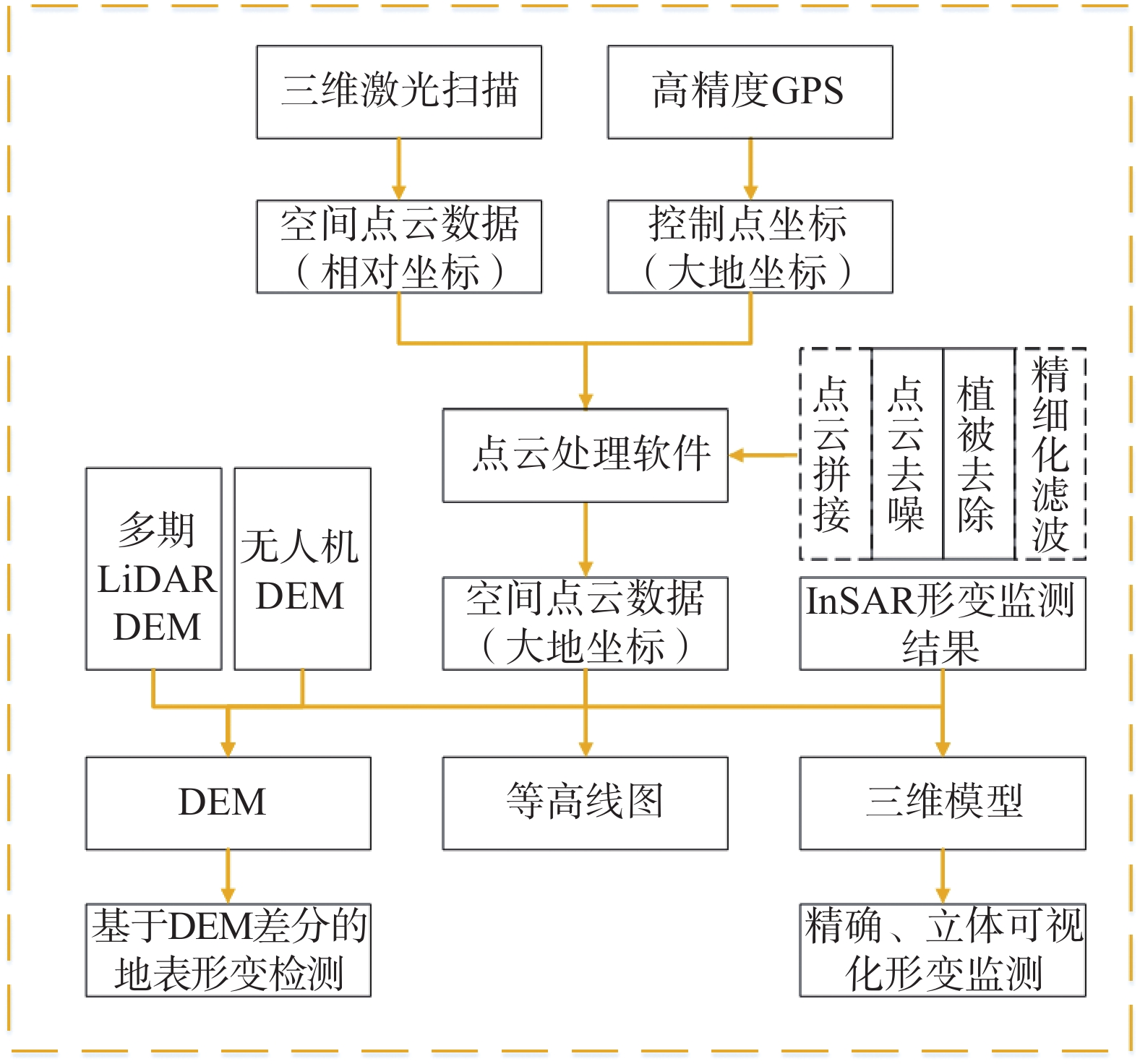
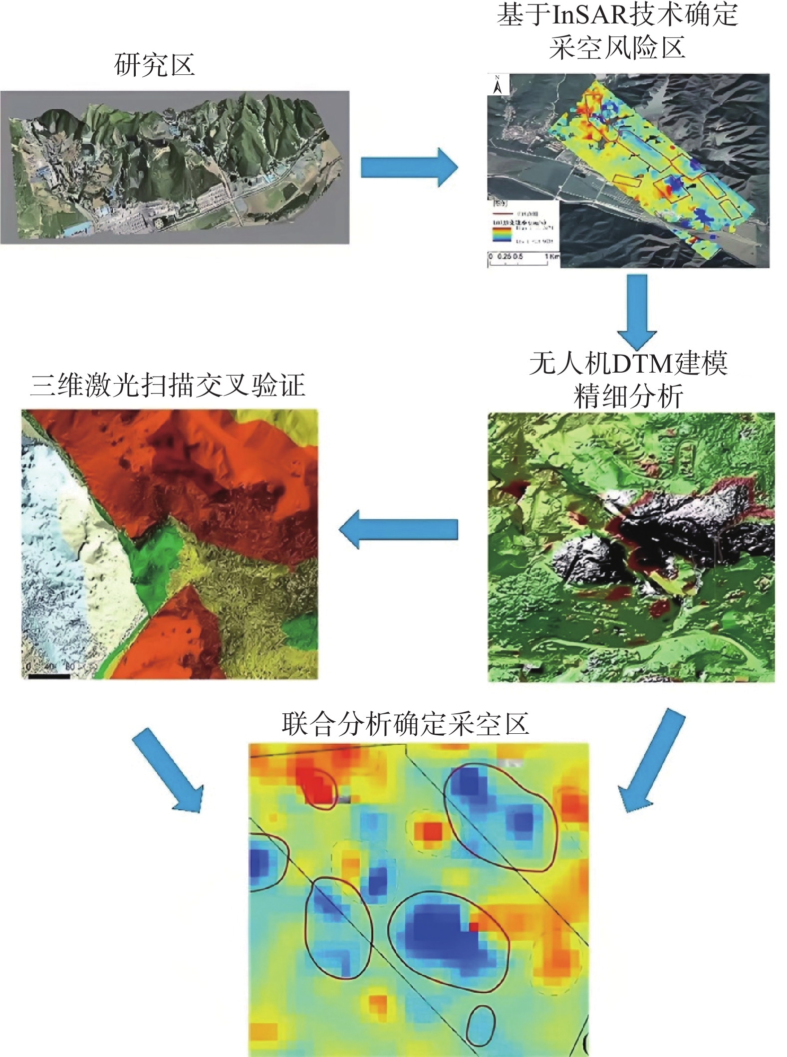
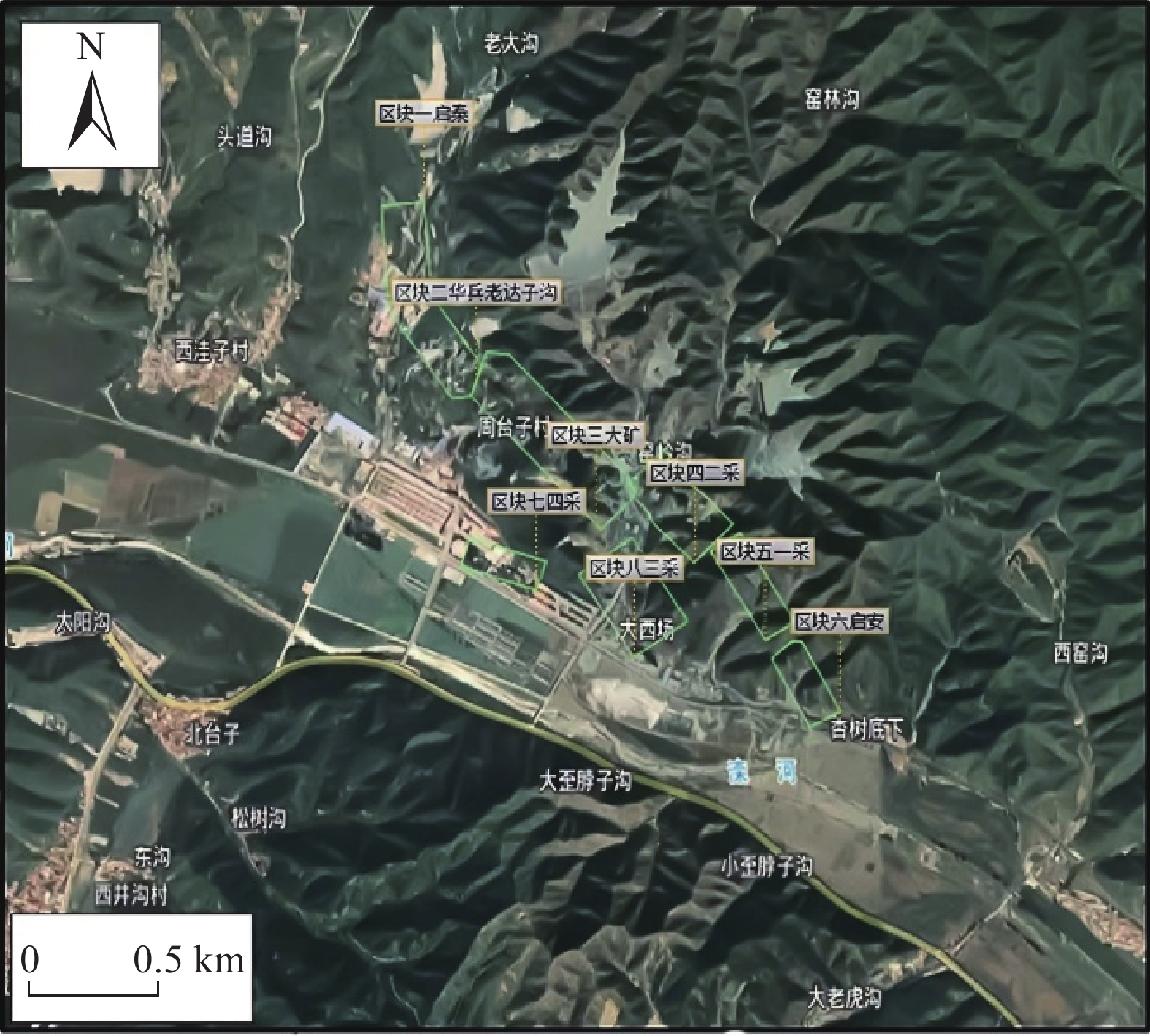
摘要: 河北滦平县张百湾镇周台子村由于多年矿山开采遗留下大量的采空区,部分采空区未做任何处理存在塌陷隐患,严重制约当地的经济发展和社会稳定。对该地区采空区形变调查和实地监测十分有必要。文中综合应用合成孔径雷达干涉测量技术、无人机摄影测量技术、三维激光扫描技术对采空区的空间分布进行划分确定和形变监测。首先应用小基线集技术对采空区进行地表形变解算。然后应用无人机数据构建研究区的三维模型,并通过多期无人机航飞数据,计算2次航飞间地表变化,佐证InSAR技术的结果。最后应用三维激光扫描技术,对部分重点区域进行三维激光扫描,建立采空区精细化模型。研究结果表明,三种技术的联合监测结果表现出高度的一致性,其中InSAR技术探测出研究区最大形变速率−25 mm/a,结合2期无人机正射模型DEM与三维激光扫描数据差分结果确定出采空区17处的高风险区域,部分区域对居民区和道路有影响。基于“空天地”一体化技术具有较高的可靠性,可应用于矿区采空区形变调查和地面沉降监测。
-
关键词:
- 采空区 /
- InSAR技术 /
- 无人机摄影测量 /
- SBAS-InSAR /
- 三维激光扫描
Abstract: There are a large number of iron mine gobs due to many years of mining in Zhoutaizi Village, Zhangbaiwan Town, Luanping County. And some gobs have potential safety hazards of collapse, which seriously restrict the local economic development and social stability. So it is necessary to strengthen deformation investigation and field monitoring of existing gobs in this area. In this paper, the spatial distribution of gobs in the study area is determined and deformation of gobs is monitored by using Interferometric Synthetic Aperture Radar (InSAR), UAV photogrammetry and 3D laser scanning technology. Firstly, Small Baseline Subset InSAR (SBAS-InSAR) technology is used to retrieve the surface deformation of gobs. Then, a three-dimensional model of the study area is constructed by using UAV data, and the ground surface changes between two flights are calculated by using multi-period UAV flight data to support the results of InSAR technology. Finally, 3D laser scanning technology is applied to some areas, and the fine model of gobs is established. The results show that the joint monitoring results of the three technologies show a high consistency, the maximum deformation rate (−25 mm/a) of the study area are detected by InSAR method. Combined with the difference results of the DEM and 3D laser scanning data of the two periods of UAV, 17 high-risk areas of gobs are identified. The high-risk areas are distributed in various mining areas, and some areas have an impact on residential areas and roads. The based on Space, Sky and Ground multi-technology indicating that this method has high reliability and can be well applied to deformation investigation of goaf in mining area and the surface deformation monitoring during inadequate mining.-
Keywords:
- gobs /
- InSAR technology /
- UAV photogrammetry /
- SBAS-InSAR /
- 3D laser scanning
-
《中国地质灾害与防治学报》(双月刊)是由中国地质调查局主管,中国地质环境监测院、中国地质灾害防治与生态修复协会主办,反映地质灾害学科并向国内外公开发行的学术性刊物。由于贯彻了“双百”方针,理论与实践密切结合,充分运用地质灾害防治技术,重视办刊质量,因而受到同行的好评。欢迎广大科技人员和读者积极投稿。
一. 征稿范围
主要刊登范围:重点刊登地质灾害发生发展机理、成灾模式与应急处置、地质灾害链及风险评价、调查/监测/预警与综合防治,空天地一体化早期识别和普适型监测仪器研发,重大工程沿线地质灾害研究与防治等方面的创新性研究成果。
本刊物主要面向国内工程地质学科发展、地质工程建设、技术方法创新、地质环境开发与保护等方面的院校教师、研究生及科技人员。期刊最初定位是服务于生产一线的野外工作者。是我国工程地质、环境地质、特别是地质灾害研究(地质灾害防治及地质环境保护)等领域的综合性学术理论与实践相结合的地质学类权威性刊物。
二. 征稿内容
理论研究与调查评价栏目:重点针对单体单灾分析研究与调查评价;
技术方法与防治工程栏目:技术方法,是指勘察、监测、防治等具体的技术方法,不是评价方法和研究方法,这是业界约定俗成的共识;
综合研究与区划栏目:对多灾种综合研究、区域性灾害研究和易发性、危险性和风险评价与区划。
三. 稿件要求
(一) 稿件结构要求
0 引言(Introduction)
以简短的文字介绍写作背景和目的,以及相关领域内前人所作的工作和研究的概况(即前人研究进展的综述),说明本研究与前人研究工作的关系,目前研究的热点和存在的问题;以便读者了解该文的概貌,起导读的作用。基本内容应包括:
(1)简要叙述研究此项工作的起因和目的(研究背景);(2)国内外对此项工作的研究现状和研究动态(并指出存在的问题);(3)强调此项研究工作拟解决现有研究中存在问题中的哪个问题,以及研究解决这些问题的重要性和意义;(4)适当说明研究假设。
1 材料与方法(Methods)
这是论文的重要部分。重点阐述两方面的内容,一是用什么做研究(即研究所用的材料),二是怎么做研究(从事研究所用的方法)。如果采用的方法是按照前人的,或者即使有所改进,也必须标注参考文献。
不同的课题有不同的研究方法,以试验研究方法为例,其内容应包括:(1)研究的对象及其取样;(2)仪器设备的应用;(3)相关因素和无关因素的控制;(4)操作程序与方法;(5)操作性概念的界定;(6)研究结果的统计方法。针对基于地质调查的研究论文,可将第1节设置为“研究区地质背景”,其内容包括:(1)野外调查工作和试验室测试所用的技术方法或技术手段(野外工作技术路线),开展完成的主要工作(及其量);(2)所得到第一手资料情况以及开展综合研究所应用的基础数据(包括利用前人已有数据)情况;(3)室内综合研究所用的方法(技术路线)。
2 结果(Results)
结果是论文的核心(主体部分),主要论述通过试验研究得到了什么数据、规律和发现等(可包括试验和研究的结果、数据,被确定的关系,观察或得到的效果、性能等)。
结果内容的表达:(1)数据,不用原始数据,要经统计学处理;(2)图表,用于显示规律性和对比性;(3)照片,能形象客观地表达研究结果;(4)文字,对数据、图表、照片加以说明。
结果的写作应注意:(1)按试验所得到的事实材料进行安排,可分段、分节,可加小标题;(2)解释客观结果,不要外加作者的评价、分析和推理;(3)结果要真实性,不可将不符合主观设想的数据或其它结果随意删除;(4)因图表和照片所占篇幅较大,能用文字说明的问题,尽可能少用或不用图表或照片。
3 讨论(Discussion)
讨论是论文的重要主体部分,是作者对研究得到的资料进行归纳、概括和探讨,提出自己的见解,评价其意义。
讨论的内容包括:(1)对试验观察过程中各种数据或现象的理论分析和解释;(2)评估研究方法的科学性,评估自己结果的正确性和可靠性,与他人结果比较异同,并解释其原因;(3)试验结果的理论意义及对实践的指导作用和应用价值;(4)作用机制或变化规律的探讨;(5)本研究还存在的局限性以及进一步研究的建议。
4 结论(及建议)(Conclusion)
这是论文的精髓部分。要回答研究出了什么,主要内容应包括:
(1)由研究结果所揭示的原理及其普遍性(即本研究结果说明了什么问题,得出了什么规律性的东西,解决了什么理论或实际问题);
*(2)研究中有无例外或本论文尚难解决的问题(还有哪些问题没有解决),与以前以发表论文的异同,在理论与实践上意义;
*(3)对进一步研究的建议。
需要特别注意的是,结论不是摘要的简单重复。结语部分文字要简洁,逐条写出,3~4 条为宜。
(二) 稿件内容要求
(1)论文标题需明确、精练,体现创新点。具体要求:
● 阐述具体,用语简洁。题目不足以概括论文内容时,可加副标题;
● 文题相称、确切鲜明,标题体现内容,内容说明标题;
● 重点突出、主题明确,突出论文创新点,高度概括,一目了然。
(2)基金资助的研究项目,需注明资助项目来源及编号。
(3)作者一般只列出主要参加者。第一作者和通讯作者附简介:姓名(出生年—),性别,学历,职称,主要从事工作或研究方向,E-mail。
(4)摘要应具有独立性和自明性,即通过阅读摘要就能获得必要的信息。摘要的内容包括研究目的、方法、结果和结论,也可适当增加背景和意义,500字左右。英文摘要与中文摘要内容基本一致,可以适当扩充。关键词5~8个,要严格筛选,选用实词,充分、准确、全面地反映文章的中心内容。具体要求:
● 目的(objective):阐述论文要解决的问题及其起源、由来(适当突出问题的重要性和目前存在的不足,指出你的论文工作要解决存在的不足中的什么问题);
● 方法(methods):说明论文采用的主要手段(方法),必要时介绍使用手段的方式;
● 结果(results):说明研究内容中得出的主要结果,得到了什么数据、规律和发现等;
● 结论(conclusions):说明研究结果有什么含义、影响和意义(理论意义或实用价值、推广前景等)。
(5)全文一般不超过 10 个版面(包括图、表)。
(6)论文需符合科技论文体裁,论点明确,论据充分,论述严谨,结论可信,语句通达,逻辑严密。
(7)正文采用 3 级标题,即:一级标题如“2 模型建立及计算方法”;二级标题如“2.1 模型建立”;三级标题如 “2.1.1 模型建立基本原则”或“(1)模型建立基本原则”。
(8)提供必要的图表。表格一般采用三线表,使用国家法定计量单位,采用国际标准符号。图件采用通用制图软件制作,单栏图宽不超过 8 cm,通栏图宽不超过 16 cm,图面内容主题突出、结构合理、图面清晰,图中内容要与图注和正文叙述相符。中、英文图表名齐全,图名置于图件之下,表名置于表格之上。
(9)论文要突出反映基础和试验数据,对前人研究成果及存在问题或不足要进行充分的总结、分析。
(10)参考文献遵循“最新、关键、必要和亲自阅读过”的原则,采用顺序编码制,在正文中用“[ 1 ]”或“[1-2]”在引用处标注。所有文献需用信息资源原语种著录,中文文献需列出英译文。
列出论文参考文献的目的是让读者了解论文研究命题的来龙去脉,便于查找,同时也是尊重前人劳动,对自己的工作有准确的定位。一切粗心大意、不查文献,故意不引、自鸣创新,贬低别人、抬高自己,避重就轻、故作姿态的做法都是错误的。
四. 稿件录用
(1)本刊只接收网络投稿,投稿网址为http://www.zgdzzhyfzxb.com。
(2)自收稿日起 3 个月内,编辑部通知作者稿件处理结果。退稿不附详细意见。
(3)作者收到修改通知后 2 个月内返回修改稿。逾期(特殊原因且已向编辑部说明者除外)视为自动撤稿。
(4)期刊不收取审稿费,按规定收取版面费和支付稿费(含印刷版、光盘版和网络版),每篇论文赠送当期刊物 2 本。
(5)为了保证期刊正常出版,《中国地质灾害与防治学报》收取版面费,需要由作者或其所在机构、基金资助项目等支付。如果作者确无课题经费支付版面费可申请减免。申请方式:作者提交经单位科研管理部门盖章的书面申请,并提供单位科研管理部门的联系电话,编辑部经确认后即可减免。
论文出版版面费收费标准为:每面收取300元;加急论文出版版面费收费标准为:每面收取600元。
五. 声明
作者应对所投稿件拥有无可争议的著作权,且文责自负。作者应保证稿件未一稿多投,且保证我刊的首发权。稿件一旦被本刊录用,作者即将论文整体及附属于论文的图表等可许可使用的著作权(包括但不限于复制权、发行权、信息网络传播权、翻译权、汇编权),转交给本刊。许可期限为论文著作权的法定保护期,许可地域范围为全世界。作者依著作权法行使上述权利或向第三方转让上述权利时,不得损害本刊利益,如汇编入其他论文集时,必须注明曾在本刊刊出,并注明刊载年、卷、期。
(2022 年 2 月修订)
-
![]()
图 2 研究区全区正射影像图及细节展示
Figure 2. Orthophoto map and detail display of the whole study area
![]()
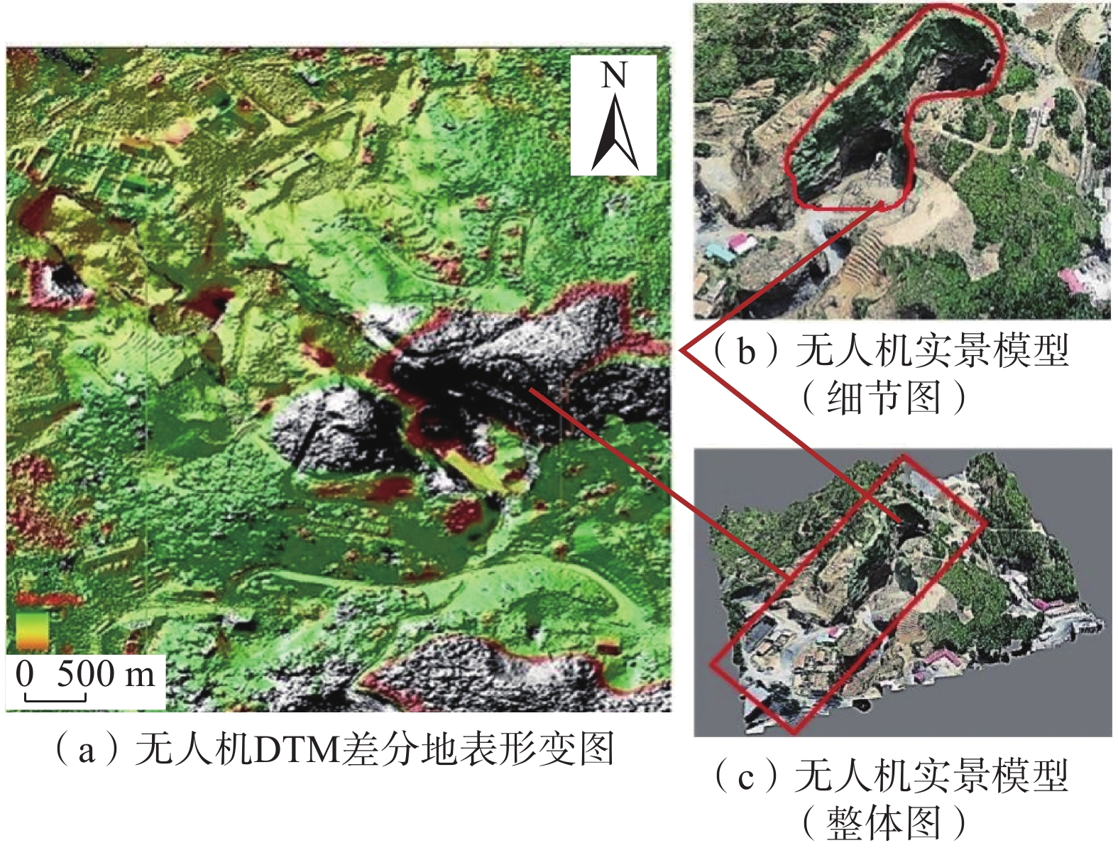
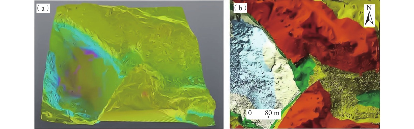
图 9 无人机DTM差分地表形变图及实景模型(区块三)
Figure 9. UAV DTM differential surface deformation diagram and real scene model in block 3
![]()
图 12 InSAR、无人机多角度对比综合分析图
Figure 12. Multi angle comparison and comprehensive analysis of InSAR and UAV
![]()
图 13 区块1多结果叠合高风险采空区区域图
Figure 13. Regional map of high-risk goaf with multi result superposition in block 1
![]()
图 14 区块2多结果叠合高风险采空区区域图
Figure 14. Regional map of high-risk goaf with multi result superposition in block 2
![]()
图 15 区块3多结果叠合高风险采空区区域图
Figure 15. Regional map of high-risk goaf with multi result superposition in block 3
![]()
图 16 区块8多结果叠合高风险采空区区域图
Figure 16. Regional map of high-risk goaf with multi result superposition in block 8
表 1 研究区Sentinel-1数据
Table 1 Sentinel-1 data in the research area
Sentinel-1A升轨影像数据集 编号 成像日期 垂直基线/m 时间基线/d 多普勒频差/Hz 高程模糊度/m 0 2018-11-06 0.00 0 0.00 0.00 1 2018-12-12 57.96 36 −4.61 262.75 2 2019-01-05 −8.46 60 7.27 1 799.97 3 2019-02-10 95.92 96 3.33 158.75 4 2019-03-06 113.21 120 5.57 134.52 5 2019-04-11 125.46 156 −3.34 121.38 6 2019-11-01 128.02 360 −5.10 118.96 7 2019-12-07 74.24 396 −3.10 205.13 8 2020-01-12 61.75 432 0.86 246.60 9 2020-02-05 62.86 456 0.54 242.27 10 2020-03-12 141.33 492 2.36 107.75 11 2020-04-05 97.92 516 3.22 155.52 Sentinel-1A降轨影像数据集 编号 成像日期 垂直基线/m 时间基线/d 多普勒频差/Hz 高程模糊度/m 0 2018-11-05 0.00 0 0.00 0.00 1 2018-12-11 32.79 36 1.49 518.88 2 2019-01-04 −30.31 60 3.69 561.38 3 2019-02-09 17.13 96 1.14 993.06 4 2019-03-05 −39.30 120 −7.84 432.96 5 2019-04-10 61.11 156 −14.1 278.41 6 2019-11-12 −31.83 372 −2.95 534.49 7 2019-12-06 47.26 396 4.70 360.03 8 2020-01-11 −58.43 432 −3.82 291.19 9 2020-02-04 −9.43 456 1.16 1 805.11 10 2020-03-11 −5.50 492 −7.30 3 095.02  下载: 导出CSV
-
[1] 孙健. 基于二等水准测量的矿区沉降监测研究分析[J]. 北京测绘,2019,33(8):979 − 981. [SUN Jian. Research and analysis of mining area settlement monitoring based on second-class measurement[J]. Beijing Surveying and Mapping,2019,33(8):979 − 981. (in Chinese with English abstract) SUN Jian. Research and analysis of mining area settlement monitoring based on second-class measurement[J]. Beijing Surveying and Mapping, 2019, 33(8): 979-981. (in Chinese with English abstract)
[2] 范发龙. 变形监测技术在矿井采空区沉降观测中的应用研究[J]. 山东煤炭科技,2019(6):175 − 176. [FAN Falong. Application of deformation monitoring technology in mine goaf settlement observation[J]. Shandong Coal Science and Technology,2019(6):175 − 176. (in Chinese with English abstract) FAN Falong. Application of deformation monitoring technology in mine goaf settlement observation[J]. Shandong Coal Science and Technology, 2019(6): 175-176. (in Chinese with English abstract)
[3] 唐凯. 基于单机站CORS的矿区开采沉陷监测研究[J]. 测绘与空间地理信息,2017,40(11):162 − 164. [TANG Kai. Research on mining subsidence monitoring based on CORS single station[J]. Geomatics & Spatial Information Technology,2017,40(11):162 − 164. (in Chinese) TANG Kai. Research on mining subsidence monitoring based on CORS single station[J]. Geomatics & Spatial Information Technology, 2017, 40(11): 162-164. (in Chinese)
[4] 李丽,杨金中,陈栋,等. 长江经济带江苏段废弃露天矿山分布与生态修复遥感调查研究[J]. 水文地质工程地质,2022,49(1):183 − 190. [LI Li,YANG Jinzhong,CHEN Dong,et al. Remote sensing investigation on the distribution and ecological restoration of abandoned open-pit mines in Jiangsu section of Yangtze River Economic Belt[J]. Hydrogeology & Engineering Geology,2022,49(1):183 − 190. (in Chinese) LI Li, YANG Jinzhong, CHEN Dong, et al. Remote sensing investigation on the distribution and ecological restoration of abandoned open-pit mines in Jiangsu section of Yangtze River Economic Belt[J]. Hydrogeology & Engineering Geology, 2022, 49(1): 183-190. (in Chinese)
[5] 刘童谣,胡海峰,廉旭刚,等. 时间相邻-四轨法的D-InSAR矿区沉陷监测研究[J]. 测绘科学,2020,45(2):121 − 127. [LIU Tongyao,HU Haifeng,LIAN Xugang,et al. Research on mining area subsidence monitoring by time-adjacent four-pass D-InSAR technology[J]. Science of Surveying and Mapping,2020,45(2):121 − 127. (in Chinese with English abstract) LIU Tongyao, HU Haifeng, LIAN Xugang, et al. Research on mining area subsidence monitoring by time-adjacent four-pass D-InSAR technology[J]. Science of Surveying and Mapping, 2020, 45(2): 121-127. (in Chinese with English abstract)
[6] 朱建军,杨泽发,李志伟. InSAR矿区地表三维形变监测与预计研究进展[J]. 测绘学报,2019,48(2):135 − 144. [ZHU Jianjun,YANG Zefa,LI Zhiwei. Recent progress in retrieving and predicting mining-induced 3D displace-ments using InSAR[J]. Acta Geodaetica et Cartographica Sinica,2019,48(2):135 − 144. (in Chinese with English abstract) ZHU Jianjun, YANG Zefa, LI Zhiwei. Recent progress in retrieving and predicting mining-induced 3D displace-ments using InSAR[J]. Acta Geodaetica et Cartographica Sinica, 2019, 48(2): 135-144. (in Chinese with English abstract)
[7] 胡晓,李新举. 基于无人机的高潜水位煤矿区沉陷耕地提取方法比较[J]. 煤炭学报,2019,44(11):3547 − 3555. [HU Xiao,LI Xinju. Comparison the extraction methods of subsided cultivated land in high- groundwater-level coal mines based on unmanned aerial vehicle[J]. Journal of China Coal Society,2019,44(11):3547 − 3555. (in Chinese with English abstract) HU Xiao, LI Xinju. Comparison the extraction methods of subsided cultivated land in high- groundwater-level coal mines based on unmanned aerial vehicle[J]. Journal of China Coal Society, 2019, 44(11): 3547-3555. (in Chinese with English abstract)
[8] 朱海斌,王妍,李亚梅. 基于无人机的露天矿区测绘研究[J]. 煤炭工程,2018,50(10):162 − 166. [ZHU Haibin,WANG Yan,LI Yamei. Surveying and mapping of open-pit mining area using unmanned aerial vehicle[J]. Coal Engineering,2018,50(10):162 − 166. (in Chinese with English abstract) ZHU Haibin, WANG Yan, LI Yamei. Surveying and mapping of open-pit mining area using unmanned aerial vehicle[J]. Coal Engineering, 2018, 50(10): 162-166. (in Chinese with English abstract)
[9] 陈朋. 应用三维激光扫描同步监测矿区地表与建筑物形变的研究[D]. 徐州: 中国矿业大学 CHEN Peng. Study on synchronous monitoring of ground surface and building deformation in mining area by three-dimensional laser scanning[D]. Xuzhou: China University of Mining and Technology. (in Chinese with English abstract)
[10] 何荣,陆广. 基于三维激光扫描的矿区地表倾斜值提取方法研究[J]. 煤炭科学技术,2020,48(11):199 − 205. [HE Rong,LU Guang. Study on extraction method of surface deformation tilt based on 3D laser scanning[J]. Coal Science and Technology,2020,48(11):199 − 205. (in Chinese with English abstract) HE Rong, LU Guang. Study on extraction method of surface deformation tilt based on 3D laser scanning[J]. Coal Science and Technology, 2020, 48(11): 199-205. (in Chinese with English abstract)
[11] 多晓松. 基于INSAR与TRT的某小区地下采空区分析[J]. 有色金属(矿山部分),2021,73(5):58 − 62. [DUO Xiaosong. Analysis of underground goaf in a small area based on InSAR and TRT[J]. Nonferrous Metals (Mining Section),2021,73(5):58 − 62. (in Chinese with English abstract) DUO Xiaosong. Analysis of underground goaf in a small area based on InSAR and TRT[J]. Nonferrous Metals (Mining Section), 2021, 73(5): 58-62. (in Chinese with English abstract)
[12] 韩旭东,付杰,李严严,等. 舟曲江顶崖滑坡的早期判识及风险评估研究[J]. 水文地质工程地质,2021,48(6):180 − 186. [HAN Xudong,FU Jie,LI Yanyan,et al. A study of the early identification and risk assessment of the Jiangdingya landslide in Zhouqu County[J]. Hydrogeology & Engineering Geology,2021,48(6):180 − 186. (in Chinese with English abstract) HAN Xudong, FU Jie, LI Yanyan, et al. A study of the early identification and risk assessment of the Jiangdingya landslide in Zhouqu County[J]. Hydrogeology & Engineering Geology, 2021, 48(6): 180-186. (in Chinese with English abstract)
[13] YAGÜE-MARTÍNEZ N,PRATS-IRAOLA P,RODRÍGUEZ GONZÁLEZ F,et al. Interferometric processing of sentinel-1 TOPS data[J]. IEEE Transactions on Geoscience and Remote Sensing,2016,54(4):2220 − 2234. DOI: 10.1109/TGRS.2015.2497902
[14] 张晓波, 刘凯, 蒋鹏, 等. 基于约束条件的深圳市南山区地下空间开发地质适宜性评价[J/OL]. 水文地质工程地质: 1 − 12[2023-05-23] ZHANG Xiaobo, LIU Kai, JIANG Peng, et al. Geological suitability evaluation of underground space development in Nanshan District of Shenzhen City based on constraint conditions[J/OL]. Hydrogeology and engineering geology: 1 − 12[2023-05-23] (in Chinese with English abstract)
[15] 叶俊能,尹铁锋,杜培贞. 基于压差传感技术的坑底隆起监测方法及应用[J]. 水文地质工程地质,2017,44(6):96 − 101. [YE Junneng,YIN Tiefeng,DU Peizhen. Monitoring method of bottom heave based on pressure difference sensing technique and its application[J]. Hydrogeology & Engineering Geology,2017,44(6):96 − 101. (in Chinese with English abstract) YE Junneng, YIN Tiefeng, DU Peizhen. Monitoring method of bottom heave based on pressure difference sensing technique and its application[J]. Hydrogeology & Engineering Geology, 2017, 44(6): 96-101. (in Chinese with English abstract)
[16] 张凯翔. 基于“3S”技术的地质灾害监测预警系统在我国应用现状[J]. 中国地质灾害与防治学报,2020,31(6):1 − 11. [ZHANG Kaixiang. Review on geological disaster monitoring and early warning system based on “3S” technology in China[J]. The Chinese Journal of Geological Hazard and Control,2020,31(6):1 − 11. (in Chinese with English abstract) ZHANG Kaixiang. Review on geological disaster monitoring and early warning system based on “3S” technology in China[J]. The Chinese Journal of Geological Hazard and Control, 2020, 31(6): 1-11. (in Chinese with English abstract)
[17] 宋京雷,郝社锋,岳翎,等. 采矿引起的将军崖岩画区倾倒变形机理及治理措施分析[J]. 中国地质灾害与防治学报,2017,28(4):40 − 46. [SONG Jinglei,HAO Shefeng,YUE Ling,et al. Deformation mechanism and treatment measures of the mining-induced toppling deformation in rock painting area in Jiangjun cliff[J]. The Chinese Journal of Geological Hazard and Control,2017,28(4):40 − 46. (in Chinese with English abstract) SONG Jinglei, HAO Shefeng, YUE Ling, et al. Deformation mechanism and treatment measures of the mining-induced toppling deformation in rock painting area in Jiangjun cliff[J]. The Chinese Journal of Geological Hazard and Control, 2017, 28(4): 40-46. (in Chinese with English abstract)
[18] 芦彦霖,张森,汲姣. 低空无人机倾斜摄影测量测图精度实证[J]. 吉林大学学报(地球科学版),2021,51(6):1921 − 1931. [LU Yanlin,ZHANG Sen,JI Jiao. Real evidence of mapping accuracy of low-altitude UAV tilt photogrammetry[J]. Journal of Jilin University (Earth Science Edition),2021,51(6):1921 − 1931. (in Chinese with English abstract) LU Yanlin, ZHANG Sen, JI Jiao. Real evidence of mapping accuracy of low-altitude UAV tilt photogrammetry[J]. Journal of Jilin University (Earth Science Edition), 2021, 51(6): 1921-1931. (in Chinese with English abstract)
[19] 吴志春,郭福生,林子瑜,等. 三维地质建模中的多源数据融合技术与方法[J]. 吉林大学学报(地球科学版),2016,46(6):1895 − 1913. [WU Zhichun,GUO Fusheng,LIN Ziyu,et al. Technology and method of multi-data merging in 3D geological modeling[J]. Journal of Jilin University (Earth Science Edition),2016,46(6):1895 − 1913. (in Chinese with English abstract) WU Zhichun, GUO Fusheng, LIN Ziyu, et al. Technology and method of multi-data merging in 3D geological modeling[J]. Journal of Jilin University (Earth Science Edition), 2016, 46(6): 1895-1913. (in Chinese with English abstract)


计量
- 文章访问数: 3500
- HTML全文浏览量: 2349
- PDF下载量: 483
 邮件订阅
邮件订阅 RSS
RSS