

Monitoring and analyzing the development trend of land subsidence in Changzhou City, Jiangsu Province
-
摘要: 地面沉降是常州市区主要地质灾害之一,也是制约常州城市经济发展的重要环境地质问题。为了厘清常州市区地面沉降态势,提升灾害防治能力,文章优化形成了集一等水准测量、GPS-InSAR监测、基岩标和分层标、光纤监测孔等多种监测技术方法,点-线-面相结合的常州市地面沉降立体监测网络,有效提升了常州市区地面沉降监测的精度及可靠性。基于常州城市地质调查成果,系统归纳了近几十年常州市区地面沉降发展历程。利用建成的多方法地面沉降监测网络获取的沉降变形数据,得出常州市区地面沉降总体现状及发展趋势、重点沉降区分布、主要沉降层位及成因机理等,最终提出常州市区地面沉降防治建议,为以后城市地质调查工作中地面沉降监测与防控工作提供参考。Abstract: Land subsidence is one of the main geological hazards in the urban area of Changzhou City, and it is also an important environmental geological issue that restricts the economic development of Changzhou City. To improve disaster prevention and mitigation, a three-dimensional monitoring network of land subsidence, which combines point-line-surface methods, has been established. This network utilizes various monitoring technologies such as In-SAR monitoring, GPS monitoring, primary level measurement, bedrock standard and layered standard, optical fiber monitoring hole, etc. The monitoring network has significantly enhanced the accuracy and reliability of land subsidence monitoring in Changzhou. Based on the results of the urban geological survey in Changzhou, the development process of land subsidence in recent decades has been systematically summarized. Using the subsidence deformation data obtained by the established multi-method monitoring network, the development trend of land subsidence in the urban area of Changzhou, the distribution of key subsidence areas, and the main subsidence layers and causation mechanism have been determined. Finally, suggestions for land subsidence prevention and control in Changzhou City have been proposed, providing a reference for future land subsidence monitoring and prevention and control work in urban geological surveying.
-
Keywords:
- land subsidence /
- monitoring method system /
- prevention suggestions /
- urban geology
-
0. 引言
城市地质环境问题是国内外城市地质学研究的焦点[1-2],而地面沉降是城市发展过程中面临的重要环境地质问题[3-4]。我国地面沉降多发于经济发达的长江三角洲、华北平原、珠三角平原等地区,地面沉降等环境问题也日趋凸显 [5-7]。地面沉降造成的区域高程损失,进一步恶化地质环境,进而给农业生产、交通运输、城市建设和人民生活造成危害[8-9],严重时还会进一步诱发地裂缝,造成建筑、管线破断,路基破坏,并产生严重的次生危害[10]。其严重制约地下空间资源利用效率、城市发展规划,严重威胁城市安全及区域社会经济的健康可持续发展[11]。
由于城市地面沉降问题不断显露,推动着沉降监测技术的发展[12]。在对地监测技术中,高精度GPS和永久散射体合成孔径雷达干涉测量技术(PS-InSAR)在京津冀地区的区域性地面沉降监测中发挥重要作用[13],PS-InSAR技术在城市建筑等高精度沉降变形监测也具有良好的效果[14]。光纤光栅监测技术具有分布式、精度高等特点,在地面沉降地层变形监测中逐渐崭露头角[15]。李伟等[3]对不同监测技术的优缺点及适用性进行了探讨,提出应根据工作程度建立多方法相结合的城市地面沉降监测体系。
因此,建立全区覆盖的长效、稳定、高精度地面沉降监测网络是城市地质调查的重要任务;也是开展区域地面沉降分布及发展趋势,成因机理与防治对策研究的基础[10]。鉴于此,结合常州市地面沉降发展趋势,优化建立了集In-SAR监测、GPS监测、一等水准测量、基岩标和分层标、光纤监测孔等多种监测技术方法,点-线-面相结合的常州市地面沉降立体监测网;有效提升了常州市区地面沉降监测覆盖面积、精度及可靠性;为以后城市地质调查工作中地面沉降监测与防控工作提供参考。
1. 常州地面沉降发展历程
从常州市地面沉降发展历程来看,其与城市经济发展相关,确切的说是与常州市Ⅱ承压水位埋深紧密相关,详见图1。
![]() 图 1 常州市地面沉降及地下水位历史演化Figure 1. Historical evolution of land subsidence and groundwater level in Changzhou City
图 1 常州市地面沉降及地下水位历史演化Figure 1. Historical evolution of land subsidence and groundwater level in Changzhou City城市发展初期:20世纪五六十年代为常州城市建设发展初期,地下水开采量不大;且常州市地下水含水层多、水资源比较丰富;地下水水位埋深小于40 m。20世纪七八十年代工业化城市需水量迅速增大,常州第Ⅱ承压水水位埋深已达65 m,并已形成了区域性降落漏斗,其分布规模不断向外围发展。为地面沉降初始阶段。
城市加速发展阶段:20世纪八十年代后,由于常州市地方经济的发展,工农业用水迅猛增长,地下水开采强度过大;地下水位大幅度下降,普遍距地表50 m以下。资料显示[1]:至20世纪初,地面沉降速率一直保持在40~50 mm/a的水平,常州市老城区累计沉降量大于1000 mm的区域面积约102 km2,累计沉降量大于800 mm的区域面积约218 km2。本阶段常州市区地面沉降加速发展。
城市高质量发展阶段:随着苏南地区地面沉降问题日趋严重,2000年8月26日,省九届人大常委会第十八次会议审议通过了《关于在苏锡常地区限期禁止开采地下水的决定》,用法律的形式规定了深层地下水禁采期限和禁止取水区[16]。此后,常州市地下水位快速回。2010年,常州市水位回升幅度普遍在20 m以上,回升速率均在2 m/a以上。2009年之后,常州市第Ⅱ承压水水位普遍抬升;2009—2016年,水位回升幅度一般在10 m左右,回升速率为0.67~1.87 m/a。禁采后至2020年水位上升的幅度为30.3~45.4 m,年均回升1.44~2.17 m。禁采后,根据搜集的地面沉降数据显示:截至2015年,地面沉降速率>30 mm/a的区域显著减少;>30 mm/a的区域已全部消失。总而言之,全区地面沉降防治取得了显著的效果。总体上地面沉降呈现稳定趋势。
2. 常州市地面沉降监测方法体系
地面沉降监测是城市地面沉降防控的基础。而地面沉降监测网建设需要全面考虑地面沉降与地下水开发利用现状、区域地质、多方法监测技术等条件的综合运用。在此背景下,常州市城市地质调查从全区联测和重点区精细监测两个角度出发;对区内的地面沉降监测网络进行了优化整合。运用了一等水准测量、GPS监测、InSAR监测、基岩标和分层标、光纤监测孔等多种监测技术手段;形成覆盖全区、天空-地上-地下一体化、点-线-面相结合的地面沉降立体监测网。具体部署如下。
2.1 全区GPS-InSAR融合监测
在开展常州市区地面沉降监测过程中,引入全区GPS-InSAR融合监测方法;其是利用GPS对InSAR进行大气和轨道误差校正,从而提高沉降监测精度的一种新方法。GPS-InSAR合融合监测能够消除InSAR数据误差,实现 GPS 技术高时间分辨率、高平面空间精度与InSAR大范围覆盖的有效统一[3,17]。
合成孔径雷达干涉技术(InSAR)是通过多幅雷达图像的联合处理,建立数字高程模型(DEM),进而获取地球表面形变信息的技术[18-19]。由于城市地面沉降往往是大面积区域分布,而常规地面沉降水准监测是基于离散点的沉降观测,无法获取连续空间上的地表形变。InSAR监测能够通过全区卫星扫描监测完成全区的面上监测,具有周期短、人力物力投入少、监测覆盖面广等优点,弥补了水准测量、光纤监测等方法野外作业周期长、人力物力浪费,投入大、成本较高等的缺点。
常州城市地质调查项目在 2017—2020年共获取78景,覆盖全区的InSAR影像数据;在此基础上构建了全市InSAR监测PS点库(40个固定监测PS点)。通过建立PS点库,将SAR影像上识别的PS点与实体目标进行绑定,达到空间形变特征及监测成果的延续。即便当前使用的SAR卫星以后不再提供服务时,仍可以利用其它卫星通过识别该实体目标达到监测的衔接。为GPS-InSAR融合监测提供了长期稳定、可持续、可对比的监测点库,提高了区域地面沉降监测的精度与数据的可靠性;也为常州地面沉降降动态演化过程提供了准确可靠的数据支撑。具体监测点分布详见图2。同时,为获取更为稳定、精确的GPS参考基准网,将苏南以及江苏全省的CORS监测点纳入常州市区地面沉降组网中。目前,常州市区有45处GPS监测站(苏南全区共195处),能够有效完成高精度的沉降控制测量。
![]() 图 2 常州市地面沉降监测工作部署图Figure 2. Field work deployment map of land subsidence monitoring in Changzhou City
图 2 常州市地面沉降监测工作部署图Figure 2. Field work deployment map of land subsidence monitoring in Changzhou City2.2 一等水准测量
水准测量是一种线性监测方法;能够在一定程度上捕捉沉降中心的沉降演化。地面沉降水准测量具有精度高、成本高、工作量大等特点,是城市地面沉降监测必不可或缺,但又是较难全面覆盖的常规监测手段。城市地质调查过程中,水准路线布设需要考虑将历史沉降区域及存在沉降隐患的个重大工程建设等场所优先纳入重点监测区域。
常州城市地质调查在完善已有测量路线基础上,本次共部署了166 km一等水准测量路线,穿越市区、金坛盐矿区、武进区南部等重点地面沉降漏斗区域,实现了运用水准测量方法实现重点沉降区的沉降监测工作。具体工作部署见图2。
2.3 基岩标与分层标
基岩标的作用不局限于体现局部地区的高程变化量,更多是作为其他监测手段的精度控制及监测成果的修正。基岩标与地面标的监测结果是评价地面沉降控制成效的直接证据,而分层标则是能够实现对重点沉降区地层的垂向压缩固结、回弹等信息的获取,也是对地面沉降成因机理、形成演化规律研究的重要数据来源。
目前,常州市清凉小学分层标已累计获取40年数据,能够详实地反映区域地面沉降演化历史及最新动态。常州市地面沉降监测标共计6座,见图2。
2.4 分布式光纤监测
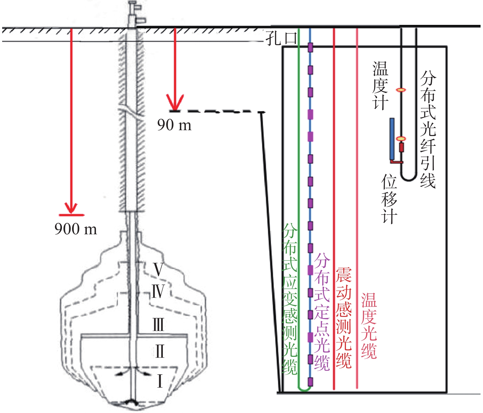
常州市金坛盐穴地下空间开发利用潜力巨大;尤其是盐穴储气库建设,已逐步形成规模,盐矿区内的地面沉降问题也逐步显露[20-23],所以对盐矿区盐穴造腔及储气腔体,进行全周期沉降变形监测变得尤为重要。
分布式光纤监测技术在地面沉降成因机理研究领域得到快速发展[8,10,24];其在针对盐穴腔体上方的地层应力场、位移场监测等方面优势显著,具有结构简单,施工和维护方便,性价比高等特点;能够连续、准确测出光纤所在地层的连续变形特征。因此,为实现腔体正上方岩土体沉降变形监测及预警功能,利用工程孔实现“一孔多用”,在盐矿区建立了腔体上覆岩土体移动变形监测站。在孔内布设了埋深90 m的垂向监测分布式光纤、温度感测光缆、地下水渗压计、FBG位移传感器,以及地表200 m水平跨腔体应变分布光纤路线。确保了对盐穴腔体上方地层应力应变、差异性沉降的多维度、周期性监测。本次布设两种分布式光纤:
(1)垂向分布式光纤监测方法:对腔体上覆土层垂向应力应变进行周期性监测;进而获取盐穴地下空间开发利用(造腔-储气)过程的压缩变形情况。孔内布设的震动感测光缆是为了对水溶造腔过程可能产生的微动进行监测,实现盐矿区地面沉降预警功能(图3)。
![]() 图 3 金坛盐穴腔体沉降变形监测传感器布设示意图Figure 3. Schematic view of sensors for settlement deformation monitoring at Jintan salt caverns
图 3 金坛盐穴腔体沉降变形监测传感器布设示意图Figure 3. Schematic view of sensors for settlement deformation monitoring at Jintan salt caverns(2)水平分布式光纤监测:通过地表差异性沉降造成水平布设的光纤产生拉伸变形,实现对差异性沉降位置的识别。
2.5 全区地下水位监测
深层地下水过量开采作为常州地面沉降主要诱发因素,决定了地下水水位是地面沉降防控必须考虑的基础监测内容[25-26];掌握区域地下水动态对地面沉降防治具有重要意义;是地面沉降监测网络的重要环节;也是常州市区地下水环境保护和地面沉降防治的基础工作。故本次监测网构建对以往地下水位监测井进行收集整合。目前,常州市共有86处地下水水位监测点(图2)。
综上所述,本次常州市区地面沉降监测网优化完善工作是在系统分析区域地质条件的基础上完成的;充分考虑了常州市区近年来的地面沉降形势,对重点沉降区域布设分层标和光纤监测孔,还进行多方法对比监测。所以,优化后的常州市区地面沉降监测网能够实现对区内地面沉降形势的精确有效监测,做到区域地面沉降“预防先行,未雨绸缪”。
3. 地面沉降发展趋势
3.1 总体沉降趋势
(1)年沉降速率
通过GPS-InSAR监测方法获取了常州市区2019年度沉降速率图(图4)可以看出:常州市中心原重点沉降区域已基本不沉降;现沉降中心为武进区前黄—礼嘉镇一带以及北部邹区镇附近;金坛区沉降中心位于儒林—新建镇一带,以及金坛盐矿区直溪镇汀湘村—大岸村一带。且现沉降中心规模也较小。全区稳定区域面积占比达到93%;年沉降速率≥20 mm/a的区域面积为3.5 km2,约占全区面积0.1%;见图4、图5。
![]() 图 4 常州市InSAR监测地面沉降速率图(2019年)注:形变负值表示地面沉降。Figure 4. InSAR monitoring land subsidence rate map of Changzhou City (2019)
图 4 常州市InSAR监测地面沉降速率图(2019年)注:形变负值表示地面沉降。Figure 4. InSAR monitoring land subsidence rate map of Changzhou City (2019)(2)累计沉降量
从2019年常州市地面沉降分布图可以看出:常州市区地面累计沉降量(1980—2019年)均超过200 mm的区域总面积约796 km2,占全区面积的28%;地面累计沉降量超过800 mm的区域主要分布于湖塘东、戚墅堰、横林、潞城、遥观、洛阳北一带,总面积约236 km2,占全区面积的8.3%。从累计沉降量分布图可以得出历史沉降中心基本与历史深层地下水位降落漏斗中心相对应,并与无锡洛社、祝塘连成一片,见图5。
3.2 常州市重点沉降区分布
(1)常州市区及前黄镇
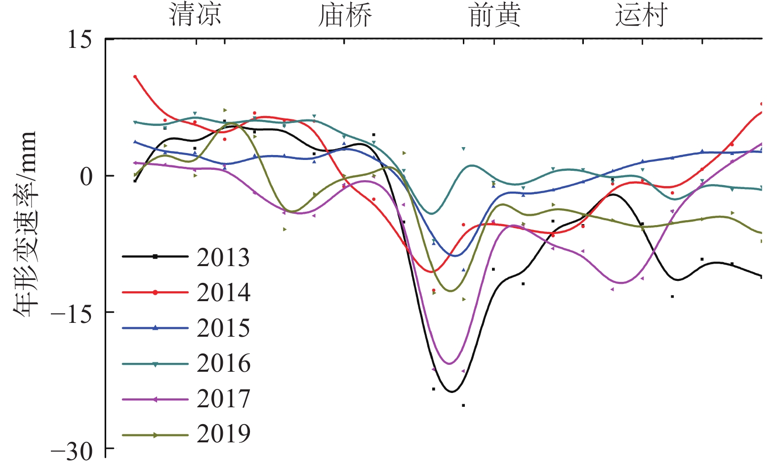
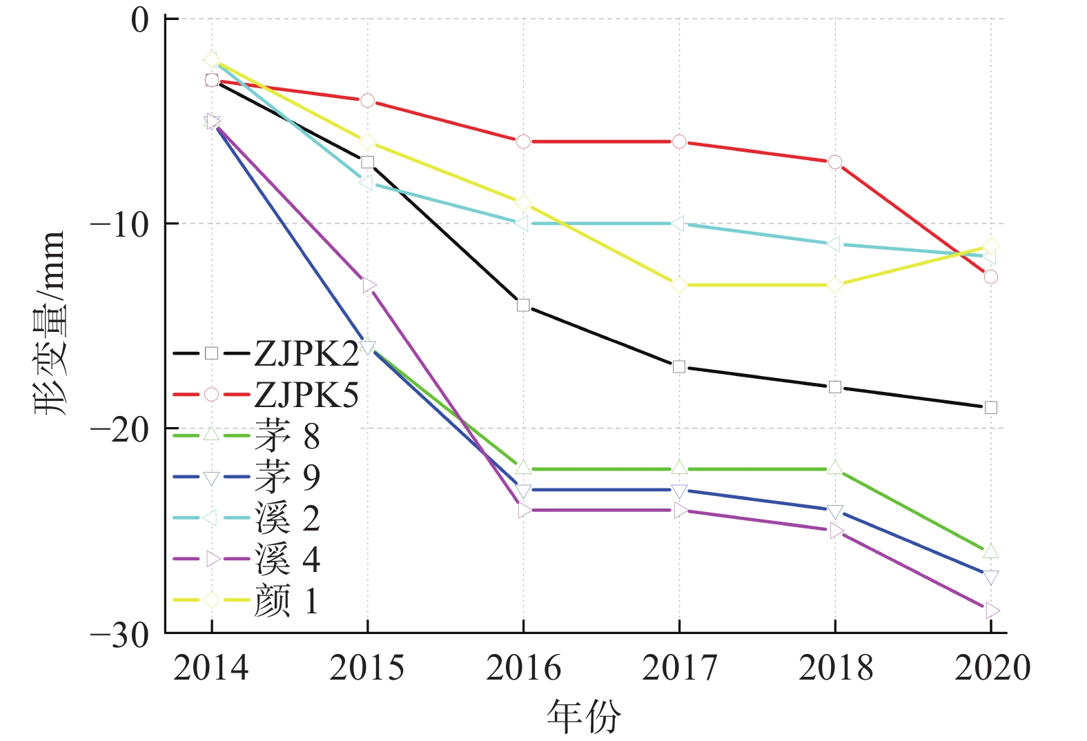
2013—2019年水准数据显示:常州主要沉降区域位于南夏墅—前黄镇一带。2016—2019年南北向水准路线(图2中A-A'-A'''水准路线),市区中心区域地面沉降现象基本消失,清凉路一带呈现地面回弹迹象明显;总之,原先位于市区的老沉降中心的沉降形势基本稳定;前黄礼嘉一带逐渐成为区内主要沉降区域,见图5、图6。
![]() 图 6 常州南北向水准监测数据(2013—2019年)注:形变负值表示沉降。Figure 6. Annual settlement deformation leveling data for north-south direction in Changzhou City from 2013 to 2019
图 6 常州南北向水准监测数据(2013—2019年)注:形变负值表示沉降。Figure 6. Annual settlement deformation leveling data for north-south direction in Changzhou City from 2013 to 2019(2)金坛区儒林镇
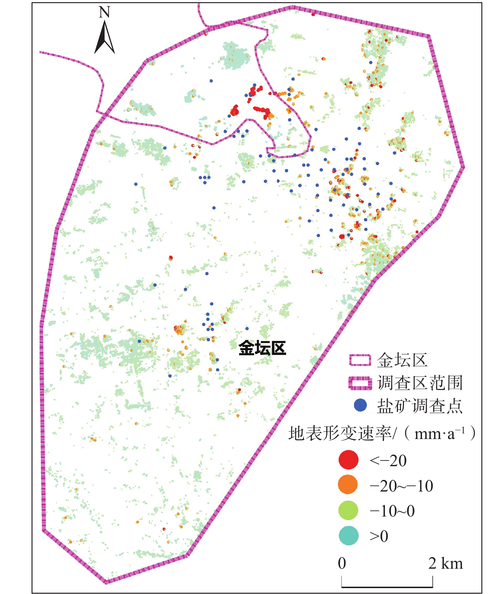
InSAR监测结果显示:金坛区儒林镇一带沉降情况为目前常州市最为严重的沉降区域。2019年沉降速率大于20 mm/年的区域主要位于金坛区儒林镇东南角,面积为3.5 km2,见图4、图5。
从时间上看,2017—2019年 INSAR监测数据获取的沉降特征表现为:夏季大幅沉降,冬季小幅回升的特点;经调查证实,儒林镇沉降区域夏季存在大规模水产养殖用水需求,当地水井密布,地下水开采量较大,见图7。从空间上看,儒林镇Ⅱ承压水位存在埋深在35 m以深的水位漏斗,且该水位漏斗与沉降漏斗的空间位置基本一致,见图8。因此,初步推测:中浅层地下水开采为儒林镇地面沉降的主要诱因。
![]() 图 7 常州儒林镇地面沉降演化(InSAR)注:形变量负值表示沉降。Figure 7. Evolution of land subsidence in Rulin Town, Changzhou City (InSAR)
图 7 常州儒林镇地面沉降演化(InSAR)注:形变量负值表示沉降。Figure 7. Evolution of land subsidence in Rulin Town, Changzhou City (InSAR)![]() 图 8 儒林Ⅱ承压水位埋深与沉降分布图Figure 8. Distribution map of settlement deformation and water level in Rulin Town, Changzhou City
图 8 儒林Ⅱ承压水位埋深与沉降分布图Figure 8. Distribution map of settlement deformation and water level in Rulin Town, Changzhou City(3)金坛盐矿区
InSAR监测数据显示:金坛区盐盆内直溪镇汀湘—大岸村一带,区内最大沉降位于鲍塘村—大岸村,最大沉降量超过30 mm/a;矿区盐穴腔体周边也存在缓慢沉降现象;年沉降速率在10 mm/a;沉降位置与盐穴造腔工程建设位置存在较好的对应关系,见图9。因此,不论从区域角度还是从单点出发,本区地面沉降与盐穴造腔都存在密切关联。
![]() 图 9 盐矿区InSAR监测地面沉降速率图(2017年)Figure 9. Land subsidence rate monitored by InSAR at salt mine area (2017)
图 9 盐矿区InSAR监测地面沉降速率图(2017年)Figure 9. Land subsidence rate monitored by InSAR at salt mine area (2017)2019年水准数据显示:盐矿区75个水准监测点中有12个监测点沉降量大于5 mm,其中包含4个盐井监测点;5个沉降量大于10 mm的监测点中有1个盐井监测点;此外部分盐穴老腔停采后,地表依旧会持续沉降,见图10。
![]() 图 10 盐矿区采盐井沉降演化Figure 10. Sedimentation evolution at monitoring leveling points in salt mine area
图 10 盐矿区采盐井沉降演化Figure 10. Sedimentation evolution at monitoring leveling points in salt mine area埋深为90 m的金坛盐矿垂向分布式光纤监测孔变形监测结果显示:在2020年8月—2021年3月,光纤孔变形总量约2.5 mm,监测层位属于持续压缩状态;主要变形层位于45~55 m泥岩段(图11)。根据位移计数据显示:16~20 m深度范围内,位移计累计变形为0.8 mm,与分布式光缆基本吻合;说明盐穴造腔过程地面沉降问题虽不显著,但依旧存在;需要给予足够重视,防患于未然。
3.3 重点沉降区变形层位
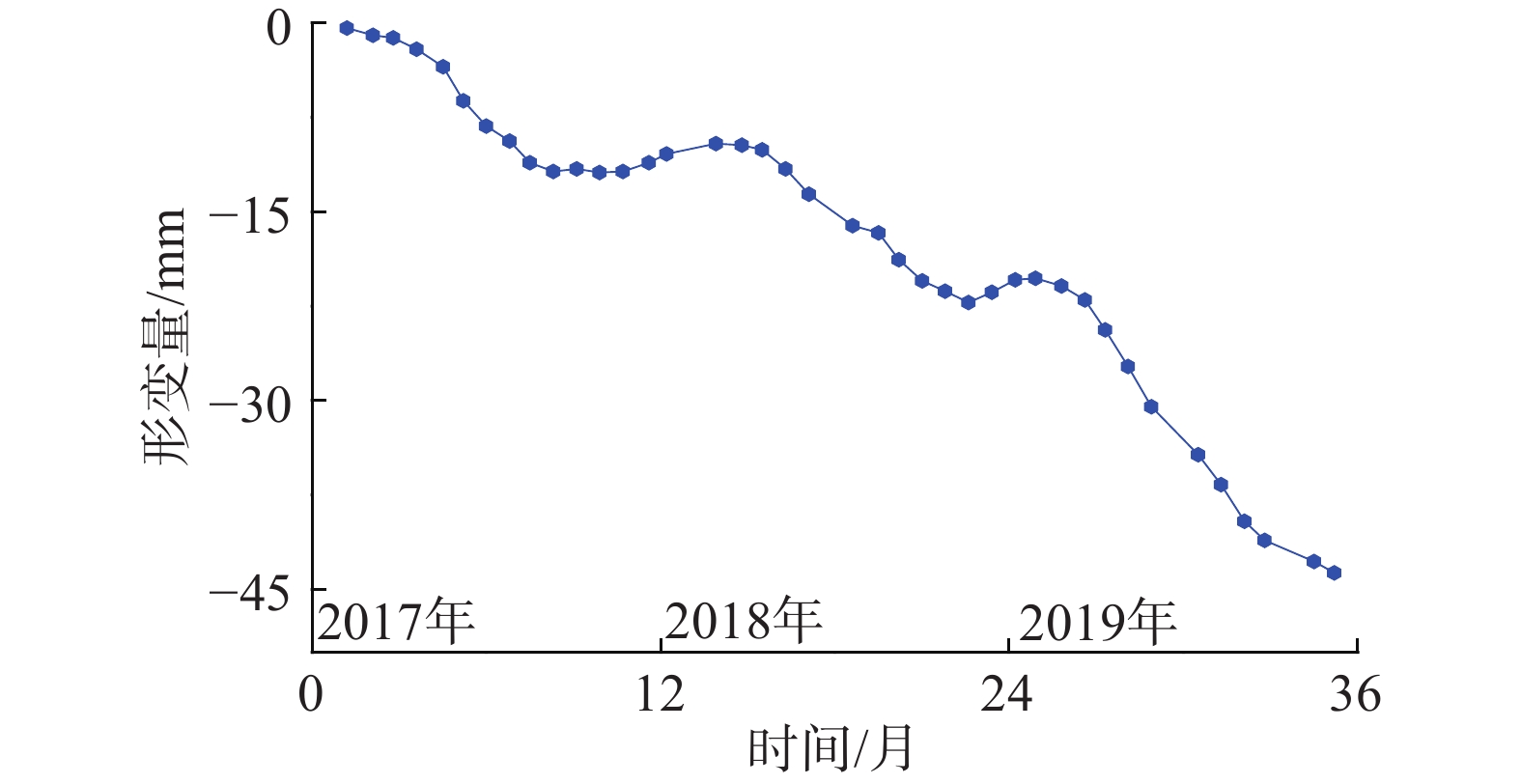
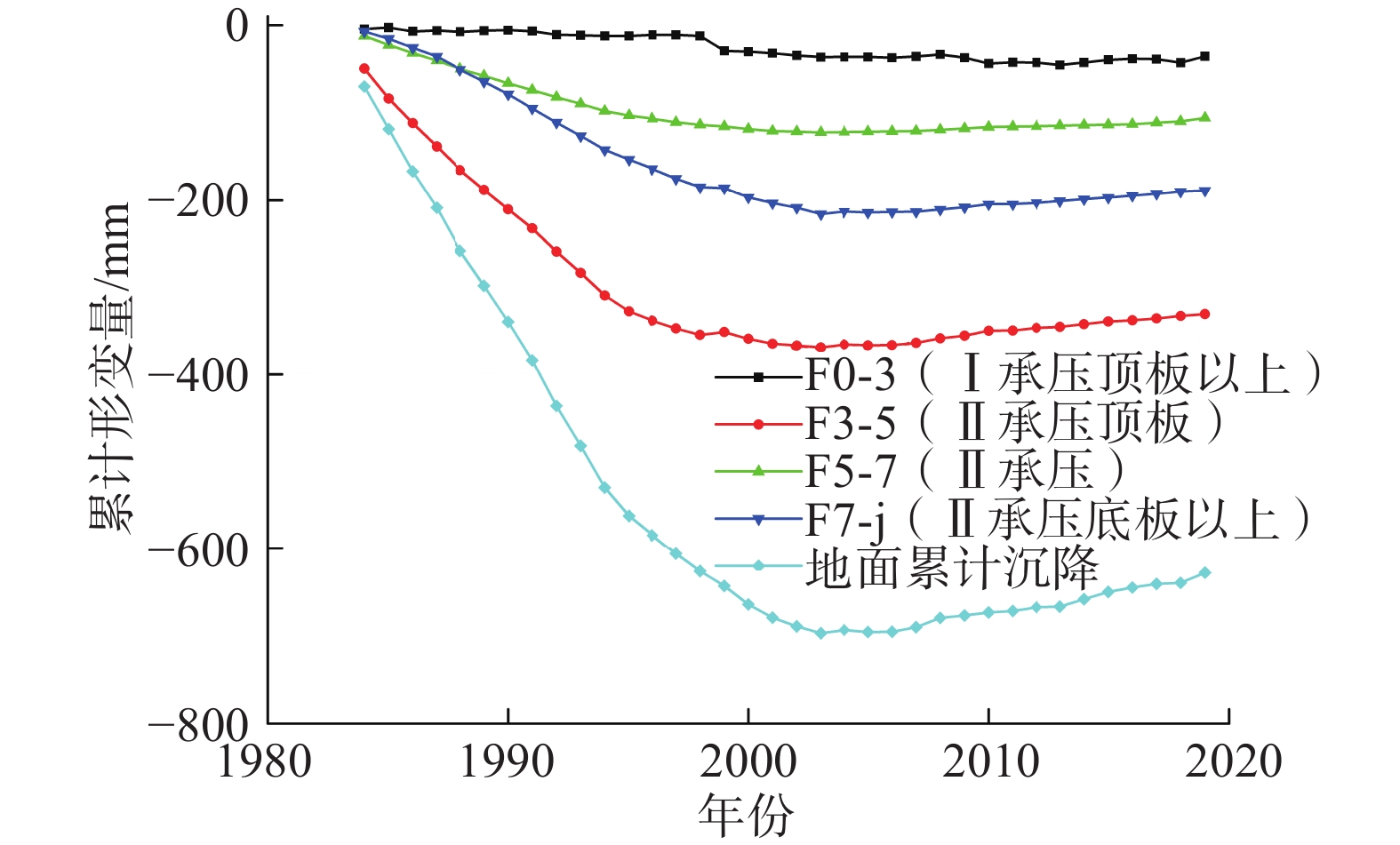
常州市区清凉小学一带曾经一度是本市地面沉降最严重区域,历来是监测与防治的重点。而监测网也为沉降漏斗区的成因机理研究提供了数据支撑。尤其是分层标监测数据在反映沉降中心的沉降(回弹)层位的变形特征时作用显著。根据常州市清凉小学分层标(图12)监测数据:
![]() 图 12 清凉小学分层标累计沉降情况Figure 12. The cumulative settlement of layerwise mark of Qingliang primary school
图 12 清凉小学分层标累计沉降情况Figure 12. The cumulative settlement of layerwise mark of Qingliang primary school1984—2004年,地面标累计沉降达到668 mm。而Ⅱ承压顶板黏性土层(F3与F5分标差)出现压缩量接近366 mm;F3—F5所在层位压缩量占整个地层压缩量的54.77%。第Ⅱ承压含水层所在位置(F5与F7分标差)出现压缩量接近79.11 mm;F3—F5所在层位压缩量占整个地层压缩量的12%。第Ⅲ承压含水层所在位置(F7与基岩标差值)出现压缩量接近213 mm;所在层位压缩量约占整个地层压缩量的30%;详见图12,表1。
表 1 1984—2020年土层累计压缩/回弹量统计表Table 1. Summary table of cumulative soil compression/ rebound measurements from 1984 to 2020地层层段 1984—2004年累计
压缩量/mm分层沉降
占比/%2004—2020年累计
回弹量/mm分层回弹
占比/%0~39 m 16.57 2.48 0 0 39~92 m 365.58 54.77 35 46.7 92~109 m 79.11 11.84 22 29.3 109 m 206.90 30.91 18 24.0 累计沉降 668.00 100.00 75 100.0 即禁采前,含水砂层及其顶板黏性土层的压缩量在地面沉降总量中约占75%左右,由此基本可以看出:禁采前,常州市区地面沉降的主要沉降层位为Ⅱ承压含水层及其顶板黏性土层。
2004年以后,随着地下水禁采措施的实施,市区Ⅱ承压水位恢复至50 m以浅[8-9];常州市区地面沉降形势得到有效缓解;局部地区甚至出现地面回弹现象。截至2019年,分层标数据也表明:地层逐渐出现回弹现象,地面累计回弹量累计接近80 mm。禁采后,Ⅱ承压与Ⅰ承压之间软弱土层的回弹占比达到46%,见图13,表1。可以初步得出:该处地面回弹与是由于II承压含水层较快恢复,II承压含水层及软弱土层发生回弹导致。深部地层多数处于反弹阶段,而浅部地层是当前主要压缩层位。说明:禁采后,浅部地层土层压缩已成为常州市地面沉降的主要影响因素。
![]() 图 13 常州市清凉小学分层标回弹情况注:回弹量为负值表示沉降。Figure 13. Stratified standard rebound of layered marks at Qingliang primary school
图 13 常州市清凉小学分层标回弹情况注:回弹量为负值表示沉降。Figure 13. Stratified standard rebound of layered marks at Qingliang primary school总体来说,优化后沉降监测网络的获取的结果显示:常州总体形势趋于稳定;原沉降中心区域已无明显沉降迹象,但儒林一带、武进南部等地局部区域,依旧存在相对明显的沉降现象。监测数据对地面沉降层位确定等成因机理研究工作也提供了详实的数据支撑。综上所述,常州市地面沉降防治取得了显著的成效;优化完善后的常州市地面沉降监测网络能够全面、准确地满足当前形势下区内的地面沉降监测要求。
4. 结论与建议
常州市地面沉降监测网建设全面考虑了地面沉降与地下水开发利用现状、区域地质条件,综合运用了多种监测技术,建成了区域控制与重点监测相结合的地面沉降监测网。而地面沉防治是一项长期持续的工作,今后在常州市开展地面沉降防控还需注意以下几点:
(1) 常州地面沉降形势总体趋于稳定,全区稳定区域面积占比达到93%。仅儒林一带、武进南部及金坛盐矿区等地局部地区依旧存在沉降迹象。常州市地面沉降取得了显著的防治成效,但还需坚持完善城市地面沉降监测网,及时调整沉降监测重点。重点加强前黄镇、儒林镇、金坛盐矿区等地的地面沉降形势,实现城市地面沉降监测与防控的准确性、时效性。
(2) 金坛区儒林镇中浅层地下水开采诱发的局部地面沉降问题应得到相应重视,建议加强浅层地下水水位监控,避免地下水开采加剧区域性沉降。
(3) 目前,金坛盐矿区地面沉降问题虽不显著,但依旧存在。该区局部沉降原因初步推测为:盐岩开采过程,上覆岩土体移动变形传递至地表形成的,需要给予足够重视,防患于未然。
(4) 2000年苏南深层地下水禁采措施实施后,常州地区地下水位回升,地面沉降得到有效控制,局部地区甚至出现了回弹。而地下水本身也是一种资源,在新时期可以在局部地区尝试探索水资源开采与地面沉降防控之间的平衡,实现地面沉降有效控制与地下水资源合理开发多种资源协同利用。
-
![]()
图 1 常州市地面沉降及地下水位历史演化
Figure 1. Historical evolution of land subsidence and groundwater level in Changzhou City
![]()
图 2 常州市地面沉降监测工作部署图
Figure 2. Field work deployment map of land subsidence monitoring in Changzhou City
![]()
图 3 金坛盐穴腔体沉降变形监测传感器布设示意图
Figure 3. Schematic view of sensors for settlement deformation monitoring at Jintan salt caverns
![]()
图 4 常州市InSAR监测地面沉降速率图(2019年)
注:形变负值表示地面沉降。
Figure 4. InSAR monitoring land subsidence rate map of Changzhou City (2019)
![]()
图 6 常州南北向水准监测数据(2013—2019年)
注:形变负值表示沉降。
Figure 6. Annual settlement deformation leveling data for north-south direction in Changzhou City from 2013 to 2019
![]()
图 7 常州儒林镇地面沉降演化(InSAR)
注:形变量负值表示沉降。
Figure 7. Evolution of land subsidence in Rulin Town, Changzhou City (InSAR)
![]()
图 8 儒林Ⅱ承压水位埋深与沉降分布图
Figure 8. Distribution map of settlement deformation and water level in Rulin Town, Changzhou City
![]()
图 9 盐矿区InSAR监测地面沉降速率图(2017年)
Figure 9. Land subsidence rate monitored by InSAR at salt mine area (2017)
![]()
图 10 盐矿区采盐井沉降演化
Figure 10. Sedimentation evolution at monitoring leveling points in salt mine area
![]()
图 12 清凉小学分层标累计沉降情况
Figure 12. The cumulative settlement of layerwise mark of Qingliang primary school
![]()
图 13 常州市清凉小学分层标回弹情况
注:回弹量为负值表示沉降。
Figure 13. Stratified standard rebound of layered marks at Qingliang primary school
表 1 1984—2020年土层累计压缩/回弹量统计表
Table 1 Summary table of cumulative soil compression/ rebound measurements from 1984 to 2020
地层层段 1984—2004年累计
压缩量/mm分层沉降
占比/%2004—2020年累计
回弹量/mm分层回弹
占比/%0~39 m 16.57 2.48 0 0 39~92 m 365.58 54.77 35 46.7 92~109 m 79.11 11.84 22 29.3 109 m 206.90 30.91 18 24.0 累计沉降 668.00 100.00 75 100.0  下载: 导出CSV
-
[1] Emery T Cleaves, Issues of scale, geology and urban development[C]. Geological Society of America, Northeastern Section, 38th Annual Meeting, March 2004, 36( 2) : 41.
[2] N.Subba Rao. R.Prathap Reddy. Geoenvironmental appraisal in a developing urban area[J]. Environmental Geology, 2004, 47(1): 20-29.
[3] 李伟,武健强. 苏锡常地区地面沉降监测方法体系建设[J]. 世界地质,2015,34(3):862 − 869. [LI Wei,WU Jianqiang. Research on monitoring method system of land subsidence in Suzhou-Wuxi-Changzhou area[J]. Global Geology,2015,34(3):862 − 869. (in Chinese with English abstract) DOI: 10.3969/j.issn.1004-5589.2015.03.035 [4] 缪晓图,朱兴贤,陆美兰,等. 苏锡常地区Ⅱ承压水开采与地面沉降控制研究[J]. 中国地质灾害与防治学报,2007,18(2):132 − 139. [MIAO Xiaotu,ZHU Xingxian,LU Meilan,et al. Groundwater exploration from the confined aquiferous Ⅱ and land subsidence control of Suxichang area[J]. The Chinese Journal of Geological Hazard and Control,2007,18(2):132 − 139. (in Chinese with English abstract) DOI: 10.3969/j.issn.1003-8035.2007.02.026 [5] 于军. 苏锡常地区地面沉降监测网络体系建设初探[J]. 中国地质灾害与防治学报,2000,11(3):82 − 85. [YU Jun. Preliminary design of establishment of land subsidence monitoring network system in Suzhou-Wuxi-Changzhou(Su-Xi-Chang) area[J]. The Chinese Journal of Geological Hazard and Control,2000,11(3):82 − 85. (in Chinese with English abstract) DOI: 10.3969/j.issn.1003-8035.2000.03.020 [6] 郭海朋,李文鹏,王丽亚,等. 华北平原地下水位驱动下的地面沉降现状与研究展望[J]. 水文地质工程地质,2021,48(3):162 − 171. [GUO Haipeng,LI Wenpeng,WANG Liya,et al. Present situation and research prospects of the land subsidence driven by groundwater levels in the North China Plain[J]. Hydrogeology & Engineering Geology,2021,48(3):162 − 171. (in Chinese with English abstract) DOI: 10.16030/j.cnki.issn.1000-3665.202012037 [7] 王双,严学新,揭江,等. 珠江三角洲平原区地面沉降影响因素分析[J]. 中国地质灾害与防治学报,2019,30(5):98 − 104. [WANG Shuang,YAN Xuexin,JIE Jiang,et al. Analysis on factors affecting ground settlement in plain area of Pearl River Delta[J]. The Chinese Journal of Geological Hazard and Control,2019,30(5):98 − 104. (in Chinese with English abstract) DOI: 10.16031/j.cnki.issn.1003-8035.2019.05.13 [8] 顾春生, 杨磊, 武健强, 等. 常州城市地质调查地质灾害调查与评价专题报告[R]. 南京: 江苏省地质调查研究院. 2020. GU Chunsheng, YANG Lei, WU Jianqiang, et al. Report on geological hazard investigation and evaluation of Changzhou urban geological survey [R]. Nanjing: Geological Survey of Jiangsu Province. 2020. (in Chinese)
[9] 杨磊, 崔龙玉, 唐鑫, 等. 常州城市地质调查报告[R]. 南京: 江苏省地质调查研究院. 2021. YANG Lei, CUI Longyu, TANG Xin, et al. Report of Changzhou urban geological survey[R]. Nanjing: Geological Survey of Jiangsu Province. 2021.(in Chinese)
[10] 顾春生. 苏锡常地区采水型地裂缝发育演化规律试验研究[D]. 徐州: 中国矿业大学, 2017 GU Chunsheng. Experimental study on the development and evolution of ground fissures caused by extraction of groundwater in Suzhou-wuxichangzhou region[D]. Xuzhou: China University of Mining and Technology, 2017. (in Chinese with English abstract)
[11] 顾晟彦,姚维军,徐明钻,等. 江苏盐城地面沉降风险评价[J]. 中国地质灾害与防治学报,2020,31(1):36 − 43. [GU Shengyan,YAO Weijun,XU Mingzuan,et al. Risk evaluation of land subsidence in Yancheng of Jiangsu Province[J]. The Chinese Journal of Geological Hazard and Control,2020,31(1):36 − 43. (in Chinese with English abstract) DOI: 10.16031/j.cnki.issn.1003-8035.2020.01.06 [12] 蔡田露,龚绪龙,卢毅,等. 江苏沿海地区InSAR精度评定与多源数据验证[J]. 遥感技术与应用,2020,35(6):1426 − 1435. [CAI Tianlu,GONG Xulong,LU Yi,et al. Accuracy assessment and multi-source data validation of InSAR in Jiangsu coastal area[J]. Remote Sensing Technology and Application,2020,35(6):1426 − 1435. (in Chinese with English abstract) [13] 孔祥如,罗勇,刘贺,等. PS-InSAR技术在北京通州区地面沉降监测中的应用[J]. 城市地质,2021,16(1):25 − 31. [KONG Xiangru,LUO Yong,LIU He,et al. Application of PS-InSAR technology in the land subsidence survey in Tongzhou District,Beijing[J]. Urban Geology,2021,16(1):25 − 31. (in Chinese with English abstract) DOI: 10.3969/j.issn.1007-1903.2021.01.004 [14] 王商富. PS-InSAR技术在福州市建筑物沉降监测中的应用研究[J]. 测绘与空间地理信息,2022,45(1):67 − 70. [WANG Shangfu. Application research of PS-InSAR technology on building subsidence monitoring in Fuzhou[J]. Geomatics & Spatial Information Technology,2022,45(1):67 − 70. (in Chinese with English abstract) DOI: 10.3969/j.issn.1672-5867.2022.01.017 [15] 何健辉,张进才,陈勇,等. 基于弱光栅技术的地面沉降自动化监测系统[J]. 水文地质工程地质,2021,48(1):146 − 153. [HE Jianhui,ZHANG Jincai,CHEN Yong,et al. Automatic land subsidence monitoring system based on weak-reflection fiber gratings[J]. Hydrogeology & Engineering Geology,2021,48(1):146 − 153. (in Chinese with English abstract) DOI: 10.16030/j.cnki.issn.1000-3665.201912053 [16] 江苏省人民代表大会常务委员会. 江苏省人民代表大会常务委员会关于在苏锡常地区限期禁止开采地下水的决定[J]. 江苏水利,2000(10):9. [The Standing Committee of Jiangsu Provincial People's Congress. Decision of the Standing Committee of Jiangsu Provincial People’s Congress on banning the exploitation of groundwater within a time limit in Suzhou,Wuxi and Changzhou areas[J]. Jiangsu Water Resources,2000(10):9. (in Chinese with English abstract) [17] 许才军, 王华, 黄劲松. GPS与INSAR数据融合研究展望[J]. 武汉大学学报(信息科学版), 2003, 28(增刊1): 58 − 61 XU Caijun, WANG Hua, HUANG Jinsong. Prospect on the integration of GPS and INSAR data[J]. Geomatics and Information Science of Wuhan University, 2003, 28(Sup 1): 58 − 61. (in Chinese with English abstract)
[18] GABRIEL A K,GOLDSTEIN R M,ZEBKER H A. Mapping small elevation changes over large areas:differential radar interferometry[J]. Journal of Geophysical Research,1989,94(B7):9183. DOI: 10.1029/JB094iB07p09183
[19] HU Jun,LI Zhiwei,DING Xiaoli,et al. Two-dimensional Co-seismic surface displacements field of the Chi-Chi earthquake inferred from SAR image matching[J]. Sensors (Basel,Switzerland),2008,8(10):6484 − 6495. DOI: 10.3390/s8106484
[20] 张艺. 金坛盐矿老腔改建储气库可行性研究[D]. 重庆: 重庆大学, 2011 ZHANG Yi. Research on feasibility of old cavity rebuild to gas storage in Jintan salt mines[D]. Chongqing: Chongqing University, 2011. (in Chinese with English abstract)
[21] 杨春和,梁卫国,魏东吼,等. 中国盐岩能源地下储存可行性研究[J]. 岩石力学与工程学报,2005,24(24):4409 − 4417. [YANG Chunhe,LIANG Weiguo,WEI Donghou,et al. Investigation on possibility of energy storage in salt rock in China[J]. Chinese Journal of Rock Mechanics and Engineering,2005,24(24):4409 − 4417. (in Chinese with English abstract) DOI: 10.3321/j.issn:1000-6915.2005.24.002 [22] 完颜祺琪,冉莉娜,韩冰洁,等. 盐穴地下储气库库址地质评价与建库区优选[J]. 西南石油大学学报(自然科学版),2015,37(1):57 − 64. [WANYAN Qiqi,RAN Lina,HAN Bingjie,et al. Study on site selection and evaluation of underground gas storage in salt cavern[J]. Journal of Southwest Petroleum University (Science & Technology Edition),2015,37(1):57 − 64. (in Chinese with English abstract) [23] 丁国生. 金坛盐穴地下储气库建库关键技术综述[J]. 天然气工业,2007,27(3):111 − 113. [DING Guosheng. General introduction on key technologies of the construction of Jintan underground salt cavern gas storage[J]. Natural Gas Industry,2007,27(3):111 − 113. (in Chinese with English abstract) DOI: 10.3321/j.issn:1000-0976.2007.03.037 [24] 卢毅,施斌,席均,等. 基于BOTDR的地裂缝分布式光纤监测技术研究[J]. 工程地质学报,2014,22(1):8 − 13. [LU Yi,SHI Bin,XI Jun,et al. Field study of botdr-based distributed monitoring technology for ground fissures[J]. Journal of Engineering Geology,2014,22(1):8 − 13. (in Chinese with English abstract) DOI: 10.3969/j.issn.1004-9665.2014.01.002 [25] 余成,葛伟亚,贾军元,等. 苏南地区地质灾害区划评价[J]. 中国地质调查,2019,6(5):131 − 136. [YU Cheng,GE Weiya,JIA Junyuan,et al. Regionalization and assessment of the geological hazard areas in south Jiangsu[J]. Geological Survey of China,2019,6(5):131 − 136. (in Chinese with English abstract) DOI: 10.19388/j.zgdzdc.2019.05.15 [26] 龚绪龙,杨蕴,朱锦旗,等. 苏南平原区地裂缝现状及其需要解决的几个问题[J]. 中国地质灾害与防治学报,2015,26(2):103 − 109. [GONG Xulong,YANG Yun,ZHU Jinqi,et al. Ground fissures in south plain of Jiangsu Province and related issues[J]. The Chinese Journal of Geological Hazard and Control,2015,26(2):103 − 109. (in Chinese with English abstract) DOI: 10.16031/j.cnki.issn.1003-8035.2015.02.18 -
期刊类型引用(16)
1. 夏璐文,徐佳,肖儒雅,潘伯鸣,孙雪梅. 基于时序InSAR技术的常州市地表形变监测与影响因素分析. 测绘工程. 2025(01): 53-61 .  百度学术
百度学术
2. 李健,杨卓,李岩. 某山区机场跑道沉降监测和预测分析. 广州建筑. 2025(01): 87-90 . 百度学术
3. 王浩,徐俊辉,陆佳敏,张高,罗淼,赵云松,王卫东,徐孜俊,戴秋霞,陈留平,王同涛. 大规模地质储氢工程现状及应用展望. 中国地质. 2025(01): 180-204 . 百度学术
4. 刘鹏. 新一轮找矿突破战略行动背景下地质调查发展路径. 世界有色金属. 2024(04): 93-95 . 百度学术
5. 刘伯元,王婷婷,陈慧玲. 刍议数字时代地勘行业参与生态文明建设路径. 世界有色金属. 2024(04): 182-184 . 百度学术
6. 王东仓,何景媛. 创新金融模式下生态保护修复路径探析. 世界有色金属. 2024(06): 147-149 . 百度学术
7. 刘鹏. 创新视角下的生态保护修复探讨. 世界有色金属. 2024(08): 174-176 . 百度学术
8. 刘栋永. 地勘行业战略转型背景下科学事业单位项目成本核算探究. 世界有色金属. 2024(08): 181-183 . 百度学术
9. 陈一超,赵文博. 基于地质调查转型发展背景下创新技术应用探讨. 世界有色金属. 2024(08): 188-191 . 百度学术
10. 亓国涛,王荣,高晓琦. 地勘单位参与生态修复行业高质量发展的路径探析. 世界有色金属. 2024(10): 178-181 . 百度学术
11. 陈浩,吴红刚,谌清. 基于“D”型深孔测斜曲线的滑坡滑动面位置确定方法研究. 中国地质灾害与防治学报. 2024(04): 93-105 . 本站查看
12. 王婷婷,刘伯元,孔萌. 浅析矿山生态修复治理存在问题及治理方向. 世界有色金属. 2024(14): 102-104 . 百度学术
13. 张婉娜,高乃昌. 数据可视化背景下生态修复规划实现路径. 世界有色金属. 2024(14): 190-192 . 百度学术
14. 李学良,李宏艳,白国良,李大猛,余洋. 深部条带老采空区覆岩破坏多参量监测研究. 矿业安全与环保. 2024(04): 156-161+167 . 百度学术
15. 李长山,迟帅. 基于时序InSAR遥感监测的中山市软土地面沉降特征及成因研究. 地质灾害与环境保护. 2024(04): 31-38 . 百度学术
16. 孙雪梅,潘伯鸣,李伟,夏璐文. 常州市主城区地表形变控制区划分及防控研究. 现代测绘. 2024(S1): 49-52 . 百度学术
其他类型引用(1)


计量
- 文章访问数: 2663
- HTML全文浏览量: 2175
- PDF下载量: 376
- 被引次数: 17
 邮件订阅
邮件订阅 RSS
RSS