

Hazard zoning and assessment of rockfalls based on AHP-3DEC
-
摘要: 山区高速铁路受线路平顺性及地形的限制,部分危岩发育地段无法绕避,给工程建设及运营安全提出了严峻挑战。文章在无人机三维倾斜摄影的基础上利用数字地质调绘技术对拟建济南至枣庄铁路杏花峪隧道进口危岩体的发育特征、规模、变形破坏模式进行了准确的判识,通过将3DEC数值模拟与层次分析法结合,获得了崩塌落石的影响范围和危险性分区图,开展了危险性分区评价,提出了防治措施。研究表明:三维倾斜摄影模型识别出的12处危岩带中,只有5号危岩带威胁隧道洞口和桥台安全,并建议采用“被动防护网+明洞”方式进行综合防治。研究成果为危岩落石灾害的危险性分区评价提供参考,为铁路选线及防灾减灾提供依据。Abstract: Restricted by the surface smoothness and topography, it is impossible for some high-speed railways on mountainous regions to avoid parts of rockfall development sections, posing great safety challenges to construction projects and railway operations. In light of that, this paper laid its focus on the rockfall situated by the entrance of Xinghuayu Tunnel along the proposed Jinan-Zaozhuang Railway project, and leveraged the power of drone-captured 3D aerial photography to perform digital geological survey and mapping so as to accurately identify the development characteristics, scale, as well as modes of deformation and failure of said rockfall. Next, by cross-referencing the results of 3DEC numerical simulation with those from analytic hierarchy process (AHP), color-coded maps highlighting the scope of influence and danger levels of potential rockfalls induced were obtained. Using said maps, zone-by-zone hazard and risk assessment were then performed, based on which corresponding prevention and control measures were put forward. The findings show that among the 12 dangerous rock belts identified from the drone-captured 3D aerial photography model, only Belt No. 5 would threaten the safety of the tunnel entrance and bridge abutments, for which the combination of anti-rockfall passive protective netting and an open-cut tunnel structure was recommended as a comprehensive solution. By virtue of the solution’s effectiveness, this study can offer reliable references for not only zone-by-zone hazard and risk assessment for rockfalls, but also railway route selection and disaster prevention and mitigation.
-
0. 引言
近年来,高速铁路的快速发展对线路的安全性提出了更高的要求。山区铁路受线路平顺性及地形的限制,部分危岩发育地段无法绕避,而危岩形成的崩塌落石灾害给工程建设及运营安全提出了严峻挑战[1-4]。同时,频发的危岩落石灾害也严重威胁着人民生命财产安全,例如:2009年7月25日,都江堰—汶川公路的彻底关大桥被落石冲击受损,造成人员伤亡,道路切断[5];2013年贵州省发生大规模山体崩塌,崩塌体掩埋房屋数间,灾害造成5人失踪,转移安置21户79人[6];2021年4月23日,重庆城口县国道G211龙田段发生危岩垮塌,造成国道封锁;可见,危岩一旦演化成崩塌落石,造成的危害和损失将不可挽回,因此危岩落石灾害的危险性分区评价对拟建工程尤为重要。
国外较早地对崩塌落石灾害展开了研究,危岩落石危险性分区分级系统和评价方法已较为完善[7-8]。Hasegawa等[9]基于数字高程模型(DEM)提出了一种计算铁路线路崩塌落石风险的方法。Fanos[10]基于激光扫描数据和GIS三维建模技术提出了一种危岩落石危险性的评价方法。
国内学者对灾害的研究起步较晚,但发展迅速,在崩塌落石灾害危险性分区与评价方面取得了一定的成果。叶四桥等[11-12]提出了危岩危险度AHP-Fuzzy综合评价方法,同时定义了隧道洞口坡段落石灾害危险性分级指标来对危岩落石危险性等级进行综合评价,为危岩落石危险性的研究做出了巨大贡献;唐红梅等[13-14]基于GIS技术获得了三峡库区的重庆巫山县的崩塌灾害危险性分区评价图,并通过层次分析法及模糊综合评价法建立了三峡库区灰岩地区崩塌体危险性模糊综合评价模型;高买燕等[15]通过RocFall数值模拟并结合层次分析法建立崩塌灾害危险性评价方法,将崩塌区分为极高危险、高危险、中危险和低危险4个等级;巩尚卿等[16]从灾害发生可能性与灾害致灾严重性建立了落石灾害危险性概率评价方法;武中鹏等[17]根据蒙特卡洛法计算不同工况下危岩的失稳概率,根据Rockfall模拟出来的落石轨迹确定了落石的影响范围并对影响区进行危险度的划分。
随着无人机航测技术在危岩落石勘察中的应用[18],不仅提高了野外勘察的工作效率和精度[19],也让高陡危岩的准确判识成为可能,从而提高危岩落石危险性分区的准确性。本文以拟建济南至枣庄高速铁路杏花峪隧道进口边坡危岩为例,通过采用无人机三维倾斜摄影技术,结合地质数字调绘,对危岩体范围及结构特征进行了准确判识,制作了大比例尺工程地质剖面图。通过3DEC数值模拟结合层次分析法制作了研究区危岩落石危险性分区云图,并提出经济合理的防治对策。研究成果可为铁路选线、崩塌落石灾害治理提供设计依据。
1. 研究区工程地质概况
研究区位于华北台地的鲁西断块,以古生代地层为主体的北倾单斜构造,无褶皱及断裂构造与隧道相交。铁路线路总体走向为南北向,地势北高南低,区域地貌属鲁中南中低山丘陵区。研究区上覆第四系全新统人工填土(
${{{{\rm{Q}}}}}{{\rm{h}}}^{ml}$ )、第四系冲洪积物(${{\rm{Q}}}{{\rm{h}}}^{al+pl}$ )、第四系坡残积物(${{\rm{Q}}}{{\rm{h}}}^{dl+el}$ ),下伏基岩为早元古代傲徕山期摩天岭单元花岗岩($ {M\eta \gamma }_{2}^{1-1b} $ )。研究区属暖温带半湿润区的大陆性季风气候,年平均气温14.3 °C,年平均降水量671.1 mm(1971—2000年)。地震动峰值加速度为0.10 g,基本地震动加速度反应谱特征周期为0.45 s。2. 危岩体的工程地质特征
2.1 危岩的发育特征
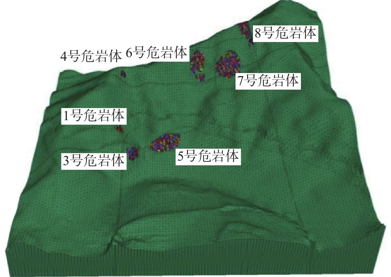
杏花峪隧道进口斜坡具有坡体陡峻、植被茂密、危岩体隐蔽性高、辨识难度大的特点,因此本文采用无人机航拍来建立该隧道进口边坡的三维实景影像(图1),共判识12处较为明显的危岩带(图2)。
通过三维倾斜摄影模型在三维倾斜摄影模型中利用Acute 3D Viewer软件的坐标、距离、体积测量功能,获得了对铁路工程威胁较大的7处典型危岩体(图3)体积、落石块径大小、与铁路轨面的相对高度等信息,分析结果见表1。
表 1 危岩带基本特征Table 1. Basic characteristics and scale of rockfall分带编号 危岩体体积/m³ 落石块径/m 相对高度/m 破坏模式 WY-01 12.12 0.2~1.12 44~48 滑移式 WY-03 960 0.4~1.3 0~10 坠落式 WY-04 1.4 0.5 114 滑移式 WY-05 73.2 0.3~1.3 5 坠落式 WY-06 736 0.8~4.3 121~146 倾倒式 WY-07 1 600 0.2~2.2 109~149 倾倒式 WY-08 1 823 0.14~2.12 156~198 倾倒式、滑移式 经判别杏花峪隧道进口危岩体属低位−特高位、小型−大型危岩体,存在倾倒、滑移、坠落三种破坏形式,局部发生失稳崩塌,并形成崩塌堆积体(图2)。
2.2 危岩体结构特征
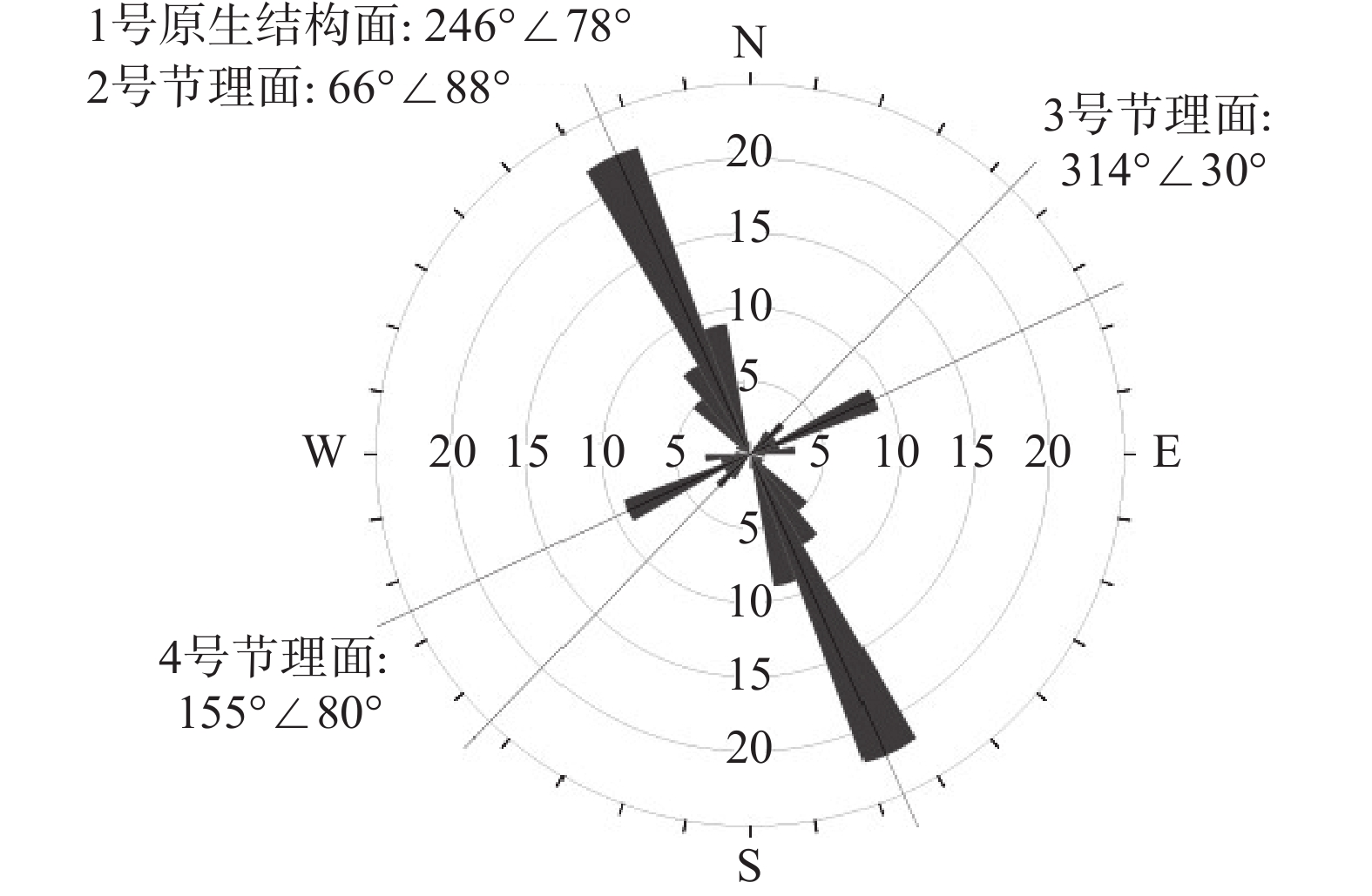
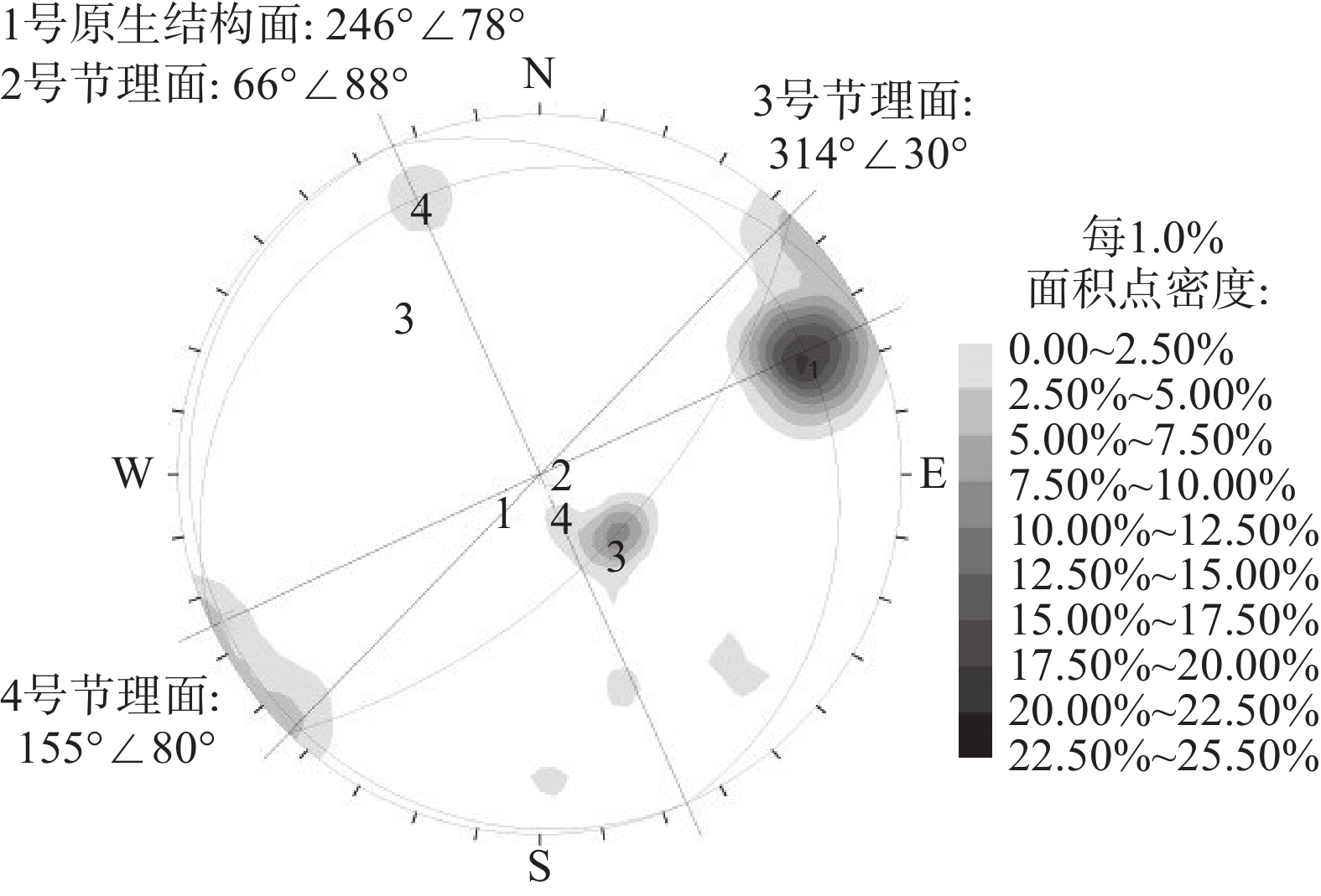
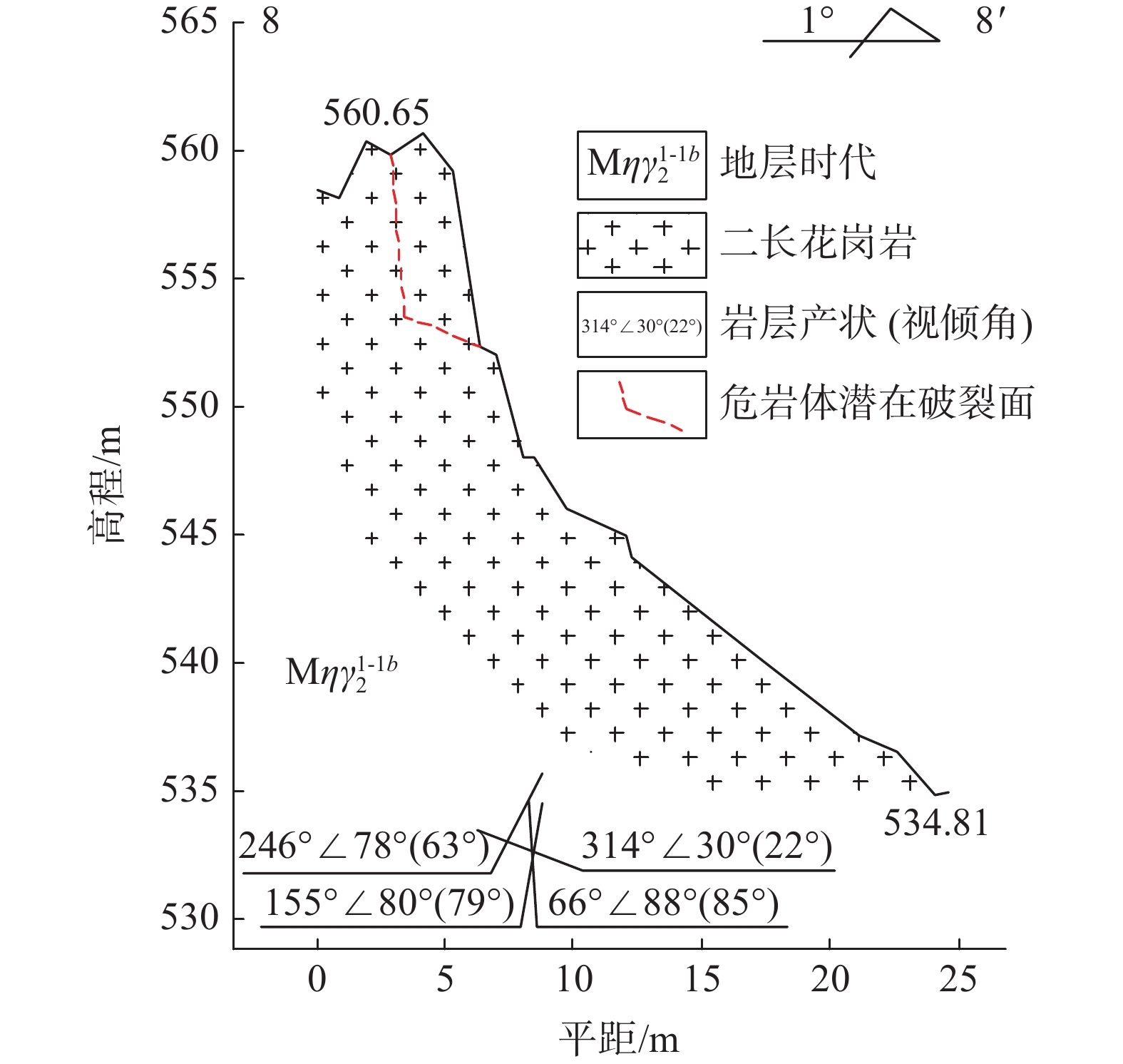
研究区地层岩性较为单一为花岗岩,但斜坡植被茂密、坡面陡峻,采用传统地质测绘的方式较为困难。故通过无人高精度遥感测量,并提取优势结构面特征点的三维坐标数据拟合结构面,共得到93条结构面产状信息。通过统计这93条节理裂隙,共拟合4组优势结构面(图4、图5、表2):246°∠78°、66°∠88°、314°∠30°、155°∠80°。
![]() 图 5 危岩体结构面点密度等值线图(下半球)Figure 5. Contour map of structural point density(lower hemisphere)表 2 结构面基本特征Table 2. Basic characteristics of joint surface
图 5 危岩体结构面点密度等值线图(下半球)Figure 5. Contour map of structural point density(lower hemisphere)表 2 结构面基本特征Table 2. Basic characteristics of joint surface结构面编号 产状 延伸长度
/m间距
/m起伏度 张开或
闭合充填情况 1号原生
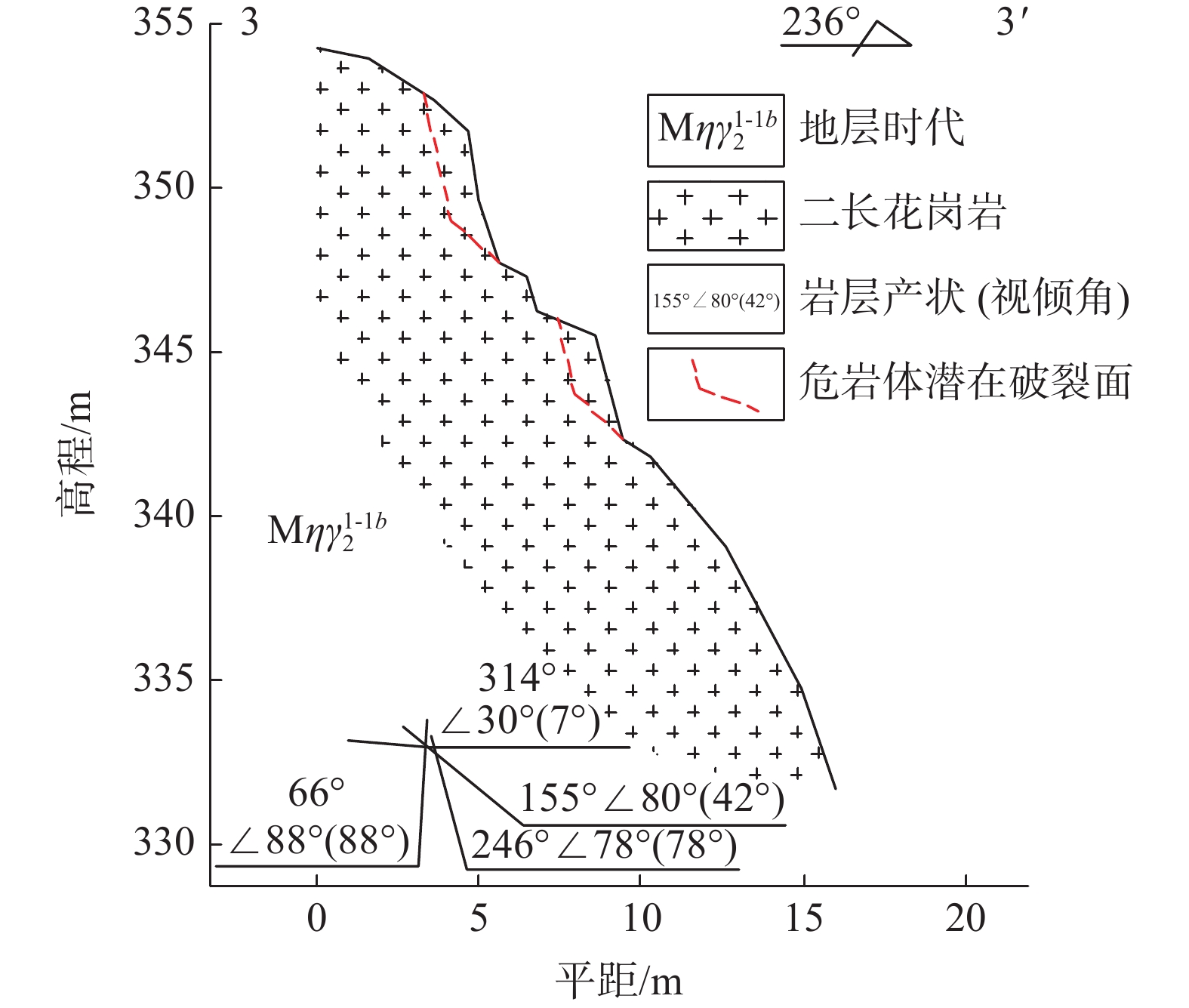
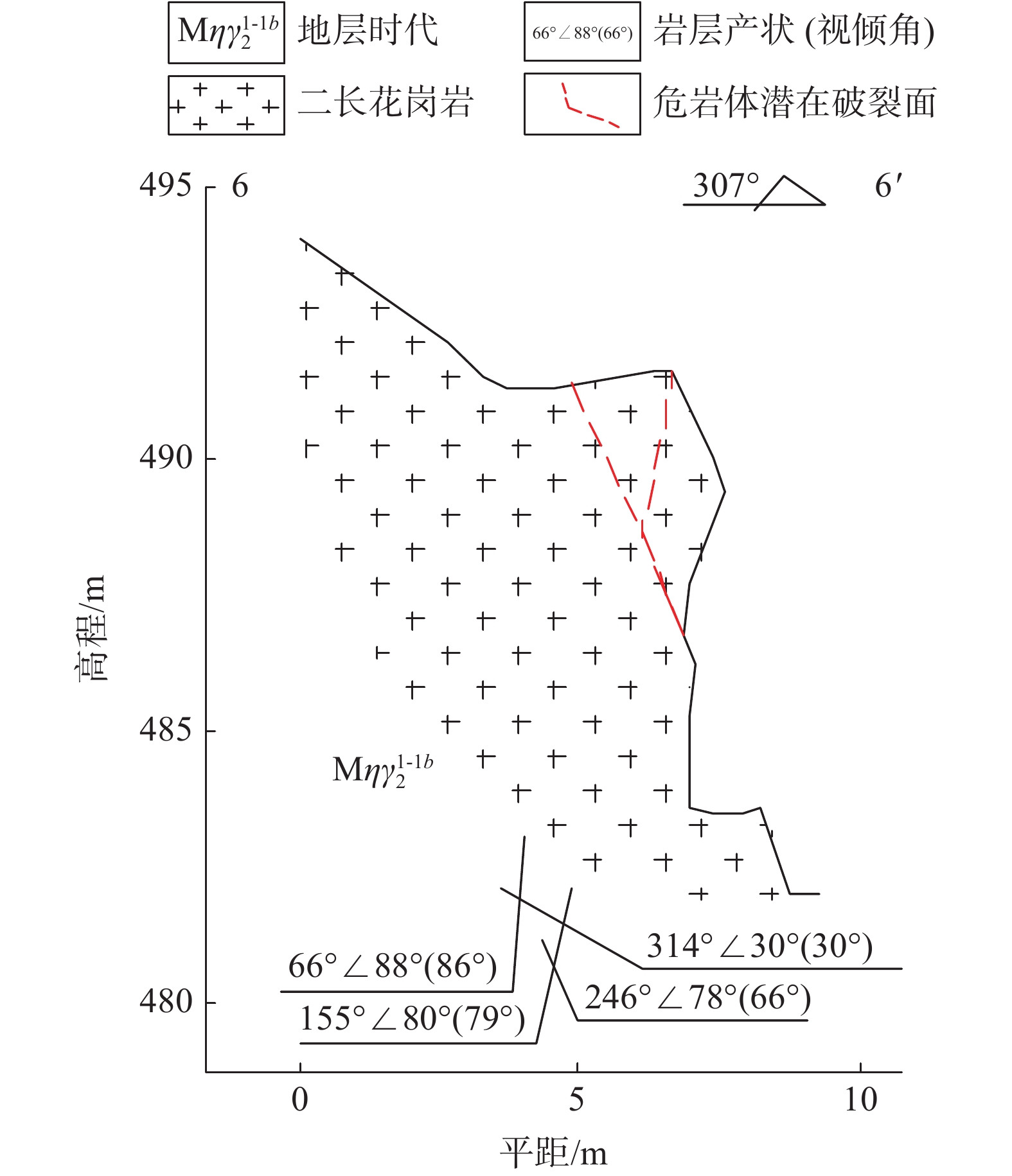
结构面246°∠78° 3.24 0.86 平直 张开 无充填 2号节理面 66°∠88° 2.66 1.72 波状起伏 张开 无充填 3号节理面 314°∠30° 4.56 1.75 平直 张开 充填 4号节理面 155°∠80° 1.32 0.35 波状起伏 闭合 无充填 其中246°∠78°为花岗岩侵入过程中形成的原生结构面,314°∠30°、66°∠88°、155°∠80°这三组节理面与原生节理相互切割形成不利组合。根据其结构面交切组合特征,并结合专利“一种获取危岩体地形剖面的方法”[20],绘制出3、6、8号危岩带中的典型危岩体的大比例尺工程地质剖面图(图6、图7、图8)。
2.3 危岩体稳定性评价
2.3.1 变形破坏影响因素与失稳破坏模式
结合野外现场调查和室内分析,杏花峪隧道进口危岩体的变形破坏模式主要受内因(地形地貌、地层岩性、节理裂隙发育情况)和外因(地震、降雨、风化 作用、人类工程活动的影响)控制。
该斜坡位于玉带河凹岸,受水流长期冲刷作用形成陡坡,黄巢水库修建后河流水流流速减缓,近于平静,冲刷能力减弱;斜坡地层岩性单一,为花岗岩硬岩地层,抗风化能力较强,岩体呈近直立或倒悬状态;由于坡体倾向北西,原生结构面(246°∠78°)倾向南西,且受两组(314°∠30°、155°∠80°)优势构造结构面的切割形成不利块体,岩体易于向北东滑落,最终形成近直立及倒倾危岩体,进而产生倾倒式和坠落式破坏。
2.3.2 危岩体稳定性计算
根据边坡岩体结构特征及危岩体变形破坏模式,采用极限平衡法对边坡危岩体在不同工况组合下的稳定性进行计算,计算结果见表3。
表 3 危岩体稳定性计算结果Table 3. Stability calculation results of rockfall工况危岩编号 天然工况 暴雨工况 地震工况 K 稳定性评价 K 稳定性评价 K 稳定性评价 1号危岩体 1.23 基本稳定 1.19 欠稳定 0.99 不稳定 3号危岩体 1.31 基本稳定 1.22 欠稳定 1.06 欠稳定 4号危岩体 1.15 欠稳定 1.14 欠稳定 0.94 不稳定 5号危岩体 1.24 欠稳定 1.08 欠稳定 0.86 不稳定 6号危岩体 1.23 基本稳定 1.02 欠稳定 0.94 不稳定 7号危岩体 1.61 稳定 1.08 欠稳定 0.73 不稳定 8号危岩体 1.07 欠稳定 0.99 不稳定 0.77 不稳定 危岩体在天然状态下处于稳定−欠稳定状态,在暴雨工况下,处于欠稳定−不稳定状态,在地震、爆破振动等不利工况组合作用下,危岩带的危岩体处于欠稳定−不稳定状态。
3. 危岩落石危险性分区与评价
3.1 数值模拟
3.1.1 建立地质模型
3DEC是一款基于离散单元法作为基本理论以描述离散介质力学行为的计算分析程序,能很好地模拟离散岩体的运动过程,从而获得滑坡、崩塌体的运动路径、运动速度、运动位移。因此,本文采用3DEC数值模拟软件建立了杏花峪隧道进口边坡7处危岩体的三维地质模型(图9)。模型长600 m,宽560 m,高约283 m,根据地质模型设定模型的y方向为重力方向,地质模型x、y方向和z方向底面为约束边界,采用3DEC莫尔—库仑模型开展计算。
![]() 图 9 杏花峪隧道进口危岩带三维地质模型Figure 9. Three-dimensional geological model of rockfall at Xinghuayu tunnel entrance
图 9 杏花峪隧道进口危岩带三维地质模型Figure 9. Three-dimensional geological model of rockfall at Xinghuayu tunnel entrance由于该处危岩带发育主要由4组优势结构面切割(246°∠78°、314°∠30°、66°∠88°、155°∠80°)故对3、5、6、7、8危岩带按照这4组优势结构面进行切割。而1、4号危岩带为松散块体,因此对其进行随机切割。
3.1.2 计算参数的选取
由于杏花峪山体基岩为弱风化花岗岩,3、5、6、7、8危岩带表面多风化为强风化花岗岩,因此考虑其结构面为碎块状强风化花岗岩力学参数;1、4危岩带为花岗岩碎块石,考虑其结构面力学强度为全风化花岗岩,下伏基岩为不可变形的刚体。根据室内的岩土体物理力学试验结果并综合考虑该地区经验值来选取3DEC地质模型的计算参数(表4)。
表 4 模型计算参数统计表Table 4. Model calculation parameter岩土体名称 密度
/(g·cm−3)弹性模量
/MPa剪切模量
/MPa抗拉强度
/MPa内摩擦角
/(°)花岗岩 2.7 58 000 29 000 3.2 65 花岗岩W3
结构面(天然)− − − − 50 花岗岩W3
结构面(暴雨)− − − − 30 花岗岩
碎块石(暴雨)− − − − 20 3.1.3 3DEC数值模拟结果分析
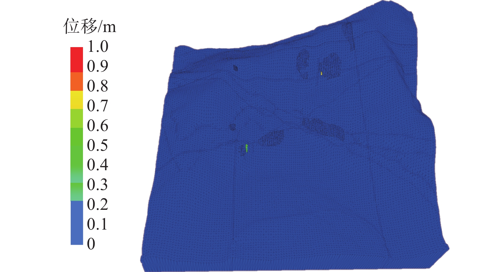
当将杏花峪危岩体天然状态下强风化(W3)的物理力学参数代入模型计算2万步后,模型达到力学平衡状态。由变形量计算结果可知(图10):1、3、4、5、6、7、8号危岩带整体稳定,没有发生整体破坏,只有3号危岩带及7号危岩带出现局部卸荷变形,3号危岩带变形量约0.6 m,7号危岩带变形量为0.75 m。
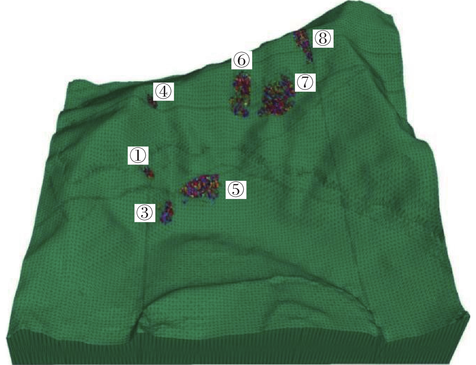
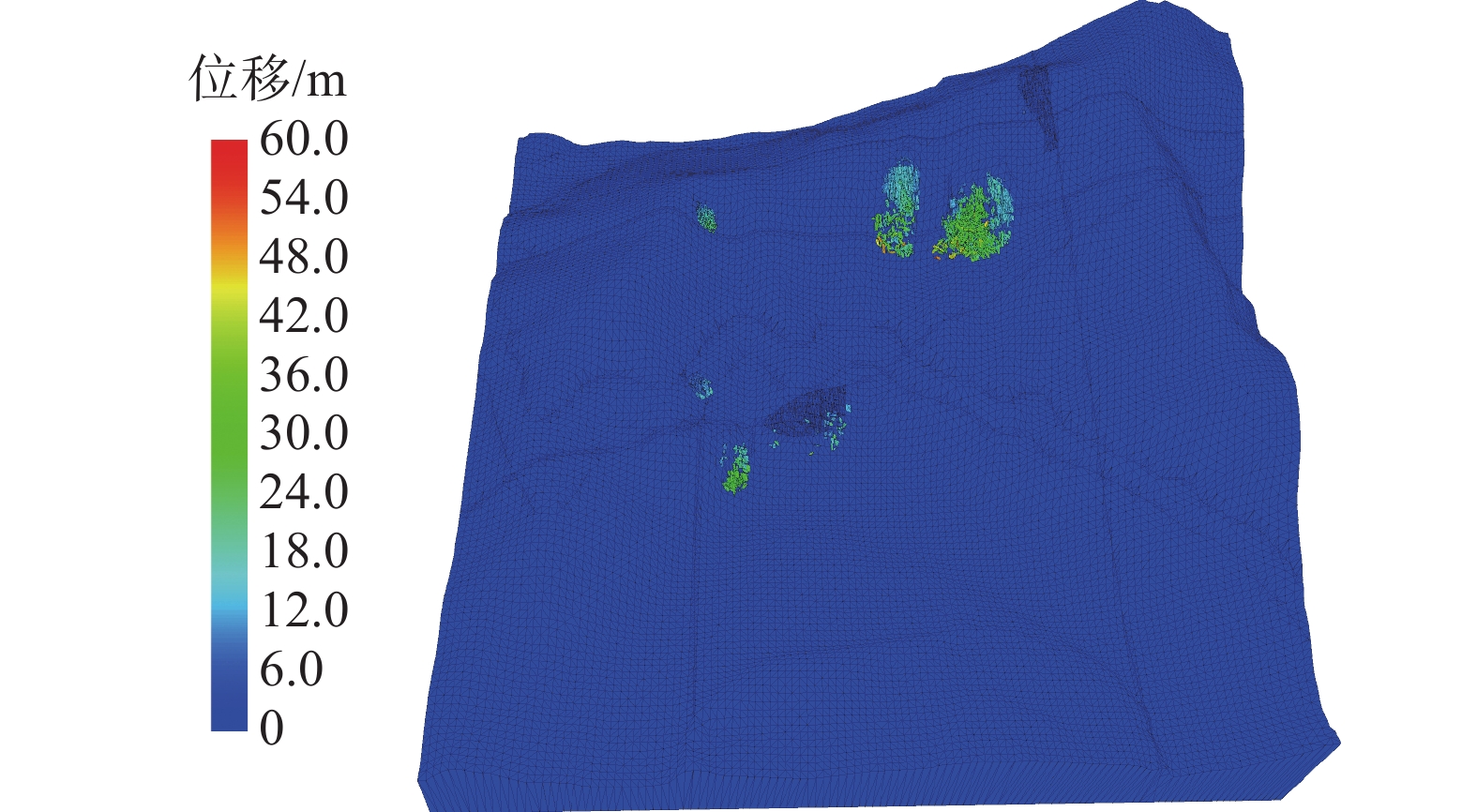
当模型在天然状态下达到力学平衡后,将暴雨状态下的花岗岩物理力学参数代入3、5、6、7、8危岩带,将花岗岩碎块石的物理力学参数代入1、4危岩带。当迭代至48万步时,模型达到力学平衡(图11),1、3、4、6、7号危岩带出现了显著失稳破坏,5、8号危岩带前缘出现了局部失稳破坏,最大滑动位移量为56.5 m(图12)。
![]() 图 11 危岩带暴雨状态下数值模拟计算结果Figure 11. Numerical simulation results of rockfall under rainstorm condition
图 11 危岩带暴雨状态下数值模拟计算结果Figure 11. Numerical simulation results of rockfall under rainstorm condition![]() 图 12 危岩带暴雨状态下的位移量计算结果Figure 12. Displacement calculation results of rockfall under rainstorm condition
图 12 危岩带暴雨状态下的位移量计算结果Figure 12. Displacement calculation results of rockfall under rainstorm condition1号危岩带滑移后散落至坡体中部,最大滑移距离约14 m,最大滑移速率9 m/s。3号危岩带坠落后停积于斜坡坡脚处,最大滑移距离约32 m,最大滑移速率23 m/s。4号危岩带滑移后停积于斜坡冲沟内,最大滑移距离31.5 m,最大滑移速率16 m/s。5号危岩体位于隧道进口处,发生局部崩塌坠落至斜坡下部,对桥隧接口处造成较大威胁,最大滑移距离为42.5 m,最大滑移速率为25 m/s。6号危岩带崩落后停积于下部缓坡及沟槽中,最大滑移距离55.5 m,最大滑移速率34 m/s。7号危岩带崩落后停积于下部缓坡中,最大滑移距离56.5 m,最大滑移速率51 m/s。8号危岩带上部块体出现局部崩落,崩落后停积于斜坡上,最大滑移距离6.5 m,最大滑移速率5 m/s。
综上所述,杏花峪隧道进口危岩体通过数值模拟表明,4、6、7、8号危岩带滑动后岩体不会滑落至杏花峪隧道进口及清水圈大桥桥下。5号危岩带在暴雨条件下会发生局部崩落,对隧道进口及清水圈桥梁桥墩威胁极大需清除坡表及上部松散岩块,避免发生局部崩塌威胁施工及铁路运营安全。
3.2 指标选取及权重计算
通常来说,崩塌落石的危险性主要体现在危岩体自身的稳定程度以及对承载物的破坏能力两个方面。以此选取了危岩体的稳定性、危岩体体积、落石运动速度、落石数量、落石块径及下垫面特征这6个评价指标来对危岩落石的危险性进行分区和评价。参考前人对这6个指标打分标准的划分[21-22],来建立评价指标的打分标准(表5)。
表 5 评价指标打分表及权重值Table 5. Evaluation index score and weight value评价指标(i) 低危险性0~25(S) 中危险性25~50(S) 高危险性50~75(S) 极高危险性75~100(S) 权重值 危岩稳定性 稳定 基本稳定 欠稳定 不稳定 0.402 落石运动速度/(m·s−1) S<0.5 0.5≤S<5 5≤S<15 15≤S 0.235 落石数量/个 0 0≤N<3 3≤N<5 5≤N 0.146 危岩体体积/m3 V≤10 10<V≤100 100<V≤10 000 10 000<V 0.083 落石块径/m <0.1 0.1≤D<0.5 0.5≤D<1 1≤D 0.083 下垫面特征 松散土质,
植被极茂盛较中等密实的土质,
植被较茂盛较密实坚硬的土质,
有植被坚硬岩质,
植被稀少0.051 采用层次分析法(analytic hierarchy process,AHP)[23]对稳定性、危岩体体积、落石运动速度、落石数量、落石块径及下垫面特征这6个评价指标的重要性进行两两比较,并基于AHP法的评价尺度将评价指标之间的权重关系用数值表示出来,建立正互反判断矩阵,归一化后求得6个评价指标的权重:W=(0.402,0.235,0.146,0.083,0.083,0.051)。
为保证判断者评价逻辑的一致性及指标比较次序的一致性,需对判断矩阵进行一致性检验及次序一致性检验。对于判断矩阵的一致性检验,采用和积法近似求得判断矩阵的最大特征根λmax = 6.051,一致性指标C.I.=0.010、6阶判断矩阵的随机一致性指标R.I.=1.240,因此,一致性评价指标C.R.=C.I./R.23.=0.008<0.1,说明此判断矩阵满足一致性检验。
3.3 危险性分区评价
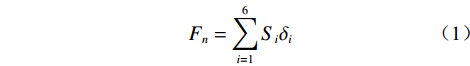
通过3DEC数值模拟,可以获得危岩体失稳破坏后的运动范围、落石运动速度及落石数量,而通过现场地质调绘和无人机三维实景模型可以获得下垫面的岩性及植被发育情况。通过稳定性、危岩体体积、落石运动速度、落石数量、落石块径及下垫面特征这6个指标的打分值可以计算危岩的综合评分值:
$$ {F}_{n}=\sum _{i=1}^{6}{S}_{i}{\delta }_{i} $$ (1) 式中:
$ {F}_{n} $ ——n号危岩的综合评分值;$ {S}_{i} $ ——n号危岩的第i个指标的评分值;$ {\delta }_{i} $ ——n号危岩的第i个指标的权重值。结果得到F1=49.02、F3=63.20、F4=48.42、F5=74.23、F6=70.21、F7=69.12、F8=63.92其综合评分值对应的危险性分区见下表6。
表 6 综合评分值与危险性分区的对应关系Table 6. The corresponding relationship between comprehensive score value and hazard zone危险性分区
及综合
评分值F极高危险区
75<F≤100高危险区
50<F≤75中危险区
25<F≤50低危险区
0<F≤25危岩编号 无 3、5、6、7、8号 1、4号 无 打分结果显示:在3DEC数值模拟结合层次分析法(AHP)进行危险性分区的7处危岩带中,1、4号危岩带影响区域处于中危险区,3、5、6、7、8号危岩带影响区域处于高危险区域。
将3DEC模拟落石运动的计算结果在地形图上圈出,结合危岩落石危险性评分结果,重叠部分按最高危险性原则确定,可获得大小为600 m×560 m的杏花峪隧道进口范围内危岩体的危险性分区云图(图13)。
根据研究区杏花峪隧道进口边坡范围内的危岩落石危险性分区图可知:
中危险区(黄色)主要分布在线路D1K38+188左侧60~77 m处,高程379~396 m,以及线路D1K38+326左侧70~96 m处,高程433~463 m,平面总面积1009.16 m2,占区域总面积的0.30%;
高危险区(橙色)主要分布于线路D1K38+129~153 左侧44~55 m范围内,高程在332~369 m,以及线路D1K38+297~399 m右侧63~208 m处,高程在421~502 m,平面总面积9451.01 m²,占区域总面积的2.81%。
其余为低危险区。在暴雨工况下,隧道进口处于高危险性区域,5号危岩带对隧道进口有较大威胁。
4. 防治措施
根据获取的研究区危岩落石危险性分区云图可知,对杏花峪隧道进口及相邻桥台有影响的为5号危岩带,隧道洞口处于高危险性区域。且隧道洞口上方植被茂密,存在潜在危岩体的可能性较高。
地质灾害的防治工程遵循主动避让、综合防治的原则,根据《崩塌防治工程设计规范(试行)》[24],该防治工程等级属I级。考虑危岩落石威胁工程设施的重要性,受灾损失大,故针对5号危岩带及其上方隐蔽的落石源区,建议采用“被动防护网+接长明洞”对危岩带进行综合防治,并在铁路建设及运营阶段对危岩带进行动态监测,以达到拟建工程对灾害的防治要求。
5. 结论
本文通过现场调查、无人机三维倾斜摄影、数字地质调绘的手段,对济枣线杏花峪隧道进口范围内的危岩带的发育特征、规模、变形破坏模式进行了详细的判识,并基于3DEC数值模拟对危岩落石的运动特征进行了分析,结合层次分析法制作了研究区危岩落石危险性分区云图,针对拟建工程提出了相应的防治对策,主要得到以下结论:
(1)杏花峪隧道进口共识别出12处危岩带,其中7处对铁路隧道进口构成潜在威胁。
(2)1、4号危岩带影响区域处于中危险区,3、5、6、7、8号危岩带影响区域处于高危险区域。
(3)5号危岩带对隧道洞口及桥台安全影响最大,其余危岩带对隧道无影响。
(3)针对影响拟建工程的5号危岩带及其上方隐蔽落石源区,采用“被动防护网+明洞”方式进行综合防治。
-
![]()
图 5 危岩体结构面点密度等值线图(下半球)
Figure 5. Contour map of structural point density(lower hemisphere)
![]()
图 9 杏花峪隧道进口危岩带三维地质模型
Figure 9. Three-dimensional geological model of rockfall at Xinghuayu tunnel entrance
![]()
图 11 危岩带暴雨状态下数值模拟计算结果
Figure 11. Numerical simulation results of rockfall under rainstorm condition
![]()
图 12 危岩带暴雨状态下的位移量计算结果
Figure 12. Displacement calculation results of rockfall under rainstorm condition
表 1 危岩带基本特征
Table 1 Basic characteristics and scale of rockfall
分带编号 危岩体体积/m³ 落石块径/m 相对高度/m 破坏模式 WY-01 12.12 0.2~1.12 44~48 滑移式 WY-03 960 0.4~1.3 0~10 坠落式 WY-04 1.4 0.5 114 滑移式 WY-05 73.2 0.3~1.3 5 坠落式 WY-06 736 0.8~4.3 121~146 倾倒式 WY-07 1 600 0.2~2.2 109~149 倾倒式 WY-08 1 823 0.14~2.12 156~198 倾倒式、滑移式  下载: 导出CSV
表 2 结构面基本特征
Table 2 Basic characteristics of joint surface
结构面编号 产状 延伸长度
/m间距
/m起伏度 张开或
闭合充填情况 1号原生
结构面246°∠78° 3.24 0.86 平直 张开 无充填 2号节理面 66°∠88° 2.66 1.72 波状起伏 张开 无充填 3号节理面 314°∠30° 4.56 1.75 平直 张开 充填 4号节理面 155°∠80° 1.32 0.35 波状起伏 闭合 无充填
下载: 导出CSV
表 3 危岩体稳定性计算结果
Table 3 Stability calculation results of rockfall
工况危岩编号 天然工况 暴雨工况 地震工况 K 稳定性评价 K 稳定性评价 K 稳定性评价 1号危岩体 1.23 基本稳定 1.19 欠稳定 0.99 不稳定 3号危岩体 1.31 基本稳定 1.22 欠稳定 1.06 欠稳定 4号危岩体 1.15 欠稳定 1.14 欠稳定 0.94 不稳定 5号危岩体 1.24 欠稳定 1.08 欠稳定 0.86 不稳定 6号危岩体 1.23 基本稳定 1.02 欠稳定 0.94 不稳定 7号危岩体 1.61 稳定 1.08 欠稳定 0.73 不稳定 8号危岩体 1.07 欠稳定 0.99 不稳定 0.77 不稳定
下载: 导出CSV
表 4 模型计算参数统计表
Table 4 Model calculation parameter
岩土体名称 密度
/(g·cm−3)弹性模量
/MPa剪切模量
/MPa抗拉强度
/MPa内摩擦角
/(°)花岗岩 2.7 58 000 29 000 3.2 65 花岗岩W3
结构面(天然)− − − − 50 花岗岩W3
结构面(暴雨)− − − − 30 花岗岩
碎块石(暴雨)− − − − 20
下载: 导出CSV
表 5 评价指标打分表及权重值
Table 5 Evaluation index score and weight value
评价指标(i) 低危险性0~25(S) 中危险性25~50(S) 高危险性50~75(S) 极高危险性75~100(S) 权重值 危岩稳定性 稳定 基本稳定 欠稳定 不稳定 0.402 落石运动速度/(m·s−1) S<0.5 0.5≤S<5 5≤S<15 15≤S 0.235 落石数量/个 0 0≤N<3 3≤N<5 5≤N 0.146 危岩体体积/m3 V≤10 10<V≤100 100<V≤10 000 10 000<V 0.083 落石块径/m <0.1 0.1≤D<0.5 0.5≤D<1 1≤D 0.083 下垫面特征 松散土质,
植被极茂盛较中等密实的土质,
植被较茂盛较密实坚硬的土质,
有植被坚硬岩质,
植被稀少0.051
下载: 导出CSV
表 6 综合评分值与危险性分区的对应关系
Table 6 The corresponding relationship between comprehensive score value and hazard zone
危险性分区
及综合
评分值F极高危险区
75<F≤100高危险区
50<F≤75中危险区
25<F≤50低危险区
0<F≤25危岩编号 无 3、5、6、7、8号 1、4号 无
下载: 导出CSV
-
[1] 王栋,张广泽,李新坡,等. 川藏铁路折多山隧道进口岩崩运动特征及防治措施[J]. 科学技术与工程,2017,17(34):118 − 123. [WANG Dong,ZHANG Guangze,LI Xinpo,et al. Movement characteristics and prevention of talus slope in Zheduoshan tunnel of Sichuan-Tibet railway[J]. Science Technology and Engineering,2017,17(34):118 − 123. (in Chinese with English abstract) WANG Dong, ZHANG Guangze, LI Xinpo, et al. Movement characteristics and prevention of talus slope in Zheduoshan tunnel of Sichuan-Tibet railway[J]. Science Technology and Engineering, 2017, 17(34): 118-123. (in Chinese with English abstract)][知网中文][知网英文
[2] 王栋,王剑锋,李天斌,等. 西南山区某铁路隧道口高位落石三维运动特征分析[J]. 地质力学学报,2021,27(1):96 − 104. [WANG Dong,WANG Jianfeng,LI Tianbin,et al. Analysis of three-dimensional movement characteristics of rockfall:A case study at a railway tunnel entrance in the southwestern mountainous area,China[J]. Journal of Geomechanics,2021,27(1):96 − 104. (in Chinese with English abstract) WANG Dong, WANG Jianfeng, LI Tianbin, et al. Analysis of three-dimensional movement characteristics of rockfall: a case study at a railway tunnel entrance in the southwestern mountainous area, China[J]. Journal of Geomechanics, 2021, 27(1): 96-104. (in Chinese with English abstract)][知网中文][知网英文
[3] 王玉锁,杨国柱. 隧道洞口段危岩落石风险评估[J]. 现代隧道技术,2010,47(6):33 − 39. [WANG Yusuo,YANG Guozhu. Rockfall risk assessment for a tunnel portal section[J]. Modern Tunnelling Technology,2010,47(6):33 − 39. (in Chinese with English abstract) WANG Yusuo, YANG Guozhu. Rockfall risk assessment for a tunnel portal section[J]. Modern Tunnelling Technology, 2010, 47(6): 33-39. (in Chinese with English abstract)][知网中文][知网英文
[4] 黄海宁,巨能攀,黄健,等. 郑万高铁宜万段边坡危岩崩落破坏特征[J]. 水文地质工程地质,2020,47(3):164 − 172. [HUANG Haining,JU Nengpan,HUANG Jian,et al. Caving failure characteristic of slope rockfall on Yiwan section of the Zhengzhou−Wanzhou high-speed railway[J]. Hydrogeology & Engineering Geology,2020,47(3):164 − 172. (in Chinese with English abstract) HUANG Haining, JU Nengpan, HUANG Jian, et al. Caving failure characteristic of slope rockfall on Yiwan section of the Zhengzhou—Wanzhou high-speed railway[J]. Hydrogeology & Engineering Geology, 2020, 47(3): 164-172. (in Chinese with English abstract)][知网中文][知网英文
[5] HE S M,YAN S X,DENG Y,et al. Impact protection of bridge piers against rockfall[J]. Bulletin of Engineering Geology and the Environment,2019,78(4):2671 − 2680. DOI: 10.1007/s10064-018-1250-5
[6] 董秀军,裴向军,黄润秋. 贵州凯里龙场镇山体崩塌基本特征与成因分析[J]. 中国地质灾害与防治学报,2015,26(3):3 − 9. [DONG Xiujun,PEI Xiangjun,HUANG Runqiu. The Longchangzhen collapse in Kaili,Guizhou:Characteristics and failure causes[J]. The Chinese Journal of Geological Hazard and Control,2015,26(3):3 − 9. (in Chinese with English abstract) DOI: 10.16031/j.cnki.issn.1003-8035.2015.03.02 DONG Xiujun, PEI Xiangjun, HUANG Runqiu. The Longchangzhen collapse in Kaili, Guizhou: characteristics and failure causes[J]. The Chinese Journal of Geological Hazard and Control, 2015, 26(3): 3-9. (in Chinese with English abstract)][知网中文][知网英文 DOI: 10.16031/j.cnki.issn.1003-8035.2015.03.02
[7] Federal Highway Administration of USA. 1993 Rockfall Hazard Rating System: Paricipant’s Manual[M]. FHWA SA-93-057.
[8] JABOYEDOFF M,DUDT J P,LABIOUSE V. An attempt to refine rockfall hazard zoning based on the kinetic energy,frequency and fragmentation degree[J]. Natural Hazards and Earth System Sciences,2005,5(5):621 − 632. DOI: 10.5194/nhess-5-621-2005
[9] HASEGAWA A,URAKOSHI T. Hazard mapping method for rock Falls using a digital elevation model[J]. Quarterly Report of RTRI,2018,59(1):51 − 56. DOI: 10.2219/rtriqr.59.1_51
[10] FANOS A M. A novel rockfall hazard assessment using laser scanning data and 3D modelling in GIS[J]. CATENA,2019,172:435 − 450. DOI: 10.1016/j.catena.2018.09.012
[11] 叶四桥,唐红梅,祝辉. 基于AHP-Fuzzy方法的危岩危险度评价[J]. 武汉理工大学学报(交通科学与工程版),2006,30(5):800 − 803. [YE Siqiao,TANG Hongmei,ZHU Hui. Dangerous degree estimation of perilous rock based on AHP-fuzzy method[J]. Journal of Wuhan University of Technology (Transportation Science & Engineering),2006,30(5):800 − 803. (in Chinese with English abstract) YE Siqiao, TANG Hongmei, ZHU Hui. Dangerous degree estimation of perilous rock based on AHP-fuzzy method[J]. Journal of Wuhan University of Technology (Transportation Science & Engineering), 2006, 30(5): 800-803. (in Chinese with English abstract)][知网中文][知网英文
[12] 叶四桥,陈洪凯. 隧道洞口坡段落石灾害危险性等级评价方法[J]. 中国铁道科学,2010,31(5):59 − 65. [YE Siqiao,CHEN Hongkai. The evaluation method for the hazard grading of the rockfall at the slope segment of the tunnel entrance[J]. China Railway Science,2010,31(5):59 − 65. (in Chinese with English abstract) YE Siqiao, CHEN Hongkai. The evaluation method for the hazard grading of the rockfall at the slope segment of the tunnel entrance[J]. China Railway Science, 2010, 31(5): 59-65. (in Chinese with English abstract)][知网中文][知网英文
[13] 唐红梅,韩明明,闫凝. 基于GIS的重庆巫山县崩塌灾害危险性分区评价[J]. 重庆师范大学学报(自然科学版),2019,36(5):72 − 79. [TANG Hongmei,HAN Mingming,YAN Ning. The GIS-based danger zoning evaluation of collapse disaster in Wushan County,Chongqing[J]. Journal of Chongqing Normal University (Natural Science),2019,36(5):72 − 79. (in Chinese with English abstract) TANG Hongmei, HAN Mingming, YAN Ning. The GIS-based danger zoning evaluation of collapse disaster in Wushan County, Chongqing[J]. Journal of Chongqing Normal University (Natural Science), 2019, 36(5): 72-79. (in Chinese with English abstract)][知网中文][知网英文
[14] 唐红梅,韩明明,王林峰. 基于AHP-Fuzzy法的灰岩地区崩塌体失稳危险性评价[J]. 灾害学,2019,34(3):1 − 7. [TANG Hongmei,HAN Mingming,WANG Linfeng. Hazard assessment of collapsed rock mass in limestone area based on AHP-fuzzy method[J]. Journal of Catastrophology,2019,34(3):1 − 7. (in Chinese with English abstract) TANG Hongmei, HAN Mingming, WANG Linfeng. Hazard assessment of collapsed rock mass in limestone area based on AHP-fuzzy method[J]. Journal of Catastrophology, 2019, 34(3): 1-7. (in Chinese with English abstract)][知网中文][知网英文
[15] 高买燕,唐红梅,曾云松,等. 崩塌灾害危险性评价方法及应用[J]. 重庆交通大学学报(自然科学版),2013,32(3):446 − 450. [GAO Maiyan,TANG Hongmei,ZENG Yunsong,et al. Rockfall hazard assessment method and its application[J]. Journal of Chongqing Jiaotong University (Natural Science),2013,32(3):446 − 450. (in Chinese with English abstract) GAO Maiyan, TANG Hongmei, ZENG Yunsong, et al. Rockfall hazard assessment method and its application[J]. Journal of Chongqing Jiaotong University (Natural Science), 2013, 32(3): 446-450. (in Chinese with English abstract)][知网中文][知网英文
[16] 巩尚卿,叶四桥,杨威. 落石灾害危险性概率评价方法[J]. 灾害学,2014,29(4):215 − 219. [GONG Shangqing,YE Siqiao,YANG Wei. Evaluation method for probability of rockfall hazard[J]. Journal of Catastrophology,2014,29(4):215 − 219. (in Chinese with English abstract) GONG Shangqing, YE Siqiao, YANG Wei. Evaluation method for probability of rockfall hazard[J]. Journal of Catastrophology, 2014, 29(4): 215-219. (in Chinese with English abstract)][知网中文][知网英文
[17] 武中鹏,刘宏,董秀群,等. 单体危岩崩塌灾害危险性评价—以贵州威宁县新发乡樊家岩为例[J]. 中国地质灾害与防治学报,2019,30(2):30 − 34. [WU Zhongpeng,LIU Hong,DONG Xiuqun,et al. Hazard assessment of rockfall disaster of a dangerous rock:A case study at Fanjiayan,Xinfa Township,Weining County of Guizhou Province[J]. The Chinese Journal of Geological Hazard and Control,2019,30(2):30 − 34. (in Chinese with English abstract) WU Zhongpeng, LIU Hong, DONG Xiuqun, et al. Hazard assessment of rockfall disaster of a dangerous rock: a case study at Fanjiayan, Xinfa Township, Weining County of Guizhou Province[J]. The Chinese Journal of Geological Hazard and Control, 2019, 30(2): 30-34. (in Chinese with English abstract)][知网中文][知网英文
[18] 王栋,邹杨,张广泽,等. 无人机技术在超高位危岩勘查中的应用[J]. 成都理工大学学报(自然科学版),2018,45(6):754 − 759. [WANG Dong,ZOU Yang,ZHANG Guangze,et al. Application of photographic technique by unmanned aerial vehicle to dangerous rock exploration[J]. Journal of Chengdu University of Technology (Science & Technology Edition),2018,45(6):754 − 759. (in Chinese with English abstract) WANG Dong, ZOU Yang, ZHANG Guangze, et al. Application of photographic technique by unmanned aerial vehicle to dangerous rock exploration[J]. Journal of Chengdu University of Technology (Science & Technology Edition), 2018, 45(6): 754-759. (in Chinese with English abstract)][知网中文][知网英文
[19] 李嘉雨,李欣,樊金,等. Ⅰ类轻型无人机在铁路地质勘察中的应用与展望[J]. 铁道勘察,2020,46(4):28 − 31. [LI Jiayu,LI Xin,FAN Jin,et al. The application and prospect of type Ⅰ light unmanned aerial vehicle in railway geological survey[J]. Railway Investigation and Surveying,2020,46(4):28 − 31. (in Chinese with English abstract) LI Jiayu, LI Xin, FAN Jin, et al. The application and prospect of type Ⅰ light unmanned aerial vehicle in railway geological survey[J]. Railway Investigation and Surveying, 2020, 46(4): 28-31. (in Chinese with English abstract)][知网中文][知网英文
[20] 李嘉雨, 张广泽, 陈明浩, 等. 一种获取危岩体地形剖面的方法: CN113946982A[P]. 2022-01-18 LI Jiayu, ZHANG Guangze, CHEN Minghao, et al. Method for acquiring dangerous rock body terrain profile: CN113946982A[P]. 2022-01-18. (in Chinese)
[21] 李嘉雨,王崇艮,毛邦燕,等. 基于滑距计算与危险性评价的某平推式滑坡防治对策研究[J]. 长江科学院院报,2021,38(4):63 − 69. [LI Jiayu,WANG Chonggen,MAO Bangyan,et al. Prevention and control countermeasures of translational landslide based on sliding distance calculation and hazard evaluation[J]. Journal of Yangtze River Scientific Research Institute,2021,38(4):63 − 69. (in Chinese with English abstract) LI Jiayu, WANG Chonggen, MAO Bangyan, et al. Prevention and control countermeasures of translational landslide based on sliding distance calculation and hazard evaluation[J]. Journal of Yangtze River Scientific Research Institute, 2021, 38(4): 63-69. (in Chinese with English abstract)][知网中文][知网英文
[22] 李嘉雨,毛邦燕,陈亮,等. 基于3DEC模拟的既有铁路单体滑坡危险性分区与评价—以川黔线裁缝岩滑坡为例[J]. 铁道勘察,2019,45(1):40 − 46. [LI Jiayu,MAO Bangyan,CHEN Liang,et al. The hazard division and evaluation of single landslide based on 3 dimension distinct element simulation of the existing Chuan-Qian railway[J]. Railway Investigation and Surveying,2019,45(1):40 − 46. (in Chinese with English abstract) LI Jiayu, MAO Bangyan, CHEN Liang, et al. The hazard division and evaluation of single landslide based on 3 dimension distinct element simulation of the existing Chuan-Qian railway[J]. Railway Investigation and Surveying, 2019, 45(1): 40-46. (in Chinese with English abstract)][知网中文][知网英文
[23] SAATY T L. The analytic hierarchy process[M]. New York: McGraw-Hill, 1980: 35 − 40.
[24] 中国地质灾害防治工程行业协会. 崩塌防治工程设计规范: T/CAGHP032—2018[S]. 武汉: 中国地质大学出版社, 2018 China Association of Geological Hazard Prevention. Code for design of rock fall control engineering: T/CAGPH032-2018[S]. Wuhan: China University of Geosciences Press, 2018. (in Chinese)
-
期刊类型引用(4)
1. 刘美琳,邓睿,李嘉雨,丁浩江,刘芝勇,刘毅. 基于无人机和Rocfall的危岩落石特征分析与运动学模拟研究——以圆宝山隧道出口为例. 铁道技术标准(中英文). 2024(01): 36-44 .  百度学术
百度学术
2. 陈宇,沈位刚,宋忠友,高攀,鄢发斌,雍平,张锐. 土垫层缓冲落石冲击力特性离散元数值模拟分析. 中国地质灾害与防治学报. 2024(02): 90-97 . 本站查看
3. 李松岩,李嘉雨,张可,陈亮,罗文豪. 大巴山峡谷区高陡危岩发育特征与风险评价. 路基工程. 2024(04): 34-41 . 百度学术
4. 苏国韶,甘衍垦,刘友能,王钧沐. 危岩稳定性分析的三维离散元超载法与强度折减法对比研究. 山西建筑. 2024(24): 1-5 . 百度学术
其他类型引用(1)


计量
- 文章访问数: 1649
- HTML全文浏览量: 525
- PDF下载量: 257
- 被引次数: 5
 邮件订阅
邮件订阅 RSS
RSS