

Preliminary analysis on basic characteristics and mechanism of rockfalls in layered red rocks with gentle dip angle: A case study of the Tiejiangwan rockfall in Hongya County, Sichuan Province
-
摘要: 红层区常发育缓倾角岩质边坡,因其软硬相间的岩性组合,地质灾害频发,灾害严重。基于光学卫星遥感、无人机航空摄影测量、现场调查等天空地一体化的技术手段,以2021年4月5日发生的四川洪雅铁匠湾缓倾角红层岩质崩塌为研究对象,探讨了崩塌的基本特征和成因机理,分析了铁匠湾陡崖区崩塌灾害发展趋势,以期为红层区类似灾害的研究提供资料支撑。结果表明:铁匠湾崩塌可分为主崩塌区和崩塌影响区两个区域,其中主崩塌区包括崩源区1处、铲刮区1处、堆积区1处、流水二次搬运堆积区1处,崩塌影响区包括潜在崩源区1处、扰动变形区5处。崩塌源区具有“上硬下软”的岩石组合,岩体发育两组近于垂直的优势结构面,2013年已表现出变形迹象,在降雨、温差的持续作用下导致源区危岩体的最终失稳垮塌,巨大的冲击力作用于危岩体下方的老崩塌堆积体和基岩,引起崩塌-碎屑流灾害链。在光学遥感影像解译和野外调查的基础上,认为铁匠湾崩塌存在二次崩塌的风险,在崩塌邻区识别出类似崩塌隐患点6处,建议采用无人机、机载LiDAR等技术手段开展铁匠湾陡崖区崩塌隐患的早期识别与持续监测。Abstract: Gentle dip angle rock slopes are often developed in layered red rocks, which are prone to geological disasters due to the combination of soft and hard lithology. This paper discusses the Tiejiangwan rockfall that occurred on April 5, 2021, in Hongya County of Sichuan province, China, on a layered red rocks slope with a gentle dip angle. Using an air-space-ground integrated earth observation network, including optical remote sensing, UAV aerial photogrammetry, and on-site investigation, the study analyzes the basic characteristics and mechanism of rockfall and predicts the development trend of similar disasters in the steep cliff area of layered red rocks. The results show that the Tiejiangwan rockfall can be divided into two areas, namely the main rockfall area and the rockfall influence area. The main rockfall area comprises one rockfall source area, one shoveling area, one accumulation area, and one water secondary transportation accumulation area. The rockfall influence area includes one potential rockfall source area and five disturbance deformation areas. The rockfall source area has a combination of hard rocks at the top and soft rocks at the bottom, and the rock mass develops two groups of nearly vertical dominant structural planes. In 2013, the source area showed signs of deformation, which eventually lead to the instability of the dangerous rock mass due to the continuous effect of rainfall and temperature differences. The huge impact force caused the rockfall debris flow disaster chain, affecting the old rockfall accumulation body and bedrock under the dangerous rock mass. Optical remote sensing images and field investigation indicate the risk of secondary collapse in Tiejiangwan rockfall. Additionally, six similar potential rockfalls were identified in the adjacent area. To prevent similar disasters, it is recommended to use UAV aerial photogrammetry and airborne LiDAR for early identification and continuous monitoring of potential rockfalls in the steep cliff area of the Tiejianwan. The findings of this study provide valuable data support for the study of similar disasters in layered red rocks.
-
Keywords:
- rockfall /
- zoning characteristics /
- genetic mechanism /
- gentle dip angle /
- layered red rocks
-
0. 引言
地质灾害易发性评价是以地质环境条件为基础,参考地质灾害现状的静态因素来预测一定区域内发生地质灾害的可能性 [1]。地质灾害易发性评价方法分为定性和定量两类。定性方法主要包括专家评分 [2]、层次分析 [3]等。随着数据获取的便利、计算能力的提升以及评估模型的日趋完善,定量评价方法应用更为广泛,定量方法主要有信息量 [4]、确定性系数 [5]、证据权 [6]、逻辑回归 [7]、支持向量机 [8]、决策树 [9]、随机森林 [10]、神经网络 [11]等。其中确定性系数方法计算严密,可以解决多源数据类型的合并问题和影响因子内部不同特征区间对地质灾害易发性的影响 [12],但单一的确定性系数评价法没有考虑每个评价因素对地质灾害易发性的影响差异。逻辑回归( Logistic Regression,LR) 可以使用简单的线性回归来描述自然现象之间的复杂非线性关系,并根据影响因素与历史灾害点之间的关系确定影响因素的权重。文章基于地理信息系统,将研究区划分为栅格,选取海拔、坡度、坡向、地形曲率、归一化植被指数(Normalized Difference Vegetation Index,NDVI)、工程地质岩组、断层、道路、水系这9个孕灾、诱灾因素作为评价指标因子,采用频率比法(Frequency Ratio,FR)、确定性系数法(Certainty Factor,CF)量化评价指标因子,基于确定性系数法进行逻辑回归运算,计算研究区网格地质灾害发生的概率,得到地质灾害易发性分区图。
1. 研究方法
1.1 频率比(FR)
频率比是建立在假设地质条件、孕育地质灾害的概率相似的地区。频率比重点考虑因子类别与地质灾害发生可能性的空间相关性,定量表示环境因子各属性区间对地质灾害发生的相对影响程度 [13-15],计算方法如式(1)。
(1) 式中:FRi——频率比值;
li——某个评价因子i类属性区间发生地质灾害的 个数;
L——研究区内的总数;
si——某个评价因子i类区间的面积;
S——研究区总面积。
FRi大于 1 表明该环境因子属性区间利于地质灾害发育,值越大表示对地质灾害发育的贡献也越大;反之,FRi小于 1 表明该环境因子属性区间不利于地质灾害发育。
1.2 确定性系数模型(CF)
确定性系数模型假设将来发生地质灾害的条件和过去发生地质灾害的条件相同。CF 计算公式为:
(2) 式中:CF——地质灾害发生的确定性系数;
PPa——地质灾害在因子分类数据a中发生的条件 概率,研究中通常用因子分类a中的地质 灾害个数与因子分类a的面积比值表示;
PPS——地质灾害在整个研究区中发生的先验概率, 以研究区地质灾害总个数与研究区总面 积比值表示。
由式(2)可知,CF的变化区间为[−1,1]。正值表示地质灾害发生的确定性大,越接近1越易于发生地质灾害;负值表示地质灾害发生确定性小,越接近−1越不易于发生地质灾害;值为 0 时表示条件概率和先验概率相同,不确定是否会发生地质灾害 [5]。
1.3 基于确定性系数的逻辑回归模型(CF-LR)
逻辑回归模型是研究二分类因变量常用的多元统计分析方法。自变量Xi 为控制灾害发生的影响因子。因变量Y属于二分类变量,通常 0 代表地质灾害不存在,1 代表地质灾害存在。用线性回归来描述自然现象之间复杂的非线性关系,揭示因变量和多个自变量之间的多元回归关系,将每个评价因子视为自变量,能很好解决滑坡易发性评价中出现的二分类变量问题 [16],逻辑回归函数如式(3):
(3) 式中:P——地质灾害发生的概率;
Z——地质灾害发生概率的目标函数,表达为各因素自变量x1,x2,x3
β0——常数表示在不受任何有利或不利于地质灾害发生因素影响的条件下,地质灾害发生与不发生概率之比的对数值 [17]。
通过确定性系数模型计算得到各评价因子类别的值,将其结果作为逻辑回归模型中的自变量,建立回归方程,进行逻辑回归运算,得到各评价因子的逻辑回归系数,以此进行确定性系数–逻辑回归模型(CF-LR)进行地质灾害易发性评价。
2. 实例分析
2.1 研究区概况
研究区沿河土家族自治县位于贵州省东北部,隶属铜仁市,南北长98.28 km,东西宽53 km,行政区域总面积2483.51km2,占贵州省总面积的1.4%,占铜仁市总面积的13.7%。沿河县境内有乌江及其支流洪渡河、暗溪河、白泥河、坝坨河等26条河流,河道长548.7 km,河网密度0.23 km/km2。地貌轮廓明显受地质构造控制,全县地貌“轴部成山,翼部成谷”。区内出露地层从老到新有震旦系、寒武系、奥陶系、志留系、二叠系、三叠系及第四系。受乌江切割和地层、岩性、构造的影响,在内外营力综合作用下,形成山峦叠障、沟谷纵横、复杂多样的地形地貌景观。区内历史地质灾害以滑坡、崩塌为主,共计130处,滑坡、崩塌分别占全县地质灾害的55.38%、33.85%。研究区地理位置及地质灾害分布如图1所示。
![]() 图 1 研究区地理位置及地质灾害点分布Figure 1. Geographical location and distribution of geological hazard in the study area
图 1 研究区地理位置及地质灾害点分布Figure 1. Geographical location and distribution of geological hazard in the study area2.2 评价指标因子选取
结合研究区的地质背景、地质灾害形成条件及发育特征,初步选取海拔、坡度、坡向、地形曲率、归一化植被指数(NDVI)、工程地质岩组、距断层距离、距道路距离、距水系距离9个影响因素作为评价指标因子。数据源为沿河县地质灾害数据库、地理空间数据云平台获取研究区30 m×30 m数字高程模型(Digital Elevation Model,DEM)、1∶50 000的地质图、Google影像地图,利用ArcGIS平台通过DEM数据提取分析得到研究区坡度、坡向、地形曲率、河流网评价因子图层,通过Google影像地图矢量化得到道路数据,利用 landsat8 影像获得该区的归一化植被指数(NDVI)专题图。
2.3 评价因子相关性分析
影响地质灾害发育的因素之间存在一定的关联,当评价因子之间存在多重共线问题时,会降低模型的预测精度,因而需对评价因素进行相关性分析。利用ArcGIS计算相关矩阵如表1所示,相关性系数绝对值最大为0.324,说明本文选取的9个评价指标因子之间相关性较弱,均可纳入研究区评价模型 [18]。
表 1 评价指标因子相关性系数矩阵Table 1. Correlation coefficient matrix of evaluation index factors评价因子 海拔 坡度 坡向 地形曲率 NDVI 工程地质岩组 断层缓冲区 道路缓冲区 河流缓冲区 海拔 1 坡度 −0.009 1 坡向 0.009 0.059 1 地形曲率 0.138 0.045 −0.004 1 NDVI 0.154 0.094 −0.073 0.032 1 工程地质岩组 −0.004 0.004 −0.016 −0.010 −0.006 1 断层缓冲区 0.182 −0.002 0.002 0.004 0.024 0.104 1 道路缓冲区 0.113 0.081 0.004 0.009 0.043 0.007 0.060 1 河流缓冲区 0.324 −0.042 0.006 0.024 0.059 0.075 0.094 0.146 1 2.4 评价指标因子分析
工程地质岩组为离散型因子,根据野外地质调查以及已有分类标准进行分类,连续型指标因子分类根据地质灾害比例进行等距离划分,各指标因子分级如图2所示,利用式(1)进行频率比计算确定性系数计算,利用式(2)进行确定性系数计算,结果见表2。
表 2 评价指标因子分级、频率比、确定性系数Table 2. Evaluation index factor classification, frequency ratio and certainty coefficient评价指
标因子分级 地质灾
害频数分级面积
/km2频率比 CF 评价指
标因子分级 地质灾
害频数分级面积
/km2频率比 CF 工程地
质岩组坚硬岩组 19 908.650 0.399 −0.374 地形
曲率<−0.2 54 842.320 1.225 0.194 较坚硬岩组 12 433.841 0.528 −0.485 −0.2~0.2 41 804.509 0.974 −0.028 较软岩组 24 354.624 1.293 0.239 ≥0.2 35 836.681 0.799 −0.210 软岩组 24 156.908 2.922 0.694 道路缓
冲区/m0~200 10 121.608 1.571 0.384 软硬相间岩组 51 629.487 1.548 0.373 200~400 7 110.030 1.215 0.187 海拔/m 209~400 19 125.528 2.892 0.690 400~600 8 102.096 1.497 0.350 400~600 35 630.016 1.061 0.061 600~800 8 96.148 1.590 0.391 600~800 46 781.436 1.125 0.117 800~1000 4 91.358 0.836 −0.206 800~1000 23 557.591 0.788 −0.221 ≥1000 93 1962.270 0.905 −0.099 1000~1200 5 329.869 0.290 −0.721 河流缓
冲区/m0~200 18 292.050 1.177 0.159 1200~1408 2 59.068 0.647 −0.366 200~400 20 270.762 1.411 0.307 坡度/(°) 0~8 8 360.777 0.424 −0.589 400~600 16 276.547 1.105 0.112 8~16 44 774.534 1.085 0.083 600~800 15 263.664 1.087 0.084 16~24 47 726.415 1.236 0.202 800~1000 13 249.447 0.996 −0.005 24~32 24 407.503 1.125 0.117 ≥1000 48 1131.039 0.811 −0.198 32~40 5 150.886 0.633 −0.380 断层缓
冲区/m0~300 15 263.922 1.086 0.083 ≥40 2 63.395 0.603 −0.410 300~600 13 246.968 1.006 0.006 坡向 平面 0 9.052 0.000 −1.000 600~900 13 230.345 1.078 0.077 北 17 249.994 1.299 0.243 900~1200 10 202.012 0.946 −0.057 东北 19 325.920 1.114 0.108 1200~1500 8 176.901 0.864 −0.143 东 32 390.819 1.564 0.381 ≥1500 71 1363.363 0.995 −0.005 东南 14 338.893 0.789 −0.220 NDVI −0.02~0.1 9 219.331 0.784 −0.225 南 9 253.127 0.679 −0.333 0.1~0.2 25 459.478 1.039 0.040 西南 21 287.807 1.394 0.298 0.2~0.3 61 1008.861 1.155 0.142 西 7 326.164 0.410 −0.603 0.3~0.4 34 757.656 0.857 −0.149 西北 11 301.734 0.696 −0.315 0.4~0.54 1 38.183 0.500 −0.513 海拔高度与降雨量、植被类型、植被覆盖等有着密切的关系,影响着人类工程活动程度,因此海拔间接影响着地质灾害的发育 [19],海拔高度209~1408 m,将其分为6个类别。
坡度定量描述地面的倾斜程度,它的大小对斜坡表面径流量、斜坡表体土层剩余下滑力等都影响巨大,一定程度上影响着地质灾害发育的规模与强度 [20],研究区坡度最高达75°,以8°等间距分为5类,大于40°为1类,共计6个类别。
不同坡向与岩体结构面的组合关系差异导致地质灾害发育的程度不同 [21],将研究区坡向分为9个类别。
地形曲率是局部地形曲面在各个截面方向上形状、凹凸变化的反映,其值为正时表明边坡是凸面坡,为 0 时表明为平面坡,为负时表明边坡为凹面坡 [22],由于研究区平面坡(曲率等于0)面积极小,所以用曲率为−0.2~0.2代表近似平面坡,将其分为凹坡(<−0.2),近似平面坡(−0.2~0.2),凸坡(≥0.2)3类。
归一化植被指数(NDVI)是遥感影像中近红外波段(NIR)的反射值和红光波段(R)的反射值的差与两者之和的比值,NDVI值的范围为 [−1 , 1],负值表示对可见光高反射,地面为江、河、湖泊等水体或有雪覆盖,0表示NIR和R近似相等,为岩石或裸地等,正值表示有植被覆盖,数值越大表示植被覆盖率越高 [23],研究区NDVI在−0.02~0.54之间,将其分为5个类别。
岩土体是地质灾害发生的物质来源基础,岩石类型、坚硬程度决定岩土体的力学强度、抗风化能力和抗侵蚀能力 [19],研究区工程地质岩组分为5类,分别为坚硬岩组、较坚硬岩组、较软岩组、软岩组和软硬相间岩组。
地质构造影响着岩体结构及其组合特征,对山区地质灾害发育起着重要的控制作用 [24],利用ArcGIS领域分析功能将研究区断层以300 m等距离提取缓冲区,得到6个类别。
道路修建开挖坡体改变原有地质环境,破坏岩土体结构 [25],以200 m等距离提取道路缓冲区,得到6个类别。
河流的侵蚀、侧蚀作用影响地质灾害的发育、且河流是控制坡面侵蚀的重要原因 [26],将研究区河流200 m等距离提取缓冲区,得到6个类别。
通过对因子类别进行分类后,利用式(1)对各评价因子类别进行频率比计算,当频率比大于1时,说明该因子类别对地质灾害发育具有促进作用,如表3所示。
表 3 频率比大于1的属性区间Table 3. Attribute intervals with frequency ratio greater than 1评价因子 海拔/m 坡度/(°) 坡向 地形曲率 NDVI 工程地质岩组 断层缓冲区/m 道路缓冲区/m 河流缓冲区/m 频率比大于
1类别209~400 8~16 北 < −0.2 0.1~0.2 较软质岩 0~300 0~200 0~200 400~600 16~24 东北 0.2~0.3 软质岩 300~600 200~400 200~400 600~800 24~32 东 软硬相间质岩 600~900 400~600 400~600 西南 600~800 600~800 2.5 逻辑回归分析
利用ArcGIS以500 m距离制作灾点缓冲区,在500 m以外提取随机点130个非地质灾害点,与灾害训练样本组成训练集共计260个点。将9个评价指标因子的属性提取至训练集样本,导出后替换成评价因子的CF值导入SPSS软件中进行逻辑回归运算,各评价因子分类级别的CF值作为自变量,是否发生滑坡灾害作为因变量(0 表示未发生地质灾害,1值表示已发生地质灾害),LR-CF模型的逻辑回归运算结果如表4所示,其计算得到的所有评价指标因子的逻辑回归系数均为正数,表明所有评价指标因子对模型均起正向作用。在逻辑回归计算过程中,显著性sig ≤ 0. 05 则该回归系数有效,评价指标因子具有统计意义 [22]。
表 4 逻辑回归系数和显著性Table 4. Logistic regression coefficient and significance评价因子 海拔 坡度 坡向 地形曲率 NDVI 工程地质岩组 断层缓冲区 道路缓冲区 河流缓冲区 常量 β 3.844 2.495 3.418 4.085 1.198 4.377 3.218 0.734 2.728 2.604 sig 0.000 0.003 0.000 0.019 0.023 0.000 0.027 0.036 0.130 0.000 3. 易发性分区与评价
3.1 CF、CF-LR分区结果
基于GIS平台,将评价指标因子图层自定义添加属性字段,对应输入计算的确定性系数,利用栅格叠加得到确定性系数模型评价图,利用自然断点法将沿河县地质灾害易发性区划为低易发区、中易发区、高易发区、极高易发区,其面积(频率比)分别为361.265 km2(0.159)、784.269 km2(0.414)、895.197 km2(1.003)、442.779 km2(2.718),如图3(a)和表5所示。利用栅格计算器按照公式(3)计算得到CF-LR模型地质灾害发生概率图,利用自然断点法将其分为低易发区、中易发区、高易发区、极高易发区,其面积(频率比)分别为671.252 km2(0.142)、467.758 km2(0.327)、927.527 km2(0.741)、507.145 km2(3.051),如图3(b)和表5所示。CF模型和CF-LR模型地质灾害易发性等级的频率比值均从极低易发区到极高易发区明显增大,表明有效评价了研究区地质灾害易发性。CF模型和CF-LR模型计算的极高易发区频率比值分别占总频率比值为63.3%和71.6%。说明CF-LR模型比单一CF模型评价精度更高。
表 5 地质灾害易发性评价频率比值Table 5. Frequency ratio of geological hazard susceptibility evaluation评价模型 易发性
等级分级面积
/km2面积
占比灾害点
频数灾害
占比频率比 CF 低易发区 361.265 0.145 3 0.023 0.159 中易发区 784.269 0.316 17 0.131 0.414 高易发区 895.197 0.360 47 0.362 1.003 极高易发区 442.779 0.178 63 0.485 2.718 CF-LR 低易发区 671.252 0.270 5 0.038 0.142 中易发区 467.758 0.188 8 0.062 0.327 高易发区 927.527 0.373 36 0.277 0.741 极高易发区 507.145 0.204 81 0.623 3.051 3.2 精度验证
本文使用ROC曲线来表示拟合数据和实测数据之间的关系,评价成功率或有效性以AUC值来表示(图4)。曲线中纵轴为敏感度,即实际地质灾害数量百分比累加量,横轴为特异性,即易发性面积百分比累积量,ROC曲线下面积AUC值越大表明模型评估效果越好 [27-28]。CF模型和CF-LR模型AUC值分别为0.722和0.818,说明CF和CF-LR评价模型均能够较为客观准确地对沿河县地质灾害易发性进行评价,且CF法进行逻辑回归后的CF-LR模型评价精度更高。
4. 结论
(1)文中从选取的9个地质灾害影响因素的各类别的频率比值可以看出,在海拔209~800 m,坡度8°~32°,坡向朝向北、东北、东、西南,地形曲率小于−0.2,NDVI为0.1~0.3,较软质岩、软质岩、软硬相间质岩,距断层900 m、道路和河流800 m以内对沿河县地质灾害发育具有促进作用。
(2)CF模型评价低易发区、中易发区、高易发区、极高易发区,其面积(频率比)分别为361.265 km2(0.159)、784.269 km2(0.414)、895.197 km2(1.003)、442.779 km2(2.718);CF-LR模型评价低易发区、中易发区、高易发区、极高易发区,其面积(频率比)分别为671.252 km2(0.142)、467.758 km2(0.327)、927.527 km2(0.741)、507.145 km2(3.051)。CF模型和CF-LR模型地质灾害易发性等级的频率比值从极低易发区到极高易发区明显增大,均有效评价了研究区地质灾害易发性。CF模型和CF-LR模型计算的极高易发区频率比值分别占总频率比值为63.3%和71.6%。
(3)CF模型和CF-LR模型AUC值分别为0.722和0.818,均能够较为客观准确地对沿河县地质灾害易发性进行评价。但单一CF法没有考虑评价因素对地质灾害易发性的影响差异,在此基础上,LR法用线性回归来表示评价因子之间复杂非线性关系,考虑了评价因子的权重,使得AUC值提高了0.096,CF-LR模型具有更高的评价精度。
由于研究区的地质灾害研究样本偏少,不为理想研究实验区,将影响评价效果和精度,对地质灾害易发性评价的精度还需进一步探索。
-
![]()
图 2 铁匠湾崩塌分区特征及野外照片
Figure 2. Subarea features and field photos of the Tiejiangwan rockfall
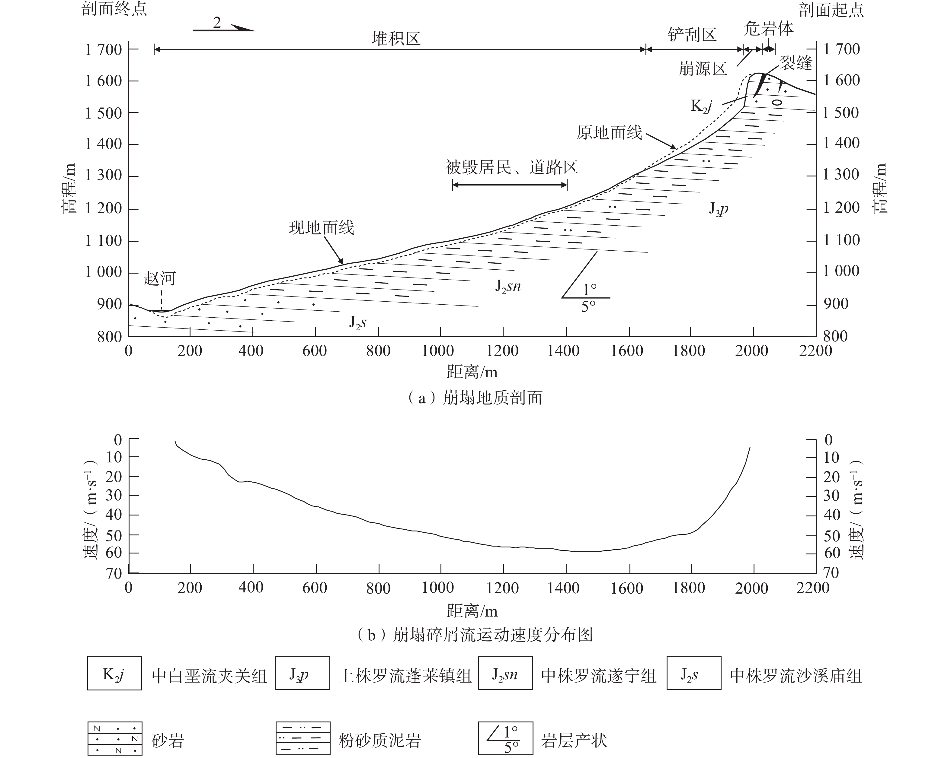
![]()
图 3 剖面图和进度分布图
Figure 3. Geological cross-section diagram of the rockfall and velocity distribution of the debris flow movement
![]()
图 4 铁匠湾崩塌源区多期遥感影像对比图
Figure 4. Multi-period remote sensing images comparison of the source area of the Tiejiangwan rockfall
![]()
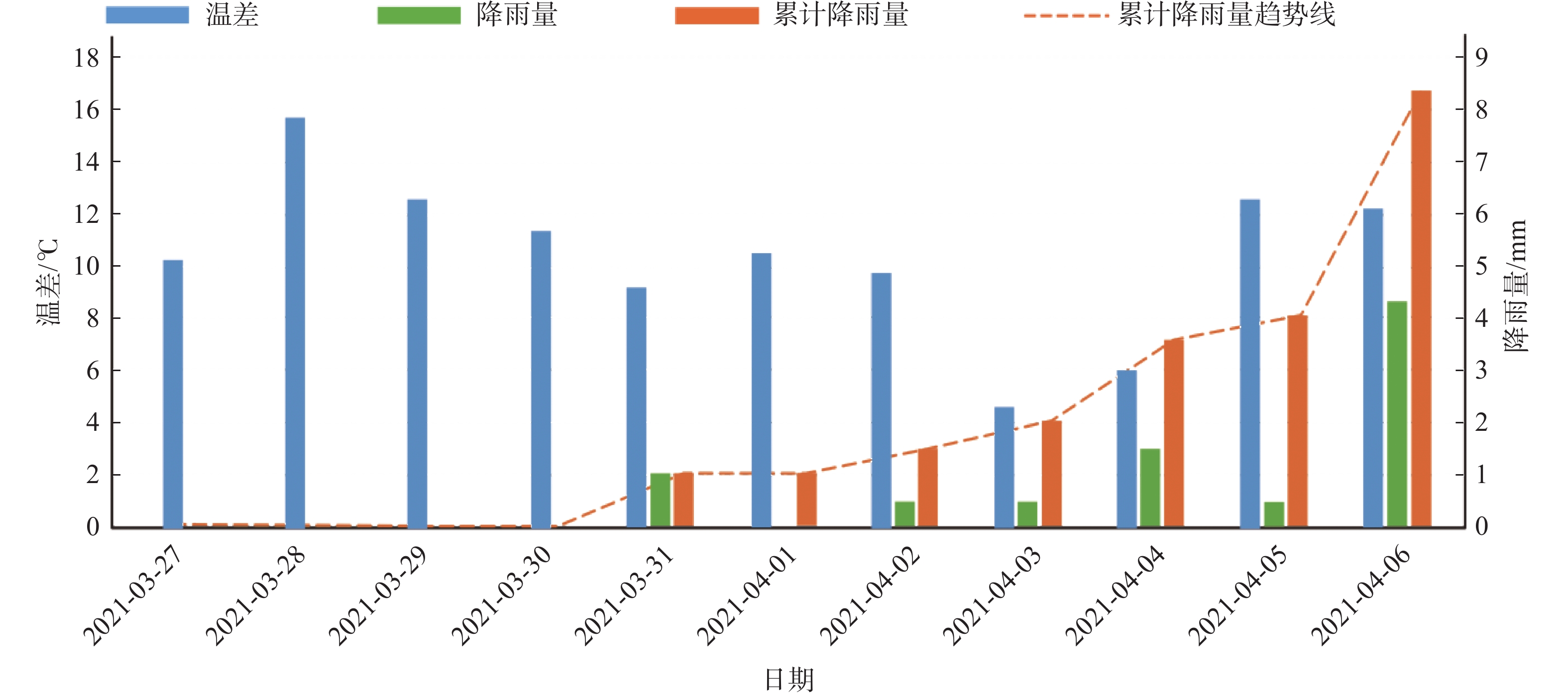
图 5 崩塌前降雨过程和温差变化柱状图
Figure 5. Histogram of rainfall process and temperature variation before rockfall
![]()
图 6 铁匠湾陡崖区及潜在崩塌隐患分布图
注:a为陡崖区WorldView-2光学卫星影像;b—d为陡崖区野外照片;e—j为潜在崩塌隐患WorldView-2光学卫星影像。
Figure 6. Distribution map of the steep cliff area and potential rockfalls in the Tiejiangwan area
表 1 铁匠湾崩塌光学遥感精细解译统计表
Table 1 Statistical table of optical remote sensing interpretation in Tiejiangwan rockfall
名称 编号 面积/m2 厚度/m 估算体积/(104 m3) 潜在崩源区 Ⅰ 2311 110 25.42 崩源区 Ⅱ 9578 110 105.36 铲刮区 Ⅲ 30573 15 45.86 堆积区 Ⅳ 146296 10 146.30 流水二次搬运堆积区 Ⅴ 8852 3 2.66 扰动变形区 A 4836 15 7.25 B 2874 10 2.87 C 9190 5 4.60 D 3104 5 1.55 E 2004 5 1.00  下载: 导出CSV
-
[1] 徐瑞春, 周建军. 红层与大坝[M]. 2版. 武汉: 中国地质大学出版社, 2010 XU Ruichun, ZHOU Jianjun. Red beds and dams[M]. 2nd ed. Wuhan: China University of Geosciences Press, 2010. (in Chinese with English abstract)
[2] 黄绍槟,程强,胡厚田. 四川红层分布及工程环境特征研究[J]. 公路,2005,50(5):81 − 85. [HUANG Shaobin,CHENG Qiang,HU Houtian. A study on distribution of Sichuan red beds and engineering environment characteristics[J]. Highway,2005,50(5):81 − 85. (in Chinese with English abstract) DOI: 10.3969/j.issn.0451-0712.2005.05.019 HUANG Shaobin, CHENG Qiang, HU Houtian. A study on distribution of Sichuan red beds and engineering environment characteristics[J]. Highway, 2005, 50(5): 81-85. (in Chinese with English abstract) DOI: 10.3969/j.issn.0451-0712.2005.05.019
[3] 彭华,吴志才. 关于红层特点及分布规律的初步探讨[J]. 中山大学学报(自然科学版),2003,42(5):109 − 113. [PENG Hua,WU Zhicai. A preliminary study on the characteristics and the distribution of red beds[J]. Acta Scientiarum Naturalium Universitatis Sunyatseni,2003,42(5):109 − 113. (in Chinese with English abstract) Peng Hua, Wu Zhicai. A preliminary study on the characteristics and the distribution of red beds[J]. Acta Scientiarum Naturalium Universitatis Sunyatseni, 2003, 42(5)109-113(in Chinese with English abstract)
[4] 曹先康,温智,陈海兰. 四川巴中市红层地区滑坡发育特征与防范措施[J]. 中国地质灾害与防治学报,2019,30(6):20 − 24. [CAO Xiankang,WEN Zhi,CHEN Hailan. Landslide development characteristics and preventive measures in the area with red beds in Bazhong City,Sichuan Province[J]. The Chinese Journal of Geological Hazard and Control,2019,30(6):20 − 24. (in Chinese with English abstract) DOI: 10.16031/j.cnki.issn.1003-8035.2019.06.03 CAO Xiankang, WEN Zhi, CHEN Hailan. Landslide development characteristics and preventive measures in the area with red beds in Bazhong City, Sichuan Province[J]. The Chinese Journal of Geological Hazard and Control, 2019, 30(6)20-24(in Chinese with English abstract) DOI: 10.16031/j.cnki.issn.1003-8035.2019.06.03
[5] 马贤杰,张玉芳,侯李杰,等. 红层地区滑坡的分类及形成机制[J]. 铁道建筑,2021,51(2):75 − 78. [MA Xianjie,ZHANG Yufang,HOU Lijie,et al. Study on classification and formation mechanism of landslide in red bed area[J]. Railway Engineering,2021,51(2):75 − 78. (in Chinese with English abstract) DOI: 10.3969/j.issn.1003-1995.2021.02.18 MA Xianjie, ZHANG Yufang, HOU Lijie, et al. Study on classification and formation mechanism of landslide in red bed area[J]. Railway Engineering, 2021, 51(2): 75-78. (in Chinese with English abstract) DOI: 10.3969/j.issn.1003-1995.2021.02.18
[6] 张涛,谢忠胜,石胜伟,等. 川东红层缓倾岩质滑坡的演化过程及其识别标志探讨[J]. 工程地质学报,2017,25(2):496 − 503. [ZHANG Tao,XIE Zhongsheng,SHI Shengwei,et al. Discussion on evolution process of flat rock landslide and its identification in red strata at eastern Sichuan[J]. Journal of Engineering Geology,2017,25(2):496 − 503. (in Chinese with English abstract) DOI: 10.13544/j.cnki.jeg.2017.02.029 ZHANG Tao, XIE Zhongsheng, SHI Shengwei, et al. Discussion on evolution process of flat rock landslide and its identification in red strata at eastern Sichuan[J]. Journal of Engineering Geology, 2017, 25(2): 496-503. (in Chinese with English abstract) DOI: 10.13544/j.cnki.jeg.2017.02.029
[7] 王家柱,葛华,高延超,等. 川南红层区黄子树滑坡形成过程与运动特征[J]. 中国地质灾害与防治学报,2020,31(2):9 − 17. [WANG Jiazhu,GE Hua,GAO Yanchao,et al. Mechanism and kinematic characteristics of Huangzishu Landslide in the red mudstone of southern Sichuan[J]. The Chinese Journal of Geological Hazard and Control,2020,31(2):9 − 17. (in Chinese with English abstract) DOI: 10.16031/j.cnki.issn.1003-8035.2020.02.02 WANG Jiazhu, GE Hua, GAO Yanchao, et al. Mechanism and kinematic characteristics of Huangzishu Landslide in the red mudstone of southern Sichuan[J]. The Chinese Journal of Geological Hazard and Control, 2020, 31(2): 9-17. (in Chinese with English abstract) DOI: 10.16031/j.cnki.issn.1003-8035.2020.02.02
[8] 徐伟,冉涛,田凯. 西南红层地区地质灾害发育规律与成灾模式—以云南彝良县为例[J]. 中国地质灾害与防治学报,2021,32(6):127 − 133. [XU Wei, RAN Tao,TIAN Kai. Developing law and disaster modes of geohazards in red bed region of southwestern China:A case study of Yiliang County of Yunnan Province[J]. The Chinese Journal of Geological Hazard and Control,2021,32(6):127 − 133. (in Chinese with English abstract) WEI Xu, TAO Ran, KAI Tian. Developing law and disaster modes of geohazards in red bed region of southwestern China: a case study of Yiliang County of Yunnan Province[J]. The Chinese Journal of Geological Hazard and Control, 2021, 32(6): 127-133. (in Chinese with English abstract)
[9] 王军朝,孙金辉. 川东红层缓倾角岩质崩塌特征与稳定性分析[J]. 地质力学学报,2019,25(6):1091 − 1098. [WANG Junchao,SUN Jinhui. Characteristics and stability analysis of rock collapse of low-angled red-bed slope in east Sichuan[J]. Journal of Geomechanics,2019,25(6):1091 − 1098. (in Chinese with English abstract) DOI: 10.12090/j.issn.1006-6616.2019.25.06.092 WANG Junchao, SUN Jinhui. Characteristics and stability analysis of rock collapse of low-angled red-bed slope in east Sichuan[J]. Journal of Geomechanics, 2019, 25(6): 1091-1098. (in Chinese with English abstract) DOI: 10.12090/j.issn.1006-6616.2019.25.06.092
[10] 胡斌,黄润秋. 软硬岩互层边坡崩塌机理及治理对策研究[J]. 工程地质学报,2009,17(2):200 − 205. [HU Bin,HUANG Runqiu. Collapse mechanism and treatment measures of slopes with interbeddings of soft and hard rocks[J]. Journal of Engineering Geology,2009,17(2):200 − 205. (in Chinese with English abstract) DOI: 10.3969/j.issn.1004-9665.2009.02.008 HU Bin, HUANG Runqiu. Collapse mechanism and treatment measures of slopes with interbeddings of soft and hard rocks[J]. Journal of Engineering Geology, 2009, 17(2): 200-205. (in Chinese with English abstract) DOI: 10.3969/j.issn.1004-9665.2009.02.008
[11] 郭永春,谢强,文江泉. 我国红层分布特征及主要工程地质问题[J]. 水文地质工程地质,2007,34(6):67 − 71. [GUO Yongchun,XIE Qiang,WEN Jiangquan. Red beds distribution and engineering geological problem in China[J]. Hydrogeology & Engineering Geology,2007,34(6):67 − 71. (in Chinese with English abstract) DOI: 10.3969/j.issn.1000-3665.2007.06.016 GUO Yongchun, XIE Qiang, WEN Jiangquan. Red beds distribution and engineering geological problem in China[J]. Hydrogeology & Engineering Geology, 2007, 34(6): 67-71. (in Chinese with English abstract) DOI: 10.3969/j.issn.1000-3665.2007.06.016
[12] 李江,许强,胡泽铭,等. 红层缓倾角土质滑坡发育环境、分布规律及影响因素研究[J]. 科学技术与工程,2014,14(12):88 − 93. [LI Jiang,XU Qiang,HU Zeming,et al. Study on development environment,distribution characteristics and factors of soil landslides on low-angled rock formation of red bed[J]. Science Technology and Engineering,2014,14(12):88 − 93. (in Chinese with English abstract) DOI: 10.3969/j.issn.1671-1815.2014.12.017 LI Jiang, XU Qiang, HU Zeming, et al. Study on development environment, distribution characteristics and factors of soil landslides on low-angled rock formation of red bed[J]. Science Technology and Engineering, 2014, 14(12)88-93(in Chinese with English abstract) DOI: 10.3969/j.issn.1671-1815.2014.12.017
[13] 张群,许强,易靖松,等. 南江红层地区缓倾角浅层土质滑坡降雨入渗深度与成因机理研究[J]. 岩土工程学报,2016,38(8):1447 − 1455. [ZHANG Qun,XU Qiang,YI Jingsong,et al. Rainfall infiltration depthand formation mechanism ofslow-inclination soillandslides in Nanjiang[J]. Chinese Journal of Geotechnical Engineering,2016,38(8):1447 − 1455. (in Chinese with English abstract) DOI: 10.11779/CJGE201608012 ZHANG Qun, XU Qiang, YI Jingsong, et al. Rainfall infiltration depthand formation mechanism ofslow-inclination soillandslides in Nanjiang[J]. Chinese Journal of Geotechnical Engineering, 2016, 38(8): 1447-1455. (in Chinese with English abstract) DOI: 10.11779/CJGE201608012
[14] 廖勇,乐建,胡力,等. 基于Fredlund & Xing模型的渗流分析在川东红层梯田滑坡中的应用[J]. 水文地质工程地质,2023,50(3):104 − 114. [LIAO Yong, LE Jian, HU Li, et al. Application of seepage analyses based on Fredlund & Xing model in red beds terrace landslides in eastern Sichuan[J]. Hydrogeology & Engineering Geology,2023,50(3):104 − 114. (in Chinese with English abstract) [LIAO Yong, LE Jian, HU Li, et al. Application of seepage analyses based on Fredlund & Xing model in red beds terrace landslides in eastern Sichuan[J]. Hydrogeology & Engineering Geology, 2023, 50(3): 104-114.(in Chinese with English abstract)
[15] 郭永春,赵峰先,闫圣龙,等. 红层泥岩三轴膨胀力的试验研究[J]. 水文地质工程地质,2022,49(3):87 − 93. [GUO Yongchun, ZHAO Fengxian, YAN Shenglong, et al. An experimental study of the triaxial expansion force of red-bed mudstone[J]. Hydrogeology & Engineering Geology,2022,49(3):87 − 93. (in Chinese with English abstract) GUO Yongchun, ZHAO Fengxian, YAN Shenglong, et al. An experimental study of the triaxial expansion force of red-bed mudstone[J]. Hydrogeology & Engineering Geology, 2022, 49(3): 87-93.(in Chinese with English abstract)
[16] 杨成忠,杨鹏,王威,等.红层泥质砂岩隧道进口段注浆加固及效果评价[J]. 水文地质工程地质,2018,45(3):98 − 105. [YANG Chengzhong, YANG Peng, WANG Wei, et al. Grouting reinforcement and effect evaluation of the inlet section of a red-layer shaly sandstone tunnel[J]. Hydrogeology & Engineering Geology,2018,45(3):98 − 105. (in Chinese with English abstract) [YANG Chengzhong, YANG Peng, WANG Wei, et al. Grouting reinforcement and effect evaluation of the inlet section of a red-layer shaly sandstone tunnel[J]. Hydrogeology & Engineering Geology, 2018, 45(3): 98-105.(in Chinese with English abstract)
[17] 四川省地质局第二区域地质测量队. 峨眉幅1∶20万区域地质测量报[R]. 1971 The second regional geological survey team of Sichuan Geological Bureau. Emei 1 ∶ 200000 regional geological survey report[R]. 1971. (in Chinese)
[18] SCHEIDEGGER A E. On the prediction of the reach and velocity of catastrophic landslides[J]. Rock Mechanics,1973,5(4):231 − 236. DOI: 10.1007/BF01301796


计量
- 文章访问数: 1868
- HTML全文浏览量: 2065
- PDF下载量: 306
 邮件订阅
邮件订阅 RSS
RSS