
Evaluation of geological hazard susceptibility of collapse and landslide in Yuanyang County using slope units and random forest modeling
-
摘要: 针对基于栅格单元与定性定量方法模型在地质灾害易发性评价中存在模型预测精度低且使用较为频繁的不足与弊端,采用斜坡单元与机器学习方法之一的随机森林模型相结合开展元阳县崩滑地质灾害易发性评价。在ArcGIS中,利用曲率分水岭法划分出7851个斜坡单元。经过大量统计研究与地质环境条件分析,选取工程地质岩组、地貌类型、高程、坡度、坡向、曲率、起伏度、河流距离、断层距离等9个因子作为评价指标,并通过SPSS软件,将9个评价指标与灾点发育特征的关系进行数据分析,得出各评价指标权重。在SPSS中,采用随机森林模型,建立易发性评价模型,将元阳县崩滑地质灾害易发性划分为低、中、高、极高4类,所占面积分别为410.06 km2、470.21 km2、550.02 km2和776.87 km2,分别占元阳县面积的18.58%、21.30%、24.92%和35.20%。经与详查结果对比,评价结果与实际高度吻合。利用ROC曲线得出区划结果精度AUC值为92.7%,区划结果相当好。研究显示,元阳县中部和西南两个部分地质灾害集中,易发性极高。Abstract: The model based on grid unit and qualitative and quantitative method has the disadvantages of low prediction accuracy and frequent use in the evaluation of geological hazard susceptibility, was utilized to evaluate the potential for collapse and landslide in Yuanyang County. Using ArcGIS, 7851 slope units were divided via the curvature watershed method. Through a large number of statistical study and analysis of geological environment condition, nine evaluation factors were selected, including engineering geological petrofabric, landform type, elevation, gradient, slope direction, curvature, ups and downs, rivers, distance and fault distance. These factors were analyzed and their weights determined using SPSS software, in conjunction with data on the development characteristics of disaster points. The random forest model was then applied to establish a vulnerability evaluation model, which categorized landslide geological disaster in Yuanyang County into four types: low, medium, high and extremely high, occupying an area of 410.06 km2, 470.21 km2, 550.02 km2 and 776.87 km2 respectively. These areas correspond to 18.58%, 21.30%, 24.92% and 35.20% of Yuanyang County’s total area. The evaluation results were compared with the detailed investigation results and were found to be highly consistent. The accuracy of ROC curve was calculated at 92.7%, indicating a high level of accuracy. The central and southwest parts of Yuanyang County were found to be highly susceptible to geological disasters.
-
0. 引言
地质灾害易发性评价的两个核心部分为评价方法的建立与评价单元的选取,这两个选取因素将影响到易发性评价工作的科学性以及合理性。现在对于地质灾害易发性评价选取得评价单元有栅格单元、斜坡单元、流域单元等,殷坤龙等[1]、田述军等[2]、王磊等[3]采用栅格单元对地质灾害易发性评价,因其划分方法简单且易于操作深受工作者及学者的喜爱,而对于斜坡单元,因其划分复杂,计算操作过程较为繁复,相对运用较少。于成龙[4]、朱浩濛等[5]、赵晓燕等[6]采用斜坡单元对地质灾害易发性评价,但对斜坡单元具体的划分以及对斜坡评价单元的合理运用等相关研究较少。对比其他评价单元,斜坡单元充分考虑到了研究区的地形起伏、地质构造等环境因素,对于地质灾害易发性评价有较高的准确性。目前国内外地质灾害易发性评价方法中,地质灾害危险性评价数学模型包括基于统计学方法的确定性系数法[7]、证据权重法[8]、信息量法[3]、支持向量机法[9]、模糊评判法、线性回归分析法等,基于非统计学方法的专家打分法、层次分析法,多种方法耦合分析等[3],以及随机森林[10]等各类机器学习模型。在不同地质环境条件影响下,各类方法模型各具特点。
本文在元阳县地质环境条件调查和分析的基础上,结合随机森林模型,充分发挥了斜坡单元自身特点和优势,将每个单元作为独立地质环境个体参与建模,从而得到较高预测精度与较为合理的评价结果。本文斜坡单元与随机森林模型在地质灾害易发性评价中的应用可为元阳县地质灾害防治与土地利用规划提供科学的参考和依据,并为其它地质环境复杂的研究区地质灾害易发性评价提供借鉴。
1. 研究区概况
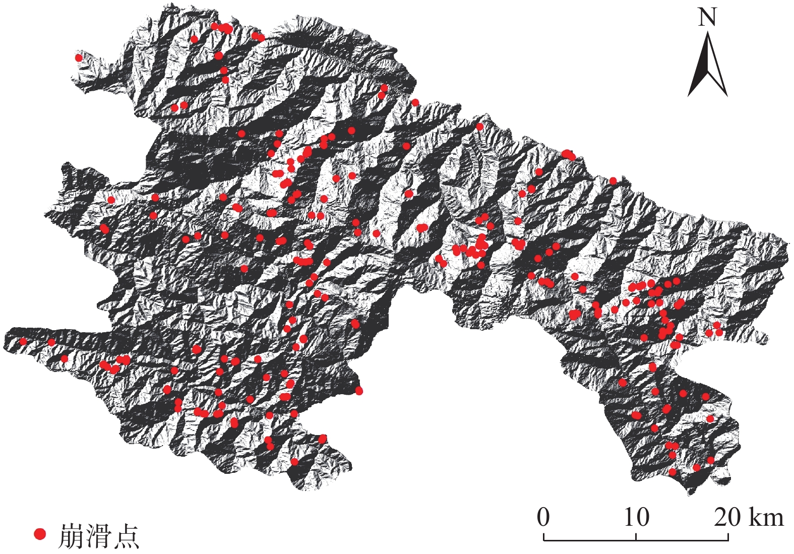
元阳县位于云南省南部哀牢山脉南段,红河州西南部红河南岸。东接金平县,南连绿春县,西邻红河县,北与建水县、个旧市、蒙自市隔红河相望,东西横跨74 km,南北纵距55 km,面积2189.88 km2[11-12]。地处哀牢山脉南段,山高谷深,沟壑纵横,属深切割中山地貌类型。县境北受红河、南受藤条江水系深切,断面成“V”形发育,形成中部高,两侧低,地势由西北向东南倾斜。最高海拔处为白岩子山,海拔2939.6 m,最低海拔处为与金平交界的小河口,海拔144 m,相对高差2795.6 m。历经华里西运动及喜马拉雅造山运动,形成区内侵蚀剥蚀低山地貌、岩溶中山地貌、堆积河谷地貌、构造侵蚀中山地貌四种基本地貌单元。区内地质构造复杂,新构造运动强烈,元阳县地层以元古界哀牢山群花岗侵入岩分布最广。岩体抗风化能力较弱,岩层破碎,裂隙发育。坡地垦殖、基础设施建设、矿产资源开采等是目前最主要的人类工程活动。根据野外调查显示,元阳县共有崩塌、滑坡等地质灾害259个灾害点。其中,滑坡231个,不稳定斜坡21个,崩塌7个(图1)。
![]() 图 1 元阳县崩滑灾点分布图Figure 1. Distribution map of collapse and landslide disaster sites in Yuanyang County
图 1 元阳县崩滑灾点分布图Figure 1. Distribution map of collapse and landslide disaster sites in Yuanyang County由于崩塌、滑坡与泥石流受控因素有很大区别,所以本文只对崩塌、滑坡地质灾害进行易发性评价。
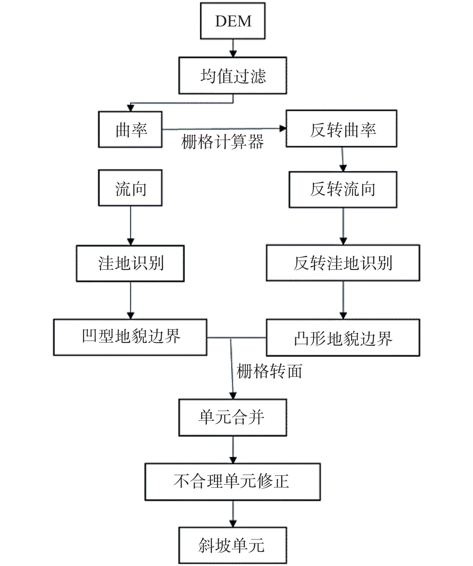
2. 斜坡单元划分流程及划分结果
斜坡单元对局部地区的地形地貌有较好的表现作用,对崩塌滑坡等地质灾害有较强的控制作用。划分的精度要满足当地地质灾害易发性评价,并且与实地相吻合[13-18]。
本文利用曲率分水岭法在ArcGIS中对元阳县DEM进行(图2)操作,阈值设置1000,3000,5000三种情况下分别对元阳县进行斜坡单元的划分,最后经对比修改,阈值3000情况下的斜坡单元与实地最为吻合,最终将研究区划分为7851个斜坡单元(图3)。
3. 易发性区划及结果分析
3.1 评价指标因子选取
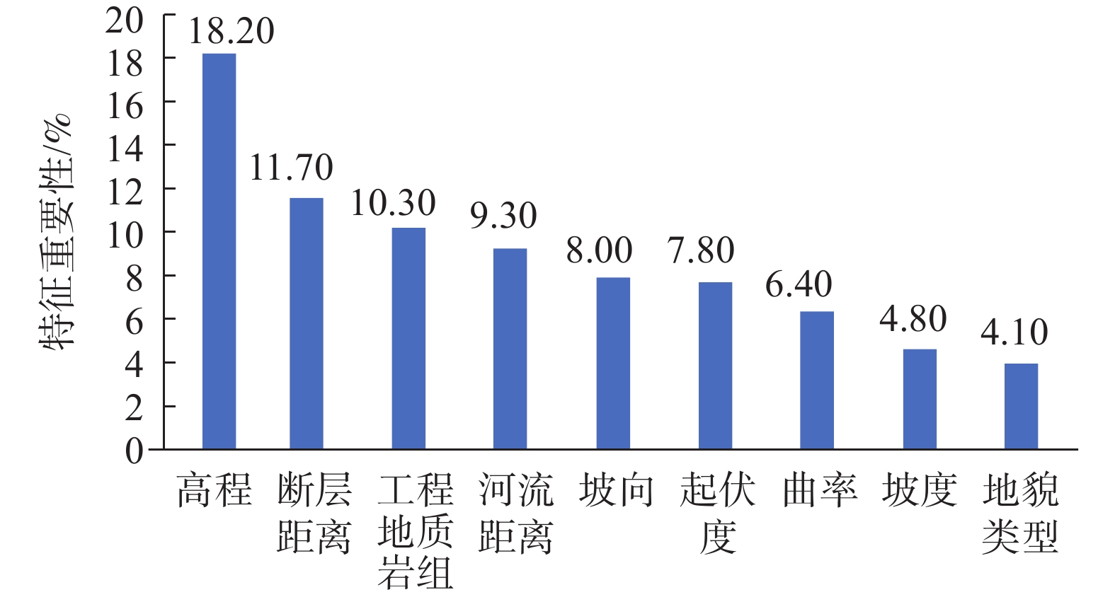
通过对元阳县地质环境的分析与崩塌、滑坡地质灾害分布规律的研究统计,并对前人评价因子选取研究进行统计分析对比后,选取工程地质岩组、地貌类型、高程、坡度、坡向、曲率、起伏度、河流距离、断层距离出现频数最多的9个因子作为评价指标,并对每个评价指标进行量化分级。在SPSS中通过分析崩塌滑坡灾点分布与各评价因子分级的数量关系,确定元阳县地质灾害易发性各评价因子的权重大小(图4)。
由评价因子特征重要性图可以看出,上述选取的9个评价因子在与崩滑地质灾害发育的关系中均占有一定比重且高程所占的比重最大,因此可作为地质灾害易发性评价因子参与计算。
3.2 随机森林模型建立
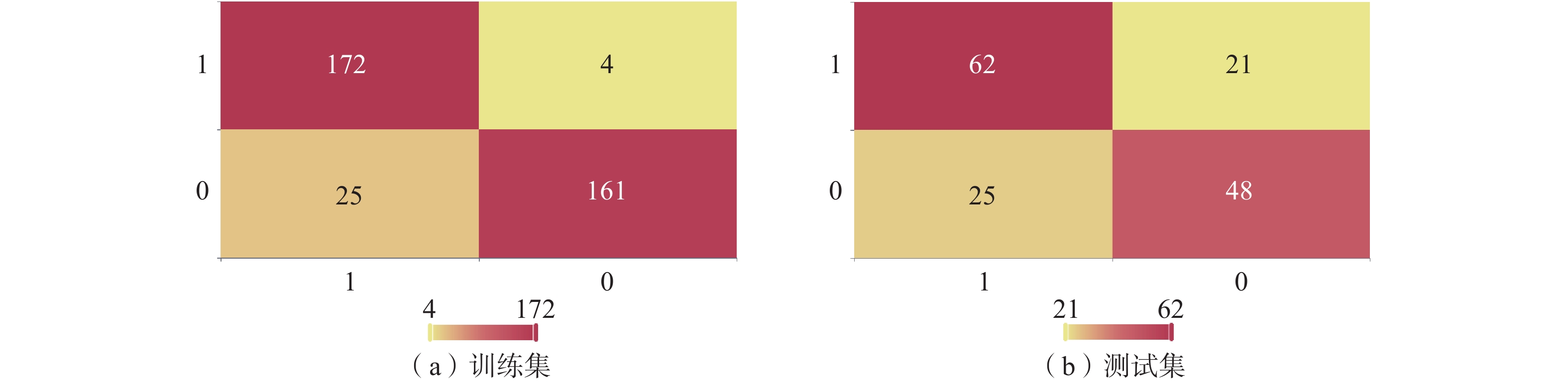
随机森林是利用多棵决策树进行分类的一种机器学习方法,可以对大量的高纬数据进行分类[4]。随机森林模型对异常值有很高的容忍度,另外每个斜坡单元所占区域面积较大,可能会存在不同的地质环境因素,所以采用机器学习的随机森林模型预测精度较高。首先需要在ArcGIS中距离崩滑灾点800 m距离上随机生成等量的非灾点共518个样本,赋予相应评价因子属性后,参与建立随机森林模型,模型参数如表1所示,将崩滑点与非崩滑点随机分成70%∶30%的比例,作为训练集和测试集(图5),放入SPSS软件中,调整合适参数使得训练集与测试集精度尽可能高,建立随机森林模型,数据集精确率如表2所示。最后将每个斜坡单元赋予选取得9个评价指标的属性,并调整相应权重,放入所得随机森林模型中进行预测[19-24]。
表 1 随机森林模型参数Table 1. Summary table of Random forest model parameters参数名 参数值 训练用时/s 0.156 数据切分 0.7 数据洗牌 是 交叉验证 否 节点分裂评价准则 gini 决策树数量 100 有放回采样 TRUE 袋外数据测试 FALSE 划分时考虑的最大特征比例 auto 内部节点分裂的最小样本数 2 叶子节点的最小样本数 1 叶子节点中样本的最小权重 0 树的最大深度 10 叶子节点的最大数量 50 节点划分不纯度的阈值 0 表 2 数据集精确率Table 2. Summary table of dataset accuracy准确率 召回率 精确率 F1 训练集 0.920 0.920 0.926 0.920 测试集 0.705 0.705 0.705 0.704 注:F1为精确率和召回率的调和平均。 3.3 评价结果分析
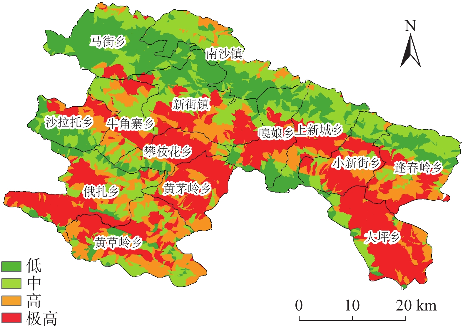
利用ArcGIS中的自然间断点法对随机森林模型得出的斜坡单元致灾预测概率值进行分类,并分成低、中、高和极高4类易发性等级,得到元阳县地质灾害易发性区划图(图6)。
基于以上研究区地质灾害易发性区划结果的合理性与科学性,本文将结合地质特点对结果进行探讨和分析。
元阳县崩滑地质灾害易发性区划结果显示,低、中、高、极高易发区所占面积分别为410.06 km2、470.21 km2、550.02 km2和776.87 km2,分别占元阳县面积的18.58%、21.30%、24.92%和35.20%,所包含的灾点数分别为19、21、77、142个,分别占已知崩滑点的7.34%、8.11%、29.73%和54.83%(表3)。极高易发区呈带状分布在元阳县中部和西南部两部分,在攀枝花乡、黄草岭乡、嘎娘乡、上新城乡、小新街乡、大坪乡、俄扎乡,黄茅岭乡均有分布,高易发区集中分布于极高易发区两侧,中低易发区呈带状分布在元阳县北部,集中分布在马街乡、南沙镇等区域(图6)。
表 3 易发性分级数据统计Table 3. Sueceptibility classification data statistics易发性等级 灾点数 比重/% 区间面积/km2 比重/% 低 19 7.34 410.06 18.58 中 21 8.11 470.21 21.30 高 77 29.73 550.02 24.92 极高 142 54.83 776.87 35.20 4. 结果对比
4.1 精度评价
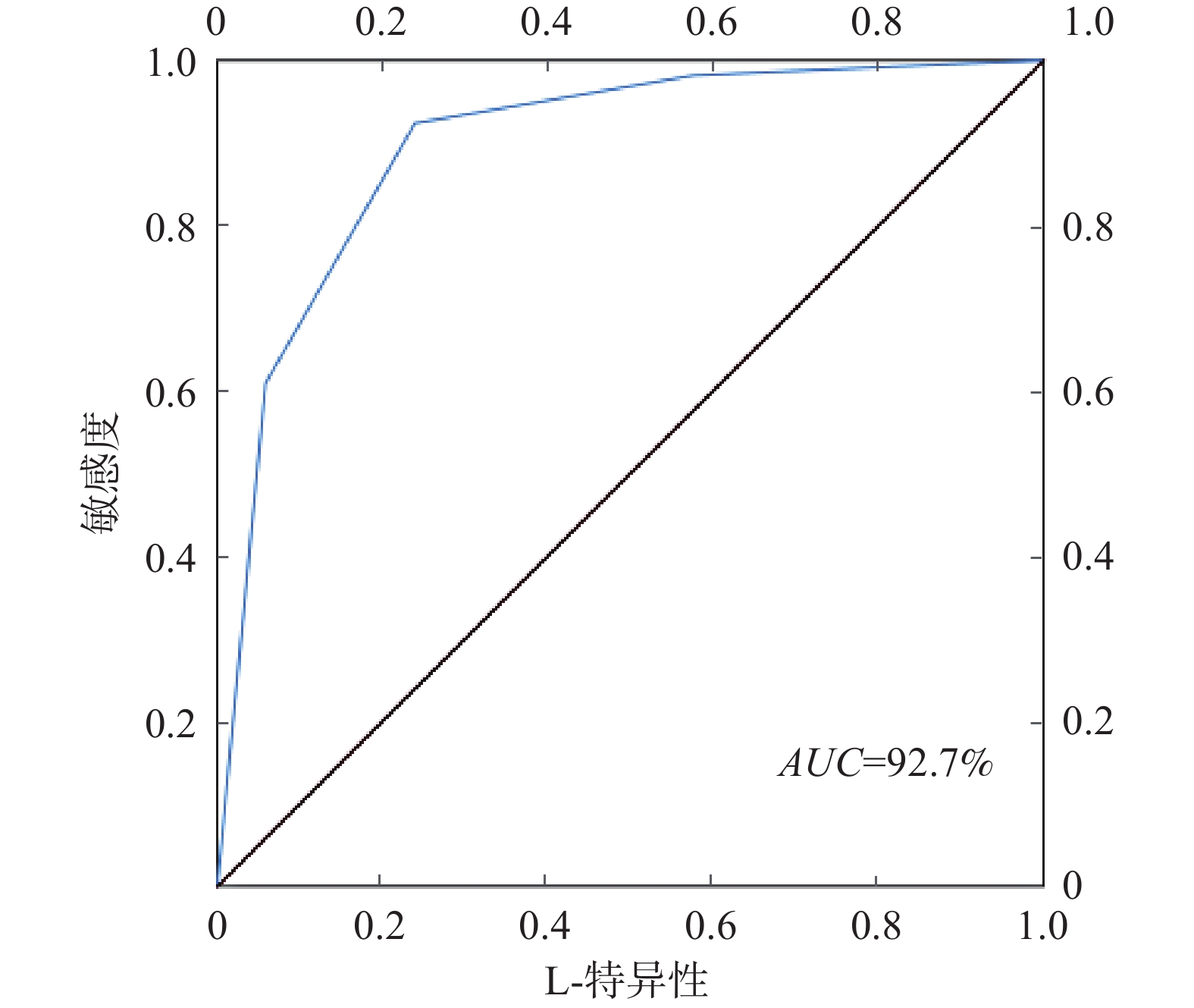
本文以ROC曲线作为评价结果进度检验方法,ROC曲线可以直观,简单地反映出评价结果的准确性。ROC曲线下的面积AUC值是检验易发性区划结果的好坏。AUC值在0.5~1:(1)相当好:AUC大于0.9小于1.0;(2)很好:AUC大于0.8小于0.9;(3)好:AUC大于0.7小于0.8;(4)差:AUC大于0.6小于0.7;(5)极差:AUC大于0.5小于0.6[4]。
由图7可知,元阳县崩滑地质灾害易发性区划结果的AUC值为92.7%,落入了“相当好”的区间。这说明地质灾害易发性区划结果具有很好的准确性。
4.2 与实际对比
将本文地质灾害易发性评价结果与元阳县地质灾害详细调查结果经过数据整理进行易发性评价结果对比。通过对本文易发性评价结果与详查易发性评价结果对比发现(表4),本文易发性评价结果所包含的灾点数和所占面积与实际相吻合,评价结果较为准确[24-29]。
表 4 评价结果对比表Table 4. Comparison table of evaluation results结果来源 易发性等级 灾点数 比重/% 区间面积/km2 比重/% 本文评价结果 低 19 7.34 410.06 18.58 中 21 8.11 470.21 21.30 高 77 29.73 550.02 24.92 极高 142 54.83 776.87 35.20 详查评价结果 低 0 0.00 369.70 16.75 中 19 7.34 511.18 23.16 高 80 30.89 591.30 26.79 极高 157 60.62 734.98 33.30 5. 结论
(1)以元阳县的崩塌、滑坡地质灾害点作为研究对象,运用SPSS软件对9个易发性评价因子进行权重分析,得出9个评价因子在易发性评价中均占有一定比重,且高程特征重要性最大,占18.20%,其次为断层距离和工程地质岩组,分别占11.70%和10.30%。以斜坡单元作为评价单元,并结合随机森林模型开展了元阳县的地质灾害易发性区划,得到元阳县崩滑地质灾害易发性区划图。
(2)在ArcGIS中,利用曲率分水岭法,阈值调试3000,将元阳县划分为7851个斜坡单元。将得到的易发性分区与灾点个数及分区面积进行统计,得出元阳县易发性区划结果所包含灾点和所占面积与实际相吻合,低、中、高和极高易发区分别占元阳县面积的18.58%、21.30%、24.92%和35.20%,所包含的灾点数分别占已知崩滑点的7.34%、8.11%、29.73%和54.83%,因此易发性区划结果有较高的准确性。
(3)运用斜坡单元与机器学习法-随机森林模型的结合,将每个斜坡单元作为独立个体参与模型运算,得出的研究区易发性分区结果与实际较为吻合,利用ROC曲线对研究区易发性评价结果进行评价,得出AUC值为92.7%,元阳县易发性区划结果相当好。
-
![]()
图 1 元阳县崩滑灾点分布图
Figure 1. Distribution map of collapse and landslide disaster sites in Yuanyang County
表 1 随机森林模型参数
Table 1 Summary table of Random forest model parameters
参数名 参数值 训练用时/s 0.156 数据切分 0.7 数据洗牌 是 交叉验证 否 节点分裂评价准则 gini 决策树数量 100 有放回采样 TRUE 袋外数据测试 FALSE 划分时考虑的最大特征比例 auto 内部节点分裂的最小样本数 2 叶子节点的最小样本数 1 叶子节点中样本的最小权重 0 树的最大深度 10 叶子节点的最大数量 50 节点划分不纯度的阈值 0  下载: 导出CSV
表 2 数据集精确率
Table 2 Summary table of dataset accuracy
准确率 召回率 精确率 F1 训练集 0.920 0.920 0.926 0.920 测试集 0.705 0.705 0.705 0.704 注:F1为精确率和召回率的调和平均。
下载: 导出CSV
表 3 易发性分级数据统计
Table 3 Sueceptibility classification data statistics
易发性等级 灾点数 比重/% 区间面积/km2 比重/% 低 19 7.34 410.06 18.58 中 21 8.11 470.21 21.30 高 77 29.73 550.02 24.92 极高 142 54.83 776.87 35.20
下载: 导出CSV
表 4 评价结果对比表
Table 4 Comparison table of evaluation results
结果来源 易发性等级 灾点数 比重/% 区间面积/km2 比重/% 本文评价结果 低 19 7.34 410.06 18.58 中 21 8.11 470.21 21.30 高 77 29.73 550.02 24.92 极高 142 54.83 776.87 35.20 详查评价结果 低 0 0.00 369.70 16.75 中 19 7.34 511.18 23.16 高 80 30.89 591.30 26.79 极高 157 60.62 734.98 33.30
下载: 导出CSV
-
[1] 殷坤龙,张桂荣. 地质灾害风险区划与综合防治对策[J]. 安全与环境工程,2003,10(1):32 − 35. [YIN Kunlong,ZHANG Guirong. Risk zonation of geo-hazards and its comprehensive control[J]. Safety and Environmental Engineering,2003,10(1):32 − 35. (in Chinese with English abstract) DOI: 10.3969/j.issn.1671-1556.2003.01.010 YIN Kunlong, ZHANG Guirong. Risk zonation of geo-hazards and its comprehensive control[J]. Safety and Environmental Engineering, 2003, 10(1): 32-35. (in Chinese with English abstract) DOI: 10.3969/j.issn.1671-1556.2003.01.010
[2] 田述军,张珊珊,唐青松,等. 基于不同评价单元的滑坡易发性评价对比研究[J]. 自然灾害学报,2019,28(6):137 − 145. [TIAN Shujun,ZHANG Shanshan,TANG Qingsong,et al. Comparative study of landslide susceptibility assessment based on different evaluation units[J]. Journal of Natural Disasters,2019,28(6):137 − 145. (in Chinese with English abstract) DOI: 10.13577/j.jnd.2019.0615 TIAN Shujun, ZHANG Shanshan, TANG Qingsong, et al. Comparative study of landslide susceptibility assessment based on different evaluation units[J]. Journal of Natural Disasters, 2019, 28(6): 137-145. (in Chinese with English abstract) DOI: 10.13577/j.jnd.2019.0615
[3] 王磊,常鸣,邢月龙. 基于信息量法模型与GIS的滑坡地质灾害风险性评价[J]. 地质灾害与环境保护,2021,32(2):14 − 20. [WANG Lei,CHANG Ming,XING Yuelong. Risk assessment of landslide geological hazards based on information method model and GIS[J]. Journal of Geological Hazards and Environment Preservation,2021,32(2):14 − 20. (in Chinese with English abstract) DOI: 10.3969/j.issn.1006-4362.2021.02.003 WANG Lei, CHANG Ming, XING Yuelong. Risk assessment of landslide geological hazards based on information method model and GIS[J]. Journal of Geological Hazards and Environment Preservation, 2021, 32(2): 14-20. (in Chinese with English abstract) DOI: 10.3969/j.issn.1006-4362.2021.02.003
[4] 于成龙. 和龙市典型地质灾害风险性区划与地质环境承载力综合评价研究[D]. 长春: 吉林大学, 2021 YU Chenglong. Study on risk mapping of typical geological hazards and comprehensive evaluation of geological environment carrying capacity in Helong City[D]. Changchun: Jilin University, 2021. (in Chinese with English abstract)
[5] 朱浩濛, 马晓峰, 张义顺. 基于斜坡单元下的层次分析法在地质灾害易发性区划中的应用[C]//防治地灾 除险安居——浙江省地质学会2017年学术年会论文集. 杭州, 2017: 79 − 84. ZHU Haomeng, MA Xiaofeng, ZHANG Yishun. Application of analytic hierarchy process based on slope unit in geological disaster-prone regionalization[C]//Prevention and control of local disasters, removal of risks and housing: Proceedings of the 2017 Academic Annual Conference of Zhejiang Geological Society. Hangzhou, 2017: 79 − 84.
[6] 赵晓燕,谈树成,李永平. 基于斜坡单元与组合赋权法的东川区地质灾害危险性评价[J]. 云南大学学报(自然科学版),2021,43(2):299 − 305. [ZHAO Xiaoyan,TAN Shucheng,LI Yongping. Risk assessment of geological hazards in Dongchuan District based on the methods of slope unit and combination weighting[J]. Journal of Yunnan University (Natural Sciences Edition),2021,43(2):299 − 305. (in Chinese with English abstract) ZHAO Xiaoyan, TAN Shucheng, LI Yongping. Risk assessment of geological hazards in Dongchuan District based on the methods of slope unit and combination weighting[J]. Journal of Yunnan University (Natural Sciences Edition), 2021, 43(2): 299-305. (in Chinese with English abstract)
[7] 李益敏,李驭豪,赵志芳. 基于确定性系数模型的泸水市泥石流易发性评价[J]. 水土保持研究,2019,26(4):336 − 342. [LI Yimin,LI Yuhao,ZHAO Zhifang. Assessment on susceptibility of debris flow in Lushui based on the certain factor model[J]. Research of Soil and Water Conservation,2019,26(4):336 − 342. (in Chinese with English abstract) DOI: 10.13869/j.cnki.rswc.2019.04.050 LI Yimin, LI Yuhao, ZHAO Zhifang. Assessment on susceptibility of debris flow in Lushui based on the certain factor model[J]. Research of Soil and Water Conservation, 2019, 26(4): 336-342. (in Chinese with English abstract) DOI: 10.13869/j.cnki.rswc.2019.04.050
[8] 胡燕,李德营,孟颂颂,等. 基于证据权法的巴东县城滑坡灾害易发性评价[J]. 地质科技通报,2020,39(3):187 − 194. [HU Yan,LI Deying,MENG Songsong,et al. Landslide susceptibility evaluation in Badong County based on weights of evidence method[J]. Bulletin of Geological Science and Technology,2020,39(3):187 − 194. (in Chinese with English abstract) HU Yan, LI Deying, MENG Songsong, et al. Landslide susceptibility evaluation in Badong County based on weights of evidence method[J]. Bulletin of Geological Science and Technology, 2020, 39(3): 187-194. (in Chinese with English abstract)
[9] 牛瑞卿,彭令,叶润青,等. 基于粗糙集的支持向量机滑坡易发性评价[J]. 吉林大学学报(地球科学版),2012,42(2):430 − 439. [NIU Ruiqing,PENG Ling,YE Runqing,et al. Landslide susceptibility assessment based on rough sets and support vector machine[J]. Journal of Jilin University (Earth Science Edition),2012,42(2):430 − 439. (in Chinese with English abstract) NIU Ruiqing, PENG Ling, YE Runqing, et al. Landslide susceptibility assessment based on rough sets and support vector machine[J]. Journal of Jilin University (Earth Science Edition), 2012, 42(2): 430-439. (in Chinese with English abstract)
[10] 郑迎凯,陈建国,王成彬,等. 确定性系数与随机森林模型在云南芒市滑坡易发性评价中的应用[J]. 地质科技通报,2020,39(6):131 − 144. [ZHENG Yingkai,CHEN Jianguo,WANG Chengbin,et al. Application of certainty factor and random forests model in landslide susceptibility evaluation in Mangshi City,Yunnan Province[J]. Bulletin of Geological Science and Technology,2020,39(6):131 − 144. (in Chinese with English abstract) ZHENG Yingkai, CHEN Jianguo, WANG Chengbin, et al. Application of certainty factor and random forests model in landslide susceptibility evaluation in Mangshi City, Yunnan Province[J]. Bulletin of Geological Science and Technology, 2020, 39(6): 131-144. (in Chinese with English abstract)
[11] 陆跃萍. 从元阳县城滑坡灾害看山区城镇建设的环境因素[J]. 云南环境科学,1993,12(1):39 − 41. [LU Yueping. Environmental factors of urban construction in mountainous areas from landslide disaster in Yuanyang County[J]. Yunnan Environmental Science,1993,12(1):39 − 41. (in Chinese with English abstract) LU Yueping. Environmental factors of urban construction in mountainous areas from landslide disaster in Yuanyang County[J]. Yunnan Environmental Science, 1993, 12(1): 39-41. (in Chinese with English abstract)
[12] 戚琦. 基于GIS和目标层次联合分析方法的元阳县地质灾害易发程度评价研究[D]. 北京: 中国地质大学(北京), 2012 QI Qi. Study on the evaluation of the susceptibility of geological hazards occurring in Yuan yang County based on the combination of AHP and GIS[D]. Beijing: China University of Geosciences, 2012. (in Chinese with English abstract)
[13] 屠水云,张钟远,付弘流,等. 基于CF与CF-LR模型的地质灾害易发性评价[J]. 中国地质灾害与防治学报,2022,33(2):96 − 104. [TU Shuiyun,ZHANG Zhongyuan,FU Hongliu,et al. Geological hazard susceptibility evaluation based on CF and CF-LR model[J]. The Chinese Journal of Geological Hazard and Control,2022,33(2):96 − 104. (in Chinese with English abstract) DOI: 10.16031/j.cnki.issn.1003-8035.2022.02-12 TU Shuiyun, ZHANG Zhongyuan, FU Hongliu, et al. Geological hazard susceptibility evaluation based on CF and CF-LR model[J]. The Chinese Journal of Geological Hazard and Control, 2022, 33(2): 96-104. (in Chinese with English abstract) DOI: 10.16031/j.cnki.issn.1003-8035.2022.02-12
[14] 温鑫,范宣梅,陈兰,等. 基于信息量模型的地质灾害易发性评价—以川东南古蔺县为例[J]. 地质科技通报,2022,41(2):290 − 299. [WEN Xin,FAN Xuanmei,CHEN Lan,et al. Susceptibility assessment of geological disasters based on an information value model:A case of Gulin County in southeast Sichuan[J]. Bulletin of Geological Science and Technology,2022,41(2):290 − 299. (in Chinese with English abstract) WEN Xin, FAN Xuanmei, CHEN Lan, et al. Susceptibility assessment of geological disasters based on an information value model: a case of Gulin County in Southeast Sichuan[J]. Bulletin of Geological Science and Technology, 2022, 41(2): 290-299. (in Chinese with English abstract)
[15] 毕鸿基,聂磊,曾超,等. 基于三种多变量不安定指数分析模型的汶川县地质灾害易发性评价[J]. 中国地质灾害与防治学报,2022,33(1):123 − 131. [BI Hongji,NIE Lei,ZENG Chao,et al. Geological hazard susceptibility evaluation in Wenchuan area based on three models of multivariate instability index analysis[J]. The Chinese Journal of Geological Hazard and Control,2022,33(1):123 − 131. (in Chinese with English abstract) DOI: 10.16031/j.cnki.issn.1003-8035.2022.01-15 BI Hongji, NIE Lei, ZENG Chao, et al. Geological hazard susceptibility evaluation in Wenchuan area based on three models of multivariate instability index analysis[J]. The Chinese Journal of Geological Hazard and Control, 2022, 33(1): 123-131. (in Chinese with English abstract) DOI: 10.16031/j.cnki.issn.1003-8035.2022.01-15
[16] 韩用顺,孙湘艳,刘通,等. 基于证据权-投影寻踪模型的藏东南地质灾害易发性评价[J]. 山地学报,2021,39(5):672 − 686. [HAN Yongshun,SUN Xiangyan,LIU Tong,et al. Susceptibility evaluation of geological hazards based on evidence weight-projection pursuit model in southeast Tibet,China[J]. Mountain Research,2021,39(5):672 − 686. (in Chinese with English abstract) DOI: 10.16089/j.cnki.1008-2786.000629 HAN Yongshun, SUN Xiangyan, LIU Tong, et al. Susceptibility evaluation of geological hazards based on evidence weight-projection pursuit model in southeast Tibet, China[J]. Mountain Research, 2021, 39(5): 672-686. (in Chinese with English abstract) DOI: 10.16089/j.cnki.1008-2786.000629
[17] 祁于娜,王磊. 层次分析-熵值定权法应用于山区城镇地质灾害易发性评价[J]. 测绘通报,2021(6):112 − 116. [QI Yuna,WANG Lei. Application of AHP-entropy weight method in hazards susceptibility assessment in mountain town[J]. Bulletin of Surveying and Mapping,2021(6):112 − 116. (in Chinese with English abstract) DOI: 10.13474/j.cnki.11-2246.2021.0187 QI Yuna, WANG Lei. Application of AHP-entropy weight method in hazards susceptibility assessment in mountain town[J]. Bulletin of Surveying and Mapping, 2021(6): 112-116. (in Chinese with English abstract) DOI: 10.13474/j.cnki.11-2246.2021.0187
[18] 曹文霞. 基于组合赋权法的交口县地质灾害易发性评价研究[D]. 太原: 太原理工大学, 2021 CAO Wenxia. Study on geohazard susceptibility evaluation based on combination weighting method in Jiaokou Country[D]. Taiyuan: Taiyuan University of Technology, 2021. (in Chinese with English abstract)
[19] 孙长明,马润勇,尚合欣,等. 基于滑坡分类的西宁市滑坡易发性评价[J]. 水文地质工程地质,2020,47(3):173 − 181. [SUN Changming,MA Runyong,SHANG Hexin,et al. Landslide susceptibility assessment in Xining based on landslide classification[J]. Hydrogeology & Engineering Geology,2020,47(3):173 − 181. (in Chinese with English abstract) DOI: 10.16030/j.cnki.issn.1000-3665.201906074 SUN Changming, MA Runyong, SHANG Hexin, et al. Landslide susceptibility assessment in Xining based on landslide classification[J]. Hydrogeology & Engineering Geology, 2020, 47(3): 173-181. (in Chinese with English abstract) DOI: 10.16030/j.cnki.issn.1000-3665.201906074
[20] 姬永涛, 王鲜, 郝业, 等. 基于斜坡单元的陕西省城镇地质灾害风险调查评价——以西安市蒋村街道为例[J]. 灾害学, 2022,37(4): 211-219 JI Yongtao, WANG Xian, HAO Ye, et al. Investigation and evaluation of urban geological hazard risk based on slope unit in Shaanxi Province: A case study of Jiangcun street in Xi’an[J]. Disaster, 2022,37(4): 211-219. ( in Chinese with English abstract)
[21] 邹凤钗,冷洋洋,陶小郎,等. 基于斜坡单元的滑坡风险识别—以贵州万山浅层土质斜坡为例[J]. 中国地质灾害与防治学报,2022,33(3):114 − 122. [ZOU Fengchai,LENG Yangyang,TAO Xiaolang,et al. Landslide hazard identification based on slope unit:A case study of shallow soil slope in Wanshan,Guizhou Province[J]. The Chinese Journal of Geological Hazard and Control,2022,33(3):114 − 122. (in Chinese with English abstract) ZOU Fengchai, LENG Yangyang, TAO Xiaolang, et al. Landslide hazard identification based on slope unit: a case study of shallow soil slope in Wanshan, Guizhou Province[J]. The Chinese Journal of Geological Hazard and Control, 2022, 33(3): 114-122. (in Chinese with English abstract)
[22] 王家柱, 高延超, 铁永波, 等. 基于斜坡单元的山区城镇滑坡灾害易发性评价——以康定为例[J]. 沉积与特提斯地质: 1 − 17(2021-05-10)[2022-07-10]. WANG Jiazhu, GAO Yanchao, TIE Yongbo, et al. Evaluation of landslide hazard susceptibility in mountainous towns based on slope element: A case study of Kangding City[J]. Sedimentary and Tethyan Geology: 1 − 17(2021-05-10)[2022-07-10]. DOI: 10.19826/j.cnki.1009-3850.2021.03001.( in Chinese with English abstract)
[23] 胡瑞林,陈平,庄茂国,等. “坡长制斜坡地质灾害防治体系”的建立与技术要点[J]. 工程地质学报,2020,28(4):748 − 761. [HU Ruilin,CHEN Ping,ZHUANG Maoguo,et al. Establishment and technical essentials of slope-geohazard prevention system of slope-unit administrant[J]. Journal of Engineering Geology,2020,28(4):748 − 761. (in Chinese with English abstract) DOI: 10.13544/j.cnki.jeg.2020-057 HU Ruilin, CHEN Ping, ZHUANG Maoguo, et al. Establishment and technical essentials of slope-geohazard prevention system of slope-unit administrant[J]. Journal of Engineering Geology, 2020, 28(4): 748-761. (in Chinese with English abstract) DOI: 10.13544/j.cnki.jeg.2020-057
[24] 申泽西,张强,吴文欢,等. 青藏高原及横断山区地质灾害易发区空间格局及驱动因子[J]. 地理学报,2022,77(5):1211 − 1224. [SHEN Zexi,ZHANG Qiang,WU Wenhuan,et al. Spatial pattern and attribution analysis of the regions with frequent geological disasters in the Tibetan Plateau and Hengduan mountains[J]. Acta Geographica Sinica,2022,77(5):1211 − 1224. (in Chinese with English abstract) DOI: 10.11821/dlxb202205012 SHEN Zexi, ZHANG Qiang, WU Wenhuan, et al. Spatial pattern and attribution analysis of the regions with frequent geological disasters in the Tibetan Plateau and Hengduan Mountains[J]. Acta Geographica Sinica, 2022, 77(5): 1211-1224. (in Chinese with English abstract) DOI: 10.11821/dlxb202205012
[25] 杨硕,李德营,严亮轩,等. 基于随机森林模型的乌江高陡岸坡滑坡地质灾害易发性评价[J]. 安全与环境工程,2021,28(4):131 − 138. [YANG Shuo,LI Deying,YAN Liangxuan,et al. Landslide susceptibility assessment in high and steep bank slopes along Wujiang River based on random forest model[J]. Safety and Environmental Engineering,2021,28(4):131 − 138. (in Chinese with English abstract) DOI: 10.13578/j.cnki.issn.1671-1556.20200956 YANG Shuo, LI Deying, YAN Liangxuan, et al. Landslide susceptibility assessment in high and steep bank slopes along Wujiang River based on random forest model[J]. Safety and Environmental Engineering, 2021, 28(4): 131-138. (in Chinese with English abstract) DOI: 10.13578/j.cnki.issn.1671-1556.20200956
[26] 吴润泽,胡旭东,梅红波,等. 基于随机森林的滑坡空间易发性评价:以三峡库区湖北段为例[J]. 地球科学,2021,46(1):321 − 330. [WU Runze,HU Xudong,MEI Hongbo,et al. Spatial susceptibility assessment of landslides based on random forest:A case study from Hubei section in the Three Gorges Reservoir area[J]. Earth Science,2021,46(1):321 − 330. (in Chinese with English abstract) WU Runze, HU Xudong, MEI Hongbo, et al. Spatial susceptibility assessment of landslides based on random forest: a case study from Hubei section in the Three Gorges Reservoir area[J]. Earth Science, 2021, 46(1): 321-330. (in Chinese with English abstract)
[27] 王存智,张炜,李晨冬,等. 基于GIS和层次分析法的沙溪流域滑坡地质灾害易发性评价[J]. 中国地质调查,2022,9(5):51 − 60. [WANG Cunzhi,ZHANG Wei,LI Chendong,et al. Vulnerability evaluation of landslide geological disasters in Shaxi Basin based on GIS and analytic hierarchy process[J]. Geological Survey of China,2022,9(5):51 − 60. (in Chinese with English abstract) [WANG Cunzhi, ZHANG Wei, LI Chendong, et al. Vulnerability evaluation of landslide geological disasters in Shaxi Basin based on GIS and analytic hierarchy process[J]. Geological Survey of China, 2022, 9(5): 51-60.(in Chinese with English abstract)
[28] 黄敬军,甘义群,缪世贤,等. 江苏省地质环境区划评价指标体系初步研究[J]. 中国地质,2011,38(6):1599 − 1606. [HUANG Jingjun,GAN Yiqun,MIAO Shixian,et al. A preliminary study of the evaluation index system for geo-environment regionalization in Jiangsu[J]. Geology in China,2011,38(6):1599 − 1606. (in Chinese with English abstract) [HUANG Jingjun, GAN Yiqun, MIAO Shixian, et al. A preliminary study of the evaluation index system for geo-environment regionalization in Jiangsu[J]. Geology in China, 2011, 38(6): 1599-1606.(in Chinese with English abstract)
[29] 刘磊,殷坤龙,张俊. 三峡库区万州主城区第四系堆积层厚度的估算方法及应用[J]. 地质科技情报,2016,35(1):177 − 183. [LIU Lei,YIN Kunlong,ZHANG Jun. Estimation method of the quaternary deposits thickness and its application in Wanzhou central district,Three Gorges Reservoir region[J]. Geological Science and Technology Information,2016,35(1):177 − 183. (in Chinese with English abstract) LIU Lei, YIN Kunlong, ZHANG Jun. Estimation method of the quaternary deposits thickness and its application in Wanzhou central district, Three Gorges Reservoir region[J]. Geological Science and Technology Information, 2016, 35(1): 177-183. (in Chinese with English abstract)
-
期刊类型引用(6)
1. 张天祥,王艳霞,张雪珂,林钏,周汝良. 基于样本优化和机器学习的地质灾害气象风险预报模型研究——以云南省怒江州为例. 广西师范大学学报(自然科学版). 2025(01): 201-215 .  百度学术
百度学术
2. 高林,张绍波. 大同市地质灾害危险性评价. 中国新技术新产品. 2024(02): 128-130 . 百度学术
3. 袁永建,张莲花. 基于AHP-熵值法模糊评价模型在滑坡灾害风险性评价中的应用. 甘肃水利水电技术. 2024(03): 38-42 . 百度学术
4. 刘帅,王涛,曹佳文,刘甲美,张帅,辛鹏. 基于优化随机森林模型的降雨群发滑坡易发性评价——以西秦岭极端降雨事件为例. 地质通报. 2024(06): 958-970 . 百度学术
5. 赵鹏,文刚,何展昌,王官洋,陈磊,申晓畅,王开正,唐鸿磊. 基于机器学习的金沙江流域浅层滑坡易发性评价. 水利水电技术(中英文). 2024(10): 53-70 . 百度学术
6. 陈锡锐,陈思尧,杨剑红,刘虹强,袁兆平,朱国宝,谢晓文,蔡国军. 四川什邡市地质灾害基本特征与易发性评价. 中国地质灾害与防治学报. 2024(06): 153-163 . 本站查看
其他类型引用(6)

计量
- 文章访问数: 1390
- HTML全文浏览量: 1139
- PDF下载量: 283
- 被引次数: 12
 邮件订阅
邮件订阅 RSS
RSS