

Landslide hazard assessment in the middle reach area of the Dadu River based on the GDIV model
-
摘要: 区域地质灾害评价是减灾防治的重要非工程手段,构建区域滑坡危险性评价模型,对提高地质灾害评价精度和防治效率具有重要意义。文章以滑坡频发的大渡河中游地区为研究区,初选高程、坡度、坡向、地震动参数、土壤类型、工程地质岩组、年平均降雨量和地形湿度指数(TWI)等13个因子,建立滑坡危险性初级评价指标体系。考虑各因子对滑坡形成贡献程度的不同和目前常权栅格叠加方式对滑坡危险性评价结果精度的影响,引入了地理探测器和变权栅格叠加,构建了地理探测器、信息量法和变权栅格叠加的组合模型(GDIV模型)。基于2021年四川省1∶50 000地质灾害风险调查中313处滑坡地质灾害隐患点,开展基于GDIV模型的大渡河中游地区滑坡危险性评价,并与逻辑回归模型和信息量模型的组合模型(LRI模型)评价结果进行对比分析。结果表明:研究区以中危险及以下危险区为主,占总面积的78.3%,极高和高危险区主要分布在大渡河、革什扎河和东谷河两岸的低海拔地区;与LRI模型相比,基于GDIV模型的评价结果精度更高,其受试者工作特征(ROC)曲线的线下面积(AUC)值为0.917。文章提出的GDIV模型提高了区域滑坡危险性评价精度,可为类似地区地质灾害评价提供方法参考。Abstract: Regional geological hazard assessment is an important non-engineering approach for disaster reduction and prevention. Constructing a regional landslide hazard assessment model is of great significance in improving the accuracy of geological hazard evaluation and the efficiency of prevention. This study focuses on the frequent landslide occurrence in the middle reach area of the Dadu River and selects 13 primary factors, including elevation, slope, aspect, seismic parameters, soil type, engineering geological lithology, annual average rainfall, and topographic wetness index (TWI), to establish a primary evaluation index system for landslide hazard. Considering the varying contributions of each factor to landslide formation and the impact of the commonly used weighted raster superposition methods on assessment accuracy, the geographic detector and variable weight raster overlay techniques are introduced, leading to the development of the GDIV model. Using data from 313 landslide hazard points identified in the 2021 geological hazard risk survey at a scale of 1∶50,000 in Sichuan Province, the landslide hazard assessment in the middle reach area of the Dadu River basin is conducted based on the GDIV model, and the evaluation results are compared with those of the LRI model. The results show that the study area is predominantly characterized by middle and lower risk areas, accounting for 78.3% of the total area. The extremely high and high-risk areas are primarily located in the low-elevation regions along the banks of Dadu River, Geshizha River, and Donggu River. Compared to the LRI model, the evaluation results based on the GDIV model exhibit higher accuracy, with an area under the receiver operating characteristics (ROC) curve of 0.917. The GDIV model proposed in this paper improves the accuracy of regional Landslide hazards assessment, and serves as a valuable reference for similar geological disaster evaluations in other areas.
-
0. 引言
滑坡是极具破坏性的地质灾害之一,给人类社会造成了巨大的经济损失和人员伤亡,严重威胁人类生命财产安全,制约人类社会的可持续发展[1 − 2]。开展区域滑坡危险性评价,识别滑坡高危险区和阐明地质灾害的潜在分布对地质灾害防治具有重要意义,同时也是决策者预防和减少地质灾害损失的重要手段[3]。
滑坡危险性评价经历了从定性模型到半定量模型再到定量模型的发展过程[4]。定性模型主要是依据专家的知识和野外经验,受主观性限制较多;定量模型主要使用统计或数学建模技术,评价结果具有客观性[5 − 7]。随着科学技术的发展和定量风险管理的需要,滑坡定量评价模型成为主要的研究方向[8 − 10]。常用的定量模型主要包括信息量模型[11 − 12]、确定系数法[13]、逻辑回归模型[14 − 16]、地理加权回归模型[17]、支持向量机模型[18 − 19] 、人工神经网络[20]和随机森林[21 − 22]等模型。上述模型为区域滑坡危险性评价提供了重要参考,已在省、市和县域尺度的地质灾害危险性评价中得到广泛应用[23 − 24]。但在评价过程中,多数研究在定性确定评价因子后,直接应用于危险性评价[25],很少开展评价因子的定量优选工作;各评价因子分级量化主观性较强,评价因子权重赋值多依靠专家经验或先验知识,缺少客观依据[26];运用常权栅格叠加各评价因子时,因子间存在抵消问题和极值区域埋没问题[27]。因此,结合区域滑坡成灾特征建立科学的评价指标体系,构建有效的评价模型是区域滑坡危险性评价的关键问题[28]。
大渡河中游地区位于青藏高原东缘的川西地区,区域地形地貌和地质条件复杂,生态环境较脆弱,气候复杂多变,是我国滑坡地质灾害高发地区[29]。由于地理环境恶劣,地质灾害调查和监测难度大,地质灾害综合防治能力较薄弱。综上,本文以大渡河中游地区为研究区,构建一种基于地理探测器、信息量法和变权栅格叠加的评价模型(geographic detector , information quantity and variable weight raster overlay model,GDIV)。通过地理探测器定量描述各因子对滑坡发生的影响力,基于影响力的显著程度实现评价因子的优选,同时以因子探测结果作为因子定权基础,增强权重的客观性,解决了定性评价因子选择主观性强的问题。采用变权栅格叠加评价因子信息量值,解决了评价因子叠加存在的抵消问题。基于GDIV模型开展区内滑坡危险性评价,评价模型为区域滑坡地质灾害评价提供新参考,评价结果为研究区地质灾害防治提供决策支持。
1. 研究区与数据源
1.1 研究区概况
大渡河中游地区地处四川省阿坝州和甘孜州交界处,区域面积约8 179.6 km2。该区地质构造复杂,包括滇藏“歹”字形构造体系和金汤弧形构造体系,出露的地层主要有三叠系、志留系和泥盆系。地处青藏高原东缘地势一级阶梯向二级阶梯过渡地带,区内海拔1 787~5 782 m,相对高差大。气候以高原型季风气候为主,年平均气温18.4℃,年均降雨量788 mm。区内水系发达,以大渡河为主流,包括革什扎河和东谷河等支流,河流汇集于丹巴县。在复杂的地质地貌条件、降雨和地震等因素影响下,地质灾害发生频繁。大渡河中游地区地质灾害类型主要包括滑坡、崩塌和泥石流,地质灾害详查数据显示,截至2021年12月,区内分布滑坡地质灾害隐患点313处(图1)。滑坡发育规模以中小型为主,大型规模的地质灾害6处,巨型规模的滑坡1处。
![]() 图 1 大渡河中游地区滑坡分布图和地质条件背景图Figure 1. Map of landslide distribution and geological conditions in the middle reach area of Dadu River
图 1 大渡河中游地区滑坡分布图和地质条件背景图Figure 1. Map of landslide distribution and geological conditions in the middle reach area of Dadu River1.2 数据来源及处理
本研究所需的基础数据包括大渡河中游地区滑坡点、地层岩性、土壤类型、数字高程模型和地震动参数等。其中滑坡隐患点数据来源于四川省国土空间生态修复与地质灾害防治研究院1∶50 000地质灾害详查数据;地层岩性和地质构造数据来源于1∶25万炉霍县幅、康定幅和马尔康幅地质图和相关地质报告;降雨量数据来自国家气象科学数据中心—中国气象数据网(http://data.cma.cn/);土壤类型数据来源于中国科学院资源环境科学数据中心(http://www.resdc.cn),基于2010—2020年降雨量插值生成年平均降雨量;数字高程模型(digital elevation model,DEM)和2020年8月两景Landsat8 OLI_TIRS数据来源于地理空间数据云(http://www.gscloud.cn/),空间分辨率30 m。利用DEM生成坡度、坡向、地形湿度指数(TWI)和径流强度指数(SPI),基于Landsat8影像计算归一化植被指数(NDVI)。地震动参数源自中国地震动参数区划图GB 18306—2015(http://www.gb18306.net/)。同时将年平均降雨量、地震动参数等栅格数据统一空间分辨率为30 m,地理参考为WGS_1984_UTM_zone_47N。
2. 研究方法
2.1 滑坡危险性评价初级指标构建
滑坡地质灾害是由内部因素和外部因素共同作用的结果[30],本研究基于区域滑坡发育规律,从地质特征、地震、地形地貌、地表水系、降雨和人类活动等6个方面, 选取13个影响因子构建大渡河中游地区滑坡危险性初级评价指标体系(图2)。其中工程地质岩组分为4类,分别为坚硬岩、较坚硬岩、较软岩、松散土。坚硬岩主要为花岗岩、闪长岩、石英砂岩和石英岩等;较坚硬岩主要为板岩、石英岩状砂岩和硅质岩等;较软岩主要为页岩、千枚岩和粉砂岩等;松散土主要是第四系河漫滩等。
![]() 图 2 大渡河中游地区滑坡危险性初级评价指标体系分级图Figure 2. Grading chart of the primary hazard assessment index system for landslides in the middle reach area of Dadu River Basin
图 2 大渡河中游地区滑坡危险性初级评价指标体系分级图Figure 2. Grading chart of the primary hazard assessment index system for landslides in the middle reach area of Dadu River Basin2.2 地理探测器
将滑坡点密度作为因变量,高程、坡度、坡向、地震动参数、土壤类型、与道路距离和与断层距离等13个因子作为自变量,运用地理探测器的因子探测器和交互探测器对因子进行计算分析。为消除因子类型差异的影响和优化各级因子对地质灾害影响程度的体现,先利用信息量法对自变量进行处理[31]:
$$ {I}\left({X}_{i},Y\right)={\rm{ln}}\frac{P\left(B/{X}_{i}\right)}{P\left(B\right)}={\rm{ln}}\frac{{N}_{i}/N}{{S} _{i}/S} $$ (1) 式中:Xi——成灾因素X中的第i区间;
Y——成灾因素X中第i区间滑坡发生的信息量值;
B——滑坡事件;
Ni——研究区内包含评价因素Xi的单元数且存在滑坡的单元数;
Si——研究区内包含评价因素Xi的单元数;
N——研究区存在滑坡单元总数;
S——研究区中评价单元的总数。
$$ {q=1-}\frac{\displaystyle\sum _{{h=1}}^{{L}}{{N}}_{{h}}{{\sigma}}_{{h}}^{{2}}}{{N}{{\sigma}}^{{2}}}{=1-}\frac{{S S W}}{{S S T}} $$ (2) $$ {S S W=}\sum _{{h=1}}^{{l}}{{N}}_{{h}}{{\sigma}}_{{h}}^{{2}}, {S S T=N}{{\sigma}}^{{2}} $$ (3) 式中:h=1, 2, ···, L——变量Y或因子X的分层;
Nh、N——层h和全区的单元数;
σ2h、σ2——层h和全区的Y值的方差;
SSW、SST——层内方差之和和全区总方差;
q ——因子对滑坡发育的解释力,值域为[0,1],值越大说明对滑坡的影响力越大,因子对滑坡发育的解释力越强。
交互探测器是评估因子X1和X2共同作用时是否会增加或减弱对因变量Y的解释力,或这些因子对Y的影响是相互独立的。因子间若存在交互作用便能通过对比q值体现,交互作用方式的判断依据如表1所示。
表 1 交互作用探测器因子关系Table 1. Factor relationships of interaction detectors因子关系 交互作用 q(X1∩X2)<Min(q(X1), q(X2)) 非线性减弱 Min(q(X1), q(X2))< q(X1∩X2)< Max (q(X1), q(X2)) 单因子非线性减弱 q(X1∩X2)> Max (q(X1), q(X2)) 双因子增强 q(X1∩X2)= q(X1)+q(X2) 独立 q(X1∩X2)> q(X1)+q(X2) 非线性增强 2.3 评价模型
2.3.1 LRI模型
LRI(logistic regression and informative)模型是逻辑回归模型和信息量模型的组合模型,逻辑回归模型是一种对二元分类变量进行回归分析的统计方法,定量描述二元因变量和一系列自变量之间的关系。在危险性评价时,选取评价因子为自变量,以信息量模型计算出的各个指标等级的信息量值表征各评价因子,以区内是否存在滑坡为因变量(1代表存在,0代表不存在)。构建逻辑回归函数:
$$ {P=}\frac{{1}}{{1+}{{{\rm{e}}}}^{{-(\alpha+}{{\beta}}_{{1}}{{X}}_{{1}}+{\cdots}+{{\beta}}_{{n}}{{X}}_{{n}}{)}}} $$ (4) 式中:P——滑坡发生的概率,范围为0~1;
α——截距;
β——回归系数;
i——评价因子种类数目。
将式(5)两边取自然对数ln[P/1−P],将评价因子Xi(i=1, 2, ···, n)作为自变量,建立线性回归方程:
$$ {\ln}\left(\frac{{p}}{{1-p}}\right){=\alpha+}{{\beta}}_{{1}}{{X}}_{{1}}+{{\beta}}_{{2}}{{X}}_{{2}}+\cdots+{{\beta}}_{{n}}{{X}}_{{n}}{=\alpha+\beta X} $$ (5) 2.3.2 变权栅格叠加
变权栅格叠加是变权理论在栅格叠加分析中的应用,该方法根据各叠加图层的初始权重及叠加栅格的像元值,通过一定规则对极值像元进行惩罚型、激励型或混合型变权,可以凸显个别极值栅格的效应[28],实现层内因子重要区间的最大化应用。变权栅格叠加的实现主要包括状态变权函数确定和归一化变权权重计算,其过程如图3所示。图3中,W为各评价因子的初始权重,S(X)是根据状态变权函数获得各图层每个像元的状态变权值,W(X)是各个栅格像元的状态变权值和原始权重值乘积的归一化值,M是所有叠加图层各个栅格像元值和变权权重乘积的综合值。本文的状态变权函数采用局部激励型变权,当信息量值>0.6时,相应权重翻倍,即调权幅度为200%;当信息量值≤0.6时,权重保持不变,即调权幅度为100%。
2.3.3 GDIV模型
GDIV模型是本文提出的地理探测器、信息量法和变权栅格叠加的组合模型,该模型定量描述各因子对滑坡发生的影响力,并以定量结果作为因子定权基础,增强了权重的客观性;同时以变权栅格叠加因子值,消除了因子叠加存在的抵消问题。该模型的实现主要有四步:(1)基于信息量法,对初选因子分级和量化,增强因子各级的差异性;(2)基于地理探测器的因子探测和交互探测结果,选取影响力较强的因子作为评价因子;(3)构建权重方程,见式(6),归一化各评价因子q值以获得权重;(4)确定状态变权函数,生成各因子的变权权重,利用变权栅格叠加实现危险性评价。采用自然间断法将评价结果划分为地质灾害极高、高、中、低和极低5个等级的危险区,实现滑坡危险性评价区划。具体流程如图4所示。
$$ {{ \omega }}_{{i}}=\frac{{{q}}_{{i}}}{\displaystyle\sum _{{i=1}}^{{n}}{{q}}_{{i}}} $$ (6) 式中:ωi——归一化各因子q值所得的权重值;
qi——各因子因子探测q值。
3. 结果与分析
3.1 影响因子分析
3.1.1 影响因子显著性分析
因子探测结果表明,地形地貌、地质特征、人类活动、地表水系、地震和降雨6个方面的因子对地质灾害发生的影响力较大,但各因子对地质灾害发生的解释力存在差异(表2)。高程、土壤类型、年平均降雨量、地震动参数、与河流距离、工程地质岩组和与道路距离对滑坡发生的影响力较显著,这7个因子是滑坡发育的重要因子,其q值均大于0.1,其中高程的平均解释力度为58.3%,土壤类型的平均解释力为41.5%,则高程和土壤类型是研究区滑坡的重要背景因子。与断层距离、归一化植被指数、坡向、径流强度指数和坡度对滑坡发生的解释力度相对一般,q值仅介于0~0.1。地形湿度指数p值大于0.05,未通过显著性检验,该因子对大渡河中游地区滑坡发生的影响程度较小,在本研究中为次要因子。
表 2 滑坡初级评价指标q值统计Table 2. Statistical analysis of primary evaluation index q-values for landslides类别 指标 q值 p值 地质特征 工程地质岩组(X1) 0.156 0.000 与断层距离(X2) 0.087 0.000 地震 地震动参数(X3) 0.164 0.000 地形地貌 高程(X4) 0.583 0.000 坡度(X5) 0.021 0.023 坡向(X6) 0.038 0.003 地形湿度指数(X7) 0.017 0.297 归一化植被指数(X8) 0.072 0.000 土壤类型(X9) 0.415 0.000 地表水系 与河流距离(X10) 0.158 0.000 径流强度指数(X11) 0.032 0.015 降雨 年平均降雨量(X12) 0.182 0.000 人类活动 与道路距离(X13) 0.115 0.000 3.1.2 影响因子交互作用
基于因子探测器中对滑坡发生解释力较强的7个因子,采用交互探测器分析两因子交互作用后对滑坡发育的解释力(表3)。结果显示,21对交互因子中,双因子增强16对,非线性增强5对,不存在相互独立或者非线性减弱的关系,与单因子对滑坡发育的解释力相比,两因子交互作用明显增强了对滑坡发育的解释力。交互作用解释力最高的是高程与工程地质岩组(q=0.736),其次是高程与地震动参数(q=0.676),解释力均高于65% ,两者均是滑坡发生的重要因子组合。高程与土壤类型、工程地质岩组、与道路距离、地震动参数、年平均降雨量、与河流距离均呈现双因子增强作用类型,解释力均在59.6%以上,说明高程增强了土壤类型、工程地质岩组、与道路距离、与河流距离、地震动参数、年平均降雨量对滑坡发生的影响力。土壤类型与地震动参数、工程地质岩组的解释力均大于53%,是滑坡发育的较重要因子组合。从各因子的交互作用结果来看,高程、土壤类型和工程地质岩组等7个因子的协同作用是大渡河中游地区滑坡发生的主导交互作用方式,也是滑坡形成的重要影响因子。
表 3 部分滑坡初级评价指标交互作用Table 3. Interactions of primary evaluation indicators for landslidesXi∩Xj q(Xi) q(Xj) q(Xi∩Xj) q(Xi)+q(Xj) 交互类型 X4∩X1 0.583 0.156 0.736 0.739 双因子增强 X3∩X4 0.164 0.583 0.676 0.747 双因子增强 X9∩X4 0.415 0.583 0.596 0.998 双因子增强 X10∩X4 0.158 0.583 0.603 0.741 双因子增强 X13∩X4 0.115 0.583 0.597 0.698 双因子增强 X12∩X4 0.182 0.583 0.672 0.765 双因子增强 X9∩X3 0.415 0.164 0.537 0.579 双因子增强 X9∩X1 0.415 0.156 0.555 0.571 双因子增强 X9∩X10 0.415 0.158 0.434 0.573 双因子增强 X9∩X13 0.415 0.115 0.428 0.53 双因子增强 X9∩X12 0.415 0.182 0.527 0.597 双因子增强 X10∩X3 0.158 0.164 0.312 0.322 双因子增强 X10∩X1 0.158 0.156 0.344 0.314 非线性增强 X13∩X3 0.115 0.164 0.276 0.279 双因子增强 X13∩X1 0.115 0.156 0.278 0.271 非线性增强 X3∩X1 0.164 0.156 0.329 0.320 非线性增强 X13∩X10 0.115 0.158 0.226 0.273 双因子增强 X10∩X12 0.158 0.182 0.343 0.340 非线性增强 X13∩X12 0.115 0.182 0.292 0.297 双因子增强 X3∩X12 0.164 0.182 0.269 0.346 双因子增强 X12∩X1 0.182 0.156 0.348 0.338 非线性增强 3.2 评价因子优化与分析
通过地理探测器分析了研究区内高程、土壤类型和工程地质岩组等13个因子与滑坡发生频率变化关系, 结合因子探测器和交互探测器结果,最终选定影响力较强和交互作用显著的7个因子作为大渡河中游地区滑坡危险性评价因子,即高程、年平均降雨量、土壤类型、地震动参数、与道路距离、工程地质岩组和与河流距离。
通过式(1)得到各评价因子信息量值(表4),其中高程值<2700 m的区间信息量值大于2,表明区内滑坡主要发生在高程值<2700 m的区间;土壤类型为淋溶土和人为土的区间信息量值大于1,表明区内滑坡主要发生在这两类土壤中。工程地质岩组通过基岩和堆积体的物理力学性质来影响滑坡发生,区内较软岩的信息量值大于1.8,意味着较软岩分布区更有利于滑坡的发生。归一化植被指数、与河流距离、地震动参数和与道路距离是滑坡形成的重要因子,年平均降雨量在750~775时,信息量值最大;道路在建设中因剥离地表土壤和松散岩石对周边环境产生影响,区内滑坡发生概率与道路距离成负相关关系。区内与道路距离小于100 m的缓冲区信息量值最高,随着与道路距离的增加信息量值依次递减。
表 4 危险性评价因子分级与信息量值Table 4. Grading and information value of hazard evaluation factors评价因子 分级 信息量值 评价因子 分级 信息量值 高程/m <2 700 2.058 年平均
降雨量/mm<750 −0.557 2 700~3 200 1.308 750~775 0.438 3 200~3 600 −1.37 775~800 −1.014 3 600~4 000 −2.445 800~840 −0.055 4 000~4 400 −3.76 840~880 −0.404 > 4400 — >880 −0.231 土壤类型 淋溶土 1.685 地震动
参数<0.1 0.151 半淋溶土 — 0.1~0.15 0.464 初育土 −3.921 0.15~0.2 −1.059 高山土 0.107 0.2~0.3 — 人为土 1.429 与道路
距离/m<100 1.500 铁铝土 0.890 100~200 1.227 与河流
距离/m<400 −1.204 200~300 1.148 400~800 −0.826 300~400 1.053 800~1 200 −0.025 400~500 0.789 1 200~1 600 0.004 >500 −0.335 1 600~2 000 0.577 >2 000 1.038 工程地质
岩组坚硬岩 0.023 较坚硬岩 0.443 较软岩 1.878 松散土类 −1.086 3.3 滑坡危险性评价
3.3.1 LRI模型滑坡危险性评价
基于大渡河中游地区各评价因子的信息量值,运用LRI模型分析得到各因子的逻辑回归系数值(表5)。结果表明,各评价因子的显著性水平值均小于0.05,通过显著性检验。各评价因子的回归系数均为正值,表明各评价因子对滑坡发生均具有促进作用。高程的回归系数最大(B=4.992),区内地质灾害的发生与高程相关程度最大。其次是土壤类型(B=3.001)、工程地质岩组(B=1.606)、年平均降雨量(B=1.103)、与道路距离(B=0.995)和地震动参数(B=0.802),回归系数均大于0.8,对滑坡的发生具有较强的影响。基于各因子的回归系数构建线性回归方程,实现区内滑坡危险性评价,见图5(a)。评价结果表明,随着危险等级的降低对应区内的面积逐步增加,其中极高和高危险的面积占比为18.1%,分布295处滑坡,随着危险等级的降低对应区内的滑坡点也逐渐减少。
表 5 滑坡危险性评价因子逻辑回归分析结果Table 5. Results of logistic regression analysis for landslide hazard evaluation factors评价因子 B SE Wald df sig Exp(B) 高程 4.992 0.551 82.210 1 0.000 147.24 土壤类型 3.001 0.550 29.785 1 0.000 20.110 工程地质岩组 1.606 0.837 3.387 1 0.000 4.666 年平均降雨量 1.103 0.379 8.468 1 0.000 3.013 与道路距离 0.995 0.396 2.573 1 0.000 2.435 地震动参数 0.802 0.469 1.657 1 0.000 1.830 与河流距离 0.148 0.398 5.259 1 0.001 0.739 常数 −7.132 0.696 104.815 1 0.000 0.001 注:B为模型中各变量的回归系数、SE是标准差、Wald是卡方统计、Sig为显著性水平,df和Exp(B)为逻辑回归的结果参数。 3.3.2 GDIV模型滑坡危险性评价
利用式(6)获得各评价因子权重(表6),经变权栅格叠加实现基于GDIV模型的滑坡危险性评价(图5b)。结果表明,各评价因子的权重大小顺序为:高程(0.329)>土壤类型(0.234)>年平均降雨量(0.103)>地震动参数(0.092)>与河流距离(0.089)>工程地质岩组(0.088)>与道路距离(0.065)。研究区极高和高危险区分布滑坡共302处,占总地质灾害的96.5%。其中极高危险区滑坡数量占比为65.5%,高危险区滑坡数量占比为31%,中等及以下危险区滑坡发育较少。随滑坡危险等级的降低,对应区内的滑坡点数量也依次减少,评价结果与实际情况相符。滑坡危险性等级从低到高的各区面积占比分别是25.2%(极低)、40%(低)、13.2%(中)、11.2%(高)和10.5%(极高)。GDIV模型充分考虑因子间的抵消效应和极值埋没问题,变权栅格叠加评价因子的综合信息量值在极值区间占比较小,极低危险区面积占比小于低危险区。极高危险区和高危险区主要沿东谷河、大渡河和革什扎河两侧分布,区内海拔小于3200 m,以淋溶土为主,人类活动频繁。低危险区和极低危险区主要分布在水系发育程度较低、海拔相对较高和距交通干线相对较远的地区,集中分布在大渡河中游地区的阿科里乡、毛日乡、丹东乡、银恩乡、七美乡和协德乡等地。
表 6 滑坡危险性评价因子权重值Table 6. Weight values of landslide hazard assessment factors因子 q值 权重 高程 0.583 0.329 土壤类型 0.415 0.234 年平均降雨量 0.182 0.103 地震动参数 0.164 0.092 与河流距离 0.158 0.089 工程地质岩组 0.156 0.088 与道路距离 0.115 0.065 3.4 精度验证
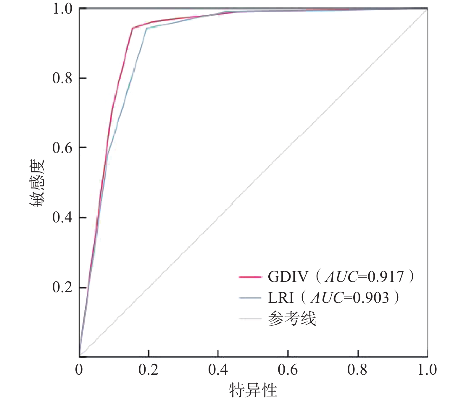
基于ROC曲线对GDIV模型和LRI模型滑坡危险性评价结果进行精度验证和对比分析。研究区共分布滑坡点313处,在研究区生成313处随机点作为非灾害样本点合并绘制ROC曲线(图6)。LRI模型的AUC值为0.903,标准误差为0.013,在满足显著性条件下AUC值最高可大0.929。GDIV模型的AUC值为0.917,标准误差为0.012,在满足显著性条件下AUC值最高可大0.941。两种模型的评价效果均较好,但GDIV模型的评价精度相对较高。由此表明基于GDIV模型的滑坡危险性评价方法在大渡河中游地区的实用性更好,能较好地评估滑坡危险情况。
4. 结论
本文以大渡河中游地区为研究区,初选高程、土壤类型和与河流距离等13个因子构建初级评价指标体系,利用地理探测器和信息量法实现因子的筛选和优化,构建GDIV模型开展研究区滑坡危险性评价,为验证模型的精度引入LRI模型,基于ROC曲线对比分析和验证两种模型的评价精度,得出以下结论。
(1)地理探测器结果表明,高程(q=0.583)和土壤类型(q=0.415)是区内滑坡危险性的重要背景因素,高程与工程地质岩组(q=0.736)、高程与地震动参数(q=0.676)、高程与年平均降雨量(q=0.672)的协同作用对滑坡的发生具有重要影响。
(2)基于GDIV模型的大渡河中游地区滑坡危险性评价结果显示,区内大部分地区为中度及以下危险区,面积占比为78.3%;而极高和高危险区面积占比为21.7%。极高危险区主要集中分布在河谷地区,工程地质岩组为松散土类均分布在该区内,土壤类型为淋溶土;高危险区要分布在东谷河、大渡河和革什扎河两侧极高危险区以外的区域;中危险区主要集中在海拔3200~4000 m范围内,极低和低危险区主要集中在人口稀少的高海拔区域。
(3)GDIV模型(AUC=0.917)评价精度高于LRI模型(AUC=0.903),在极高危险区和高危险区内GDIV模型所含滑坡点总量较LRI模型多7处。GDIV模型评价结果更符合区内滑坡分布情况,该模型适用于大渡河中游地区滑坡危险性评价。
-
![]()
图 1 大渡河中游地区滑坡分布图和地质条件背景图
Figure 1. Map of landslide distribution and geological conditions in the middle reach area of Dadu River
![]()
图 2 大渡河中游地区滑坡危险性初级评价指标体系分级图
Figure 2. Grading chart of the primary hazard assessment index system for landslides in the middle reach area of Dadu River Basin
表 1 交互作用探测器因子关系
Table 1 Factor relationships of interaction detectors
因子关系 交互作用 q(X1∩X2)<Min(q(X1), q(X2)) 非线性减弱 Min(q(X1), q(X2))< q(X1∩X2)< Max (q(X1), q(X2)) 单因子非线性减弱 q(X1∩X2)> Max (q(X1), q(X2)) 双因子增强 q(X1∩X2)= q(X1)+q(X2) 独立 q(X1∩X2)> q(X1)+q(X2) 非线性增强  下载: 导出CSV
表 2 滑坡初级评价指标q值统计
Table 2 Statistical analysis of primary evaluation index q-values for landslides
类别 指标 q值 p值 地质特征 工程地质岩组(X1) 0.156 0.000 与断层距离(X2) 0.087 0.000 地震 地震动参数(X3) 0.164 0.000 地形地貌 高程(X4) 0.583 0.000 坡度(X5) 0.021 0.023 坡向(X6) 0.038 0.003 地形湿度指数(X7) 0.017 0.297 归一化植被指数(X8) 0.072 0.000 土壤类型(X9) 0.415 0.000 地表水系 与河流距离(X10) 0.158 0.000 径流强度指数(X11) 0.032 0.015 降雨 年平均降雨量(X12) 0.182 0.000 人类活动 与道路距离(X13) 0.115 0.000
下载: 导出CSV
表 3 部分滑坡初级评价指标交互作用
Table 3 Interactions of primary evaluation indicators for landslides
Xi∩Xj q(Xi) q(Xj) q(Xi∩Xj) q(Xi)+q(Xj) 交互类型 X4∩X1 0.583 0.156 0.736 0.739 双因子增强 X3∩X4 0.164 0.583 0.676 0.747 双因子增强 X9∩X4 0.415 0.583 0.596 0.998 双因子增强 X10∩X4 0.158 0.583 0.603 0.741 双因子增强 X13∩X4 0.115 0.583 0.597 0.698 双因子增强 X12∩X4 0.182 0.583 0.672 0.765 双因子增强 X9∩X3 0.415 0.164 0.537 0.579 双因子增强 X9∩X1 0.415 0.156 0.555 0.571 双因子增强 X9∩X10 0.415 0.158 0.434 0.573 双因子增强 X9∩X13 0.415 0.115 0.428 0.53 双因子增强 X9∩X12 0.415 0.182 0.527 0.597 双因子增强 X10∩X3 0.158 0.164 0.312 0.322 双因子增强 X10∩X1 0.158 0.156 0.344 0.314 非线性增强 X13∩X3 0.115 0.164 0.276 0.279 双因子增强 X13∩X1 0.115 0.156 0.278 0.271 非线性增强 X3∩X1 0.164 0.156 0.329 0.320 非线性增强 X13∩X10 0.115 0.158 0.226 0.273 双因子增强 X10∩X12 0.158 0.182 0.343 0.340 非线性增强 X13∩X12 0.115 0.182 0.292 0.297 双因子增强 X3∩X12 0.164 0.182 0.269 0.346 双因子增强 X12∩X1 0.182 0.156 0.348 0.338 非线性增强
下载: 导出CSV
表 4 危险性评价因子分级与信息量值
Table 4 Grading and information value of hazard evaluation factors
评价因子 分级 信息量值 评价因子 分级 信息量值 高程/m <2 700 2.058 年平均
降雨量/mm<750 −0.557 2 700~3 200 1.308 750~775 0.438 3 200~3 600 −1.37 775~800 −1.014 3 600~4 000 −2.445 800~840 −0.055 4 000~4 400 −3.76 840~880 −0.404 > 4400 — >880 −0.231 土壤类型 淋溶土 1.685 地震动
参数<0.1 0.151 半淋溶土 — 0.1~0.15 0.464 初育土 −3.921 0.15~0.2 −1.059 高山土 0.107 0.2~0.3 — 人为土 1.429 与道路
距离/m<100 1.500 铁铝土 0.890 100~200 1.227 与河流
距离/m<400 −1.204 200~300 1.148 400~800 −0.826 300~400 1.053 800~1 200 −0.025 400~500 0.789 1 200~1 600 0.004 >500 −0.335 1 600~2 000 0.577 >2 000 1.038 工程地质
岩组坚硬岩 0.023 较坚硬岩 0.443 较软岩 1.878 松散土类 −1.086
下载: 导出CSV
表 5 滑坡危险性评价因子逻辑回归分析结果
Table 5 Results of logistic regression analysis for landslide hazard evaluation factors
评价因子 B SE Wald df sig Exp(B) 高程 4.992 0.551 82.210 1 0.000 147.24 土壤类型 3.001 0.550 29.785 1 0.000 20.110 工程地质岩组 1.606 0.837 3.387 1 0.000 4.666 年平均降雨量 1.103 0.379 8.468 1 0.000 3.013 与道路距离 0.995 0.396 2.573 1 0.000 2.435 地震动参数 0.802 0.469 1.657 1 0.000 1.830 与河流距离 0.148 0.398 5.259 1 0.001 0.739 常数 −7.132 0.696 104.815 1 0.000 0.001 注:B为模型中各变量的回归系数、SE是标准差、Wald是卡方统计、Sig为显著性水平,df和Exp(B)为逻辑回归的结果参数。
下载: 导出CSV
表 6 滑坡危险性评价因子权重值
Table 6 Weight values of landslide hazard assessment factors
因子 q值 权重 高程 0.583 0.329 土壤类型 0.415 0.234 年平均降雨量 0.182 0.103 地震动参数 0.164 0.092 与河流距离 0.158 0.089 工程地质岩组 0.156 0.088 与道路距离 0.115 0.065
下载: 导出CSV
-
[1] 赵东亮,兰措卓玛,侯光良,等. 青海省河湟谷地地质灾害易发性评价[J]. 地质力学学报,2021,27(1):83 − 95. [ZHAO Dongliang,LAN C,HOU Guangliang,et al. Assessment of geological disaster susceptibility in the Hehuang Valley of Qinghai Province[J]. Journal of Geomechanics,2021,27(1):83 − 95. (in Chinese with English abstract) ZHAO Dongliang, LAN C, HOU Guangliang, et al. Assessment of geological disaster susceptibility in the Hehuang Valley of Qinghai Province[J]. Journal of Geomechanics, 2021, 27(1): 83-95. (in Chinese with English abstract)
[2] CENGIZ L D,ERCANOGLU M. A novel data-driven approach to pairwise comparisons in AHP using fuzzy relations and matrices for landslide susceptibility assessments[J]. Environmental Earth Sciences,2022,81(7):1 − 23.
[3] WANG Di,HAO Mengmeng,CHEN Shuai,et al. Assessment of landslide susceptibility and risk factors in China[J]. Natural Hazards,2021,108(3):3045 − 3059. DOI: 10.1007/s11069-021-04812-8
[4] TAN Qulin,BAI Minzhou,ZHOU Pinggen,et al. Geological hazard risk assessment of line landslide based on remotely sensed data and GIS[J]. Measurement,2021,169:108370. DOI: 10.1016/j.measurement.2020.108370
[5] BIÇER Ç T,ERCANOGLU M. A semi-quantitative landslide risk assessment of central Kahramanmaraş City in the Eastern Mediterranean region of Turkey[J]. Arabian Journal of Geosciences,2020,13(15):732. DOI: 10.1007/s12517-020-05697-w
[6] SCIARRA M,COCO L,URBANO T. Assessment and validation of GIS-based landslide susceptibility maps:A case study from Feltrino stream basin (Central Italy)[J]. Bulletin of Engineering Geology and the Environment,2017,76(2):437 − 456. DOI: 10.1007/s10064-016-0954-7
[7] 罗守敬,王珊珊,付德荃. 北京山区突发性地质灾害易发性评价[J]. 中国地质灾害与防治学报,2021,32(4):126 − 133. [LUO Shoujing,WANG Shanshan,FU Dequan. Assessment on the susceptibility of sudden geological hazards in mountainous areas of Beijing[J]. The Chinese Journal of Geological Hazard and Control,2021,32(4):126 − 133. (in Chinese with English abstract) LUO Shoujing, WANG Shanshan, FU Dequan. Assessment on the susceptibility of sudden geological hazards in mountainous areas of Beijing[J]. The Chinese Journal of Geological Hazard and Control, 2021, 32(4): 126-133. (in Chinese with English abstract)
[8] ZHAO Fumeng,MENG Xingmin,ZHANG Yi,et al. Landslide susceptibility mapping of Karakorum highway combined with the application of SBAS-InSAR technology[J]. Sensors,2019,19(12):2685. DOI: 10.3390/s19122685
[9] 王世宝,庄建琦,樊宏宇,等. 基于频率比与集成学习的滑坡易发性评价—以金沙江上游巴塘—德格河段为例[J]. 工程地质学报,2022,30(3):817 − 828. [WANG Shibao,ZHUANG Jianqi,FAN Hongyu,et al. Evaluation of landslide susceptibility based on frequency ratio and ensemble learning:Taking the Batang-Dege section in the upstream of Jinsha River as an example[J]. Journal of Engineering Geology,2022,30(3):817 − 828. (in Chinese with English abstract) WANG Shibao, ZHUANG Jianqi, FAN Hongyu, et al. Evaluation of landslide susceptibility based on frequency ratio and ensemble learning—taking the Batang-Dege section in the upstream of Jinsha River as an example[J]. Journal of Engineering Geology, 2022, 30(3): 817-828. (in Chinese with English abstract)
[10] 屠水云,张钟远,付弘流,等. 基于CF与CF-LR模型的地质灾害易发性评价[J]. 中国地质灾害与防治学报,2022,33(2):96 − 104. [TU Shuiyun,ZHANG Zhongyuan,FU Hongliu,et al. Geological hazard susceptibility evaluation based on CF and CF-LR model[J]. The Chinese Journal of Geological Hazard and Control,2022,33(2):96 − 104. (in Chinese with English abstract) TU Shuiyun, ZHANG Zhongyuan, FU Hongliu, et al. Geological hazard susceptibility evaluation based on CF and CF-LR model[J]. The Chinese Journal of Geological Hazard and Control, 2022, 33(2): 96-104. (in Chinese with English abstract)
[11] JIAO Yuanmei,ZHAO Dongmei,DING Yinping,et al. Performance evaluation for four GIS-based models purposed to predict and map landslide susceptibility:A case study at a World Heritage site in Southwest China[J]. CATENA,2019,183:104221. DOI: 10.1016/j.catena.2019.104221
[12] 罗路广,裴向军,谷虎,等. 基于GIS的 “8·8” 九寨沟地震景区地质灾害风险评价[J]. 自然灾害学报,2020,29(3):193 − 202. [LUO Luguang,PEI Xiangjun,GU Hu,et al. Risk assessment of geohazards induced by “8·8” earthquake based on GIS in Jiuzhaigou scenic area[J]. Journal of Natural Disasters,2020,29(3):193 − 202. (in Chinese with English abstract) LUO Luguang, PEI Xiangjun, GU Hu, et al. Risk assessment of geohazards induced by “8.8” earthquake based on GIS in Jiuzhaigou scenic area[J]. Journal of Natural Disasters, 2020, 29(3)193-202(in Chinese with English abstract)
[13] 付树林,梁丽萍,刘延国. 基于CF-Logistic模型的雅砻江新龙段地质灾害易发性评价[J]. 水土保持研究,2021,28(4):404 − 410. [FU Shulin,LIANG Liping,LIU Yanguo. Assessment on geohazard susceptibility in Xinlong section of Yalong River based on CF-logistic model[J]. Research of Soil and Water Conservation,2021,28(4):404 − 410. (in Chinese with English abstract) FU Shulin, LIANG Liping, LIU Yanguo. Assessment on geohazard susceptibility in Xinlong section of yalong river based on CF-logistic model[J]. Research of Soil and Water Conservation, 2021, 28(4)404-410(in Chinese with English abstract)
[14] DUMAN T Y,CAN T,GOKCEOGLU C,et al. Application of logistic regression for landslide susceptibility zoning of Cekmece Area,Istanbul,Turkey[J]. Environmental Geology,2006,51(2):241 − 256. DOI: 10.1007/s00254-006-0322-1
[15] 胡涛,樊鑫,王硕,等. 基于逻辑回归模型和3S技术的思南县滑坡易发性评价[J]. 地质科技通报,2020(2):113 − 121. [HU Tao,FAN Xin,WANG Shuo,et al. Landslide susceptibility evaluation of Sinan County using logistics regression model and 3S technology[J]. Geological Science and Technology Information,2020(2):113 − 121. (in Chinese with English abstract) HU Tao, FAN Xin, WANG Shuo, et al. Landslide susceptibility evaluation of Sinan County using logistics regression model and 3S technology[J]. Geological Science and Technology Information, 2020(2): 113-121. (in Chinese with English abstract)
[16] 田春山,刘希林,汪佳. 基于CF和Logistic回归模型的广东省地质灾害易发性评价[J]. 水文地质工程地质,2016,43(6):154 − 161. [TIAN Chunshan,LIU Xilin,WANG Jia. Geohazard susceptibility assessment based on CF model and Logistic Regression models in Guangdong[J]. Hydrogeology & Engineering Geology,2016,43(6):154 − 161. (in Chinese with English abstract) TIAN Chunshan, LIU Xilin, WANG Jia. Geohazard susceptibility assessment based on CF model and Logistic Regression models in Guangdong[J]. Hydrogeology and Engineering Geology, 2016, 43(6)154-161(in Chinese with English abstract)
[17] 饶品增,曹冉,蒋卫国. 基于地理加权回归模型的云南省地质灾害易发性评价[J]. 自然灾害学报,2017,26(2):134 − 143. [RAO Pinzeng,CAO Ran,JIANG Weiguo. Susceptibility evaluation of geological disasters in Yunnan Province based on geographically weighted regression model[J]. Journal of Natural Disasters,2017,26(2):134 − 143. (in Chinese with English abstract) Rao Pinzeng, Cao Ran, Jiang Weiguo. Susceptibility evaluation of geological disasters in Yunnan Province based on geographically weighted regression model[J]. Journal of Natural Disasters, 2017, 26(2): 134-143. (in Chinese with English abstract)
[18] 王丽丽,苏程,冯存均,等. 数据驱动自适应更新的斜坡地质灾害易发性评价系统[J]. 岩石力学与工程学报,2016,35(S1):3076 − 3083. [WANG Lili,SU Cheng,FENG Cunjun,et al. A data driven self-adaptive update landslide susceptibility assessment system[J]. Chinese Journal of Rock Mechanics and Engineering,2016,35(S1):3076 − 3083. (in Chinese with English abstract) WANG Lili, SU Cheng, FENG Cunjun, et al. A data driven self-adaptive update landslide susceptibility assessment system[J]. Chinese Journal of Rock Mechanics and Engineering, 2016, 35(S1): 3076-3083. (in Chinese with English abstract)
[19] 黄发明,殷坤龙,蒋水华,等. 基于聚类分析和支持向量机的滑坡易发性评价[J]. 岩石力学与工程学报,2018,37(1):12 − 167. [HUANG Faming,YIN Kunlong,JIANG Shuihua,et al. Landslide susceptibility assessment based on clustering analysis and support vector machine[J]. Chinese Journal of Rock Mechanics and Engineering,2018,37(1):12 − 167. (in Chinese with English abstract) Huang Faming, Yin Kunlong, Jiang Shuihua, et al. Landslide susceptibility assessment based on clustering analysis and support vector machine[J]. Chinese Journal of Rock Mechanics and Engineering, 2018, 37(1): 12. (in Chinese with English abstract)
[20] 吴润泽,胡旭东,梅红波,等. 基于随机森林的滑坡空间易发性评价—以三峡库区湖北段为例[J]. 地球科学,2021(1):321 − 330. [WU Runze,HU Xudong,MEI Hongbo,et al. Spatial susceptibility assessment of landslides based on random forest:A case study from Hubei section in the Three Gorges Reservoir area[J]. Earth Science,2021(1):321 − 330. (in Chinese with English abstract) WU Runze, HU Xudong, MEI Hongbo, et al. Spatial susceptibility assessment of landslides based on random forest: a case study from Hubei section in the Three Gorges Reservoir area[J]. Earth Science, 2021(1): 321-330. (in Chinese with English abstract)
[21] 丁茜,赵晓东,吴鑫俊,等. 基于RBF核的多分类SVM滑塌易发性评价模型[J]. 中国安全科学学报,2022,32(3):194 − 200. [DING Xi,ZHAO Xiaodong,WU Xinjun,et al. Landslide susceptibility assessment model based on multi-class SVM with RBF kernel[J]. China Safety Science Journal,2022,32(3):194 − 200. (in Chinese with English abstract) DING Xi, ZHAO Xiaodong, WU Xinjun, et al. Landslide susceptibility assessment model based on multi-class SVM with RBF kernel[J]. China Safety Science Journal, 2022, 32(3): 194-200. (in Chinese with English abstract)
[22] 唐川,马国超. 基于地貌单元的小区域地质灾害易发性分区方法研究[J]. 地理科学,2015(1):91 − 98. [TANG Chuan,MA Guochao. Small regional geohazards susceptibility mapping based on geomorphic unit[J]. Scientia Geographica Sinica,2015(1):91 − 98. (in Chinese with English abstract) Tang Chuan, Ma Guochao. Small regional geohazards susceptibility mapping based on geomorphic unit[J]. Scientia Geographica Sinica, 2015(1): 91-98. (in Chinese with English abstract)
[23] WANG Fei,XU Peihua,WANG Changming,et al. Application of a GIS-based slope unit method for landslide susceptibility mapping along the Longzi River,southeastern Tibetan Plateau,China[J]. ISPRS International Journal of Geo-Information,2017,6(6):172. DOI: 10.3390/ijgi6060172
[24] 陈前,晏鄂川,黄少平,等. 基于样本与因子优化的黄冈南部地区地质灾害易发性评价[J]. 地质科技通报,2020(2):175 − 185. [CHEN Qian,YAN Echuan,HUANG Shaoping,et al. Susceptibility evaluation of geological disasters in southern Huanggang based on samples and factor optimization[J]. Geological Science and Technology Information,2020(2):175 − 185. (in Chinese with English abstract) CHEN Qian, YAN Echuan, HUANG Shaoping, et al. Susceptibility evaluation of geological disasters in southern Huanggang based on samples and factor optimization[J]. Geological Science and Technology Information, 2020(2): 175-185. (in Chinese with English abstract)
[25] 陈绪钰,倪化勇,李明辉,等. 基于加权信息量和迭代自组织聚类的地质灾害易发性评价[J]. 灾害学,2021,36(2):71 − 78. [CHEN Xuyu,NI Huayong,LI Minghui,et al. Geo-hazard susceptibility evaluation based on weighted information value model and ISODATA cluster[J]. Journal of Catastrophology,2021,36(2):71 − 78. (in Chinese with English abstract) CHEN Xuyu, NI Huayong, LI Minghui, et al. Geo-hazard susceptibility evaluation based on weighted information value model and ISODATA cluster[J]. Journal of Catastrophology, 2021, 36(2): 71-78. (in Chinese with English abstract)
[26] 牛强,揭巧,李县. 变权栅格叠加方法研究—以生态敏感性评价为例[J]. 地理信息世界,2017,24(5):27 − 34. [NIU Qiang, JIE Qiao,LI Xian. Research on variable weight raster overlay-taking ecological sensitivity evaluation as an example[J]. Geomatics World,2017,24(5):27 − 34. (in Chinese with English abstract) QIANG niu, QIAO Jie, XIAN Li. Research on variable weight raster overlay-taking ecological sensitivity evaluation as an example[J]. Geomatics World, 2017, 24(5): 27-34. (in Chinese with English abstract)
[27] 韩用顺,孙湘艳,刘通,等. 基于证据权-投影寻踪模型的藏东南地质灾害易发性评价[J]. 山地学报,2021,39(5):672 − 686. [HAN Yongshun,SUN Xiangyan,LIU Tong,et al. Susceptibility evaluation of geological hazards based on evidence weight-projection pursuit model in southeast Tibet,China[J]. Mountain Research,2021,39(5):672 − 686. (in Chinese with English abstract) HAN Yongshun, SUN Xiangyan, LIU Tong, et al. Susceptibility evaluation of geological hazards based on evidence weight-projection pursuit model in southeast Tibet, China[J]. Mountain Research, 2021, 39(5): 672-686. (in Chinese with English abstract)
[28] 支泽民, 刘峰贵, 周强, 等. 基于流域单元的地质灾害易发性评价—以西藏昌都市为例[J]. 中国地质灾害与防治学报,2023,34(1):139 − 150. [ZHI Zemin, LIU Fenggui, ZHOU Qiang, et al. Evaluation of geological hazards susceptibility based on watershed units:A case study of the Changdu City, Tibet[J]. The Chinese Journal of Geological Hazard and Control,2023,34(1):139 − 150. (in Chinese with English abstract) ZHI Zemin, LIU Fenggui, ZHOU Qiang, et al. Evaluation of geological hazards susceptibility based on watershed units: a case study of the Changdu City, Tibet[J]. The Chinese Journal of Geological Hazard and Control, 2023, 34(1): 139-150.(in Chinese with English abstract)
[29] YANG Yanguo,YU Jiaqi,FU Yubin,et al. Research on geological hazard risk assessment based on the cloud fuzzy clustering algorithm[J]. Journal of Intelligent & Fuzzy Systems,2019,37(4):4763 − 4770.
[30] 孙滨, 祝传兵, 康晓波, 等. 基于信息量模型的云南东川泥石流易发性评价[J]. 中国地质灾害与防治学报,2022,33(5):119 − 127. [SUN Bin, ZHU Chuanbing, KANG Xiaobo, et al. Susceptibility assessment of debris flows based on information model in Dongchuan, Yunnan Province[J]. The Chinese Journal of Geological Hazard and Control,2022,33(5):119 − 127. (in Chinese with English abstract) SUN Bin, ZHU Chuanbing, KANG Xiaobo, et al. Susceptibility assessment of debris flows based on information model in Dongchuan, Yunnan Province[J]. The Chinese Journal of Geological Hazard and Control, 2022, 33(5)119-127(in Chinese with English abstract)
[31] 王劲峰,徐成东. 地理探测器:原理与展望[J]. 地理学报,2017,72(1):116 − 134. [WANG Jinfeng,XU Chengdong. Geodetector:Principle and prospective[J]. Acta Geographica Sinica,2017,72(1):116 − 134. (in Chinese with English abstract) WANG Jinfeng, XU Chengdong. Geodetector: principle and prospective[J]. Acta Geographica Sinica, 2017, 72(1)116-134(in Chinese with English abstract)
[32] LUO Wei,LIU C C. Innovative landslide susceptibility mapping supported by geomorphon and geographical detector methods[J]. Landslides,2018,15(3):465 − 474. DOI: 10.1007/s10346-017-0893-9
[33] 韩继冲,张朝,曹娟. 基于逻辑回归的地震滑坡易发性评价—以汶川地震、鲁甸地震为例[J]. 灾害学,2021,36(2):193 − 199. [HAN Jichong,ZHANG Hao,CAO Juan. Assessing earthquake-induced landslide susceptibility based on logistic regression in 2008 Wenchuan earthquake and 2014 Ludian earthquake[J]. Journal of Catastrophology,2021,36(2):193 − 199. (in Chinese with English abstract) HAN Jichong, ZHANG Hao, CAO Juan. Assessing earthquake-induced landslide susceptibility based on logistic regression in 2008 Wenchuan earthquake and 2014 Ludian earthquake[J]. Journal of Catastrophology, 2021, 36(2): 193-199. (in Chinese with English abstract)
-
期刊类型引用(4)
1. 龚学强,席传杰,胡卸文,胡亚运,周永豪,张瑜. 考虑负样本取样策略的滑坡易发性评价与区划——以四川省巴中地区为例. 中国地质灾害与防治学报. 2025(01): 146-155 .  本站查看
本站查看
2. 殷玮民,李远耀,李星,李明,居乐,谢藕. 考虑岩土体物理力学参数空间校准分区的滑坡危险性评价. 中国地质灾害与防治学报. 2025(02): 162-174 . 本站查看
3. 曾韬睿,王林峰,张俞,程平,吴帆. 基于CatBoost-SHAP模型的滑坡易发性建模及可解释性. 中国地质灾害与防治学报. 2024(01): 37-50 . 本站查看
4. 宋德光,吴瑞安,马德芹,郭长宝,王炀,倪嘉伟,李祥. 四川泸定昔格达组滑坡灾害运动过程模拟分析. 地质通报. 2023(12): 2185-2197 . 百度学术
其他类型引用(0)


计量
- 文章访问数: 901
- HTML全文浏览量: 211
- PDF下载量: 121
- 被引次数: 4
 邮件订阅
邮件订阅 RSS
RSS