

Risk assessment of geological hazards in Song County, Henan Province
-
摘要: 基于ArcGIS环境下,通过选取河南省嵩县区域高程、地貌、工程岩组、植被覆盖度、距构造距离、距水系距离、坡度、坡向等 8个因子建立危险性评价模型,易损性选取建筑物、人员和交通等 3 个承灾因子,分别采用信息量模型和层次分析法对河南省嵩县区域进行地质灾害易发性、危险性和易损性评价。研究结果表明,嵩县区域划分为低风险区面积为965.34 km2,占嵩县区域面积32%;中风险区面积为1114.65 km2,占嵩县区域面积的37%;高风险区面积为826.23 km2,占嵩县区域面积的27%;极高风险区面积为102.68 km2,占嵩县区域面积的3%。研究成果可应用于嵩县防灾减灾及地质灾害风险管控等方面。Abstract: Using the ArcGIS environment, a risk assessment model is established by selecting eight indicator factors, including regional elevation, landform, engineering rock group, vegetation coverage, distance from structures, distance from water systems, slope, and slope direction in Song county, Henan Province, China. The vulnerability is evaluated under three disaster-bearing factors: buildings, personnel and traffic. The information volume model and analytic hierarchy process are used to assess the susceptibility, risk and vulnerability of geological disasters in Song county. The results show that the area of Song county is divided into low-risk areas, covering 965.34 km2, accounting for 32% of the total area; medium risk area, covering 1114.65 km2, accounting for 37% of the total area; high-risk area, covering 826.23 km2, accounting for 27% of the total area; and extremely high risk area, covering 102.68 km2, accounting for 3% of the area. These research findings can be widely applied to disaster prevention, mitigation, and geological disaster risk control in Song county.
-
Keywords:
- ArcGIS /
- Song County, Henan Province /
- geologic hazard /
- risk assessment
-
0. 引言
地质灾害风险评价主要包含地质灾害易发性评价、危险性评价和易损性评价等内容,综合评价、预测地质灾害发生的可能性大小,是一门自然属性和社会属性并重的交叉学科[1]。
地质灾害风险的概念最早由国外学者 Varnes提出,国外诸多学者对地质灾害风险评价进行了研究[2-7]。近年来,国内很多学者对基于ArcGIS的地质灾害风险评价进行了研究[8-14],建立了地灾风险评估体系和评价模式[15-20]。
随着全球气温上升,降雨量呈逐年增大趋势,近年来河南省嵩县白河镇、闫庄镇、纸房镇、何村乡、饭坡镇等乡镇先后发生10余起地质灾害,见图1(c),其中小型滑坡6起,小型崩塌4起。多期地质灾害造成2人死亡,12间房屋受损,直接经济损失达70余万元,见图1(c)。政府对嵩县地质灾害防治高度重视,在 2021年度中央自然灾害防治体系建设补助资金的资助下,2021—2022年河南省第一地质矿产调查院有限公司开展了《河南省嵩县1∶5万地质灾害风险调查(普查)评价》工作,项目研究成果对嵩县城市规划、防灾减灾及地质灾害风险管控方面具有积极的意义。
1. 研究区概况及数据来源
1.1 自然地理及地质条件
嵩县位于洛阳市西南部伏牛山区,境内有河谷、丘陵、低山、中山等多种地貌形态。海拔高度自田湖镇千秋外河滩的245 m递增至白河乡白云山玉皇顶的2211.6 m,高差达1966.6 m。区内从新到老出露地层主要为第四系、中新统洛阳组、下白垩统九店组、下古生界二郎坪群、上元古界栾川群、中~上元古界宽坪群、中元古界熊耳群鸡蛋坪组、中元古界熊耳群马家河组—鸡蛋坪组并层、太古界太华群、花岗岩等。区内主要断裂:北西西向断裂主要为黑沟—陶湾断裂带F6、马超营断裂带F4和瓦穴子断裂F7,东西向断裂主要为车村南—下汤大断裂F5,北东向断裂主要为蝉堂—汝阳断裂带F3、旧县—下蛮峪断裂带F2和温家村—朝阳断裂带F1(图2)。
![]() 图 2 研究区地质构造简图1—第四系;2—中新统洛阳组;3—下白垩统九店组;4—下古生界二郎坪群;5—上元古界栾川群;6—中—上元古界宽坪群;7—中元古界熊耳群鸡蛋坪组;8—中元古界熊耳群马家河组-鸡蛋坪组并层;9—太古界太华群;10—花岗岩;11—陆浑水库;12—正断层及编号;13—逆断层及编号;14—性质不明断层;15—乡界;16—县界;17—县政府所在地;18—镇(乡)政府所在地Figure 2. Geological structure sketch map of the study area
图 2 研究区地质构造简图1—第四系;2—中新统洛阳组;3—下白垩统九店组;4—下古生界二郎坪群;5—上元古界栾川群;6—中—上元古界宽坪群;7—中元古界熊耳群鸡蛋坪组;8—中元古界熊耳群马家河组-鸡蛋坪组并层;9—太古界太华群;10—花岗岩;11—陆浑水库;12—正断层及编号;13—逆断层及编号;14—性质不明断层;15—乡界;16—县界;17—县政府所在地;18—镇(乡)政府所在地Figure 2. Geological structure sketch map of the study area1.2 经济条件概况
嵩县下辖16个乡镇,总人口54.3万,嵩县为山区大县,全县总面积约3008.9 km,嵩县森林覆盖率65.18%,荣获“国家生态示范县”和“全国造林绿化百佳县”。嵩县已探明各类矿产46种,其中黄金储量372 t,年产黄金近20 t,列全省第二,全国第五;钼矿石储量6.8×10⁸ t,年产钼精粉2285 t;铁、萤石、铅、锌、银等有良好的找矿前景。嵩县大力实施“生态立县、工业强县、旅游带动、民生为本”四大战略,经济社会发展取得了一定成效。
1.3 数据来源
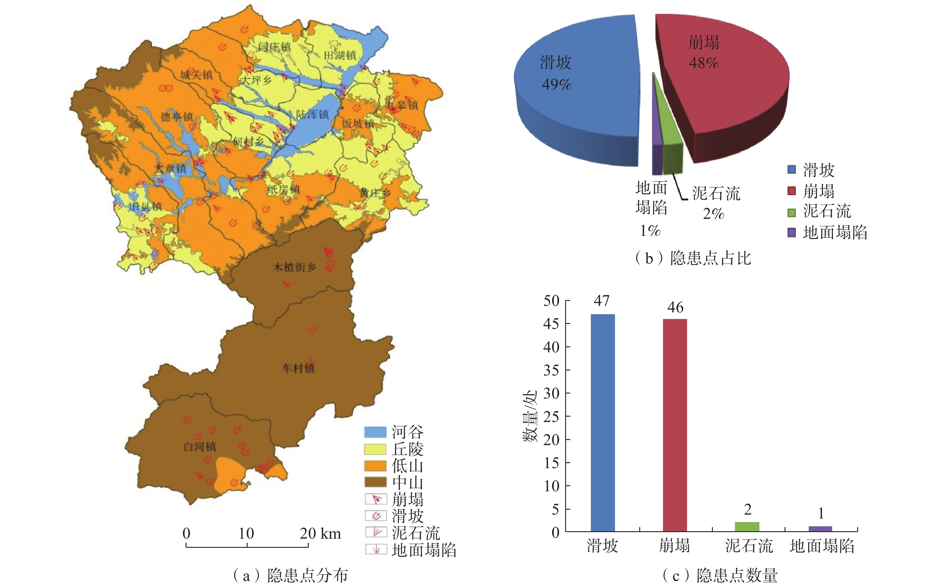
本文数据主要来源于《河南省嵩县1∶5万地质灾害风险调查(普查)评价》项目,项目数据通过资料收集、野外现场调查、遥感解译(哨兵-1系列C波段雷达卫星数据、高分-2号高空间分辨率卫星数据)、室内资料整理与综合研究等多种工作手段获取。在嵩县全境共查明地质灾害隐患点96处,全县16个乡镇均存在有地质灾害隐患,主要为滑坡和崩塌,地质灾害隐患点分布详见图3。
![]() 图 3 嵩县地质灾害隐患点分布图Figure 3. Distribution map of geological hazard potential sites in Song county
图 3 嵩县地质灾害隐患点分布图Figure 3. Distribution map of geological hazard potential sites in Song county2. 地质灾害易发性评价
2.1 信息量模型
信息量模型是从信息预测发展而来的一种评价预测方法[8],是基于ArcGIS环境下,由信息量值来作为该单元影响地质灾害危险性的综合指标,其值越大越容易发生地质灾害,该单元的地质灾害易发性就越高,计算公式如下[9-10]:
(1) 式中:
N——研究区有地质灾害总面积/km2;
S——研究区总面积/km2;
n——评价体系中参评因子总数/km2。
2.2 评价因子的选取与分级
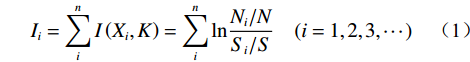
通过对研究区地质灾害与孕灾环境因素的分析,选择高程、地貌、工程岩组、植被覆盖度、距构造距离、距水系距离、坡度、坡向等 8个因子进行地质灾害易发性评价。高程、坡度、坡向因子由 25 m × 25 m DEM 数据提取;地貌、工程岩组因子由 1∶5 万区域地质图获取;距水系距离、距构造距离因子利用ArcGIS缓冲区分析计算提取;植被覆盖度利用两景Landsat8影像,采用归一化植被指数(NDVI)对其进行计算提取。对 8个评价因子进行分级,并根据式(1) 计算信息量值,结果见表1。
表 1 易发性评价因子分级及信息量值Table 1. Classification and information value of susceptibility assessment factors评价因子 指标分级 Ni/N Si/S 信息量值 高程/m [0, 500] 0.3800 0.2146 0.5715 [500, 1000) 0.5800 0.5620 0.0316 [1000, 1500) 0.0400 0.1952 −1.5854 ≥1500 0.0000 0.0282 0.0000 地貌 河谷 0.0558 0.0609 −0.0883 中山 0.2988 0.3985 −0.2879 低山 0.3183 0.3176 0.0037 丘陵 0.3267 0.2230 0.3817 工程岩组 坚硬花岗岩岩组 0.1520 0.3001 −0.6803 坚硬片麻岩岩组 0.0280 0.0563 −0.6992 软弱黏性土岩组 0.1000 0.0881 0.1268 较软弱砾岩岩组 0.0360 0.0164 0.7832 较坚硬砂岩页岩互层岩组 0.0160 0.0113 0.3452 较软弱砂质砾岩岩组 0.1880 0.1178 0.4674 坚硬安山岩类岩组 0.3080 0.3421 −0.1049 较软弱石英云母片岩岩组 0.1520 0.0455 1.2065 较坚硬硅质板岩岩组 0.0120 0.0145 −0.1910 较软弱页岩岩组 0.0040 0.0021 0.6393 较坚硬灰岩岩组 0.0040 0.0057 −0.3503 植被覆盖度 [0, 0.5) 0.1004 0.0553 0.5967 [0.5, 0.65) 0.5100 0.2945 0.5493 [0.65, 0.75) 0.3133 0.3799 −0.1928 [0.75, 1] 0.0763 0.2704 −1.2651 距构造距离/m [0, 500) 0.5000 0.3065 0.4892 [500, 1000) 0.1960 0.1905 0.0286 [1000, 1500) 0.1320 0.1241 0.0616 [1500, 2000) 0.0480 0.0903 −0.6318 ≥2000 0.1240 0.2886 −0.8446 距水系距离/m [0, 500) 0.7800 0.5490 0.3512 [500, 1000) 0.1200 0.2563 −0.7588 [1000, 1500) 0.0600 0.1101 −0.6069 [1500, 2000) 0.0240 0.0415 −0.5476 ≥2000 0.0160 0.0431 −0.9919 坡度/(°) [0, 10) 0.0680 0.1321 −0.6637 [10, 25) 0.3200 0.2117 0.4133 [25, 40) 0.2960 0.2936 0.0082 ≥40 0.3160 0.3627 −0.1378 坡向/(°) FLAT(−1) 0.0000 0.0106 0.0000 N[337.5, 22.5) 0.0680 0.1427 −0.7415 NE[22.5, 67.5) 0.1480 0.1352 0.0903 E[67.5, 112.5) 0.1360 0.1130 0.1856 SE[112.5, 157.5) 0.1720 0.1164 0.3901 S[157.5, 202.5) 0.2160 0.1630 0.2814 SW[202.5, 247.5) 0.1240 0.1236 0.0032 W[247.5, 292.5) 0.0840 0.0922 −0.0928 NW[292.5, 337.5) 0.0520 0.1033 −0.6862 2.3 评价结果分析
由表1 可知,地质灾害发育程度与距构造距离、植被覆盖度呈负相关,距构造距离越近、植被覆盖度越低地区地质灾害易发性越高;在丘陵地区及坡度在10°~25°地区,地质灾害易发性较高;坡向为东向、南东向、南向的边坡地质灾害易发性较高;地质灾害隐患主要分布在高程0~500 m内软弱地层中;河流水系对地质灾害的易发性,表现出一定的距离效应,距河流水系越近,地质灾害易发性越高。
在ArcGIS 环境下,运用栅格计算器对各因子信息量值叠加计算出嵩县区域地质灾害易发性评价指数,在此基础上采用自然断点法将嵩县区域划分为非易发区、低易发区、中易发区、高易发区等4个区,得到地质灾害易发性分区图,见图4(a)。对地质灾害易发性评价结果进行统计见图4 (b)(c) ,结果表明:非易发区面积为638.45 km2,占整个嵩县区域面积的21.22%;低易发区面积为686.51 km2,占整个嵩县区域面积的22.82%;中易发区面积为1029.03 km2,占整个嵩县区域面积的34.21%;高易发区面积为654.14 km2 ,占整个嵩县区域面积的21.75%。
![]() 图 4 嵩县地质灾害易发性分区结果图Figure 4. Results of geological hazard susceptibility zoning in Song County
图 4 嵩县地质灾害易发性分区结果图Figure 4. Results of geological hazard susceptibility zoning in Song County3. 地质灾害危险性评价
地质灾害危险性分极高、高、中、低四个等级,地质灾害危险性评价区划的主要目的及用途就是为当地政府制定详细的土地利用提供决策依据。调查资料显示,嵩县全区地震活动相对较弱,地震烈度和地震动峰值加速度在区域内区别不大,因此本次危险性评价中未考虑地震活动的影响因素,参与危险性评价的主要诱发因素为降雨量。
3.1 评价过程
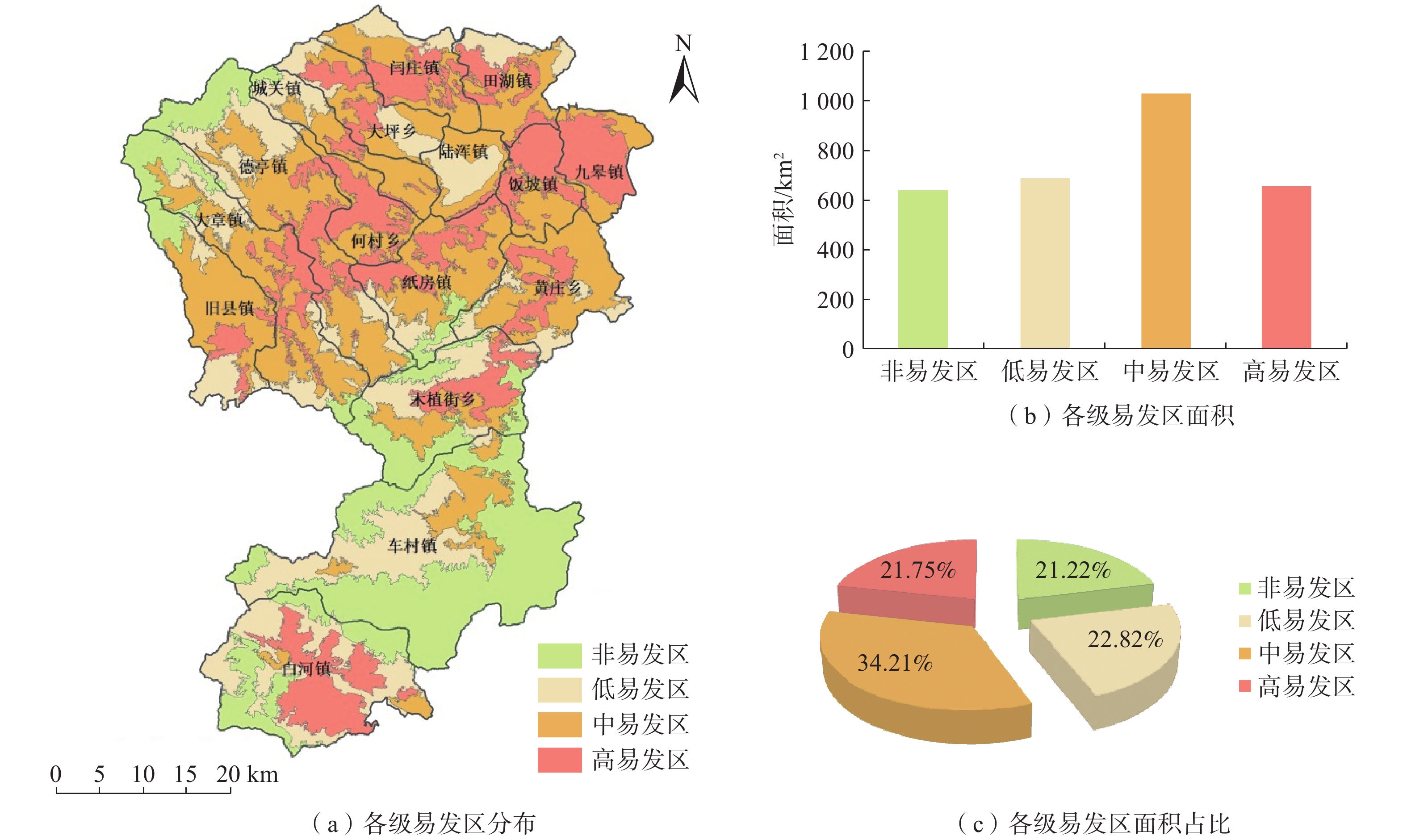
本区地震活动相对较弱,而且能够代表地震活动程度的地震烈度和地震动峰值加速度在区域内区别不大,因此本次危险性评价中未考虑地震活动的影响因素。本次嵩县区域地质灾害危险性评价主要考虑因素为降雨诱发因素。根据收集到的嵩县区内 17 个气象站点2014—2021年的降雨量数据(表2),计算月累计降雨量,并将其归一化处理(图5)。在ArcGIS 环境下,进行归一化处理,对降雨量线性变换,使得结果映射到0~1之间,计算方法为:
表 2 嵩县1992—2021年降雨量统计表Table 2. Statistical table of Rainfall level in Song county from 1992—2021年份 1992 1993 1994 1995 1996 1997 1998 1999 2000 2001 年降雨量/mm 576.90 675.20 529.60 470.70 959.10 418.10 773.10 589.90 760.30 433.10 月平均降雨量/mm 48.08 56.27 44.13 39.23 79.93 34.84 64.43 49.16 231.50 36.09 年份 2002 2003 2004 2005 2006 2007 2008 2009 2010 2011 年降雨量/mm 657.60 1067.40 690.90 718.40 636.70 565.10 558.80 764.30 924.00 931.50 月平均降雨量/mm 54.80 88.95 57.58 59.87 53.06 47.09 46.57 63.69 77.00 77.63 年份 2012 2013 2014 2015 2016 2017 2018 2019 2020 2021 年降雨量/mm 649.50 518.60 674.10 594.80 562.70 745.30 690.10 690.10 642.50 944.40 月平均降雨量/mm 54.13 43.22 56.18 49.57 46.89 62.11 57.51 53.26 53.54 145.29 ![]() 图 5 月累计降雨量归一化结果Figure 5. Normalized results of monthly cumulative rainfall in the study area
图 5 月累计降雨量归一化结果Figure 5. Normalized results of monthly cumulative rainfall in the study area(2) 式中:y——归一化值;
x——降雨值;
max(x)——降雨最大值;
min(x)——降雨最小值。
降雨量归一化结果与易发性归一化结果(图6)进行叠加,按自然断点法划分为极高、高、中和低危险 4 个等级,得到嵩县区域危险性评价图(图7)。
3.2 评价结果
在ArcGIS 环境下,将易发性归一化结果和2014—2021年月累计降雨量归一化结果叠加计算出嵩县区域地质灾害危险性评价指数,通过自然断点法划分为极高、高、中和低危险区等4个区,得到地质灾害危险性分区图,见图7(a)。对地质灾害危险性评价结果进行统计,见图7(b)(c),结果表明:低危险区面积为400.43 km2,占嵩县全区面积的13.31%;中危险区面积为1515.14 km2,占嵩县全区面积的50.36%;高危险区面积为910.38 km2,占嵩县全区面积的30.26%;极高危险区面积为182.95 km2,占嵩县全区面积的6.08%。
4. 风险区划
风险评价是一个综合过程,是将地质灾害危险性和易损性评价结果的集成运用。
4.1 易损性评价
本次易损性评价主要选取建筑物易损性、人员易损性和交通设施易损性等3个评价因子,以25 m×25 m栅格评价单元为基础,结合承载体易损性赋值表3,在ArcGIS环境下,计算各评价因子的易损性值,得到建筑物易损性、人员易损性和交通设施易损性等3个因子的分区图,见图8(a)(b)(c)。
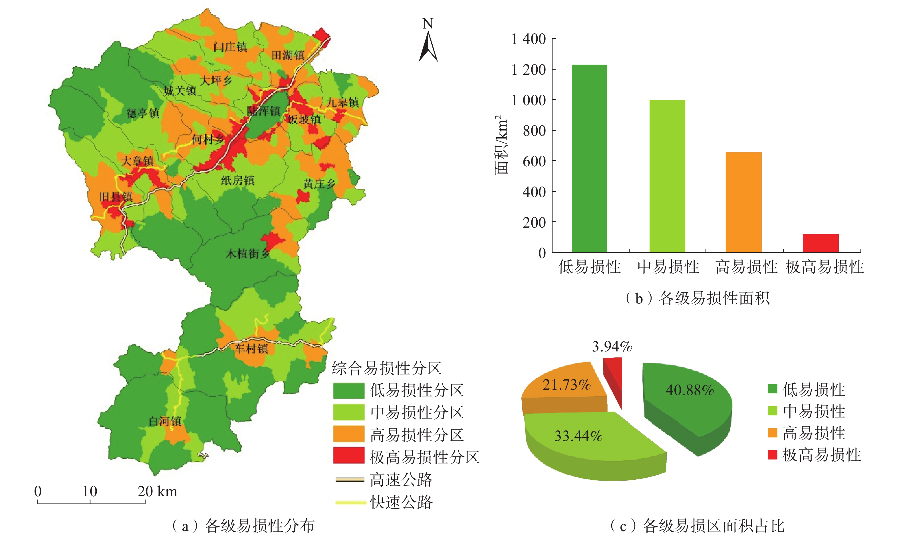
表 3 承灾体易损性赋值表Table 3. Vulnerability evaluation table for disaster-bearing bodies承灾体类型 分级 赋值 受地质灾害直接威胁人口数量 10~100 人 0.40 <10 人 0.20 交通设施 高速公路 0.80 国家级公路 0.70 省级公路 0.40 其他道路 0.25 在ArcGIS环境下,通过计算平均易损性值,选取建筑物易损性、人员易损性和交通易损性中的高值确定易损性指数,结合危险性评价结果,通过矩阵运算,按自然间断法划分为低易损区、中易损区、高易损区、极高易损区,完成嵩县区域易损性分级与区划图9(a)。利用 ArcGIS对研究区地质灾害易损性评价结果进行统计,见图9(b)(c),结果表明:低易损区面积为1229.71 km2,占嵩县全区面积的40.88%;中易损区面积为1005.94 km2,占嵩县全区面积的33.44%;高易损区面积为653.81 km2,占嵩县全区面积的21.73%;极高易损区面积为118.67 km2,占嵩县全区面积的3.94%。
![]() 图 9 嵩县地质灾害易损性分区结果图Figure 9. Geological hazard vulnerability zoning results in Song County
图 9 嵩县地质灾害易损性分区结果图Figure 9. Geological hazard vulnerability zoning results in Song County4.2 地质灾害风险评价
根据联合国对自然灾害风险的定义,地质灾害风险度可以定量表达为:
(3) 式中:R——地质灾害风险度;
H——地质灾害危险度;
V——地质灾害易损度。
基于 ArcGIS 环境下,依据自然间断法将研究区风险性划分为低风险区、中风险区、高风险区和极高风险区,见图10(a)。对分区面积进行统计,见图10(b)(c),结果表明: 其中低风险区面积为962.39 km2,占嵩县全区面积31.98%;中风险区面积为1111.43 km2,占嵩县全区面积的36.94%;高风险区面积为824.56 km2,占嵩县全区面积的27.40%;极高危险区面积为110.61 km2,占嵩县全区面积的3.68%。
5. 结论
(1)基于ArcGIS平台,采用信息量模型选取高程、地貌、工程岩组、植被覆盖度、距构造距离、距水系距离、坡度、坡向等 8个因子建立河南省嵩县地质灾害易发性评价模型,对研究区易发性进行了分区,高易发区主要位于白河镇中东部,高易发区面积为 637.91 km2 ,占嵩县区域面积的21%。嵩县区域极高危险区面积为178.04 km2,占嵩县区域面积的6%,大部分布于白河镇,少量分布于车村镇和九皋镇。
(2)在ArcGIS 环境下,将研究区风险性划分为低风险区、中风险区、高风险区和极高风险区。低风险区面积为965.34 km2,占嵩县全区面积32%;中风险区面积为1114.65 km2,占嵩县全区面积的37%;高风险区面积为826.23 km2,占嵩县全区面积的27%;极高危险区面积为102.68 km2,占嵩县全区面积的3%,其中极高风险区分布于白河镇中部、旧县镇中南、纸房镇西北部、何村乡东南部、饭坡镇北中部及九皋镇中西部,在每个镇分布的面积都较小,说明嵩县区域内风险性整体较低。
(3)研究成果对嵩县防灾、减灾及地质灾害风险管控方面具有很好的应用价值,嵩县区域内地质灾害防治主要以白河镇、纸房镇、何村乡、饭坡镇、旧县镇、大章镇、九皋镇等7个乡镇为主。
-
![]()
图 2 研究区地质构造简图
1—第四系;2—中新统洛阳组;3—下白垩统九店组;4—下古生界二郎坪群;5—上元古界栾川群;6—中—上元古界宽坪群;7—中元古界熊耳群鸡蛋坪组;8—中元古界熊耳群马家河组-鸡蛋坪组并层;9—太古界太华群;10—花岗岩;11—陆浑水库;12—正断层及编号;13—逆断层及编号;14—性质不明断层;15—乡界;16—县界;17—县政府所在地;18—镇(乡)政府所在地
Figure 2. Geological structure sketch map of the study area
![]()
图 3 嵩县地质灾害隐患点分布图
Figure 3. Distribution map of geological hazard potential sites in Song county
![]()
图 4 嵩县地质灾害易发性分区结果图
Figure 4. Results of geological hazard susceptibility zoning in Song County
![]()
图 5 月累计降雨量归一化结果
Figure 5. Normalized results of monthly cumulative rainfall in the study area
![]()
图 9 嵩县地质灾害易损性分区结果图
Figure 9. Geological hazard vulnerability zoning results in Song County
表 1 易发性评价因子分级及信息量值
Table 1 Classification and information value of susceptibility assessment factors
评价因子 指标分级 Ni/N Si/S 信息量值 高程/m [0, 500] 0.3800 0.2146 0.5715 [500, 1000) 0.5800 0.5620 0.0316 [1000, 1500) 0.0400 0.1952 −1.5854 ≥1500 0.0000 0.0282 0.0000 地貌 河谷 0.0558 0.0609 −0.0883 中山 0.2988 0.3985 −0.2879 低山 0.3183 0.3176 0.0037 丘陵 0.3267 0.2230 0.3817 工程岩组 坚硬花岗岩岩组 0.1520 0.3001 −0.6803 坚硬片麻岩岩组 0.0280 0.0563 −0.6992 软弱黏性土岩组 0.1000 0.0881 0.1268 较软弱砾岩岩组 0.0360 0.0164 0.7832 较坚硬砂岩页岩互层岩组 0.0160 0.0113 0.3452 较软弱砂质砾岩岩组 0.1880 0.1178 0.4674 坚硬安山岩类岩组 0.3080 0.3421 −0.1049 较软弱石英云母片岩岩组 0.1520 0.0455 1.2065 较坚硬硅质板岩岩组 0.0120 0.0145 −0.1910 较软弱页岩岩组 0.0040 0.0021 0.6393 较坚硬灰岩岩组 0.0040 0.0057 −0.3503 植被覆盖度 [0, 0.5) 0.1004 0.0553 0.5967 [0.5, 0.65) 0.5100 0.2945 0.5493 [0.65, 0.75) 0.3133 0.3799 −0.1928 [0.75, 1] 0.0763 0.2704 −1.2651 距构造距离/m [0, 500) 0.5000 0.3065 0.4892 [500, 1000) 0.1960 0.1905 0.0286 [1000, 1500) 0.1320 0.1241 0.0616 [1500, 2000) 0.0480 0.0903 −0.6318 ≥2000 0.1240 0.2886 −0.8446 距水系距离/m [0, 500) 0.7800 0.5490 0.3512 [500, 1000) 0.1200 0.2563 −0.7588 [1000, 1500) 0.0600 0.1101 −0.6069 [1500, 2000) 0.0240 0.0415 −0.5476 ≥2000 0.0160 0.0431 −0.9919 坡度/(°) [0, 10) 0.0680 0.1321 −0.6637 [10, 25) 0.3200 0.2117 0.4133 [25, 40) 0.2960 0.2936 0.0082 ≥40 0.3160 0.3627 −0.1378 坡向/(°) FLAT(−1) 0.0000 0.0106 0.0000 N[337.5, 22.5) 0.0680 0.1427 −0.7415 NE[22.5, 67.5) 0.1480 0.1352 0.0903 E[67.5, 112.5) 0.1360 0.1130 0.1856 SE[112.5, 157.5) 0.1720 0.1164 0.3901 S[157.5, 202.5) 0.2160 0.1630 0.2814 SW[202.5, 247.5) 0.1240 0.1236 0.0032 W[247.5, 292.5) 0.0840 0.0922 −0.0928 NW[292.5, 337.5) 0.0520 0.1033 −0.6862  下载: 导出CSV
表 2 嵩县1992—2021年降雨量统计表
Table 2 Statistical table of Rainfall level in Song county from 1992—2021
年份 1992 1993 1994 1995 1996 1997 1998 1999 2000 2001 年降雨量/mm 576.90 675.20 529.60 470.70 959.10 418.10 773.10 589.90 760.30 433.10 月平均降雨量/mm 48.08 56.27 44.13 39.23 79.93 34.84 64.43 49.16 231.50 36.09 年份 2002 2003 2004 2005 2006 2007 2008 2009 2010 2011 年降雨量/mm 657.60 1067.40 690.90 718.40 636.70 565.10 558.80 764.30 924.00 931.50 月平均降雨量/mm 54.80 88.95 57.58 59.87 53.06 47.09 46.57 63.69 77.00 77.63 年份 2012 2013 2014 2015 2016 2017 2018 2019 2020 2021 年降雨量/mm 649.50 518.60 674.10 594.80 562.70 745.30 690.10 690.10 642.50 944.40 月平均降雨量/mm 54.13 43.22 56.18 49.57 46.89 62.11 57.51 53.26 53.54 145.29
下载: 导出CSV
表 3 承灾体易损性赋值表
Table 3 Vulnerability evaluation table for disaster-bearing bodies
承灾体类型 分级 赋值 受地质灾害直接威胁人口数量 10~100 人 0.40 <10 人 0.20 交通设施 高速公路 0.80 国家级公路 0.70 省级公路 0.40 其他道路 0.25
下载: 导出CSV
-
[1] 齐信,唐川,陈州丰,等. 地质灾害风险评价研究[J]. 自然灾害学报,2012,21(5):33 − 40. [QI Xin,TANG Chuan,CHEN Zhoufeng,et al. Research of geohazards risk assessment[J]. Journal of Natural Disasters,2012,21(5):33 − 40. (in Chinese with English abstract) QI Xin, TANG Chuan, CHEN Zhoufeng, et al. Research of geohazards risk assessment[J]. Journal of Natural Disasters, 2012, 21(5): 33-40. (in Chinese with English abstract)
[2] MANTOVANI F,SOETERS R,VAN WESTEN C J. Remote sensing techniques for landslide studies and hazard zonation in Europe[J]. Geomorphology,1996,15(3/4):213 − 225.
[3] MICHAEL-LEIBA M,BAYNES F,SCOTT G,et al. Regional landslide risk to the Cairns community[J]. Natural Hazards,2003,30(2):233 − 249. DOI: 10.1023/A:1026122518661
[4] UROMEIHY A,MAHDAVIFAR M R. Landslide hazard zonation of the khorshrostam area,Iran[J]. Bulletin of Engineering Geology and the Environment,2000,58(3):207 − 213. DOI: 10.1007/s100640050076
[5] ALEOTTI P,CHOWDHURY R. Landslide hazard assessment:summary review and new perspectives[J]. Bulletin of Engineering Geology and the Environment,1999,58(1):21 − 44. DOI: 10.1007/s100640050066
[6] Einstein H H. Landslide risk-systenatic approaches to assessment and management[C]//In: Cruden D. and Fell R. ( eds. ) , Landslide Risk Assessment. Rotterdam: Balkema, 1997: 25 − 50.
[7] VAN WESTEN C. Geo-Information tools for landslide risk assessment: An overview of recent developments[M]//Landslides: Evaluation and Stabilization/Glissement de Terrain: Evaluation et Stabilisation, Set of 2 Volumes. CRC Press, 2004: 39 − 56.
[8] 罗路广,裴向军,谷虎,等. 基于GIS的“8·8”九寨沟地震景区地质灾害风险评价[J]. 自然灾害学报,2020,29(3):193 − 202. [LUO Luguang,PEI Xiangjun,GU Hu,et al. Risk assessment of geohazards induced by “8·8” earthquake based on GIS in Jiuzhaigou scenic area[J]. Journal of Natural Disasters,2020,29(3):193 − 202. (in Chinese with English abstract) LUO Luguang, PEI Xiangjun, GU Hu, et al. Risk assessment of geohazards induced by “8.8” earthquake based on GIS in Jiuzhaigou scenic area[J]. Journal of Natural Disasters, 2020, 29(3): 193-202. (in Chinese with English abstract)
[9] 高克昌,崔鹏,赵纯勇,等. 基于地理信息系统和信息量模型的滑坡危险性评价—以重庆万州为例[J]. 岩石力学与工程学报,2006,25(5):991 − 996. [GAO Kechang,CUI Peng,ZHAO Chunyong,et al. Landslide hazard evaluation of Wanzhou based on GIS information value method in the Three Gorges Reservoir[J]. Chinese Journal of Rock Mechanics and Engineering,2006,25(5):991 − 996. (in Chinese) GAO Kechang, CUI Peng, ZHAO Chunyong, et al. Landslide hazard evaluation of Wanzhou based on GIS information value method in the Three Gorges Reservoir[J]. Chinese Journal of Rock Mechanics and Engineering, 2006, 25(5): </span>991-996<spanstyle=color: rgb(51. (in Chinese)
[10] 阮沈勇,黄润秋. 基于GIS的信息量法模型在地质灾害危险性区划中的应用[J]. 成都理工学院学报,2001,28(1):89 − 92. [RUAN Shenyong,HUANG Runqiu. Application of GIS-based information model on assessment of geological hazards risk[J]. Journal of Chengdu University of Technology,2001,28(1):89 − 92. (in Chinese with English abstract) RUAN Shenyong, HUANG Runqiu. Application of gis-based information model on assessment of g eological hazards risk[J]. Journal of Chengdu University of Technology, 2001, 28(1): 89-92. (in Chinese with English abstract)
[11] 刘福臻,王灵,肖东升. 机器学习模型在滑坡易发性评价中的应用[J]. 中国地质灾害与防治学报,2021,32(6):98 − 106. [LIU Fuzhen,WANG Ling,XIAO Dongsheng. Application of machine learning model in landslide susceptibility evaluation[J]. The Chinese Journal of Geological Hazard and Control,2021,32(6):98 − 106. (in Chinese with English abstract) LIU Fuzhen, WANG Ling, XIAO Dongsheng. Application of machine learning model in landslide susceptibility evaluation[J]. The Chinese Journal of Geological Hazard and Control, 2021, 32(6): 98-106. (in Chinese with English abstract)
[12] 倪晓娇,南颖. 基于GIS的长白山地区地质灾害风险综合评估[J]. 自然灾害学报,2014,23(1):112 − 120. [NI Xiaojiao,NAN Ying. Comprehensive assessment of geological disasters risk in Changbai Mountain region based on GIS[J]. Journal of Natural Disasters,2014,23(1):112 − 120. (in Chinese with English abstract) NI Xiaojiao, NAN Ying. Comprehensive assessment of geological disasters risk in Changbai Mountain region based on GIS[J]. Journal of Natural Disasters, 2014, 23(1): 112-120. (in Chinese with English abstract)
[13] 冯凡,唐亚明,潘学树,等. 不同尺度下地质灾害风险评价方法探讨—以陕西吴堡县为例[J]. 中国地质灾害与防治学报,2022,33(2):115 − 124. [FENG Fan,TANG Yaming,PAN Xueshu,et al. An attempt of risk assessment of geological hazards in different scales:A case study in Wubao County of Shaanxi Province[J]. The Chinese Journal of Geological Hazard and Control,2022,33(2):115 − 124. (in Chinese with English abstract) FENG Fan, TANG Yaming, PAN Xueshu, et al. An attempt of risk assessment of geological hazards in different scales: a case study in Wubao County of Shaanxi Province[J]. The Chinese Journal of Geological Hazard and Control, 2022, 33(2): 115-124. (in Chinese with English abstract)
[14] 李阳春,刘黔云,李潇,等. 基于机器学习的滑坡崩塌地质灾害气象风险预警研究[J]. 中国地质灾害与防治学报,2021,32(3):118 − 123. [LI Yangchun,LIU Qianyun,LI Xiao,et al. Exploring early warning and forecasting of meteorological risk of landslide and rockfall induced by meteorological factors by the approach of machine learning[J]. The Chinese Journal of Geological Hazard and Control,2021,32(3):118 − 123. (in Chinese with English abstract) LI Yangchun, LIU Qianyun, LI Xiao, et al. Exploring early warning and forecasting of meteorological risk of landslide and rockfall induced by meteorological factors by the approach of machine learning[J]. The Chinese Journal of Geological Hazard and Control, 2021, 32(3): 118-123. (in Chinese with English abstract)
[15] 乔建平,王萌,石莉莉. 区域滑坡风险评估中的风险区划与概率分析[J]. 自然灾害学报,2012,21(2):51 − 56. [QIAO Jianping,WANG Meng,SHI Lili. Risk zoning and probability analysis of regional landslide risk assessment[J]. Journal of Natural Disasters,2012,21(2):51 − 56. (in Chinese with English abstract) QIAO Jianping, WANG Meng, SHI Lili. Risk zoning and probability analysis of regional landslide risk assessment[J]. Journal of Natural Disasters, 2012, 21(2): 51-56. (in Chinese with English abstract)
[16] 刘希林. 泥石流风险评价中若干问题的探讨[J]. 山地学报,2000,18(4):341 − 345. [LIU Xilin. Approaches to risk assessment of debris flow[J]. Journal of Mountain Research,2000,18(4):341 − 345. (in Chinese with English abstract) LIU Xilin. Approaches to risk assessment of debris flow[J]. Journal of Mountain Research, 2000, 18(4): 341-345. (in Chinese with English abstract)
[17] 王嘉君,何亚伯,杨琳,等. 基于GIS的山区村镇多灾种耦合风险评估[J]. 中国地质灾害与防治学报,2018,29(1):102 − 112. [WANG Jiajun,HE Yabo,YANG Lin,et al. Comprehensive multi-hazard risk assessment of villages and towns in mountain areas based on GIS[J]. The Chinese Journal of Geological Hazard and Control,2018,29(1):102 − 112. (in Chinese with English abstract) WANG Jiajun, HE Yabo, YANG Lin, et al. Comprehensive multi-hazard risk assessment of villages and towns in mountain areas based on GIS[J]. The Chinese Journal of Geological Hazard and Control, 2018, 29(1): 102-112. (in Chinese with English abstract)
[18] 刘传正. 论地质灾害风险识别问题[J]. 水文地质工程地质,2017,44(4):1 − 7. [LIU Chuanzheng. Research on the risk recognition of geological disasters[J]. Hydrogeology & Engineering Geology,2017,44(4):1 − 7. (in Chinese with English abstract) LIU Chuanzheng. Research on the risk recognition of geological disasters[J]. Hydrogeology & Engineering Geology, 2017, 44(4): 1-7. (in Chinese with English abstract)
[19] 刘传正. 崩塌滑坡灾害风险识别方法初步研究[J]. 工程地质学报,2019,27(1):88 − 97. [LIU Chuanzheng. Analysis methods on the risk identification of landslide disasters[J]. Journal of Engineering Geology,2019,27(1):88 − 97. (in Chinese with English abstract) LIU Chuanzheng. Analysis methods on the risk identification of landslide disasters[J]. Journal of Engineering Geology, 2019, 27(1): 88-97. (in Chinese with English abstract)
[20] ALEXANDER E D, Natural Disasters[M]. London: UCL Press Limited, 1993: 1 − 632.
-
期刊类型引用(15)
1. 王勇,邢振涛,李锁,闫勇,司甜. 基于SBAS-InSAR和光学遥感的天津市北部山区潜在滑坡识别研究. 灾害学. 2025(01): 30-35 .  百度学术
百度学术
2. 毛正君,李欢,石硕杰,孙婕文,仲佳鑫,于海泳. 面向对象的无人机遥感影像区域滑坡承灾体信息提取研究. 工程地质学报. 2025(01): 171-185 . 百度学术
3. 冯谕,曾怀恩,涂鹏飞. 遗传算法下的滑坡蠕滑位移预测模型研究. 中国地质灾害与防治学报. 2024(01): 82-91 . 本站查看
4. 杨豹,赵瑞志,王海波,李晓光,吕钊,赵阳,王梦云. 遥感技术对地质灾害早期识别和动态监测——以昌波乡至羊拉乡段为例. 科学技术与工程. 2024(05): 1823-1836 . 百度学术
5. 李恒丽,陈克全. 云南维西县新塘房滑坡形成条件及防治措施探讨. 云南地质. 2024(01): 115-120 . 百度学术
6. 毛正君,于海泳,梁伟,马旭,仲佳鑫,高广胜,石硕杰,田彦山. 基于无人机倾斜摄影测量三维建模的区域黄土滑坡识别及特征分析. 中国地质. 2024(02): 561-576 . 百度学术
7. 薛玉芹,滕秀华,孟大鹏. 遥感测量在采矿塌陷地监测及矿山地质灾害治理方面的应用. 世界有色金属. 2024(03): 157-159 . 百度学术
8. 党杰,杨亮,段方情,范宣梅. 贵州晴隆红寨大型古滑坡复活变形特征及成因分析. 中国地质灾害与防治学报. 2024(04): 25-35 . 本站查看
9. 孙成永. InSAR技术在河南信阳新县地质灾害风险调查中的应用. 城市地质. 2024(03): 383-389 . 百度学术
10. 孙琪皓,刘桂卫,王飞,张璇钰,王衍汇. 铁路地质灾害早期识别与监测预警技术及应用研究. 铁道标准设计. 2024(09): 24-31 . 百度学术
11. 钱雨扬,孔令利,余洲,杨国兴,朋仁锋. 基于InSAR-光学影像的白鹤滩库区地质灾害隐患识别. 人民长江. 2024(S2): 107-112+120 . 百度学术
12. 韩民赛,刘岁海,罗明,蒋韬,孙大振. 滑坡预测预报研究与进展. 地质装备. 2023(01): 22-26+39 . 百度学术
13. 朱伟伟. 遥感技术在地质灾害监测与管理中的应用. 安徽地质. 2023(01): 75-77+90 . 百度学术
14. 黎浩良,杨莹辉,许强,宋家苇,李鹏飞,陈强,姚智博. 高寒山区地质灾害季节分区InSAR早期识别研究——以东构造结地区为例. 工程地质学报. 2023(03): 780-795 . 百度学术
15. 李芳军. 黄土滑坡地质灾害监测预警方法与技术探讨. 冶金管理. 2023(15): 82-84 . 百度学术
其他类型引用(18)


计量
- 文章访问数: 1640
- HTML全文浏览量: 1255
- PDF下载量: 277
- 被引次数: 33
 邮件订阅
邮件订阅 RSS
RSS