

Subsidence prediction of high-fill areas based on InSAR monitoring data and the PSO-SVR model
-
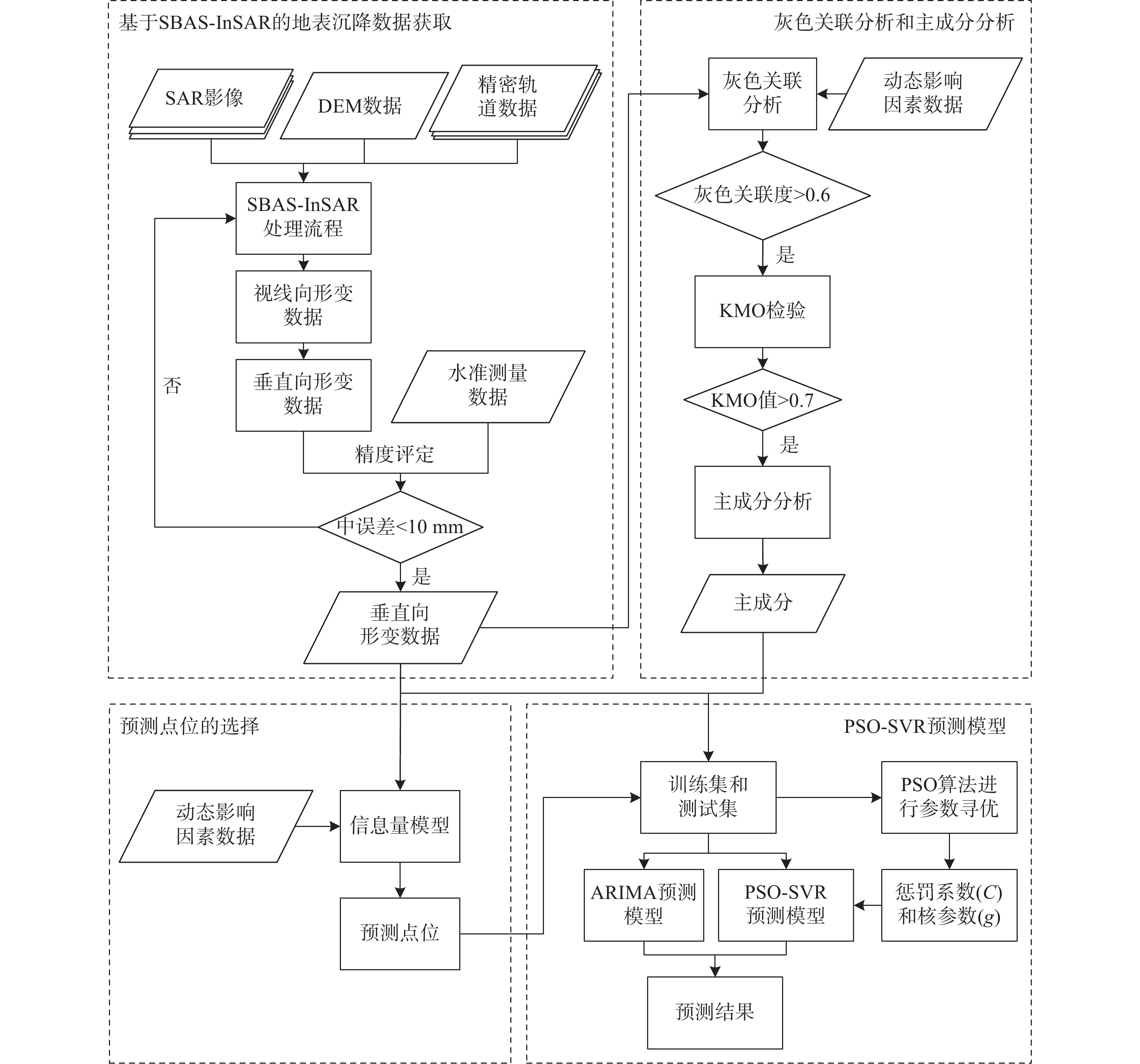
摘要:
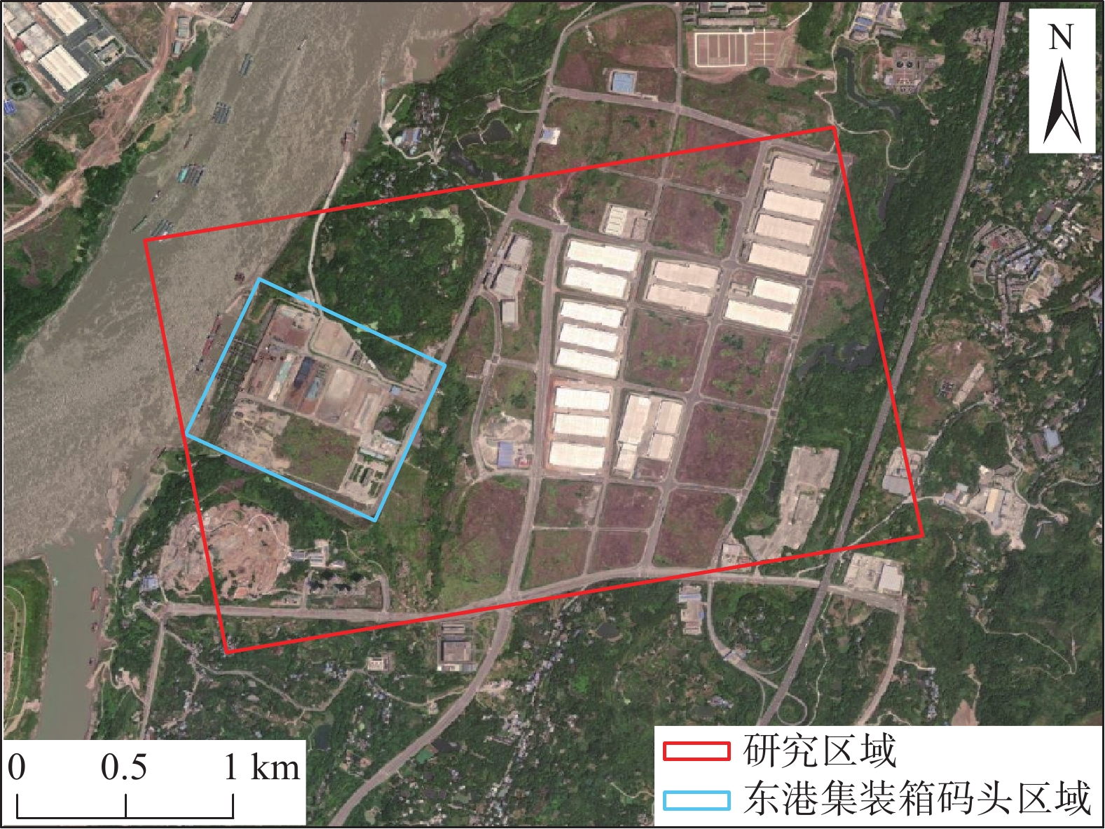
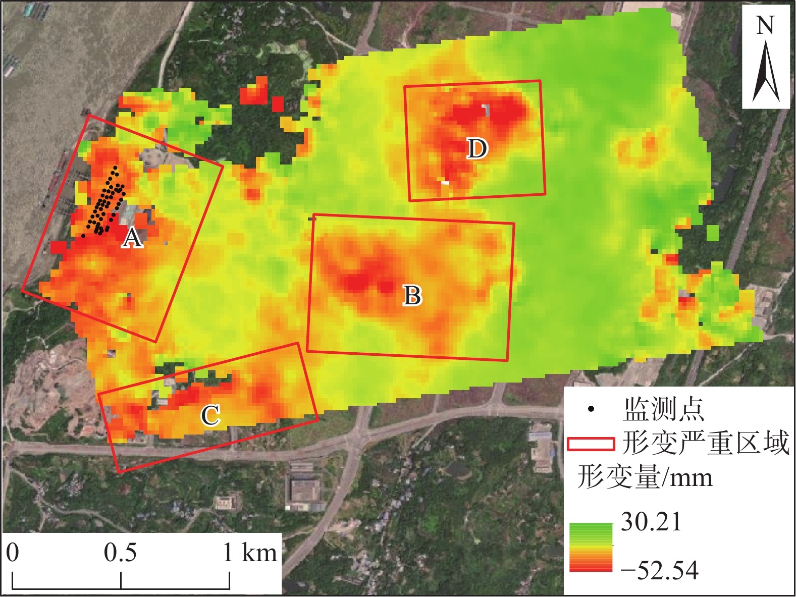
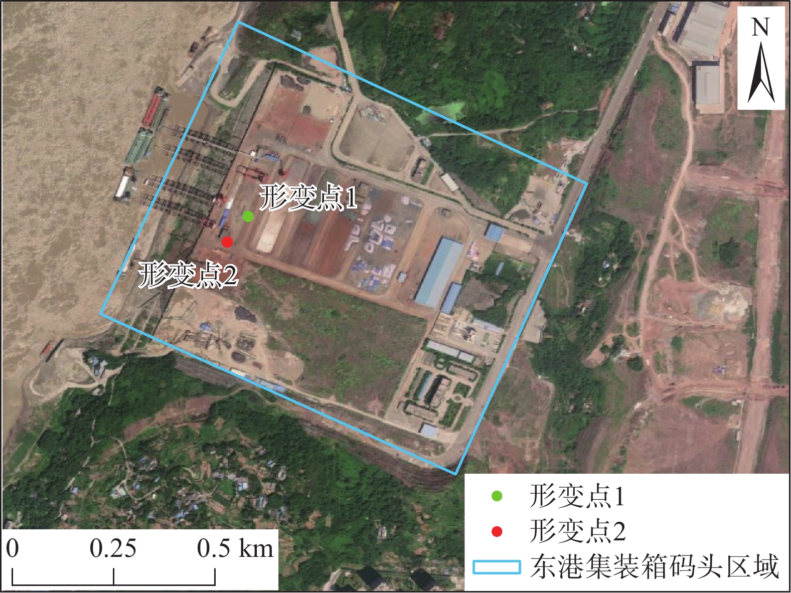
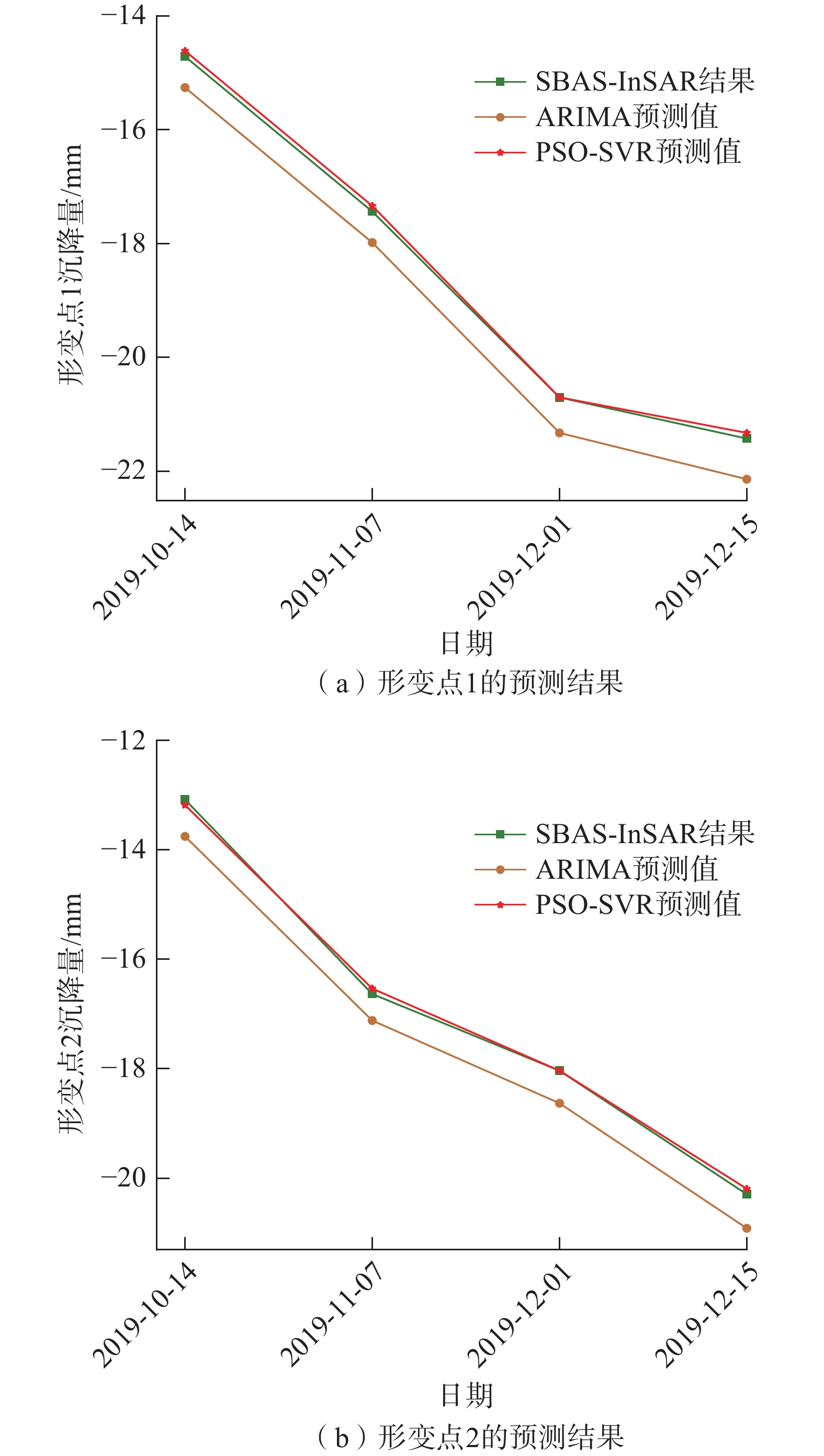
基于小基线集干涉测量技术(small baseline subsets interferometric synthetic aperture radar, SBAS-InSAR)和机器学习知识对高填方区域进行地表沉降监测及预测,对工程项目的施工、检修、运营等工作都具有重要的指导意义。文章以重庆东港集装箱码头为研究对象,选取2018—2019年覆盖研究区的31景Sentinel-1A数据,利用SBAS-InSAR技术获取该区域的地表沉降数据,并进行内外精度评定;通过信息量模型分析地表沉降易发地地势特点,选择预测点位;通过灰色关联分析计算动态影响因素与沉降量之间的灰色关联度,使用主成分分析法从影响因素中提取出主成分,构建训练集和测试集,通过粒子群算法-支持向量机法(particle swarm optimization-support vector regression, PSO-SVR)预测模型对测试集数据进行预测。为验证该模型在高填方区域沉降预测的可靠性和优异性,将自回归差分整合移动平均模型(autoregressive integrated moving average model, ARIMA)作为对比模型,分别将PSO-SVR模型的预测结果和ARIMA模型的预测结果与测试集进行对比。结果表明:PSO-SVR模型的预测精度优于ARIMA模型,在高填方区域地表沉降预测中具有较好的实用性。
Abstract:Based on SBAS-InSAR technology and machine learning knowledge, the monitoring and prediction of surface settlement in high-fill areas have important guiding significance for construction, maintenance, and operation of engineering projects. This study takes the Chongqing Donggang Container Terminal as the research object, and utilizes 31 scenes of Sentinel-1A data from 2018 to 2019. The surface subsidence data of the area is obtained by SBAS-InSAR technology, and the internal and external accuracy is evaluated. The topography characteristics of the prone areas of surface subsidence were analyzed through an information quantity model to select prediction points. Grey Relational Analysis (GRA) was used to calculate the grey correlation degree between dynamic influencing factors and subsidence. Principal component analysis was used to extract principal components from influencing factors, and training and testing sets were constructed. PSO-SVR prediction model was used to predict the testing set data. To verify the reliability and superiority of the model in subsidence prediction in high-fill areas, the ARIMA model was used as a comparative model, and the prediction results of the PSO-SVR model and the ARIMA model were compared with the testing set. The results show that the prediction accuracy of the PSO-SVR model is better than that of the ARIMA model, and it has better practicality in predicting surface subsidence in high-fill areas.
-
0. 引言
地质环境质量是判定和评价一个区域地质环境总体条件和建设适宜性好坏的指标,能够为区域地质环境规划和地质环境问题的治理提供决策支持[1-2]。层次分析法是一种多要素综合评价方法,在地质环境质量评价中发挥着重要作用[3-5],其中评价指标体系的建立是利用层次分析法评价地质环境质量的关键。目前的研究多是利用一套评价指标体系对包含多种地貌类型的区域开展地质环境质量评价[6-7],而不同地貌类型的地质环境影响因子有所不同,因此导致地质环境质量评价结果在不同的地貌类型间有较明显的差异,评价结果不能有效体现研究区域不同地貌类型的地质环境质量特征。
针对上述问题,本研究以北京地区为例,根据北京地区地质环境特点,采用层次分析法建立基于不同地貌类型的地质环境质量评价体系,分别对山区和平原区开展地质环境质量评价。评价结果与基于单一评价体系的评价结果进行比较,探索更加合理的地质环境质量评价指标体系,有利于北京市地质环境的总体保护与防治。
1. 研究区地质环境概况
北京市位于东经115°25′~117°30′,北纬39°28′~41°05′,地处华北平原北部,总体地势西北高、东南低(图1)。西北部为太行山脉和燕山山脉交汇形成的中低山地貌,东南部为各大水系冲洪积形成的平原地貌,其中山区面积广泛,占总面积的62%。
北京地区存在的主要地质环境问题分为山区和平原区两部分。在山区主要表现为矿山开发导致的环境破坏,突发地质灾害隐患分布广泛。北京市各类矿点共计386处,矿山占地面积100.59 km2,虽然绝大多数矿点已关停,但是以往的矿业活动仍严重影响着当地的地质环境。另一方面,北京市突发地质灾害较为发育,有数量多、分布广、种类多的特点;目前北京市各类地质灾害隐患点达5037处,主要分布在北部和西部山区的10个郊区县内,隐患数量以密云区、房山区、怀柔区居多,地质灾害隐患种类包括崩塌、滑坡、不稳定斜坡、泥石流和地面塌陷5种类型。
在平原区主要为活动断裂引起的地表位移和失稳,以及地下水过度开采导致的地面沉降。北京平原区活动断裂主要包括:南口孙河断裂带、高丽营断裂带和夏垫断裂带,其中高丽营断裂带在高丽营附近断裂面直达地表,近地表断距1.58 m[8]。截至2014年,北京平原区共发育7个地面沉降中心,主要分布在朝阳区、昌平区、顺义区、大兴区和通州区,最大累积沉降量(1955—2014年)1585 mm,历史最大沉降速率达:159.6 mm/a。
2. 研究方法
本研究的总体思路是,针对北京市山区和平原区的地质环境特点,分别建立两套不同地貌类型下的评价指标体系开展地质环境质量评价。具体方法是,将研究区域划分为一系列独立的评价单元,采用层次分析法对每一个评价单元进行地质环境质量要素的评价,形成评价单元的属性数据库,通过空间分析技术生成北京市全域地质环境质量综合评价结果。
层次分析法AHP(Analytic Hierarchy Process)是一种定性分析和定量分析相结合的决策分析方法[9-10],通过构建地质环境质量评价指标体系层次结构模型及其重要性判断矩阵,获取各评价指标的权重值[11-13],运用综合指数法[14]建立研究区地质环境质量评价综合指数计算模型,开展区域地质环境质量综合评价模型公式:
式中:
3. 地质环境质量评价
3.1 数据获取
本研究全面收集了近五年与北京市地质环境相关的数据资料。主要分为属性数据和空间数据两类。其中属性数据主要包括地质灾害资料、社会人口资料、矿业生产资料等;空间数据主要包括区域地质资料、遥感影像资料、DEM高程数据、水文地质资料等。
3.2 指标体系的建立
评价地质环境质量涉及的因素主要有区域地质环境背景、地质条件的稳定性、地质环境问题及人类工程活动等诸多因素,但影响地质环境质量的优劣是相对的,目前尚无统一的标准去衡量和描述地质环境质量的好坏[15]。选择对评价目标起主导作用、比较稳定、可量化的参评指标,构建合理的评价指标体系是地质环境质量评价工作的关键[16]。
本次地质环境质量指标的选取在参考《区域水文地质工程地质环境地质综合勘查规范》和《生态环境质量评价技术规定》等相关规范[17-18]的同时,结合研究区地质环境现状和存在的地质环境问题,遵循科学性、系统性、独立性和方便性的地质环境质量评价指标体系构建的基本原则,筛选出了13个评价指标,分别构建了北京市山区和平原区三层次的地质环境质量评价指标体系(图2、图3)。第一层为目标层,即北京市地质环境质量;第二层为准则层,包括地质条件、资源环境和人类活动3个评价准则;第三层为指标层,即每个准则所包含的具体的评价指标(表1)。
![]() 图 2 山区地质环境质量评价指标体系Figure 2. Hierarchical structure diagramof the geological environment quality evaluation system in mountain
图 2 山区地质环境质量评价指标体系Figure 2. Hierarchical structure diagramof the geological environment quality evaluation system in mountain![]() 图 3 平原区地质环境质量评价指标体系Figure 3. Hierarchical structure diagramof the geological environment quality evaluation system in plain表 1 评价指标及其含义Table 1. Evaluation indexes
图 3 平原区地质环境质量评价指标体系Figure 3. Hierarchical structure diagramof the geological environment quality evaluation system in plain表 1 评价指标及其含义Table 1. Evaluation indexes序号 评价指标 含义 1 地表高程/m 地表海拔高度,影响地质环境的基础因素之一,它控制着水文、植被、人类活动等因素。 2 地形坡度/(°) 反映地形起伏的地形定量指标,水土流失、地质灾害、水资源等都与坡度有很大的关系。 3 岩土类型 人类生存的最基本的物质条件,评判依据是人类对岩土体的适应性,一般而言,岩性越软,人类的适应性越强。 4 地震烈度 地震时某一地区的地面和各类建筑物遭受到一次地震影响的强弱程度,表征地壳稳定性的重要因素。 5 活动断裂距离/m 某一地区活动断裂对人类活动建设存在的影响程度,用与活动断裂的距离表征。 6 灾害密度/(个·km−2) 对地区地质灾害严重程度的表征,用每平方公里地质灾害的数量表示。 7 地面沉降量/mm 地面沉降是影响人类工程活动建设的重要因素之一,用累积沉降量表示。 8 植被指数 某一地区的植被覆盖程度,用NDVI指数表征,植被是影响区域地质环境质量的重要因素之一。 9 水体面积指数 某地区地表水资源量,用水体面积指数表征,一般情况下,地表水资源量越大,对环境质量的有益贡献就越大。 10 土壤质量 指土壤在一定生态系统内支持生物的生产能力,净化环境能力,促进动植物及人类健康的能力,用土壤质量等级表征。 11 地下水质量 地下水资源的质量状况,用地下水污染的程度表征,如未受污染、轻微污染、严重污染。 12 人口密度/(人·km−2) 单位面积内的人口数量,人口是制约地区经济发展的主要因素,人口密度越大,其地质环境质量也会越差。 13 矿山密度/(个·km−2) 单位面积内的矿点数量,采矿活动严重影响着当地的地质环境质量。 3.3 指标量化分级
不同的指标数据具有不同的单位与量纲,无法直接进行比较和运算,因此必须对数据进行标准量化处理,形成数据形式统一的属性数据库,以便进行指标间的综合运算。地质环境在区域上的差异性决定了评价指标的选取和量化分级具有很强的区域特征,因此量化分级过程必须充分考虑研究区地质环境的实际情况。本研究通过现场调查和专家咨询,同时结合相关规范[19-20],将各评价指标就地质环境质量分为良好、较好、一般3个级别,分别赋值为3分、2分、1分(表2),分值越大对应的地质环境质量越好。
表 2 评价指标量化分级标准Table 2. Grading quantitative standard of geological environment quality indexes影响要素 评价指标 质量状态评分(山区) 质量状态评分(平原区) 良好(3分) 较好(2分) 一般(1分) 良好(3分) 较好(2分) 一般(1分) 地质条件 地表高程/m < 500 500~1000 > 1000 – – – 地形坡度/(°) < 5° 5°~25° > 25° – – – 岩土类型 软岩/松散土 中硬岩 坚硬岩 – – – 灾害密度(个·km−2) 0 1 > 1 – – – 地震烈度/度 < VII VII > VII < VII VII > VII 活动断裂距离/m – – – > 3000 3000~200 < 200 地面沉降量/mm – – – < 500 500~1500 > 1500 资源环境 植被指数 > 0.7 0.7~0.5 < 0.5 > 0.6 0.6~0.3 < 0.3 水体面积指数 1.0~0.5 0.5~0.1 < 0.1 1.0~0.3 0.3~0.05 < 0.05 土壤质量 – – – 优质、良好 好 中等 地下水质量 – – – 未污染 轻污染/中污染 严重污染 人类活动 人口密度/(人·km−2) < 550 550~1500 > 1500 < 1000 1000~7000 > 7000 矿山密度/(个·km−2) 0 1 > 1 0 1 > 1 将收集到的指标数据进行矢量化,并对各评价因子数据进行了1 km×1 km的重采样,即设定综合评价的基本单元大小为1 km2。根据评价指标分级量化标准,对重采样后的指标数据进行量化分级,获得每个评价指标的量化分级图,如图4所示(限于篇幅,仅列部分典型指标)。
3.4 指标权重
采用层次分析法确定各评价指标的权重。经过专家咨询,构建各层级评价要素的重要性判断矩阵,经一致性检验,各层级判断矩阵均能达到满意的一致性,此处不一一列出。根据层次单排序法获得北京市山区和平原区各评价指标的权重(表3、表4)。
表 3 山区地质环境质量评价指标权重Table 3. Geological environment quality evaluation index weight in mountain一级因子 权重 评价指标 总权重 地质条件 0.5499 地表高程/m 0.0687 地形坡度/(°) 0.1520 岩土类型 0.0962 地震烈度/度 0.0469 灾害密度(个·km−2) 0.1862 资源环境 0.2098 植被指数 0.0699 水体面积指数 0.1399 人类活动 0.2402 人口密度/(人·km−2) 0.0601 矿山密度/(个·km−2) 0.1802 表 4 平原区地质环境质量评价指标权重Table 4. Geological environment quality evaluation index weight in plain一级因子 权重 评价指标 总权重 地质条件 0.4434 活动断裂距离/m 0.1774 地震烈度/(°) 0.0887 地面沉降量/mm 0.1774 资源环境 0.3874 植被指数 0.0655 水体面积指数 0.0793 土壤质量 0.1311 地下水质量 0.1115 人类活动 0.1692 人口密度/(人·km−2) 0.0423 矿山密度/(个·km−2) 0.1269 3.5 评价结果
各评价指标的权重值确定后,利用综合指数法模型公式,获得北京山区和平原区地质环境质量评价综合指数计算模型,通过空间分析技术获得各单元的地质环境质量综合评价结果(图5)。利用自然断点法,分别对北京山区和平原区地质环境质量指数进行等级区划,总体上将北京地区地质环境质量划分为3个区:地质环境良好区、地质环境较好区和地质环境一般区(图6-a)。
4. 讨论
利用上述方法和指标因子建立针对北京市全域的单一地质环境质量评价指标体系(图7),通过层次分析和专家评判确定指标权重,利用综合指数法开展北京市全域地质环境质量评价,评价结果(图6-b)与基于地貌的多重评价指标体系评价结果(图6-a)进行比较。
![]() 图 6 北京市全域地质环境质量评价指标体系Figure 6. The index system of geological environment quality evaluation of Beijing
图 6 北京市全域地质环境质量评价指标体系Figure 6. The index system of geological environment quality evaluation of Beijing![]() 图 7 北京市地质环境质量分级区划对比Figure 7. Comparison of geological environment quality zoning of Beijing
图 7 北京市地质环境质量分级区划对比Figure 7. Comparison of geological environment quality zoning of Beijing在单一评价指标体系的评价结果中,山区大部为地质环境一般区,山前丘陵-平原地带地质环境良好区,中部平原区为地质环境较好区,地质环境质量区划显示出了明显的地貌特征,地质环境质量评价结果的分带性较为明显,空间分异性较差。在多重评价指标体系的评价结果中,地质环境质量的空间分异性明显得到了增强,山区地质环境良好区和较好区的范围明显增大,地质环境质量的空间分布体现了多种指标因素的影响;平原区活动断裂、地面沉降两大因素的影响得到增强,地质环境一般区的面积明显扩大,地质环境良好区也不局限于山前丘陵-平原,综合体现了土壤质量、地下水质量等因素的影响。
分析上述结果,在参与地质环境质量评价的指标因素中,部分指标受地貌影响具有空间上的局限性,不能代表北京全域的特征,如灾害密度、地形坡度、矿山密度等指标偏重于影响山区地质环境,而活动断裂、地面沉降则只存在于平原区。这些受地貌影响明显的指标因子在同一评价指标体系中被赋予权重值,降低了其对某个地貌类型的影响程度,因此导致地质环境质量评价结果在不同的地貌类型间有较明显的差异,评价结果不能有效体现研究区域不同地貌类型的地质环境质量特征,地质环境质量评价结果的合理性和准确性较差。
5. 结论
不同的地貌类型影响地质环境质量的因素有所不同。在区域地质环境质量评价中,相比于单一评价指标体系,建立基于地貌类型的多重评价指标体系,评价结果能够更加合理、准确地反映研究区的地质环境质量及空间分布状况。
-
![]()
图 6 各模型预测结果
Figure 6. The prediction results of each model for each deformation points
表 1 监测点地表形变结果
Table 1 Surface deformation results of monitoring sites
点名 基于SBAS-InSAR技术获取的LOS向形变数据/mm 基于SBAS-InSAR技术获取的垂直形变数据/mm 水准测量获取的形变量/mm 1 −12.75 −15.26 −15.20 2 −13.62 −16.29 −13.60 3 −13.62 −16.29 −9.20 …… …… …… …… 46 −22.75 −27.22 −39.80 47 −21.42 −25.63 −36.00 48 −20.45 −24.46 −17.40  下载: 导出CSV
表 2 静态影响因素信息量计算结果
Table 2 Information quantity calculation results of static influencing factors
静态影响因子 影响因子分级 信息量 高程/m 151~187 0.82 187~231 0.07 231~263 0.64 263~292 −1.28 292~333 −5.62 坡度/(°) 0~5 −0.32 5~10 0.00 10~15 0.08 15~20 0.37 >20 0.20 坡向 平坡 −1.78 北坡 0.36 东北坡 −0.02 东坡 −0.80 东南坡 −0.47 南坡 −0.16 西南坡 0.42 西坡 −0.21 西北坡 0.23 平面曲率 0~16.9 0.05 16.9~33.6 −0.22 33.6~50.5 −0.14 50.5~67.4 −0.19 67.4~81.5 0.31 剖面曲率 0~2.9 0.01 2.9~5.8 −0.01 5.8~9 −0.11 9~13.6 0.24 13.6~26.8 −0.23 道路缓冲区/m 0~30 −0.78 30~60 −0.19 60~90 0.13 >90 0.28 水系缓冲区/m 0~500 −0.08 500~1000 0.68 1000~1500 −0.74 1500~2 000 0.48 >2 000 −2.68 地形起伏度/m 0~7 −0.48 7~13 0.00 13~19 0.13 19~29 0.25 29~48 0.26 人类活动缓冲区/m 0~100 0.56 100~200 −1.07 200~300 −1.13 300~400 −0.64 >400 −1.89
下载: 导出CSV
表 3 灰色关联度
Table 3 Summary table of grey relational degree
影响因素 气温 水位 地下水 NDVI 降雨量 灰色关联度 0.758 4 0.758 3 0.692 9 0.666 7 0.622 3
下载: 导出CSV
表 4 PSO-SVR模型的预测结果
Table 4 Prediction results of the PSO-SVR model
点号 日期 真实值/mm 预测值/mm 形变点1 2019-10-14 −14.71 −14.61 2019-11-07 −17.43 −17.34 2019-12-01 −20.71 −20.70 2019-12-25 −21.42 −21.32 形变点2 2019-10-14 −13.08 −13.18 2019-11-07 −16.63 −16.53 2019-12-01 −18.04 −18.03 2019-12-25 −20.29 −20.19
下载: 导出CSV
表 5 ARIMA模型的预测结果
Table 5 Prediction results of the ARIMA model
点号 日期 真实值/mm 预测值/mm 形变点1 2019-10-14 −14.71 −15.26 2019-11-07 −17.44 −17.98 2019-12-01 −20.70 −21.32 2019-12-25 −21.42 −22.14 形变点2 2019-10-14 −13.08 −13.75 2019-11-07 −16.63 −17.12 2019-12-01 −18.04 −18.63 2019-12-25 −20.29 −20.91
下载: 导出CSV
表 6 精度评定表
Table 6 Accuracy evaluation table
模型 点号 MAE MSE R2 PSO-SVR 形变点1 0.075 3 0.007 5 0.999 0 形变点2 0.075 0 0.007 5 0.998 9 ARIMA 形变点1 0.606 9 0.373 1 0.948 3 形变点2 0.593 3 0.356 8 0.947 9
下载: 导出CSV
-
[1] 刘强. 时序InSAR技术在中型城市地表形变时空特征应用及预测分析[D]. 抚州: 东华理工大学, 2022 LIU Qiang. Application and prediction analysis of time series InSAR technology in temporal and spatial characteristics of surface deformation in medium-sized cities[D]. Fuzhou: East China Institute of Technology, 2022. (in Chinese with English abstract)
[2] 李金超. 基于InSAR和Sentinel-1A的淮南矿区形变灾害监测研究[D]. 合肥: 合肥工业大学, 2021 LI Jinchao. Research on deformation disaster monitoring in Huainan mining area based on InSAR and sentinel-1A[D]. Hefei: Hefei University of Technology, 2021. (in Chinese with English abstract)
[3] FERRETTI A,PRATI C,ROCCA F. Permanent scatterers in SAR interferometry[J]. IEEE Transactions on Geoscience and Remote Sensing,2001,39(1):8 − 20. DOI: 10.1109/36.898661
[4] BERARDINO P,FORNARO G,LANARI R,et al. A new algorithm for surface deformation monitoring based on small baseline differential SAR interferograms[J]. IEEE Transactions on Geoscience and Remote Sensing,2002,40(11):2375 − 2383. DOI: 10.1109/TGRS.2002.803792
[5] 于书媛,杨源源,张鹏飞,等. 运用时序InSAR技术监测合肥市地面沉降及断裂活动[J]. 大地测量与地球动力学,2021,41(4):398 − 402. [YU Shuyuan,YANG Yuanyuan,ZHANG Pengfei,et al. Monitoring land subsidence and fault activity in Hefei City based on MT-InSAR[J]. Journal of Geodesy and Geodynamics,2021,41(4):398 − 402. (in Chinese with English abstract) DOI: 10.14075/j.jgg.2021.04.014 Yu Shuyuan, Yang Yuanyuan, Zhang Pengfei, et al. Monitoring land subsidence and fault activity in Hefei city based on MT-InSAR[J]. Journal of Geodesy and Geodynamics, 2021, 41(4): 398-402. (in Chinese with English abstract) DOI: 10.14075/j.jgg.2021.04.014
[6] 代聪,李为乐,陆会燕,等. 甘肃省舟曲县城周边活动滑坡InSAR探测[J]. 武汉大学学报(信息科学版),2021,46(7):994 − 1002. [DAI Cong,LI Weile,LU Huiyan,et al. Active landslides detection in Zhouqu County,Gansu Province using InSAR technology[J]. Geomatics and Information Science of Wuhan University,2021,46(7):994 − 1002. (in Chinese) DAI Cong, LI Weile, LU Huiyan, et al. Active landslides detection in Zhouqu County, Gansu Province using InSAR technology[J]. Geomatics and Information Science of Wuhan University, 2021, 46(7): 994-1002. (in Chinese)
[7] 赵现仁. 基于时序干涉SAR的北极地区冰川运动监测分析[D]. 北京: 北京建筑大学, 2020 ZHAO Xianren. Monitoring and analysis of glacier movement in arctic based on time series interferometric SAR[D]. Beijing: Beijing University of Civil Engineering and Architecture, 2020. (in Chinese with English abstract)
[8] 周定义,左小清. 基于SBAS-InSAR和PSO-BP神经网络算法的矿区地表沉降监测及预测[J]. 云南大学学报(自然科学版),2021,43(5):895 − 905. [ZHOU Dingyi,ZUO Xiaoqing. Surface subsidence monitoring and prediction in mining area based on SBAS-InSAR and PSO-BP neural network algorithm[J]. Journal of Yunnan University (Natural Sciences Edition),2021,43(5):895 − 905. (in Chinese with English abstract) ZHOU Dingyi, ZUO Xiaoqing. Surface subsidence monitoring and prediction in mining area based on SBAS-InSAR and PSO-BP neural network algorithm[J]. Journal of Yunnan University (Natural Sciences Edition), 2021, 43(5)895-905(in Chinese with English abstract)
[9] 师芸,李杰,吕杰,等. 结合SBAS-InSAR与支持向量回归的开采沉陷监测与预测[J]. 遥感信息,2021,36(2):6 − 12. [SHI Yun,LI Jie,LYU Jie,et al. Monitoring and prediction of mining subsidence based on SBAS-InSAR and improved support vector regression[J]. Remote Sensing Information,2021,36(2):6 − 12. (in Chinese with English abstract) DOI: 10.3969/j.issn.1000-3177.2021.02.002 SHI Yun, LI Jie, LV Jie, et al. Monitoring and prediction of mining subsidence based on SBAS-InSAR and improved support vector regression[J]. Remote Sensing Information, 2021, 36(2)6-12(in Chinese with English abstract) DOI: 10.3969/j.issn.1000-3177.2021.02.002
[10] CORTES C,VAPNIK V. Support-vector networks[J]. Machine Learning,1995,20(3):273 − 297.
[11] 喜文飞,杨正荣,赵子龙,等. 基于SBAS-InSAR技术的小区域沉降监测研究[J]. 云南师范大学学报(自然科学版),2022,42(4):41 − 44. [XI Wenfei,YANG Zhengrong,ZHAO Zilong,et al. Study on settlement monitoring in small area based on the SBAS-InSAR technology[J]. Journal of Yunan Normal University (Natural Sciences Edition),2022,42(4):41 − 44. (in Chinese with English abstract) XI Wenfei, YANG Zhengrong, ZHAO Zilong, et al. Study on settlement monitoring in small area based on the SBAS-InSAR technology[J]. Journal of Yunan Normal University (Natural Sciences Edition), 2022, 42(4)41-44(in Chinese with English abstract)
[12] 杨康,薛喜成,李识博. 信息量融入GA优化SVM模型下的地质灾害易发性评价[J]. 安全与环境工程,2022,29(3):109 − 118. [YANG Kang,XUE Xicheng,LI Shibo. Geological hazard susceptibility assessment by incorporating information value into GA optimized SVM model[J]. Safety and Environmental Engineering,2022,29(3):109 − 118. (in Chinese with English abstract) DOI: 10.13578/j.cnki.issn.1671-1556.20210976 YANG Kang, XUE Xicheng, LI Shibo. Geological hazard susceptibility assessment by incorporating information value into GA optimized SVM model[J]. Safety and Environmental Engineering, 2022, 29(3)109-118(in Chinese with English abstract) DOI: 10.13578/j.cnki.issn.1671-1556.20210976
[13] 谭学瑞,邓聚龙. 灰色关联分析:多因素统计分析新方法[J]. 统计研究,1995,12(3):46 − 48. [TAN Xuerui,DENG Julong. Grey connected analysis: A new method of multifactor statistical analysis[J]. Statistical Research,1995,12(3):46 − 48. (in Chinese with English abstract) TAN Xuerui, DENG Julong. Grey Connected Analysis: A New Method of Multifactor Statistical Analysis[J]. Statistical Research, 1995, 12(3): 46-48.(in Chinese with English abstract)
[14] 何旭,何毅,张立峰,等. 联合InSAR与PCA的北京平原地面沉降时空分析[J]. 光谱学与光谱分析,2022,42(7):2315 − 2324. [HE Xu,HE Yi,ZHANG Lifeng,et al. Spatio-temporal analysis of land subsidence in Beijing plain based on InSAR and PCA[J]. Spectroscopy and Spectral Analysis,2022,42(7):2315 − 2324. (in Chinese with English abstract) HE Xu, HE Yi, ZHANG Lifeng, et al. Spatio-temporal analysis of land subsidence in beij ing plain based on InSAR and PCA[J]. Spectroscopy and Spectral Analysis, 2022, 42(7)2315-2324(in Chinese with English abstract)
[15] KENNEDY J, EBERHART R. Particle swarm optimization[C]//Proceedings of ICNN'95 - International Conference on Neural Networks. November 27 - December 1, 1995, Perth, WA, Australia. IEEE, 2002: 1942-1948.
[16] 韩冰,袁颖. 基于主成分分析的GA-SVM地表沉降预测模型[J]. 中国科技论文,2018,13(9):1045 − 1049. [HAN Bing,YUAN Ying. Application of GA-SVM model based on principal component nalysis to prediction of surface settlement of shield construction[J]. China Science Paper,2018,13(9):1045 − 1049. (in Chinese with English abstract) HAN Bing, YUAN Ying. Application of GA-SVM model based on principal component nalysis to prediction of surface settlement of shield construction[J]. China Sciencepaper, 2018, 13(9): 1045-1049. (in Chinese with English abstract)
[17] 冯小蔓. 基于InSAR技术的地表形变与雪深监测研究[D]. 太原: 太原理工大学, 2021 FENG Xiaoman. Research on monitoring of surface deformation and snow depth based on InSAR technology[D]. Taiyuan: Taiyuan University of Technology, 2021. (in Chinese with English abstract)
[18] 潘建平,邓福江,徐正宣,等. 基于轨道精炼控制点精选的极艰险区域时序InSAR地表形变监测[J]. 中国地质灾害与防治学报,2021,32(5):98 − 104. [PAN Jianping,DENG Fujiang,XU Zhengxuan,et al. Time series InSAR surface deformation monitoring in extremely difficult area based on track refining control points selection[J]. The Chinese Journal of Geological Hazard and Control,2021,32(5):98 − 104. (in Chinese with English abstract) DOI: 10.16031/j.cnki.issn.1003-8035.2021.05-12 PAN Jianping, DENG Fujiang, XU Zhengxuan, et al. Time series InSAR surface deformation monitoring in extremely difficult area based on track refining control points selection[J]. The Chinese Journal of Geological Hazard and Control, 2021, 32(5): 98-104. (in Chinese with English abstract) DOI: 10.16031/j.cnki.issn.1003-8035.2021.05-12
[19] FAN Hongdong,WANG Liang,WEN Binfan,et al. A new model for three-dimensional deformation extraction with single-track InSAR based on mining subsidence characteristics[J]. International Journal of Applied Earth Observation and Geoinformation,2021,94:102223. DOI: 10.1016/j.jag.2020.102223
[20] 杨沛璋,崔圣华,裴向军,等. 基于SBAS-InSAR和光学遥感影像的大型倾倒变形体变形演化[J]. 地质科技通报,2023,42(6):63 − 75. [YANG Peizhang,CUI Shenghua,PEI Xiangjun,et al. Deformation and evolution of large dumping bodies based on SBAS-InSAR and optical remote sensing images[J]. Bulletin of Geological Science and Technology,2023,42(6):63 − 75. (in Chinese with English abstract) [YANG Peizhang, CUI Shenghua, PEI Xiangjun, et al. Deformation and evolution of large dumping bodies based on SBAS-InSAR and optical remote sensing images[J]. Bulletin of Geological Science and Technology, 2023, 42(6): 63-75.(in Chinese with English abstract)
[21] 中国国土资源航空物探遥感中心. 地面沉降干涉雷达数据处理技术规程: DD 2014−11[S]. 北京: 中国地质调查局, 2014 China Aero Geophysical Survey and Remote Sensing Center for Land and Resources. Technical specification for data processing of land subsidence interference radar: DD 2014−11[S]. Beijing: China Geological Survey, 2014. (in Chinese)
[22] 杜国梁,杨志华,袁颖,等. 基于逻辑回归-信息量的川藏交通廊道滑坡易发性评价[J]. 水文地质工程地质,2021,48(5):102 − 111. [DU Guoliang,YANG Zhihua,YUAN Ying,et al. Landslide susceptibility mapping in the Sichuan-Tibet traffic corridor using logistic regression-information value method[J]. Hydrogeology & Engineering Geology,2021,48(5):102 − 111. (in Chinese with English abstract) DU Guoliang, YANG Zhihua, YUAN Ying, et al. Landslide susceptibility mapping in the Sichuan-Tibet traffic corridor using logistic regression-information value method[J]. Hydrogeology & Engineering Geology, 2021, 48(5): 102-111. (in Chinese with English abstract)
[23] 刘刚,徐成华,施威,等. 南京河西地区地面沉降成因分析[J]. 地质论评,2023,69(2):639 − 647. [LIU Gang,XU Chenghua,SHI Wei,et al. Cause analysis of land subsidence in Hexi area,Nanjing[J]. Geological Review,2023,69(2):639 − 647. (in Chinese with English abstract) DOI: 10.16509/j.georeview.2022.08.081 Liu Gang, Xu Chenghua, Shi Wei, et al. Cause analysis of land subsidence in Hexi area, Nanjing[J]. Geological Review, 2023, 69(2): 639-647. (in Chinese with English abstract) DOI: 10.16509/j.georeview.2022.08.081
[24] 葛伟丽,李元杰,张春明,等. 基于InSAR技术的内蒙古巴彦淖尔市地面沉降演化特征及成因分析[J]. 水文地质工程地质,2022,49(4):198 − 206. [GE Weili,LI Yuanjie,ZHANG Chunming,et al. An attribution analysis of land subsidence features in the city of Bayannur in Inner Mongolia based on InSAR[J]. Hydrogeology and Engineering Geology,2022,49(4):198 − 206. (in Chinese with English abstract) DOI: 10.16030/j.cnki.issn.1000-3665.202106022 GE Weili, LI Yuanjie, ZHANG Chunming, et al. An attribution analysis of land subsidence features in the city of Bayannur in Inner Mongolia based on InSAR[J]. Hydrogeology and Engineering Geology, 2022, 49(4)198-206(in Chinese with English abstract) DOI: 10.16030/j.cnki.issn.1000-3665.202106022
[25] 秦胜伍,张延庆,张领帅,等. 基于Stacking模型融合的深基坑地面沉降预测[J]. 吉林大学学报(地球科学版),2021,51(5):1316 − 1323. [QIN Shengwu,ZHANG Yanqing,ZHANG Lingshuai,et al. Prediction of ground settlement around deep foundation pit based on stacking model fusion[J]. Journal of Jilin University (Earth Science Edition),2021,51(5):1316 − 1323. (in Chinese with English abstract) Qin Shengwu, Zhang Yanqing, Zhang Lingshuai, et al. Prediction of ground settlement around deep foundation pit based on stacking model fusion[J]. Journal of Jilin University (Earth Science Edition), 2021, 51(5): 1316-1323. (in Chinese with English abstract)
-
期刊类型引用(17)
1. 夏璐文,徐佳,肖儒雅,潘伯鸣,孙雪梅. 基于时序InSAR技术的常州市地表形变监测与影响因素分析. 测绘工程. 2025(01): 53-61 .  百度学术
百度学术
2. 李健,杨卓,李岩. 某山区机场跑道沉降监测和预测分析. 广州建筑. 2025(01): 87-90 . 百度学术
3. 王浩,徐俊辉,陆佳敏,张高,罗淼,赵云松,王卫东,徐孜俊,戴秋霞,陈留平,王同涛. 大规模地质储氢工程现状及应用展望. 中国地质. 2025(01): 180-204 . 百度学术
4. 孙雪梅,潘伯鸣,徐佳,李伟. 多手段融合的常州市地面沉降时空监测与沉降成因分析. 城市勘测. 2025(02): 94-99 . 百度学术
5. 刘鹏. 新一轮找矿突破战略行动背景下地质调查发展路径. 世界有色金属. 2024(04): 93-95 . 百度学术
6. 刘伯元,王婷婷,陈慧玲. 刍议数字时代地勘行业参与生态文明建设路径. 世界有色金属. 2024(04): 182-184 . 百度学术
7. 王东仓,何景媛. 创新金融模式下生态保护修复路径探析. 世界有色金属. 2024(06): 147-149 . 百度学术
8. 刘鹏. 创新视角下的生态保护修复探讨. 世界有色金属. 2024(08): 174-176 . 百度学术
9. 刘栋永. 地勘行业战略转型背景下科学事业单位项目成本核算探究. 世界有色金属. 2024(08): 181-183 . 百度学术
10. 陈一超,赵文博. 基于地质调查转型发展背景下创新技术应用探讨. 世界有色金属. 2024(08): 188-191 . 百度学术
11. 亓国涛,王荣,高晓琦. 地勘单位参与生态修复行业高质量发展的路径探析. 世界有色金属. 2024(10): 178-181 . 百度学术
12. 陈浩,吴红刚,谌清. 基于“D”型深孔测斜曲线的滑坡滑动面位置确定方法研究. 中国地质灾害与防治学报. 2024(04): 93-105 . 本站查看
13. 王婷婷,刘伯元,孔萌. 浅析矿山生态修复治理存在问题及治理方向. 世界有色金属. 2024(14): 102-104 . 百度学术
14. 张婉娜,高乃昌. 数据可视化背景下生态修复规划实现路径. 世界有色金属. 2024(14): 190-192 . 百度学术
15. 李学良,李宏艳,白国良,李大猛,余洋. 深部条带老采空区覆岩破坏多参量监测研究. 矿业安全与环保. 2024(04): 156-161+167 . 百度学术
16. 李长山,迟帅. 基于时序InSAR遥感监测的中山市软土地面沉降特征及成因研究. 地质灾害与环境保护. 2024(04): 31-38 . 百度学术
17. 孙雪梅,潘伯鸣,李伟,夏璐文. 常州市主城区地表形变控制区划分及防控研究. 现代测绘. 2024(S1): 49-52 . 百度学术
其他类型引用(2)


计量
- 文章访问数: 1138
- HTML全文浏览量: 2184
- PDF下载量: 245
- 被引次数: 19
 邮件订阅
邮件订阅 RSS
RSS