

Hazard assessment of landslides in Lancang County, Yunnan Province based on weighted information value model
-
摘要:
云南澜沧县位于滇西经向构造带中,在构造运动强烈,人类活动日益增加背景下,滑坡灾害发育,人民生命财产受到严重威胁,因此,对该区域进行滑坡危险性评价研究具有重要意义。以澜沧县滑坡数据为基础,选取高程、坡度、坡向、地层岩性、距断层距离、植被覆盖度、距道路距离、降雨量共8个评价因子,构建滑坡危险性评价指标体系。基于熵权法与信息量耦合模型,利用ArcGIS地理空间分析对研究区滑坡危险进行定性、定量评价并分区。结果显示:高危险区面积占17.91%,较高危险区占37.91%,中危险区占25.94%,低危险区占18.25%。经检验评价结果合理,加权信息量模型适用于滑坡危险性评价。
Abstract:Lancang County is located in the longitudinal tectonic zone of western Yunnan, where landslides are frequently developed by strong tectonic movement and increasing human activities, thus posing a significant threat to the safety and security of the local population. Therefore, it is of great significance to assess the landslide risk in this area. To construct a landslide risk evaluation index system, data on previous landslides in Lancang County was analyzed, and eight control factors were selected, including elevation, slope, slope direction, stratigraphic lithology, distance from fault, vegetation coverage, distance from road and rainfall. By using the entropy weight method and information coupling value model, the landslide risk in the study area was qualitatively and quantitatively evaluated, and ArcGIS geospatial analysis was used to partition the results. According to the assessment, high-risk areas accounted for 17.91% of the total area, relatively high-risk areas accounted for 37.91%, moderate-risk areas accounted for 25.94%, and low-risk areas accounted for 18.25%.The evaluation results were deemed reasonable, and the entropy weight method and information coupling value model were found to be appropriate for landslide hazard assessment in the region.
-
Keywords:
- landslide /
- entropy weight method /
- information volume model /
- risk assessment /
- Lancang County
-
0. 引 言
澜沧县位于云南省西南边陲,横断山脉怒山山系南段,地势起伏,山高谷深,构造运动强烈,地质灾害发育。据历史灾害统计,域内地质灾害以滑坡为主,共发育171处,远超崩塌(34处)和泥石流(2处)等灾害。县内滑坡灾害造成数人伤亡,237间房屋毁坏,直接经济损失达1 259万元。人民财产及生命受到威胁,当地的脱贫致富以及全县经济的可持续发展受到影响。对该区域进行危险性评价是滑坡灾害区域风险评价及预警的基础,是防灾减灾过程中一项重要且不可缺少的程序,评价结果对灾害风险管控、搬迁选址、工程建设和城乡规划具有重要的指导意义。
目前,随着计算机技术和地理信息系统(GIS)技术的发展,国内外学者将多领域技术结合,发展出多种滑坡灾害危险性评价模型,可以将模型分为半定性、定性、统计及混合方法。其中定性分析主要是模糊综合评判法、层次分析法(AHP)等,此类方法主要被广泛运用于工程项目中。统计分析方法体系目前广泛应用于地质灾害危险性评价中,主要包括:确定性系数法[1],逻辑回归分析[2]、证据权重法[3]、支持向量机法[4]、信息量模型[5 − 7]等,每种模型各有其适用的条件及局限,相较于逻辑回归需要大量数据做支撑、支持向量机存在参数调试较难等问题[8],信息量模型概念明确,操作简单,适用性强,被广泛用于滑坡灾害危险性评价中[9]。滑坡灾害影响因素众多,且难以准确量化,单一的评价模型较难满足精度要求,因此,采用多模型耦合的方法值得研究。现有研究中,多指标综合评价法多为对指标进行权重分析后再结合某一评价模型进行危险性研究,其中,权重计算方式以层次分次法为代表,但其为主观赋值法,受主观因素影响大,熵权法作为一种客观赋值法[10],是基于历史数据统计规律对指标权重进行量化[11 − 13],不受主观影响。
综上所述,本文以澜沧县为研究区,以GIS为平台,分析滑坡发育主要影响因素,将熵权法和信息量模型耦合,对澜沧县滑坡危险性进行定性、定量分析并区划,为澜沧县防灾减灾、城乡规划等提供参考。
1. 研究区概况
澜沧县位于云南省西南部普洱市,澜沧江以西,海拔高低悬殊,立体气候明显,地势西北高、东南低。县内地层出露有中元古界澜沧群变质岩系,晚古生界泥盆系石炭、二叠系海相碳酸盐沉积,中生界三叠至侏罗系地陆相碎屑沉积,新生界的新近系和第四系河湖相陆缘碎屑沉积及其堆积物。研究区地处北回归线以南,气候主要属南亚热带夏湿冬干山地季风气候,降雨量充沛,年降雨量1 624.0 mm。据云南省澜沧县地质灾害详细调查显示,澜沧县共有217个地质灾害隐患点,其中滑坡灾害隐患点171个,滑坡灾害占灾害总数的78%,研究区位置与滑坡灾害点分布见图1。
![]() 图 1 研究区位置与滑坡灾害点分布Figure 1. Location of the study area and distribution of landslide hazard sites
图 1 研究区位置与滑坡灾害点分布Figure 1. Location of the study area and distribution of landslide hazard sites2. 数据与方法
2.1 数据来源
本文用到的数据包括滑坡灾害点、澜沧县DEM、1∶25万地质图,降雨量,道路数据等,详细内容见表1,其中滑坡灾害点用于和各影响因子的叠加分析;DEM用于高程、坡向、坡度的提取;地质图用于研究区岩层及断裂带的提取。根据研究区地理经纬度,结合投影坐标系计算方法,将本研究数据均设置为1984-UTM-Zone-47投影坐标系,避免由于不同坐标系导致各数据的变形和偏移。
表 1 数据来源Table 1. Summary of data source数据名称 数据来源 数据名称 数据来源 滑坡灾害点 澜沧县地质灾害详查 DEM数据 地理空间数据云 地质图 全国地质资料馆 降雨量 中国气象数据网 道路数据 91卫图助手 植被覆盖数据 地理空间数据云 2.2 因子正向化及标准化
因子正向化是将量化因子转化为与滑坡发生成正比的关系。因评价指标数据的多源性,原数据通常不能直接反映滑坡发生关系,将各因子均量化为正向化值,即可对因子进行耦合叠加分析。从概率统计的原理出发,相对滑坡点密度可以定量表示各影响因子下,滑坡在单位区域内发生频率及活动强度,采用相对滑坡点密度可作为评价因子的正向化值[14],相对滑坡点密度公式计算如下:
$$ {D}_{i}=\frac{{n}_{i}/{s}_{i}}{N_1/S_1} $$ (1) 式中:Di——因子相对滑坡点密度;
ni——分布在某评价因子二级属性下的滑坡个数/个;
si——某评价因子二级属性下面积/m2或栅格数量/个;
N1——滑坡点总数/个;
S1——总面积/m2或总栅格数/个。
各因子二级属性的标准化,计算公式为:
$$ {X}_{i}=\frac{{D}_{i}}{\displaystyle\sum _{i=1}^{n}{D}_{i}} $$ (2) 2.3 熵权法
1948年Shannon提出熵值理论,熵值是对事件(系统)离散和无序性的概述,是对不确定信息的度量,其思想为指标的变异程度越大,对应的权重值也越大。本文中则体现为指标二级属性值的变异程度,即假设某因子的二级属性正向化值都相同,则认为该指标在系统中影响性几乎没有,权重值为零。同理,假设某因子的二级属性正向化值变异越大,则认为该指标在系统中的影响越大,权重值越大。具体计算如下:
首先设x为事件X可能发生的某种情况,定义:
$$ I\left(x\right)=-\mathrm{l}\mathrm{n}P(x) $$ (3) 式中:P(x)——这种情况发生的概率。
事件X的信息熵值H(X)可以如下计算:
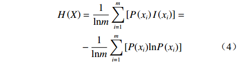
$$ \begin{split} H\left(X\right)&=\frac{1}{\mathrm{l}\mathrm{n}m}\sum _{i=1}^{m}\left[P\left({x}_{i}\right)I\left({x}_{i}\right)\right]=\\ &-\frac{1}{\mathrm{l}\mathrm{n}m}\sum _{i=1}^{m}\left[P({x}_{i})\mathrm{l}\mathrm{n}P\left({x}_{i}\right)\right] \end{split} $$ (4) 式中:
$I\left({x}_{i}\right) $ ——第i个因子情况下的$I\left({x}\right) $ 值;m——事件X发生的情况种数。
指标权重值:
$$ {W}_{i}=\frac{1-{H}_{i}}{n-\displaystyle\sum _{i=1}^{m}{H}_{i}} $$ (5) 式中:
${H}_{i} $ ——第i个因子的信息熵;n——评价因子的类别个数;
Wi——第i个因子的权重。
2.4 信息量模型
信息量(information value,IV)模型是由信息论发展而来的一种统计分析预测法,是统计模型和信息论结合并持续衍生发展而来的[15],其理论基础为贝叶斯法则[6]。IV模型的观点认为,灾害发生与多种影响因素有关,灾害的发生与预测过程中获得的信息数量及质量密切有关。通过对影响因子分级,分析统计各个影响因子等级对灾害发生的“贡献率”。叠加各因子“贡献率”,得到信息量,信息量值越大,则灾害发生的可能性越大。
滑坡灾害在各影响因素中的发生概率难以准确计算,因此在实际滑坡危险性评价中,采用对研究区划分基础评价单元后,采用样本频率计算各个评价因子条件下,基础评价单元的信息量值,计算公式如下:
$$ {I}_{i}=\ln\frac{{N}_{i}/N}{{S} _{i}/S} $$ (6) 式中:Ii——评价因子xi对滑坡贡献的信息量;
Ni——在评价因子xi中发生滑坡灾害的单元数或 灾害点;
N——研究区含有滑坡灾害的单元总数或灾害总数;
Si——研究区内含评价因子xi的单元数;
S——研究区评价单元的总数。
2.5 加权信息量模型
通过熵权法得到各评价因子的权重,再结合IV模型得到的各评价因子信息量值,最终得到加权信息量(WIV)值,计算如下:
$$ {I}_{a}=\sum _{i=1}^{m}{W}_{i}{I}_{i}=\sum _{i=1}^{m}{W}_{i}\ln\frac{{N}_{i}/N}{{S} _{i}/S} $$ (7) 式中:Ia——在n种评价因子组合条件下基础评价单元的 加权信息量。
3. 评价单元及评价因子选取
3.1 确定评价单元
选择合适的评价单元,可以有效的提升评价结果的精度。现滑坡灾害危险性评价常见的评价单元有斜坡单元、行政单元、栅格单元等[16]。由于栅格单元具有计算简单快捷,精度较高、数据信息库结构清晰的优点,本文采用栅格单元作为滑坡危险性评价的基本单元。栅格单元的网格尺寸选择也对评价结果起着重要作用,不同网格尺寸获得的评价因子数据精度不同,汤国安等[17]提出了栅格单元尺寸的经验公式:
$$ {G}_{f}=7.49+0.006f-2.0\times {10}^{-9}{f}^{2}+2.9\times {10}^{-15}{f}^{3} $$ (8) 式中:Gf ——合适的网格尺寸;
f——基础数据的比例尺。
本研究使用基础数据为1∶5万的DEM数据,代入式(8)进行计算求得栅格单元网格尺寸为Gf =29.976,本研究采用取整后的30 m×30 m栅格尺寸作为基础评价尺寸。
3.2 评价因子选取及分级
滑坡灾害的发生受多种因素的影响,主要受坡体内部基础地质条件和外部诱发因素共同作用。本文根据分析研究区实际调查的历史滑坡情况与研究区地形地质条件,对研究区滑坡发育主要影响因子进行筛选,最终选取高程、坡度、坡向、岩性、距断裂距离、植被覆盖度、距道路距离、降雨量共8个因素作为研究区滑坡危险性评价因子。利用GIS平台对各因子进行分级,并对滑坡在各因子分级间分布关系进行分析。
(1)高程:澜沧县地处云南高原横断山区,全县最高点位于中部麻栗黑山,海拔2530 m。域内高程492~2530 m,采用自然间断点法将其分为5个等级,见图2(a)。分析高程各分级与滑坡点密度关系,见图3(a),结果显示:滑坡发育总体上呈现出随高程的增加而增多,在1623~1910 m最为发育,在1910 m以上区域,居民分布少,人类活动及其强度较小。
![]() 图 3 指标分级与滑坡相对点密度柱状图Figure 3. Histogram of indicator classification and relative point density of landslide
图 3 指标分级与滑坡相对点密度柱状图Figure 3. Histogram of indicator classification and relative point density of landslide(2)坡度:区内山高谷深,研究区坡度范围为0~72.4°,按10°为间隔,将其重分类为5个等级,见图2(b)。分析坡度分级与滑坡相对点密度关系,见图3(b),结果表示:在>40°范围内,滑坡分布最密集,滑坡发生可能性大。
(3)坡向:将研究区坡向按方向分为8个等级,见图2(c)。分析坡向分级与滑坡相对点密度关系,见图3(c),结果表明在东北方向滑坡最为发育。
(4)地层岩性:将研究区地质岩组划分为5个等级,见图2(d):松散岩土体、软弱岩组、较软弱岩组、较坚硬岩组、坚硬岩组。分析地层岩性分级与滑坡分布系,见图3(d),结果表明:滑坡的发育总体呈现随着岩性坚硬程度的增加而减少。
(5)距断裂距离:澜沧县位于三江印支褶皱系的南延部分,经历多次强烈的构造运动,断裂构造发育。断裂为线状影响因子,为量化其对滑坡灾害的影响,对其按1 000 m间距建立缓冲区,将距断裂距离划分为5个等级,见图2(e)。分析断裂距离分级与滑坡分布关系,见图3(e),滑坡与断裂大体呈距离越近越易发生的趋势,分析在>4000 m范围内也较发育的原因主要是居民分布较多,人类工程活动影响较大。
(6)植被覆盖度:利用ENVI软件从Landsat 8 OLI-TIRS遥感影像中提取研究区植被覆盖度,其值范围为0~1,其值越大,表示植被覆盖度越高,在GIS中,按自然间断点进行重分类,见图2(f)。分析植被覆盖与滑坡分布关系,见图3(f),滑坡与植被覆盖呈植被越少滑坡越易发生的趋势,因植被越多,根系越发达,可稳固土体,增强土体稳定性。
(7)距道路距离:研究区属高原山区,道路建设活动频繁。以500 m间距为基础,将道路作缓冲区处理并分级,见图2(g)。分析道路距离分级与滑坡相对点密度关系,见图3(g),呈现出距道路越近滑坡发育越密集的趋势。
(8)降雨量:降雨量是诱发滑坡的主要触发因素[18]。以研究区年均降雨量为基础,按自然间断分级法将降雨量划分为5个等级,见图2(h)。分析降雨量分级与滑坡分布关系,见图3(h),滑坡相对点密度在总体上呈现出随降雨量的增大而降低,分析其原因为降雨量大的区域,植被也相对茂盛,对岩土有一定加固作用,其次,降雨量大的地区已经在生态演化中达到了一定的平衡,降低了降水对坡体的破坏作用。
4. 滑坡危险性评价
4.1 熵权法计算权重
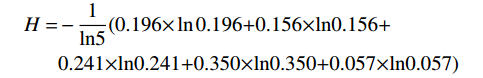
根据式(1)(2)计算滑坡灾害点相对点密度并进行标准化处理,结果代入式(4)计算各因子的信息熵值。例在高程范围为492~1099 m、1099~1366 m、1366~1623 m、1623~1910 m、1910~2530 m的相对点密度分别为:0.927、0.738、1.142、1.653、0.269,进行标准化处理后分别为:0.196,0.156,0.241,0.350,0.057。将标准化后的值Xi作为P(x)代入信息熵值计算公式中,得到高程的信息熵值计算为:
$$ \begin{split} {{H}}=&-\frac{{1}}{{\ln}{5}}(0.196{\times}\ln{0.196}{+0.156}{\times}{\ln}{0.156}+\\ &{0.241}{\times}{\ln}{0.241}{+0.350}{\times}{\ln}{0.350}{+0.057}{\times}{\ln}{0.057}) \end{split}$$ 同理,计算出高程、坡度、坡向、地层岩性、距断裂距离、植被覆盖度、距道路距离、降雨量的信息熵值H分别为0.921、0.984、0.967、0.911、0.971、0.897、0.950、0.947。
再将H值代入式(5)得到各因子的权值。结果见表2
表 2 指标统计计算结果Table 2. Statistical calculation results of indicators因子 因子二级属性 滑坡点个数 栅格数量 信息量 相对点密度 归一化Xi Hi Wi 高程/m 492~1 099 20 1 224 511 −0.076 0.927 0.196 0.921 0.174 1 099~1 366 33 2 536 591 −0.303 0.738 0.156 1 366~1 623 54 2 684 074 0.133 1.142 0.241 1 623~1 910 58 1 991 079 0.503 1.653 0.350 1 910~2 530 6 1 268 180 −1.315 0.269 0.057 坡度/(°) 0~10 24 1 453 076 −0.065 0.937 0.171 0.984 0.034 10~20 75 3 730 552 0.132 1.141 0.208 20~30 47 3 223 642 −0.189 0.827 0.151 30~40 20 1 114 820 0.018 1.018 0.186 >40 5 182 345 0.442 1.556 0.284 坡向 北 18 1 267 813 −0.216 0.806 0.102 0.967 0.072 东北 38 1 404 853 0.429 1.535 0.195 东 9 1 199 159 −0.853 0.426 0.054 东南 14 1 116 898 −0.341 0.711 0.090 南 29 1 195 808 0.319 1.376 0.175 西南 25 1 283 120 0.101 1.106 0.140 西 14 1 112 242 −0.336 0.714 0.091 西北 24 1 124 542 0.192 1.211 0.154 地层岩性 松散岩(土)体 3 91 136 0.625 1.868 0.306 0.911 0.197 软弱岩层 7 197 943 0.697 2.007 0.329 较软弱岩层 30 2 174 744 −0.245 0.783 0.128 较坚硬岩层 128 6 776 327 0.070 1.072 0.176 坚硬岩层 3 464 285 −1.003 0.367 0.060 距断裂距离/m 0~1 000 44 1 912 260 0.267 1.306 0.282 0.971 0.065 1 000~2 000 29 1574 153 0.044 1.046 0.226 2 000~3 000 16 1 187 454 −0.268 0.765 0.165 3 000~4 000 8 917 368 −0.703 0.495 0.107 >4 000 74 4 113 200 0.021 1.021 0.220 植被覆盖度 0~0.19 33 900 995 0.732 2.079 0.329 0.897 0.228 0.19~0.45 45 1 291 011 0.682 1.978 0.313 0.45~0.66 38 1 846 666 0.155 1.168 0.185 0.66~0.84 41 2 895 125 −0.219 0.804 0.127 0.84~0.1 14 2 770 638 −1.249 0.287 0.045 距道路距离/m 0~500 19 480 354 0.809 2.245 0.358 0.950 0.111 500~1 000 11 458 280 0.309 1.362 0.217 1 000~1 500 7 433 124 −0.086 0.917 0.146 1 500~2 000 6 413 798 −0.195 0.823 0.131 >2 000 128 7 918 879 −0.086 0.917 0.146 降雨量/mm 1 212.3~1 313.2 41 1 166 233 0.691 1.995 0.356 0.947 0.119 1 313.2~1 382.0 35 1 524 128 0.265 1.303 0.233 1 382.0~1 435.2 27 1 962 908 −0.248 0.781 0.139 1 435.2~1 485.8 38 2 637 049 −0.201 0.818 0.146 1 485.8~1 545.5 30 2 414 117 −0.349 0.705 0.126 4.2 加权信息量计算
通过式(6)计算出各评价因子二级属性下的信息量,结果见表2。利用GIS栅格计算器,将熵权法所得到的权重与信息量值按式(7)方式进行加权叠加求和,得到各个栅格最终的加权信息量值。最后,采用自然间断点法进行滑坡高、较高、中、低危险性区四个等级的划分。
5. 评价结果分析与检验
5.1 结果分析
统计危险性等级划分后的面积及面积占比及各等级内滑坡灾害点数量见表3,从危险性分区结果得出,研究区滑坡灾害高危险区域主要集中在研究区北部、西北部及东部边界临近河流区域,主要为雪林乡、木戛乡、安康乡、文东乡、上允镇等人类活动强度大,交通经济发达区域,与实际中滑坡灾害的分布相吻合。较高危险区域主要分布在研究区东部及南部区域,较为分散。中、低危险区主要分布在研究区中部及东南部部分区域(图4)。
表 3 分区统计结果Table 3. Statistical results of zoning危险性等级 面积/km2 面积
比例/%滑坡点
/个滑坡点
比例/%滑坡相对
点密度高危险区 1549.72 17.91 84 49.12 2.74 较高危险区 3280.77 37.91 63 36.84 0.97 中危险区 2244.93 25.94 19 11.11 0.43 低危险区 1579.76 18.25 5 2.92 0.16 高危险性及较高危险性区域的地质环境表现出多个特点。首先,植被覆盖度较低,土体稳定性低于高植被覆盖区域。因植被可以固定土壤,减少水土流失,提高土体的稳定性。其次,工程岩组以松散岩土和较软岩组为主,为滑坡的发育提供了物质基础。松散的岩土容易受到水流、风化等自然因素的影响,导致岩土体的破坏和滑动。第三,处于高海拔、坡度较陡、距离断裂较近地带,且主要集中在人类生活活动区域,地形地貌受到严重破坏。因此,在进行区域规划和开发时,需充分考虑上述地质环境特点,采取相应的措施减少滑坡灾害风险。
5.2 合理性检验
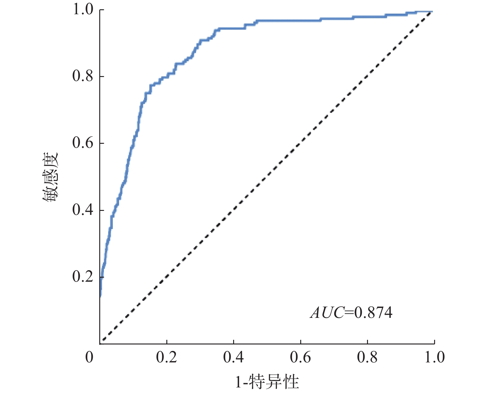
本研究采用受试者工作特征曲线(ROC曲线)对本文滑坡危险性评价结果进行验证。该方法以真阳性率为纵坐标,以假阳性率为横坐标,形成曲线,曲线下的面积(AUC)用来预测结果合理性,其值越大,则越合理,一般,AUC值在0.7~0.9间,则说明结果具有较高的合理性,当AUC的值大于0.9时,则说明合理性最好[19]。本文以研究区滑坡灾害点数据作为基础,结合随机选取的非灾害点,分别对灾害点及非灾害点的加权信息量数据进行提取,将灾害点数据目标值设为1,非灾害点数据目标值设为0。把处理好的数据导入SPSS软件中进行运算,得到本次危险性评价的ROC曲线图5,由计算结果得,AUC值为0.874,证明危险性评价结果具有较好的合理性。
6. 结论及讨论
6.1 结论
(1)文中构建研究区滑坡危险评价指标体系并分析滑坡与因子间分布关系,区域内滑坡多发育在高程范围1623~1910 m、坡度范围>40°、东北及南坡向、较软岩层及植被覆盖度低区域,且呈现出随距离断裂带、道路越近滑坡越发育的趋势。
(2)采用熵权法对滑坡评价因子进行权重计算,结果表示:植被覆盖、地层岩性、高程、降雨量是影响研究区滑坡灾害发育最主要的4个因素。耦合信息量模型对区域滑坡危险性进行评价并区划为4类危险区域:高危险区(1549.72 km2)、较高危险区(3280.77 km2)、中危险区(2244.93 km2)、低危险区(1579.76 km2),高和较高危险性区域占总面积55.82%,其中滑坡占总数86%。
(3)采用ROC曲线对本文评价结果进行检验,得到AUC值为0.874,合理性较高,熵权法与信息量耦合的加权信息量模型在滑坡危险性评价中有较好的适用性及科学性。
6.2 讨论
(1)滑坡危险性评价是现代灾害的一项研究热点,滑坡评价因子权重分析是其中重点。本文采用客观赋值的熵权法对评价因子进行权重计算,避免了人为主观影响,客观性强,计算结果有较好的解释性。
(2)研究内容受现有资料限制,数据多源,无法保证精度的统一,分析精度上还有提升空间。相关数据的更新滞后于当前滑坡情况,在数据处理上有待挖掘更好的方法,以减少数据滞后带来的结果差异。
(3)滑坡灾害在时间和空间上具有不确定性、突发性,且破坏性大,本文仅对其危险性进行分析,后续还可在发育规律及特征上开展研究。
-
![]()
图 1 研究区位置与滑坡灾害点分布
Figure 1. Location of the study area and distribution of landslide hazard sites
![]()
图 3 指标分级与滑坡相对点密度柱状图
Figure 3. Histogram of indicator classification and relative point density of landslide
表 1 数据来源
Table 1 Summary of data source
数据名称 数据来源 数据名称 数据来源 滑坡灾害点 澜沧县地质灾害详查 DEM数据 地理空间数据云 地质图 全国地质资料馆 降雨量 中国气象数据网 道路数据 91卫图助手 植被覆盖数据 地理空间数据云  下载: 导出CSV
表 2 指标统计计算结果
Table 2 Statistical calculation results of indicators
因子 因子二级属性 滑坡点个数 栅格数量 信息量 相对点密度 归一化Xi Hi Wi 高程/m 492~1 099 20 1 224 511 −0.076 0.927 0.196 0.921 0.174 1 099~1 366 33 2 536 591 −0.303 0.738 0.156 1 366~1 623 54 2 684 074 0.133 1.142 0.241 1 623~1 910 58 1 991 079 0.503 1.653 0.350 1 910~2 530 6 1 268 180 −1.315 0.269 0.057 坡度/(°) 0~10 24 1 453 076 −0.065 0.937 0.171 0.984 0.034 10~20 75 3 730 552 0.132 1.141 0.208 20~30 47 3 223 642 −0.189 0.827 0.151 30~40 20 1 114 820 0.018 1.018 0.186 >40 5 182 345 0.442 1.556 0.284 坡向 北 18 1 267 813 −0.216 0.806 0.102 0.967 0.072 东北 38 1 404 853 0.429 1.535 0.195 东 9 1 199 159 −0.853 0.426 0.054 东南 14 1 116 898 −0.341 0.711 0.090 南 29 1 195 808 0.319 1.376 0.175 西南 25 1 283 120 0.101 1.106 0.140 西 14 1 112 242 −0.336 0.714 0.091 西北 24 1 124 542 0.192 1.211 0.154 地层岩性 松散岩(土)体 3 91 136 0.625 1.868 0.306 0.911 0.197 软弱岩层 7 197 943 0.697 2.007 0.329 较软弱岩层 30 2 174 744 −0.245 0.783 0.128 较坚硬岩层 128 6 776 327 0.070 1.072 0.176 坚硬岩层 3 464 285 −1.003 0.367 0.060 距断裂距离/m 0~1 000 44 1 912 260 0.267 1.306 0.282 0.971 0.065 1 000~2 000 29 1574 153 0.044 1.046 0.226 2 000~3 000 16 1 187 454 −0.268 0.765 0.165 3 000~4 000 8 917 368 −0.703 0.495 0.107 >4 000 74 4 113 200 0.021 1.021 0.220 植被覆盖度 0~0.19 33 900 995 0.732 2.079 0.329 0.897 0.228 0.19~0.45 45 1 291 011 0.682 1.978 0.313 0.45~0.66 38 1 846 666 0.155 1.168 0.185 0.66~0.84 41 2 895 125 −0.219 0.804 0.127 0.84~0.1 14 2 770 638 −1.249 0.287 0.045 距道路距离/m 0~500 19 480 354 0.809 2.245 0.358 0.950 0.111 500~1 000 11 458 280 0.309 1.362 0.217 1 000~1 500 7 433 124 −0.086 0.917 0.146 1 500~2 000 6 413 798 −0.195 0.823 0.131 >2 000 128 7 918 879 −0.086 0.917 0.146 降雨量/mm 1 212.3~1 313.2 41 1 166 233 0.691 1.995 0.356 0.947 0.119 1 313.2~1 382.0 35 1 524 128 0.265 1.303 0.233 1 382.0~1 435.2 27 1 962 908 −0.248 0.781 0.139 1 435.2~1 485.8 38 2 637 049 −0.201 0.818 0.146 1 485.8~1 545.5 30 2 414 117 −0.349 0.705 0.126
下载: 导出CSV
表 3 分区统计结果
Table 3 Statistical results of zoning
危险性等级 面积/km2 面积
比例/%滑坡点
/个滑坡点
比例/%滑坡相对
点密度高危险区 1549.72 17.91 84 49.12 2.74 较高危险区 3280.77 37.91 63 36.84 0.97 中危险区 2244.93 25.94 19 11.11 0.43 低危险区 1579.76 18.25 5 2.92 0.16
下载: 导出CSV
-
[1] 李益敏,袁静,蒋德明,等. 基于GIS的西南高山峡谷区滑坡风险性评价—以怒江州泸水市为例[J]. 西北师范大学学报(自然科学版),2021,57(6):94 − 102. [LI Yimin,YUAN Jing,JIANG Deming,et al. Risk assessment of landslide disasters in alpine canyon area based on GIS:Taking Lushui City,Nujiang Prefecture as an example[J]. Journal of Northwest Normal University (Natural Science),2021,57(6):94 − 102. (in Chinese with English abstract) LI Yimin, YUAN Jing, JIANG Deming, et al. Risk assessment of landslide disasters in alpine canyon area based on GIS—taking Lushui City, Nujiang Prefecture as an example[J]. Journal of Northwest Normal University (Natural Science), 2021, 57(6): 94-102. (in Chinese with English abstract)
[2] 屠水云,张钟远,付弘流,等. 基于CF与CF-LR模型的地质灾害易发性评价[J]. 中国地质灾害与防治学报,2022,33(2):96 − 104. [TU Shuiyun,ZHANG Zhongyuan,FU Hongliu,et al. Geological hazard susceptibility evaluation based on CF and CF-LR model[J]. The Chinese Journal of Geological Hazard and Control,2022,33(2):96 − 104. (in Chinese with English abstract) DOI: 10.16031/j.cnki.issn.1003-8035.2022.02-12 TU Shuiyun, ZHANG Zhongyuan, FU Hongliu, et al. Geological hazard susceptibility evaluation based on CF and CF-LR model[J]. The Chinese Journal of Geological Hazard and Control, 2022, 33(2): 96-104. (in Chinese with English abstract) DOI: 10.16031/j.cnki.issn.1003-8035.2022.02-12
[3] 杨华阳,许向宁,杨鸿发. 基于证据权法的九寨沟地震滑坡危险性评价[J]. 中国地质灾害与防治学报,2020,31(3):20 − 29. [YANG Huayang,XU Xiangning,YANG Hongfa. The Jiuzhaigou co-seismic landslide hazard assessment based on weight of evidence method[J]. The Chinese Journal of Geological Hazard and Control,2020,31(3):20 − 29. (in Chinese with English abstract) DOI: 10.16031/j.cnki.issn.1003-8035.2020.03.03 YANG Huayang, XU Xiangning, YANG Hongfa. The Jiuzhaigou co-seismic landslide hazard assessment based on weight of evidence method[J]. The Chinese Journal of Geological Hazard and Control, 2020, 31(3): 20-29. (in Chinese with English abstract) DOI: 10.16031/j.cnki.issn.1003-8035.2020.03.03
[4] 管新邦. 云南省滑坡地质灾害危险性评价研究[D]. 北京: 中国矿业大学(北京), 2018 GUAN Xinbang. Study on risk assessment of landslide geological hazards in Yunnan Province[D]. Beijing: China University of Mining & Technology, Beijing, 2018. (in Chinese with English abstract)
[5] 孙长明,马润勇,尚合欣,等. 基于滑坡分类的西宁市滑坡易发性评价[J]. 水文地质工程地质,2020,47(3):173 − 181. [SUN Changming,MA Runyong,SHANG Hexin,et al. Landslide susceptibility assessment in Xining based on landslide classification[J]. Hydrogeology & Engineering Geology,2020,47(3):173 − 181. (in Chinese with English abstract) SUN Changming, MA Runyong, SHANG Hexin, et al. Landslide susceptibility assessment in Xining based on landslide classification[J]. Hydrogeology & Engineering Geology, 2020, 47(3): 173-181. (in Chinese with English abstract)
[6] 温鑫,范宣梅,陈兰,等. 基于信息量模型的地质灾害易发性评价—以川东南古蔺县为例[J]. 地质科技通报,2022,41(2):290 − 299. [WEN Xin,FAN Xuanmei,CHEN Lan,et al. Susceptibility assessment of geological disasters based on an information value model:A case of Gulin County in southeast Sichuan[J]. Bulletin of Geological Science and Technology,2022,41(2):290 − 299. (in Chinese with English abstract) WEN Xin, FAN Xuanmei, CHEN Lan, et al. Susceptibility assessment of geological disasters based on an information value model: a case of Gulin County in Southeast Sichuan[J]. Bulletin of Geological Science and Technology, 2022, 41(2): 290-299. (in Chinese with English abstract)
[7] 申怀飞,董雨,杨梅,等. 基于AHP与信息量法的甘肃省滑坡易发性评估[J]. 水土保持研究,2021,28(6):412 − 419. [SHEN Huaifei,DONG Yu,YANG Mei,et al. Assessment on landslide susceptibility in Gansu Province based on AHP and information quantity method[J]. Research of Soil and Water Conservation,2021,28(6):412 − 419. (in Chinese with English abstract) DOI: 10.13869/j.cnki.rswc.2021.06.034 SHEN Huaifei, DONG Yu, YANG Mei, et al. Assessment on landslide susceptibility in Gansu Province based on AHP and information quantity method[J]. Research of Soil and Water Conservation, 2021, 28(6): 412-419. (in Chinese with English abstract) DOI: 10.13869/j.cnki.rswc.2021.06.034
[8] 孙滨,祝传兵,康晓波,等. 基于信息量模型的云南东川泥石流易发性评价[J]. 中国地质灾害与防治学报,2022,33(5):119 − 127. [SUN Bin,ZHU Chuanbing,KANG Xiaobo,et al. Susceptibility assessment of debris flows based on information model in Dongchuan,Yunnan Province[J]. The Chinese Journal of Geological Hazard and Control,2022,33(5):119 − 127. (in Chinese with English abstract) DOI: 10.16031/j.cnki.issn.1003-8035.202204003 SUN Bin, ZHU Chuanbing, KANG Xiaobo, et al. Susceptibility assessment of debris flows based on information model in Dongchuan, Yunnan Province[J]. The Chinese Journal of Geological Hazard and Control, 2022, 33(5): 119-127. (in Chinese with English abstract) DOI: 10.16031/j.cnki.issn.1003-8035.202204003
[9] 杜国梁,杨志华,袁颖,等. 基于逻辑回归-信息量的川藏交通廊道滑坡易发性评价[J]. 水文地质工程地质,2021,48(5):102 − 111. [DU Guoliang,YANG Zhihua,YUAN Ying,et al. Landslide susceptibility mapping in the Sichuan-Tibet traffic corridor using logistic regression-information value method[J]. Hydrogeology & Engineering Geology,2021,48(5):102 − 111. (in Chinese with English abstract) DU Guoliang, YANG Zhihua, YUAN Ying, et al. Landslide susceptibility mapping in the Sichuan-Tibet traffic corridor using logistic regression-information value method[J]. Hydrogeology & Engineering Geology, 2021, 48(5): 102-111. (in Chinese with English abstract)
[10] 王夏林,严宝文. 基于熵权的可拓理论在地灾危险性评价中的应用[J]. 人民长江,2012,43(21):70 − 74. [WANG Xialin,YAN Baowen. Application of entropy weight based extension theory in risk assessment of geological hazards[J]. Yangtze River,2012,43(21):70 − 74. (in Chinese with English abstract) DOI: 10.3969/j.issn.1001-4179.2012.21.019 WANG Xialin, YAN Baowen. Application of entropy weight based extension theory in risk assessment of geological hazards[J]. Yangtze River, 2012, 43(21): 70-74. (in Chinese with English abstract) DOI: 10.3969/j.issn.1001-4179.2012.21.019
[11] 周苏华,付宇航,徐智文,等. 基于主客观赋权法的福建省地质灾害易发性评价[J]. 安全与环境学报,2022,23(9):3204 − 3214. [ZHOU Suhua,FU Yuhang,XU Zhiwen,et al. Evaluation of geological disaster susceptibility in Fujian Province based on subjective and objective weighting method[J]. Journal of Safety and Environment,2022,23(9):3204 − 3214. (in Chinese with English abstract) Zhou Suhua, Fu Yuhang, Xu Zhiwen, et al. Evaluation of geological disaster susceptibility in Fujian Province based on subjective and objective weighting method [J]. Journal of Safety and Environment, 2022: 1-12. (in Chinese with English abstract)
[12] KHATUN M,HOSSAIN A T M S,SAYEM H M,et al. Landslide susceptibility mapping using weighted-overlay approach in rangamati,Bangladesh[J]. Earth Systems and Environment,2023,7(1):223 − 235. DOI: 10.1007/s41748-022-00312-2
[13] CHEN W,CHAI H C,SUN X Y,et al. A GIS-based comparative study of frequency ratio,statistical index and weights-of-evidence models in landslide susceptibility mapping[J]. Arabian Journal of Geosciences,2016,9(3):204. DOI: 10.1007/s12517-015-2150-7
[14] 刘福臻,王灵,肖东升,等. 基于模糊综合评判法的宁南县滑坡易发性评价[J]. 自然灾害学报,2021,30(5):237 − 246. [LIU Fuzhen,WANG Ling,XIAO Dongsheng,et al. Evaluation of landslide susceptibility in Ningnan County based on fuzzy comprehensive evaluation[J]. Journal of Natural Disasters,2021,30(5):237 − 246. (in Chinese with English abstract) LIU Fuzhen, WANG Ling, XIAO Dongsheng, et al. Evaluation of landslide susceptibility in Ningnan County based on fuzzy comprehensive evaluation[J]. Journal of Natural Disasters, 2021, 30(5): 237-246. (in Chinese with English abstract)
[15] 罗亮,宋国虎,唐良琴,等. 白龙江武都区段泥石流分布规律及其危险性评价[J]. 人民长江,2022,53(5):135 − 142. [LUO Liang,SONG Guohu,TANG Liangqin,et al. Debris flow distribution law and risk analysis in Wudu section of Bailong River[J]. Yangtze River,2022,53(5):135 − 142. (in Chinese with English abstract) LUO Liang, SONG Guohu, TANG Liangqin, et al. Debris flow distribution law and risk analysis in Wudu section of Bailong River[J]. Yangtze River, 2022, 53(5): 135-142.(in Chinese with English abstract)
[16] 崔阳阳. 基于不同评价单元的滑坡易发性评价方法研究—以陕西省洛南县为例[D]. 西安: 西安科技大学, 2022 CUI Yangyang. Study on evaluation method of landslide susceptibility based on different evaluation units: A case study of Luonan County, Shaanxi Province[D]. Xi’an: Xi’an University of Science and Technology, 2022. (in Chinese with English abstract)
[17] 汤国安, 刘学军, 闾国年.数字高程模型及地学分析的原理与方法[M]. 科学出版社, 2005 TANG Guoan, LIU Xuejun, LU Guonian. Principles and methods of digital elevation model and geoscience analysis[M]. Science Press, 2005. (in Chinese )
[18] 朱晓霞,张力,杨树文. 降雨引发的兰州黄土滑坡时空规律分析和临界降雨量预测[J]. 中国地质灾害与防治学报,2019,30(4):24 − 31. [ZHU Xiaoxia,ZHANG Li,YANG Shuwen. Characteristics of rainfall-induced loess landslides and their threshold rainfall in Lanzhou[J]. The Chinese Journal of Geological Hazard and Control,2019,30(4):24 − 31. (in Chinese with English abstract) DOI: 10.16031/j.cnki.issn.1003-8035.2019.04.04 ZHU Xiaoxia, ZHANG Li, YANG Shuwen. Characteristics of rainfall-induced loess landslides and their threshold rainfall in Lanzhou[J]. The Chinese Journal of Geological Hazard and Control, 2019, 30(4): 24-31. (in Chinese with English abstract) DOI: 10.16031/j.cnki.issn.1003-8035.2019.04.04
[19] 韩玲,张庭瑜,张恒. 基于IOE和SVM模型的府谷镇滑坡易发性分区[J]. 水土保持研究,2019,26(3):367 − 372. [HAN Ling,ZHANG Tingyu,ZHANG Heng. Landslide susceptibility mapping based on IOE and SVM model in Fugu Town[J]. Research of Soil and Water Conservation,2019,26(3):367 − 372. (in Chinese with English abstract) HAN Ling, ZHANG Tingyu, ZHANG Heng. Landslide susceptibility mapping based on IOE and SVM model in Fugu town[J]. Research of Soil and Water Conservation, 2019, 26(3): 367-372. (in Chinese with English abstract)
-
期刊类型引用(1)
1. 宋银,陈亮,王研,何清,杨林,巴净慧,陈典. 云南德钦县一中河泥石流成灾特征及危险性评价. 中国地质灾害与防治学报. 2024(05): 103-109 .  本站查看
本站查看
其他类型引用(1)


计量
- 文章访问数: 1170
- HTML全文浏览量: 1851
- PDF下载量: 238
- 被引次数: 2
 邮件订阅
邮件订阅 RSS
RSS