

Effect of sample selection on the susceptibility assessment of geological hazards: A case study in Liulin County, Shanxi Province
-
摘要:
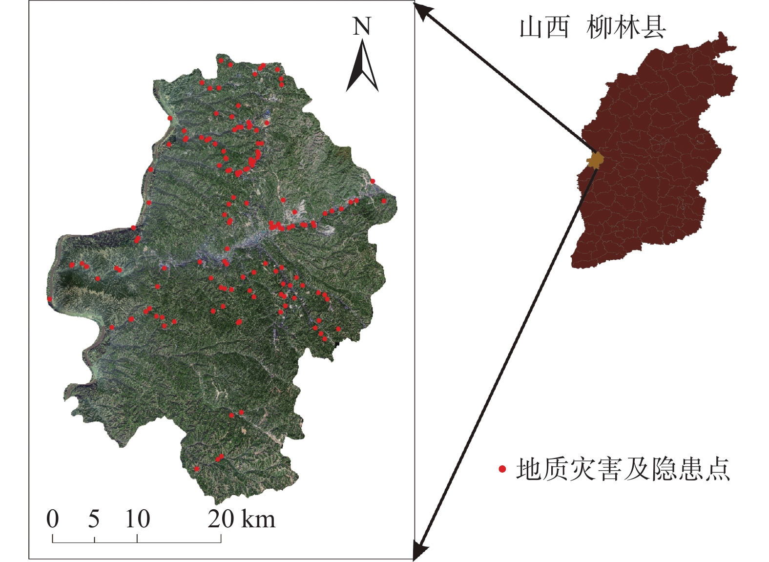
非地质灾害样本的合理选取对地质灾害易发性预测准确度的提高具有重要意义。文章以柳林县为例,选取适宜的影响因子,基于GIS技术采用随机森林模型进行易发性评价。以地质灾害与非地质灾害比例为1∶1、1∶1.5、1∶3、1∶5、1∶10和非地质灾害点距已知灾害点100,500,800,1000 m为选取条件交叉结合共创建20组模型进行分析。结果表明:(1)通过误差指标、混淆矩阵和ROC曲线检验,样本比例和距已知灾害点距离变化对地质灾害易发性评价结果有较大影响。随着样本比例变小,距已知灾害点距离增加,各模型平均绝对误差和均方根误差整体下降,准确率整体上升。各模型ROC曲线下面积值均大于0.8,均有较好的预测效果。当样本比例小于1∶3时,距已知灾害点距离增加对模型误差和准确率影响较小,变化趋于稳定。综合判断样本比例为1∶10、距已知灾害点1000 m为最适合研究区模型。(2)高和极高易发区主要分布在中部及北部道路和河流两侧的地区,是柳林县防灾减灾的重点区。(3)样本选取差异导致易发性结果不同主要是因为建模过程中随机森林模型对数据特征的采集及判断发生变化,样本是否具有代表性发生变化。这些研究成果对当防灾减灾工作的实施具有重要意义。
Abstract:The rational selection of non-geological hazard samples is of great significance to improve the accuracy of geological hazard susceptibility prediction. This study uses Liulin County as a case study, where appropriate impact factors were selected, and the random forest (RF) model was employed for susceptibility assessment based on GIS technology. A total of twenty sets of models were created by varying the ratio of geological hazard to non-geological hazard points (1∶1, 1∶1.5, 1∶3, 1∶5 and 1∶10) and the distance from non-geological hazard points to known hazard points (100,500,800,1000 m). The results demonstrate that: (1) Through error index, confusion matrix, and ROC curve tests, the sample proportion and distance from the known hazard point significantly influenced the geological hazard susceptibility evaluation. As the sample proportion decreased and the distance from known hazard points increased, the overall MAE and RMSE of the models decreased, while the overall ACC increased. All models achieved AUC value greater than 0.8, indicating excellent predictive performance. When the sample proportion was less than 1∶3, the increasing distance from the known hazard points on model error and accuracy became less pronounced, stabilizing the results. The most suitable model for the study area was found to have a sample ratio of 1∶10 and a distance of 1000 m from known hazard points. (2) High and very high susceptibility areas were primarily located in the central and northern regions, adjacent to roads and rivers, making them key areas for hazard prevention and reduction in Liulin County. (3) Differences in sample selection led to varying susceptibility results mainly due to changes in the RF model's data feature collection and judgment during the modeling process, as well as the representativeness of the samples. These research findings hold significant implications for the implementation of hazard prevention and reduction measures.
-
Keywords:
- non-geological hazard /
- GIS /
- random forest /
- susceptibility /
- error /
- confusion matrix /
- ROC
-
0. 引 言
据不完全统计我国共有露天煤矿约300座(不含井露联合开采煤矿),产能达7.5908×10⁸ t/a[1]。露天矿山边坡失稳滑坡会直接威胁到矿山工作者的生命和财产安全[2],由若干台阶构成的边坡也是露天矿山生产运输的主要依托对象,露天边坡稳定性直接影响到露天矿山的建设和生产。露天矿边坡稳定性分析一直是岩土工程领域研究的热点问题,一方面,露天矿边坡往往受多种影响因素共同作用,关系复杂[3]。另一方面,试验室难以还原现场地质条件及其他因素的影响,试验室岩样数据往往不能直接用于矿山边坡稳定性分析,所以作为露天矿边坡稳定性计算及数值模拟中岩(土)体的参数取值具有很大的模糊性,导致露天矿边坡是一个不确定性的系统,其稳定性评价也是一个不确定、多因素、非线性问题[4]。
针对露天矿边坡稳定性评价问题的不确定性、复杂性,一些学者将模糊评价理论等不确定性分析方法应用到边坡稳定性分析中。蒋中明[5]通过对边坡刚体极限平衡分析中模糊因素的分析, 提出了一种使用模糊集理论计算工程边坡稳定性的方法。丁浩江等[6]、王华俊等[7]分别运用模糊综合评价模型对澜沧江某水电站泄洪洞出口边坡和宁波市国省道公路岩质边坡进行了稳定性评价,评价结果均与实际情况吻合较好,验证了模糊综合评价方法运用于边坡稳定性分析的有效性。由于不同影响因素对边坡稳定性的影响不同,模糊综合评价方法中边坡影响因素权重的确定存在主观性,因此先采用层次分析法客观确定不同因素对边坡稳定性的影响权重进而采用模糊综合评价法对边坡稳定性进行评价效果会更好[8 − 9]。但是目前边坡稳定性分析的层次分析-模糊综合评价模型的评价指标主要来自边坡地质调查和边坡基本形态。已有研究中,将边坡变形监测信息作为评价指标纳入到该模型中的研究相对较少;此外已有研究主要通过现场观察边坡是否稳定来验证模型,这种模型验证方法存在一定的主观性。
基于此,本文建立了考虑边坡监测信息的层次分析-模糊综合评价模型,首先对边坡监测数据进行分析,然后将边坡监测信息纳入边坡层次分析-模糊综合评价模型中,同边坡几何形态、边坡地质信息、气象水文信息等构成边坡系统的评价指标,然后基于层次分析法确定边坡稳定性评价指标的权重,最后基于隶属度最大原则确定边坡稳定性状态。将建立的层次分析-模糊综合评价模型应用于扎哈淖尔露天煤矿北帮边坡稳定性评价,综合得出北帮边坡稳定性状况,最后通过数值模拟求解边坡安全系数对模型评价结果进行验证。
1. 边坡层次分析-模糊综合评价模型
模糊综合评价法对于复杂及不确定系统的评价具有明显的优势,将模糊综合评价法应用于边坡稳定性分析中首先需要确定边坡模糊指标集和评价集,然后根据隶属度函数确定单因子评价矩阵,根据边坡指标权重进行赋值,最后将权重向量与评价矩阵相结合根据隶属度最大原则得到最终的边坡稳定性评价结果[10 − 12]。
1.1 边坡模糊综合评价指标体系
根据相关规范[12],边坡的稳定性可以分为稳定、基本稳定、欠稳定、不稳定4个级别,同时建立边坡几何形态、边坡地质信息、边坡气象水文信息、边坡监测信息等四类边坡一级影响指标。边坡几何形态包括边坡坡高、边坡坡度、边坡结构类型3类指标;边坡地质信息包括边坡岩性、边坡弱层2项评价指标,边坡气象水文信息包括地下水影响、年平均降雨量2项评价指标;边坡监测信息主要包括地面变形情况、边坡变形速率等评价指标。边坡评价指标共9项,其中定量指标4项,定性指标5项。参考规范及已有研究[12 − 13]确定影响等级如表1和表2所示。
表 1 连续型指标影响等级划分Table 1. Classification of impact levels for continuous influencing indicators稳定性 坡高/m 坡度/(°) 年均降雨量/mm 地表变形
速率/(mm·d−1)稳定 0~100 0~15 0~500 5 基本稳定 >100~200 >15~30 >500~800 >5~30 欠稳定 >200~300 >30~50 >800~1200 >30~80 不稳定 >300 >50 >1200 >80 表 2 离散型指标影响等级划分Table 2. Classification of impact levels for discrete influencing indicators稳定性 岩性 结构类型 弱层 地面变形 地下水影响 稳定 坚硬岩体 均质/反倾 无 无 很弱 基本稳定 中等坚硬 斜交/横坡 反倾夹层 弱 较弱 欠稳定 软弱岩体 近水平坡 顺倾夹层、
反倾基岩中等 较强 不稳定 松散体 顺向坡 顺倾基岩 强烈 很强 1.2 层次分析法
对于露天矿边坡而言,各评价指标对边坡稳定性评价的贡献度是不同的,因此有必要利用层次分析法确定边坡各评价指标的影响因子[14]。通过标度方法,将影响因子的重要程度定量化[15]。如表3所示,通过指标两两比较后得出最终的边坡评价指标排序,表3中
标度 含义 1 3 5 7 9 2,4,6,8 介于以上两种比较之间的标度值 倒数 1.3 模型隶属度函数
隶属函数的确定对于边坡模糊综合评价具有重要的意义,隶属函数值即隶属度是表征边坡评价因子隶属于某个评价等级的程度。对于定量因素采用三角隶属度分布函数,本文采用的三角隶属度函数式(1)—(3)[17 − 18]。离散型指标隶属度的确定取值见表4[9, 13]。考虑到各个评价指标在边坡稳定性评价中的贡献不同,采用层次分析法将各项评价指标赋予一定的权重值,通过标度方法,将评价因子的重要程度定量化。
表 4 离散型指标评价隶属度表Table 4. Discrete index evaluation membership degree离散型指标 具体指标 离散型指标评价隶属度 稳定 基本稳定 欠稳定 不稳定 岩性 坚硬岩体 0.8 0.2 0 0 中等坚硬 0.4 0.5 0.1 0 软弱岩体 0 0.2 0.5 0.3 松散体 0 0 0.2 0.8 结构类型 顺向坡 0 0 0.2 0.8 近水平坡 0.1 0.2 0.7 0 斜交/横坡 0.2 0.7 0.1 0 均质/反倾 0.8 0.2 0 0 弱层 无 1 0 0 0 反倾夹层 0.2 0.7 0.1 0 顺倾夹层、反倾基岩 0 0.1 0.7 0.2 顺倾基岩 0 0 0.2 0.8 地面变形 无 0.8 0.2 0 0 弱 0.2 0.7 0.1 0 中等 0 0.1 0.7 0.2 强烈 0 0 0.2 0.8 地下水影响 很弱 0.55 0.30 0.10 0.05 较弱 0.25 0.50 0.15 0.10 较强 0.05 0.10 0.30 0.55 很强 0.05 0.15 0.10 0.70 (1) (2) (3) 式中:
2. 层次分析-模糊综合评价模型应用
2.1 工程概况
扎哈淖尔露天煤矿位于内蒙古自治区通辽市西北端,露天矿北帮于2020年5月出现明显的变形现象,边坡上部940水平及920水平出现明显裂隙,采场下部边坡850水平出现明显的大块岩体剪出现象,图1为扎哈淖尔露天矿的俯瞰图及现场图。沿边坡倾向方向选取研究剖面(图2),NO.1和NO.2为布置在剖面上的微变监测雷达监测特征点,露天矿北帮岩(土)层剖面如图3所示,北帮岩体整体倾向为逆倾、倾角5°~13°,边坡高度为234 m,坡度为16°,自上而下依次为第四系岩层、新近系和古近系岩层、泥岩、泥砂岩互层及煤层。经过现场勘探北帮850水平存在一层弱层,弱层厚度在1~2 m,钻孔岩芯(图4)显示弱层附近岩体较破碎。同时北帮边坡泥岩和第四系黏土中有出水点[20 − 21]。
![]() 图 2 扎哈淖尔露天矿北帮研究剖面位置Figure 2. Study cross-section at the north slope at Zhahanaoer open-pit mine
图 2 扎哈淖尔露天矿北帮研究剖面位置Figure 2. Study cross-section at the north slope at Zhahanaoer open-pit mine![]() 图 3 扎哈淖尔露天矿北帮地质剖面Figure 3. Geological cross-section of the north slope of open-pit mine
图 3 扎哈淖尔露天矿北帮地质剖面Figure 3. Geological cross-section of the north slope of open-pit mine![]() 图 4 扎哈淖尔露天矿北帮弱层岩芯Figure 4. Core samples of weak layers on the northern slope of open-pit mine
图 4 扎哈淖尔露天矿北帮弱层岩芯Figure 4. Core samples of weak layers on the northern slope of open-pit mine2.2 基于层次分析-模糊综合评价模型的边坡稳定性评价
根据现场勘察及收集已有的矿山地质资料,确定边坡高度为234 m,坡度为16°,年平均降雨量为354.3 mm,边坡变形速率取目前NO.1点和NO.2点监测数据的平均值,根据现场监测取值为24 mm/d,对于折减系数的取值,基于安全的角度,边坡模糊综合评价中的折减系数选取数值计算所得的较低值(1.121),定量指标采用三角形隶属度函数确定(表5)。定性指标隶属度参考相关文献确定(表6)最后得到边坡模糊综合评价矩阵R,进一步利用层次分析法确定了扎哈淖尔露天煤矿北帮边坡模糊评价指标的权重矩阵M,并进行一致性检验[22 − 24]。
表 5 北帮边坡定量指标隶属度Table 5. Membership degree of quantitative indexes for the northern slope稳定性 坡高隶属度 坡度隶属度 年均降雨量
隶属度地表变形速率
隶属度稳定 0 0.86 1 0 基本稳定 0.16 0.14 0 0.83 欠稳定 0.84 0 0 0.17 不稳定 0 0 0 0 表 6 北帮边坡定性指标隶属度Table 6. Membership degrees of qualitative indexes for the northern slope稳定性 岩性隶属度 结构类型
隶属度弱层隶属度 地面变形
隶属度地下水影响
隶属度稳定 0 0.80 0.20 0 0.05 基本稳定 0.20 0.20 0.70 0 0.10 欠稳定 0.50 0 0.10 0.20 0.30 不稳定 0.30 0 0 0.80 0.55 边坡地表变形监测主要分析微变监测雷达系统于2020年4月26日—2021年6月14日NO.1点位和NO.2点位的微变监测雷达监测数据,将监测点的变形速率用不同的点线图来表示(图5),由图5可见边坡最初变形速率较快,后期变形速率逐渐趋于稳定。
由模糊综合评价法确定的模糊综合评价矩阵以及通过层次分析法确定的影响因子矩阵,确定扎哈淖尔露天煤矿北帮边坡评价矩阵,北帮边坡为稳定状态、基本稳定状态、欠稳定状态、不稳定状态的隶属度分别为0.27545,0.43196,0.19304,0.09955,最大隶属度原则是得到边坡稳定性最常用的方法,但是如果第二大隶属度与最大隶属度值很接近的话,得到的评价结果准确度降低,基于此,首先对隶属度矩阵进行有效性检验。最大隶属度有效性验证公式如下[25]:
(4) 式中:
经过计算,扎哈淖尔露天煤矿北帮边坡层次分析-模糊综合评价模型所得的隶属度矩阵有效度为0.65521,属于比较有效,说明评价结果是稳定的,根据隶属度最大原则判定北帮边坡属于基本稳定状态。
2.3 模型检验
本研究通过数值模拟对层次分析-模糊综合评价模型得到的北帮边坡稳定性结果进行检验,根据北帮研究区剖面(图2)建立数值计算模型(图6),模型计算选取的坐标系为边坡临空面方向为X正方向,竖直向上为Z正方向。模型的左右边界(南北)、前后边界(东西)和底部边界分别以水平和垂直方向的位移约束,顶面设定为自由面,采用摩尔-库仑弹塑性本构模型进行求解,岩土体力学参数采用Hoek-Brown岩体强度方法并结合现场研究报告综合确定岩土体力学参数如表7所示[26 − 27]。
表 7 岩层物理力学参数表Table 7. Physico-mechanical parameters of strata岩层 重度/(kN·m−3) 黏聚力/kPa 内摩擦角/(°) 排弃物料 17.70 10.0 20.0 第四系地层 17.90 17.0 11.7 弱层 17.90 8.0 5.7 新近系和古近系地层 17.90 14.0 13.0 泥岩层 20.20 33.7 15.4 砂岩层 24.40 40.0 28.0 泥砂岩互层 23.45 35.0 24.6 煤层 12.70 24.5 21.0 采用人为定义边坡折减强度上下限的方法确定边坡的折减系数,首先初步确定边坡折减系数的范围,然后以0.001为一个梯度进行折减计算,通常数值模拟对岩土体强度的折减是针对整个边坡区域进行折减,不能计算边坡内部多级滑动面。而对于多台阶边坡而言,每级台阶的折减系数和潜在滑移面都是值得关注的。因此在模拟过程中只折减850水平以上岩层和煤层的黏聚力和摩擦角[28 − 29]。模拟结果如图7所示,850水平之上形成潜在滑坡面,边坡剪切变形相对集中于局部化变形区域内,而区域外的变形相当于卸载后的刚体运动,潜在滑坡体将沿该滑动面滑动,滑动面两侧沿滑动面方向的位移相差明显,存在较大的变形梯度。通过监测边坡表面各测点位移可发现随着监测点高程增大其位移量减小,边坡内部形成潜在滑坡面,滑移面安全系数为1.121。
![]() 图 7 强度折减弱化北帮边坡潜在滑移面模拟结果Figure 7. SRM modelled potential slip surface of the northern slope
图 7 强度折减弱化北帮边坡潜在滑移面模拟结果Figure 7. SRM modelled potential slip surface of the northern slope基于强度折减法得到北帮潜在滑移面安全系数分别为1.121(850水平以上),根据相关规范边坡稳定性划分表(表8)[12],北帮850水平上部边坡属于基本稳定边坡,层次分析-模糊综合评价模型得到的边坡稳定性状态与数值模拟强度折减法得到的边坡稳定性状态相一致,验证了模型的准确性。
表 8 边坡稳定性状态划分Table 8. Classification of slope stability states边坡安全系数 F<1.00 1.00≤F<1.05 1.05≤F<1.20 F≥1.20 边坡稳定状态 不稳定 欠稳定 基本稳定 稳定 3. 结论
(1)在监测数据分析和数值模拟的基础上,建立了考虑监测信息的边坡层次分析-模糊综合评价模型,该模型充分融合了边坡几何形态、边坡地质信息、气象水文信息、现场监测信息等多种信息。
(2)北帮边坡稳定性状态为稳定、基本稳定、欠稳定、不稳定,隶属度分别为0.27545,0.43196,0.19304,0.09955,根据隶属度最大原则得出北帮边坡目前处于基本稳定状态。
(3)通过数值模拟求解得北帮边坡滑移面安全系数为1.121,属于基本稳定边坡,强度折减法结果与所建立的边坡层次分析-模糊综合评价模型得到的边坡稳定性状态一致,验证了模型的有效性。
-
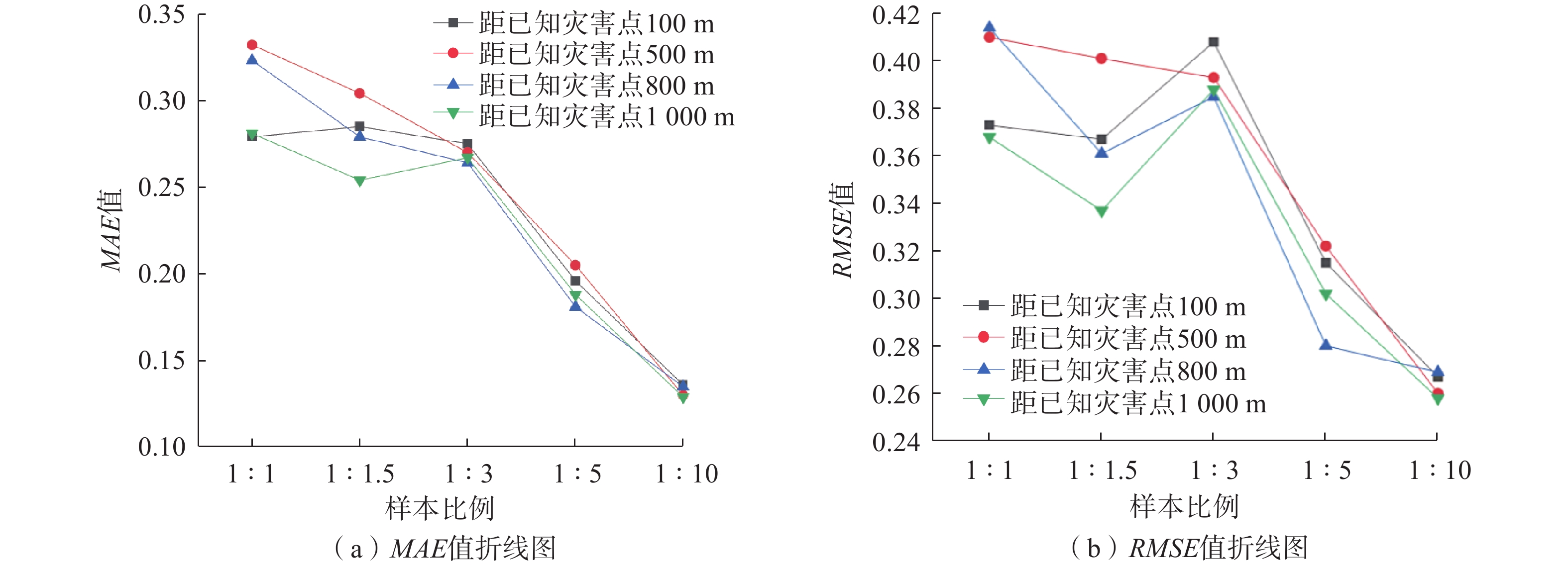
表 1 MAE和RMSE值
Table 1 MAE and RMSE values
距离 误差统计指标 1∶1 1∶1.5 1∶3 1∶5 1∶10 计算数据 距已知灾害点100 m MAE 0.279 0.285 0.275 0.196 0.136 RMSE 0.373 0.367 0.408 0.315 0.267 距已知灾害点500 m MAE 0.332 0.304 0.270 0.205 0.130 RMSE 0.410 0.401 0.393 0.322 0.260 距已知灾害点800 m MAE 0.323 0.279 0.264 0.181 0.135 RMSE 0.414 0.361 0.385 0.280 0.269 距已知灾害点1000 m MAE 0.281 0.254 0.267 0.188 0.129 RMSE 0.368 0.337 0.388 0.302 0.258  下载: 导出CSV
表 2 混淆矩阵
Table 2 Summary table of confusion matrix
地质灾害与非地质灾害样本比例1∶1 距已知灾害点100 m 真实值/个 距已知灾害点500 m 真实值/个 地质灾害 非地质灾害 地质灾害 非地质灾害 预测值 地质灾害 34 7 预测值 地质灾害 26 15 非地质灾害 11 39 非地质灾害 11 39 距已知灾害点800 m 真实值/个 距已知灾害点1000 m 真实值/个 地质灾害 非地质灾害 地质灾害 非地质灾害 预测值 地质灾害 31 10 预测值 地质灾害 35 6 非地质灾害 13 37 非地质灾害 10 40 ...... 地质灾害与非地质灾害样本比例1∶10 距已知灾害点800 m 真实值/个 距已知灾害点1000 m 真实值/个 地质灾害 非地质灾害 地质灾害 非地质灾害 预测值 地质灾害 435 13 预测值 地质灾害 442 6 非地质灾害 38 13 非地质灾害 41 10
下载: 导出CSV
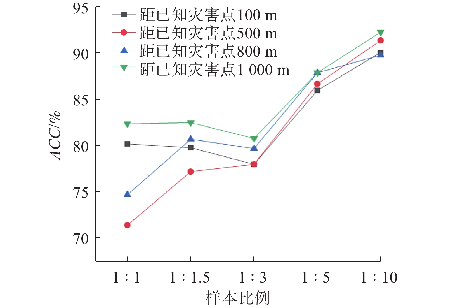
表 3 ACC值表
Table 3 Summary table of ACC values
距离 1∶1
占比/%1∶1.5
占比/%1∶3
占比/%1∶5
占比/%1∶10
占比/%距已知灾害点100 m 80.2 79.8 78.0 86.0 90.1 距已知灾害点500 m 71.4 77.2 78.0 86.0 91.4 距已知灾害点800 m 74.7 80.7 79.7 87.9 89.8 距已知灾害点1000 m 82.4 82.5 80.8 89.3 92.3
下载: 导出CSV
-
[1] ARABAMERI A,YAMANI M,PRADHAN B,et al. Novel ensembles of COPRAS multi-criteria decision-making with logistic regression,boosted regression tree,and random forest for spatial prediction of gully erosion susceptibility[J]. Science of the Total Environment,2019,688:903 − 916. DOI: 10.1016/j.scitotenv.2019.06.205
[2] UITTO J I,SHAW R. Sustainable development and disaster risk reduction:Introduction[M]//Sustainable Development and Disaster Risk Reduction. Tokyo:Springer,2016:1 − 12.
[3] JIANG Weiguo,RAO Pingzeng,CAO Ran,et al. Comparative evaluation of geological disaster susceptibility using multi-regression methods and spatial accuracy validation[J]. Journal of Geographical Sciences,2017,27(4):439 − 462. DOI: 10.1007/s11442-017-1386-4
[4] PAWLUSZEK-FILIPIAK K,OREŃCZAK N,PASTERNAK M. Investigating the effect of cross-modeling in landslide susceptibility mapping[J]. Applied Sciences,2020,10(18):6335. DOI: 10.3390/app10186335
[5] 申怀飞,董雨,杨梅,等. 基于AHP与信息量法的甘肃省滑坡易发性评估[J]. 水土保持研究,2021,28(6):412 − 419. [SHEN Huaifei,DONG Yu,YANG Mei,et al. Assessment on landslide susceptibility in Gansu Province based on AHP and information quantity method[J]. Research of Soil and Water Conservation,2021,28(6):412 − 419. (in Chinese with English abstract)] SHEN Huaifei, DONG Yu, YANG Mei, et al. Assessment on landslide susceptibility in Gansu Province based on AHP and information quantity method[J]. Research of Soil and Water Conservation, 2021, 28(6): 412 − 419. (in Chinese with English abstract)
[6] KANUNGO D P,ARORA M K,SARKAR S,et al. A comparative study of conventional,ANN black box,fuzzy and combined neural and fuzzy weighting procedures for landslide susceptibility zonation in Darjeeling Himalayas[J]. Engineering Geology,2006,85(3/4):347 − 366.
[7] 孙滨,祝传兵,康晓波,等. 基于信息量模型的云南东川泥石流易发性评价[J]. 中国地质灾害与防治学报,2022,33(5):119 − 127. [SUN Bin,ZHU Chuanbing,KANG Xiaobo,et al. Susceptibility assessment of debris flows based on information model in Dongchuan,Yunnan Province[J]. The Chinese Journal of Geological Hazard and Control,2022,33(5):119 − 127. (in Chinese with English abstract)] SUN Bin, ZHU Chuanbing, KANG Xiaobo, et al. Susceptibility assessment of debris flows based on information model in Dongchuan, Yunnan Province[J]. The Chinese Journal of Geological Hazard and Control, 2022, 33(5): 119 − 127. (in Chinese with English abstract)
[8] 熊小辉,汪长林,白永健,等. 基于不同耦合模型的县域滑坡易发性评价对比分析——以四川普格县为例[J]. 中国地质灾害与防治学报,2022,33(4):114 − 124. [XIONG Xiaohui,WANG Changlin,BAI Yongjian,et al. Comparison of landslide susceptibility assessment based on multiple hybrid models at County level:A case study for Puge County,Sichuan Province[J]. The Chinese Journal of Geological Hazard and Control,2022,33(4):114 − 124. (in Chinese with English abstract)] DOI: 10.16031/j.cnki.issn.1003-8035.202202052 XIONG Xiaohui, WANG Changlin, BAI Yongjian, et al. Comparison of landslide susceptibility assessment based on multiple hybrid models at County level: A case study for Puge County, Sichuan Province[J]. The Chinese Journal of Geological Hazard and Control, 2022, 33(4): 114 − 124. (in Chinese with English abstract) DOI: 10.16031/j.cnki.issn.1003-8035.202202052
[9] 吴常润,角媛梅,王金亮,等. 基于频率比-逻辑回归耦合模型的双柏县滑坡易发性评价[J]. 自然灾害学报,2021,30(4):213 − 224. [WU Changrun,JIAO Yuanmei,WANG Jinliang,et al. Frequency ratio and logistic regression models based coupling analysis for susceptibility of landslide in Shuangbai County[J]. Journal of Natural Disasters,2021,30(4):213 − 224. (in Chinese with English abstract)] DOI: 10.13577/j.jnd.2021.0423 WU Changrun, JIAO Yuanmei, WANG Jinliang, et al. Frequency ratio and logistic regression models based coupling analysis for susceptibility of landslide in Shuangbai County[J]. Journal of Natural Disasters, 2021, 30(4): 213 − 224. (in Chinese with English abstract) DOI: 10.13577/j.jnd.2021.0423
[10] 杜国梁,杨志华,袁颖,等. 基于逻辑回归-信息量的川藏交通廊道滑坡易发性评价[J]. 水文地质工程地质,2021,48(5):102 − 111. [DU Guoliang,YANG Zhihua,YUAN Ying,et al. Landslide susceptibility mapping in the Sichuan-Tibet traffic corridor using logistic regression-information value method[J]. Hydrogeology & Engineering Geology,2021,48(5):102 − 111. (in Chinese with English abstract)] DU Guoliang, YANG Zhihua, YUAN Ying, et al. Landslide susceptibility mapping in the Sichuan-Tibet traffic corridor using logistic regression-information value method[J]. Hydrogeology & Engineering Geology, 2021, 48(5): 102 − 111. (in Chinese with English abstract)
[11] 郭飞,王秀娟,陈玺,等. 基于不同模型的赣南地区小型削方滑坡易发性评价对比分析[J]. 中国地质灾害与防治学报,2022,33(6):125 − 133. [GUO Fei,WANG Xiujuan,CHEN Xi,et al. Comparative analyses on susceptibility of cutting slope landslides in southern Jiangxi using different models[J]. The Chinese Journal of Geological Hazard and Control,2022,33(6):125 − 133. (in Chinese with English abstract)] GUO Fei, WANG Xiujuan, CHEN Xi, et al. Comparative analyses on susceptibility of cutting slope landslides in southern Jiangxi using different models[J]. The Chinese Journal of Geological Hazard and Control, 2022, 33(6): 125 − 133. (in Chinese with English abstract)
[12] 黄发明,胡松雁,闫学涯,等. 基于机器学习的滑坡易发性预测建模及其主控因子识别[J]. 地质科技通报,2022,41(2):79 − 90. [HUANG Faming,HU Songyan,YAN Xueya,et al. Landslide susceptibility prediction and identification of its main environmental factors based on machine learning models[J]. Bulletin of Geological Science and Technology,2022,41(2):79 − 90. (in Chinese with English abstract)] HUANG Faming, HU Songyan, YAN Xueya, et al. Landslide susceptibility prediction and identification of its main environmental factors based on machine learning models[J]. Bulletin of Geological Science and Technology, 2022, 41(2): 79 − 90. (in Chinese with English abstract)
[13] 何书,鲜木斯艳·阿布迪克依木,胡萌,等. 基于自组织特征映射网络-随机森林模型的滑坡易发性评价——以江西大余县为例[J]. 中国地质灾害与防治学报,2022,33(1):132 − 140. [HE Shu,ABUDIKEYIMU XMSY,HU Meng,et al. Evaluation on landslide susceptibility based on self-organizing feature map network and random forest model:A case study of Dayu County of Jiangxi Province[J]. The Chinese Journal of Geological Hazard and Control,2022,33(1):132 − 140. (in Chinese with English abstract)] DOI: 10.16031/j.cnki.issn.1003-8035.2022.01-16 HE Shu, ABUDIKEYIMU XMSY, HU Meng, et al. Evaluation on landslide susceptibility based on self-organizing feature map network and random forest model: A case study of Dayu County of Jiangxi Province[J]. The Chinese Journal of Geological Hazard and Control, 2022, 33(1): 132 − 140. (in Chinese with English abstract) DOI: 10.16031/j.cnki.issn.1003-8035.2022.01-16
[14] GE G,SHI Zhongjie,ZHU Yuanjun,et al. Land use/cover classification in an arid desert-oasis mosaic landscape of China using remote sensed imagery:Performance assessment of four machine learning algorithms[J]. Global Ecology and Conservation,2020,22:e00971. DOI: 10.1016/j.gecco.2020.e00971
[15] 吉日伍呷,田宏岭,韩继冲. 基于不同机器学习算法的地震滑坡易发性评价——以鲁甸地震为例[J]. 昆明理工大学学报(自然科学版),2022,47(2):47 − 56. [JI R,TIAN Hongling,HAN Jichong. Evaluation of the susceptibility of earthquake landslides based on different machine learning algorithms:Taking Ludian earthquake as an example[J]. Journal of Kunming University of Science and Technology (Natural Science),2022,47(2):47 − 56. (in Chinese with English abstract)] JI R, TIAN Hongling, HAN Jichong. Evaluation of the susceptibility of earthquake landslides based on different machine learning algorithms: Taking Ludian earthquake as an example[J]. Journal of Kunming University of Science and Technology (Natural Science), 2022, 47(2): 47 − 56. (in Chinese with English abstract)
[16] 李坤,赵俊三,林伊琳,等. 基于RF和SVM模型的东川泥石流易发性评价研究[J]. 云南大学学报(自然科学版),2022,44(1):107 − 115. [LI Kun,ZHAO Junsan,LIN Yilin,et al. Assessment of debris flow susceptibility in Dongchuan based on RF and SVM models[J]. Journal of Yunnan University (Natural Sciences Edition),2022,44(1):107 − 115. (in Chinese with English abstract)] LI Kun, ZHAO Junsan, LIN Yilin, et al. Assessment of debris flow susceptibility in Dongchuan based on RF and SVM models[J]. Journal of Yunnan University (Natural Sciences Edition), 2022, 44(1): 107 − 115. (in Chinese with English abstract)
[17] 邱维蓉,吴帮玉,潘学树,等. 几种聚类优化的机器学习方法在灵台县滑坡易发性评价中的应用[J]. 西北地质,2020,53(1):222 − 233. [QIU Weirong,WU Bangyu,PAN Xueshu,et al. Application of several cluster-optimization-based machine learning methods in evaluation of landslide susceptibility in Lingtai County[J]. Northwestern Geology,2020,53(1):222 − 233. (in Chinese with English abstract)] DOI: 10.19751/j.cnki.61-1149/p.2020.01.021 QIU Weirong, WU Bangyu, PAN Xueshu, et al. Application of several cluster-optimization-based machine learning methods in evaluation of landslide susceptibility in Lingtai County[J]. Northwestern Geology, 2020, 53(1): 222 − 233. (in Chinese with English abstract) DOI: 10.19751/j.cnki.61-1149/p.2020.01.021
[18] DOU Jie,YUNUS A P,MERGHADI A,et al. Different sampling strategies for predicting landslide susceptibilities are deemed less consequential with deep learning[J]. Science of the Total Environment,2020,720:137320. DOI: 10.1016/j.scitotenv.2020.137320
[19] DOU Jie,YUNUS A P,TIEN BUI D,et al. Assessment of advanced random forest and decision tree algorithms for modeling rainfall-induced landslide susceptibility in the Izu-Oshima Volcanic Island,Japan[J]. Science of the Total Environment,2019,662:332 − 346. DOI: 10.1016/j.scitotenv.2019.01.221
[20] BEHNIA P,BLAIS-STEVENS A. Landslide susceptibility modelling using the quantitative random forest method along the northern portion of the Yukon Alaska Highway Corridor,Canada[J]. Natural Hazards,2018,90(3):1407 − 1426. DOI: 10.1007/s11069-017-3104-z
[21] WANG Yue,SUN Deliang,WEN Haijia,et al. Comparison of random forest model and frequency ratio model for landslide susceptibility mapping (LSM) in Yunyang County (Chongqing,China)[J]. International Journal of Environmental Research and Public Health,2020,17(12):4206. DOI: 10.3390/ijerph17124206
[22] YI Yaning,ZHANG Zhijie,ZHANG Wanchang,et al. Landslide susceptibility mapping using multiscale sampling strategy and convolutional neural network:A case study in Jiuzhaigou region[J]. CATENA,2020,195:104851. DOI: 10.1016/j.catena.2020.104851
[23] BREIMAN L. Random forests[J]. Machine Language,2001,45(1):5 − 32.
[24] 於佳宁,刘凯,张冰玥,等.中国区域TanDEM-X 90 m DEM高程精度评价及其适用性分析[J].地球信息科学学报,2021,23(04):646-657. [YU Jianing,LIU Kai,ZHANG Bingyue,et al. Vertical accuracy assessment and applicability analysis of TanDEM-X 90 m DEM in China[J]. Journal of Geo-information Science,2021,23(4):646 − 657.(in Chinese with English abstract)] YU Jianing, LIU Kai, ZHANG Bingyue, et al. Vertical accuracy assessment and applicability analysis of TanDEM-X 90 m DEM in China[J]. Journal of Geo-information Science, 2021, 23(4): 646 − 657.(in Chinese with English abstract)
[25] OSNA T,SEZER E A,AKGUN A. GeoFIS:An integrated tool for the assessment of landslide susceptibility[J]. Computers & Geosciences,2014,66:20 − 30.
[26] 张玘恺,凌斯祥,李晓宁,等. 九寨沟县滑坡灾害易发性快速评估模型对比研究[J]. 岩石力学与工程学报,2020,39(8):1595 − 1610. [ZHANG Qikai,LING Sixiang,LI Xiaoning,et al. Comparison of landslide susceptibility mapping rapid assessment models in Jiuzhaigou County,Sichuan Province,China[J]. Chinese Journal of Rock Mechanics and Engineering,2020,39(8):1595 − 1610. (in Chinese with English abstract)] DOI: 10.13722/j.cnki.jrme.2020.0029 ZHANG Qikai, LING Sixiang, LI Xiaoning, et al. Comparison of landslide susceptibility mapping rapid assessment models in Jiuzhaigou County, Sichuan Province, China[J]. Chinese Journal of Rock Mechanics and Engineering, 2020, 39(8): 1595 − 1610. (in Chinese with English abstract) DOI: 10.13722/j.cnki.jrme.2020.0029
[27] VAKHSHOORI V,POURGHASEMI H R,ZARE M,et al. Landslide susceptibility mapping using GIS-based data mining algorithms[J]. Water,2019,11(11):2292. DOI: 10.3390/w11112292
[28] 段宇英,汤军,刘远刚,等. 基于随机森林的山西省柳林县黄土滑坡空间敏感性评价[J]. 地理科学,2022,42(2):343 − 351. [DUAN Yuying,TANG Jun,LIU Yuangang,et al. Spatial sensitivity evaluation of loess landslide in Liulin County,Shanxi based on random forest[J]. Scientia Geographica Sinica,2022,42(2):343 − 351. (in Chinese with English abstract)] DOI: 10.13249/j.cnki.sgs.2022.02.016 DUAN Yuying, TANG Jun, LIU Yuangang, et al. Spatial sensitivity evaluation of loess landslide in Liulin County, Shanxi based on random forest[J]. Scientia Geographica Sinica, 2022, 42(2): 343 − 351. (in Chinese with English abstract) DOI: 10.13249/j.cnki.sgs.2022.02.016
[29] 吴润泽,胡旭东,梅红波,等. 基于随机森林的滑坡空间易发性评价——以三峡库区湖北段为例[J]. 地球科学,2021,46(1):321 − 330. [WU Runze,HU Xudong,MEI Hongbo,et al. Spatial susceptibility assessment of landslides based on random forest:A case study from Hubei section in the Three Gorges Reservoir area[J]. Earth Science,2021,46(1):321 − 330. (in Chinese with English abstract)] WU Runze, HU Xudong, MEI Hongbo, et al. Spatial susceptibility assessment of landslides based on random forest: A case study from Hubei section in the Three Gorges Reservoir area[J]. Earth Science, 2021, 46(1): 321 − 330. (in Chinese with English abstract)
[30] TSANGARATOS P,ILIA I. Comparison of a logistic regression and Naïve Bayes classifier in landslide susceptibility assessments:The influence of models complexity and training dataset size[J]. CATENA,2016,145:164 − 179. DOI: 10.1016/j.catena.2016.06.004
[31] SHIRZADI A,SOLAIMANI K,ROSHAN M H,et al. Uncertainties of prediction accuracy in shallow landslide modeling:Sample size and raster resolution[J]. CATENA,2019,178:172 − 188. DOI: 10.1016/j.catena.2019.03.017
-
期刊类型引用(6)
1. 何胜庆,郑达,张文. 高海拔地区宽级配泥石流冲击拦砂坝试验研究. 水文地质工程地质. 2024(01): 123-134 .  百度学术
百度学术
2. 沈凌铠,周保,魏刚,魏赛拉加,常文斌,张明哲,邢爱国. 气温变化对多年冻土斜坡稳定性的影响——以青海省浅层冻土滑坡为例. 中国地质灾害与防治学报. 2023(01): 8-16 . 本站查看
3. 苏晓军,孟兴民,张毅,岳东霞,周自强,郭富赟. 中巴经济走廊地质灾害研究进展与展望. 兰州大学学报(自然科学版). 2023(05): 694-710 . 百度学术
4. 彭帅英,李霄琳,牛岑岑,乔双双. 泥石流模拟实验装置及虚拟仿真平台设计与应用. 实验技术与管理. 2023(10): 153-158 . 百度学术
5. 文强,胡卸文,刘波,席传杰,何坤. 四川丹巴梅龙沟“6·17”泥石流成灾机理分析. 中国地质灾害与防治学报. 2022(03): 23-30 . 本站查看
6. 胡艳香,朱厚影,陈昊,薛凯喜,韩静云,梁海安. 贺兰山苏峪口泥石流物源启动模型试验分析. 中国地质灾害与防治学报. 2022(06): 44-52 . 本站查看
其他类型引用(3)


计量
- 文章访问数: 867
- HTML全文浏览量: 795
- PDF下载量: 128
- 被引次数: 9
 邮件订阅
邮件订阅 RSS
RSS