
Progress of the special-subjects study on the construction of comprehensive geological disaster prevention and control system in Yunnan Province
-
摘要: 云南省地质灾害综合防治体系建设是国内规模最大、最广泛的地质灾害防治专项,其实施使全省地质灾害发生数量大幅减少,因灾死亡及失踪人数明显递减,防灾减灾成效显著。文章依据12项系列专题研究成果,综述了体系建设实施概况及防灾减灾成效,归纳评述了取得的主要科技成果,重点对高原地质灾害成因、规律认识、特殊岩土控灾机制、易发性分区评价、隐患综合遥感识别、自动化监测预警及信息标准体系建设进展进行了总结,成果可为云南省地质灾害综合防治提供经验借鉴。Abstract: The establishment of the comprehensive geological disaster prevention and control system in Yunnan province stands as China’s most extensive and grand-scale endeavor in safeguarding the prevention and control of geological disasters in China. Its implementation has led to a significant reduction in the occurrence of geological disasters, resulting in a substantial decrease in both casualties and missing persons affected by such disasters. This accomplishment has yielded remarkable outcomes in disaster prevention and mitigation. Based on the results of 12 series monographic studies, this paper provides an overview of the implementation of the system and its disaster prevention and mitigation effects. It summarizes the main scientific and technological achievements, with a particular focus on the causes and patterns of plateau geological disasters, understanding of special rock and soil disaster control mechanisms, susceptibility zoning evaluation, comprehensive remote sensing identification of geological hazards, progress in automated monitoring and early warning, and the development of geological environment information standard system. These achievements can provide valuable insights for the comprehensive geological disaster prevention and control in Yunnan Province.
-
0. 引 言
不稳定边坡是公路沿线常见的一种不良地质灾害现象[1],在降雨情况下,往往会失稳滑动,威胁公路运营安全。公路沿线滑坡体正确处治以地质勘察的准确性作为前提,地质钻探结合调绘工作是滑坡勘察的主流手段。但由于地质钻探工期较长且在不稳定边坡上施工有一定安全隐患,而物探手段具有高效、快捷、可直观成像等特点,因此物探方法发挥的作用越来越大[2-6]。
在公路边坡灾害探测中,常用的物探手段包括:电法[7]、探地雷达、瞬变电磁法、浅层地震等方法,且都取得了不错的效果。单一方法应用研究较多,将电阻率与速度参数有机结合的应用较少。文章依据公路不稳定边坡探测实例,通过常规对称四极电阻率测深与瞬态面波[8-10]相结合,对滑坡体进行勘察,准确高效的圈定滑坡范围,识别滑面及潜在滑面位置,为后续处治工作提供了合理可靠的支撑。
1. 研究区地质概况
1.1 研究区概述
G5京昆高速(雅安至西昌段)90 km附近右侧存在不稳定斜坡,坡高约50 m,为5级坡。通车前已进行过处治,坡角为重力式挡墙,坡体采用框架梁形式进行防护。但在强降雨及周边施工开挖扰动情况下,受重力及水压力作用,出现滑移变形,框架梁发生严重变形错位。边坡表面多处可见土体裂缝,部分框架梁被剪断(图1),对该段高速公路运营威胁极大。
1.2 边坡结构特征
坡角采用重力式挡墙,I、II级坡面为自然削坡后植被防护,由于坡度小,自然坡角稳定,坡体及表面未出现变形现象,上部III—V级坡面采用框架护坡(图2),经地面调查和钻探揭示,防护主体为第四系崩坡残积Q4col+dl碎石土和Q3col+dl碎石土。边坡变形部分主要为Q4col+dl松散含角砾黏土层及部分碎石土层。
1.3 边坡变形特征
依照地质调绘分析,变形段边坡高约50 m,分5级,边坡坡比为1∶1.25,每级边坡高约10 m,平台宽约2 m,边坡上部3~5级边坡为框架锚杆处治,主体为黏土层及崩坡积层块石土,路嵌挡墙为重力式挡墙,墙体无明显变形,下部2级采用削坡及植被护坡。边坡主要为含砾黏土、块石土。I、II级坡面无明显变形,局部有浅表性滑塌,长约5~8 m,影响深度约1 m,钻孔ZK4处于II级平台,出现拉裂缝,其附近坡表变形严重,致使3级坡表框架梁严重变形拉裂,土体呈隆起剪出状。III级平台及IV级平台挡墙前均出现长约30 m贯通性拉裂缝,其中IV级平台挡墙墙体出现变形,下部局部出现淘空现象。V级坡面菱形框架梁出现整体下沉,边缘出现剪断现象。边坡后缘已形成高约1~2 m的陡坎,并形成宽约0.2 m裂缝,深约1 m,有逐渐垮塌后退趋势。滑坡后沿排截水沟出现夸塌拉裂现象。
2. 边坡变形分析及物探方法选择
2.1 边坡变形机理
由于斜坡前期开挖时坡度较陡,坡表植被难以形成较好防护效果,加上长时间降雨渗透使覆盖层抗剪能力减弱,引起坡体失稳。同时,由于Q3c+dl地层较为密实,新近系与第四系地层之间易产生相对富水区,在斜坡重力作用下,逐渐产生滑移现象,并会持续加剧,对防护结构造成破坏,坡体拉裂变形,最终造成整个边坡结构失稳垮塌,严重威胁下方高速公路。因此,需要快速对斜坡开展准确的勘察设计工作。
2.2 边坡地球物理特征分析
通过边坡变形机理分析,主要为富水带引起滑动,从物性特征来看,会产生明显的电阻率及波速变化,且由于斜坡滑动时还会产生裂隙发育区域,附近土体或岩体会造成不同程度的破坏,从而产生明显的物性差异。
通常来说,滑体内波速比稳定区域会明显降低,横波和纵波比(Vp/Vs)也相应增大,且这种变化与岩(土)体破坏程度呈正比。相应的,滑体电阻率也呈类似特征,在含水情况下则会更加明显。
因此,组成滑坡的地质体物性参数与稳定区域存在较=为明显的差异,是利用物探技术研究滑坡的物理基础。
2.3 综合物探方法选择及基本原理
根据2.2节对地球物理特征的分析,本次研究选用电法勘探与瞬态面波相结合的综合物探手段。
2.3.1 电测深勘探基本原理
电测深法[7,11-13]是利用探测地质体的导电性质的不同,根据电阻率的变化特征判断地质体分布情况,完成勘察目标。
根据现场条件及技术要求,本次工作采用对称四极装置进行数据采集,其电极排列方式如图3所示。该装置主要特征为两边极距的对称性,即:
![]() 图 3 对称四极排列装置形式示意图Figure 3. Schematic diagram of symmetrical quadrupole arrangement device
图 3 对称四极排列装置形式示意图Figure 3. Schematic diagram of symmetrical quadrupole arrangement device2.3.2 瞬态面波勘探基本原理
相对常用的折射、反射等浅层地震勘探,瞬态面波法[14-17]在20世纪70年代国际上才开始研究,基本原理是通过瑞雷面波频散曲线,采用定量分析,取得不同地下介质弹性波的传播速度,根据速度的差异,可以反映出地层物性差异情况。基于以上原理,能够划分岩土界面、软弱带等,达到解决相应地质问题的目的。瞬态面波勘察法对薄层分辨率高,能通过成像直观表示地下地质体及地质构造,能够在滑坡探测上取得较好的成像效果。
工程勘察时,通常采用瑞雷面波,因此瞬态面波勘探又常称为瑞雷波法,主要具有以下特点:
(1)当传播介质均匀时,瑞雷波波长
层状介质时,
(2)通过计算可知:当深度
根据公式
(3)瑞雷波速度
(1) 根据式(1)得到地质体与
泊松比 0.25 0.38 0.40 0.50 Vr /Vs 0.920 0.939 0.943 0.955 3. 综合物探方法关键技术研究
3.1 电测深关键技术分析
3.1.1 测量装置及极距选择
(1)装置选择:在电法勘探中,根据现场条件进行装置选择是开展工作的一个重要环节,通常来说,装置设计主要由研究区地形条件、目标体规模、测量精度等方面决定,而四极装置可以达到最大的测量电位,能够节省外接电源,减少供电电压,最重要的是可以压制干扰,提高信噪比,在场地条件允许下,为最优选择方案。因此本次研究工作采用对称四极装置,最大供电电压为400 V。
(2)极距选择:电法勘探过程中,极距的选择与勘探深度密切相关,在本次研究中,电法勘探深度要求超过35 m。为了使
3.1.2 研究区电阻率分析测试及解释原则
精确解释的前提是对场区物性参数的准确统计测试,因此,解释前首先要将研究区电阻率参数进行统计,本次依据现场试验及工区综合统计得出以下电阻率参数见表2。
在深度转换时,利用已有钻孔资料进行约束校正,根据钻孔资料揭示的地质分层信息,试验并确定了本次电测深资料解释深度转换采用极距(AB/2)与深度的比值系数为0.95~0.5之间,转换后物探成果解释深度与钻探揭示的地层深度基本吻合。
表 2 研究区电阻率实测参数表Table 2. Measured parameters of resistivity in study area岩性 电阻率值ρ/(Ω·m) 表现特征 黏土层 <200 等值线平滑 稳定堆积体(冰水堆积层) 200~500 等值线紊乱 基岩 >500 等值线平滑 滑面 <200 低阻闭合圈 3.2 瞬态面波关键技术研究
3.2.1 原始数据采集关键问题
在时域内,原始数据采集质量与频散曲线有直接关系。同地震反射类似,瞬态面波法同样有最佳窗口。为提高原始数据精度,增加处理解释精度,面波数据采集时应注意以下关键采集问题:
(1)采样时每道设计排列不能超过面波域,同时采集到足够长记录;
(2)采集时要避开附近振动干扰,减少直达波的后续波或反射、折射波干扰面波;
(3)采集的波形真实可靠。
依照上述原则,排列设计时,应根据勘探深度的要求设计合适的偏移距以及道间距,若偏移距较小,高频分量较大,能凸显浅部信号;要想得到深部信息,则应加大偏移距,使高频分量衰减,凸显低频分量。
在震源选择上,瞬态瑞雷波法的激震可采用大锤或吊锤自由落下,常规来说,勘探深度20~30 m范围内时,24磅大锤激发就能得到较为理想的频散曲线,在介质较软,或勘探深度要求较深时,需要较重吊锤自由落下,能够得到理想的低频震动。
本次研究使用的设备为北京水电物探研究所研制的SWS-6型面波仪,单点激发,12道接收进行数据采集。偏移距10~30 m,道间距l m,采样间隔0.5 ms,记录长度1024 ms。面波的激发采用锤击法,重15 kg。实际工作中,为获取更可靠的面波数据,每个测点上应重复锤击3~5次,采用面波干扰小、能量强、信噪比高的激发记录作为该测点的面波采集数据。
3.2.2 研究区波速分析测试及解释原则
与电法勘探一样,研究区波速参数的准确统计也是面波解释的重要前提条件,由于面波波速近似等于横波波速,因此本次依据现场孔内剪切波测试得出以下参数,见表3。
表 3 研究区横波波速实测参数表Table 3. Measured parameters of shear wave velocity in study area岩性 横波波速v/(m·s−1) 表现特征 粘土层 <200 低速层 稳定堆积体(冰水堆积层) 200~1000 波速变化大 滑面 <200 低速带 数据处理使用SWS-6型面波仪专用处理软件进行,利用频散曲线变化特征分析测点位置面波速度随深度的变化情况,判断地下地质条件。频散曲线与地下介质的层厚度、波速等参数有紧密联系,分析这些变化规律和特征,可以初步确定速度层的层数以及各层的厚度和速度范围,再结合已有地质资料对曲线进行综合分析与定量解释,得到各层的厚度以及波速,达到对地质体分层和识别滑坡的目的。
4. 成果分析
4.1 测线布设
依照现场地形,结合前期调绘圈定的滑坡体的范围,垂直布置纵横两条剖面(沿高速公路方向为纵剖面,垂直高速路线方向为横剖面),电测深法与面波法测线重合,以便互相验证。具体测线位置见图4。
4.2 物探成果解释
根据上述处理解释方法得到物探解释成果图件(图5、6、7、8),结合地质调绘资料进行综合地质解释。
根据解释资料分析:面波横剖面(图5)中30~80 m范围,表层3~5m深度存在明显低速带,波速
在电测深成果图中(图7、图8),分层也较为清晰,能够得出明确的三层界面:黏土层、稳定堆积体层以及基岩,但纵向分辨率较面波成果低,较难识别出滑面具体位置,解释时要参考面波成果图进行滑面判别。
依照两种方法成果综合分析,滑坡体厚度约为3~4 m,剖面75 m附近较厚,约6~7 m,推测在横剖面30 m处剪出,横剖面90 m处为滑坡后缘,覆盖层整体厚度超过30 m,滑坡体及覆盖层形态见图5~8。
4.3 地质验证
(1)结合现场坡体变形情况,坡体剪出位置与物探推测位置吻合,边坡在测线58 m、72 m、97 m、103 m和116 m处出现土体裂缝及部分框架梁破坏位置,均在物探推测滑坡体范围内,变形范围与物探成果推测一致;根据现场调绘的滑体厚度也与推测结果一致。
(2)依照综合物探解释成果,结合地质调绘,在推测主滑面位置布设5个钻孔,绘制出边坡综合地质成果图(图9),钻探揭示滑面深度、滑坡体规模等与物探结果基本吻合,表明综合物探能在不稳定边坡勘察中取得良好效果。
5. 结论
(1)综合瞬态面波与电测深成果,较为准确的推测出滑坡体的规模、形态以及滑面位置,与地质资料对比,两者具有很好的一致性。
(2)电法勘探与面波勘探相结合,可互相验证,利于消除物探多解性,在滑坡探测中具有快速、有效、直观的特点,可在类似条件下滑坡识别进行推广应用。
(3)由于地质体不同物性参数的差异,造成不同物探方法对地质体表现结果并不完全一致,解释时必须有效结合地质调绘及钻孔信息,去伪存真,才能发挥物探工作的作用,没有地质基础的物探解释可能会造成误判。
-
![]()
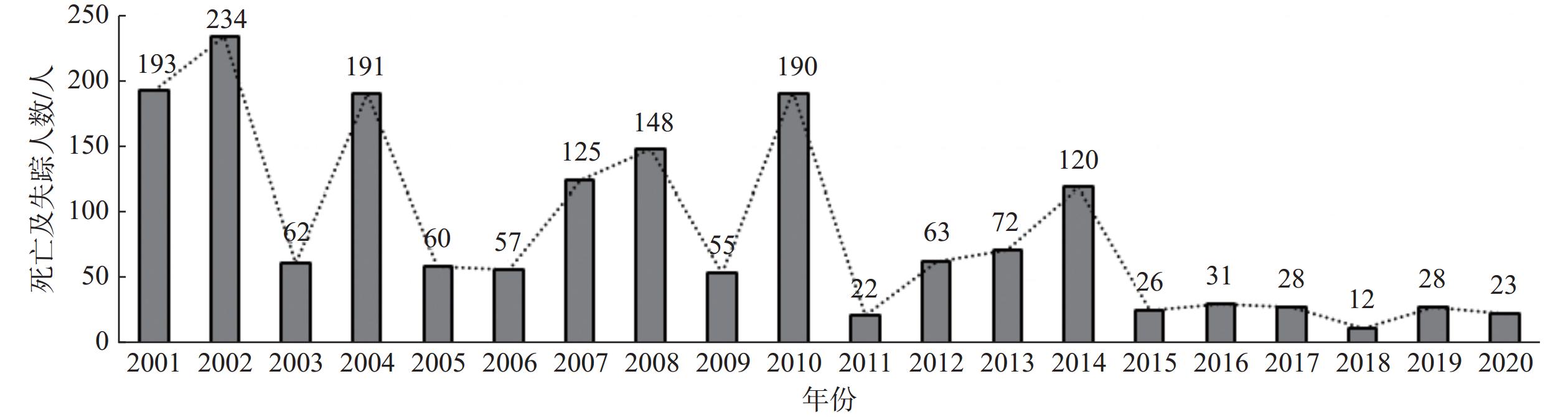
图 1 2001—2020年云南省地质灾害发生数量统计图
Figure 1. Statistical chart of the number of geological disasters occurred in Yunnan Province from 2001 to 2020
![]()
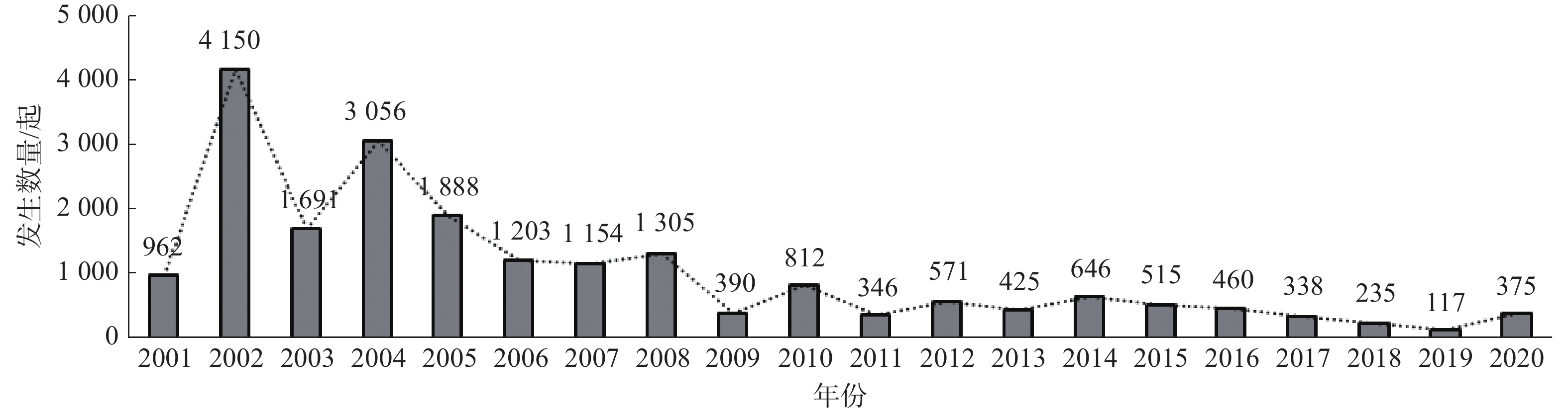
图 2 2001—2020年云南省地质灾害死亡及失踪人数统计图
Figure 2. Statistical chart of the number of deaths and missing persons from geological disasters in Yunnan Province from 2001 to 2020
![]()
图 3 德钦县城重大地质灾害分布图
Figure 3. Distribution map of major geological disasters in the Deqin County Town
![]()
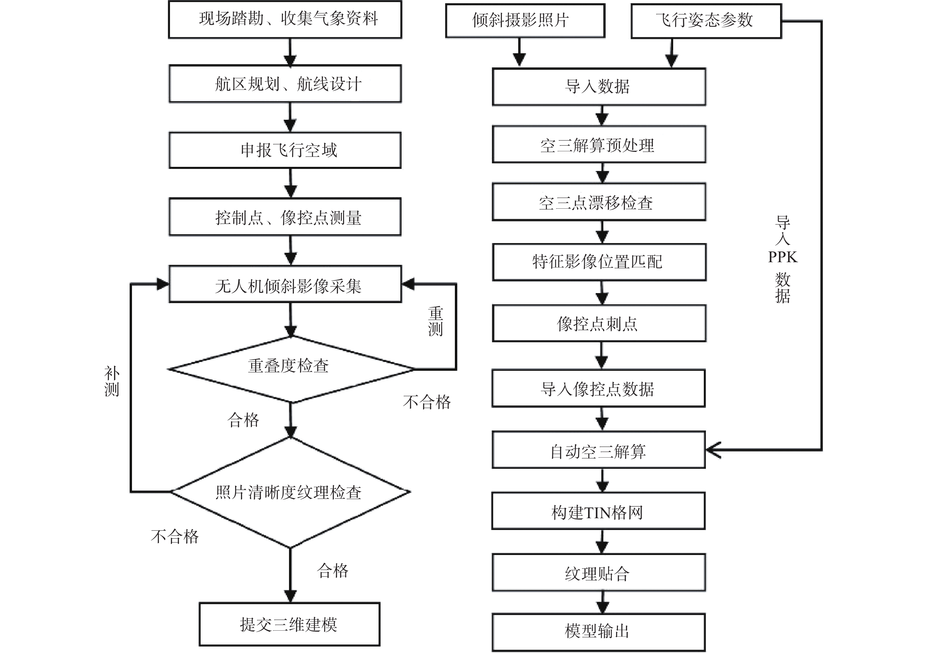
图 4 倾斜摄影及三维实景建模技术流程图
Figure 4. Technical flow chart of aerial photography and 3D realistic modeling technology
![]()
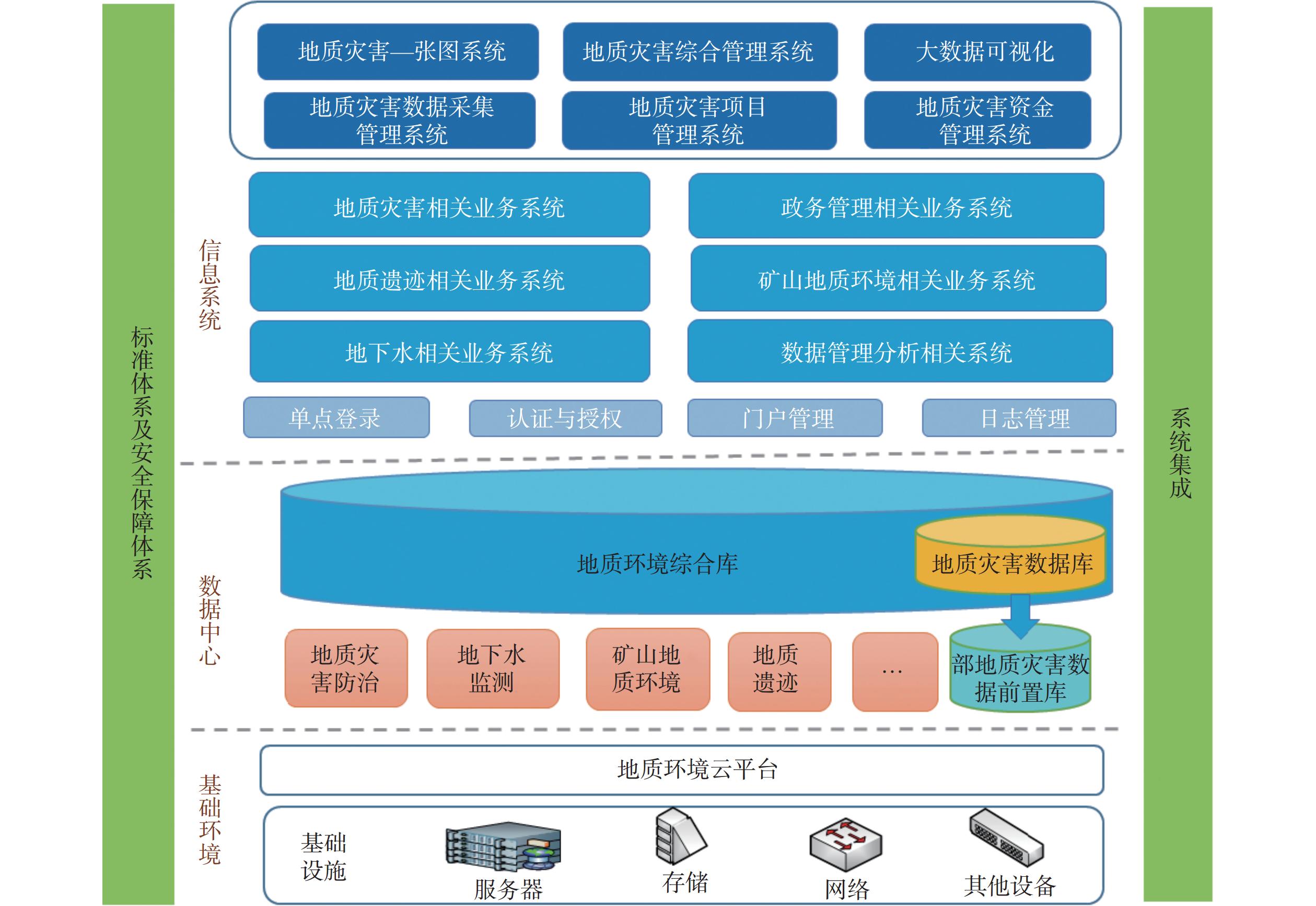
图 5 云南省地质环境信息平台框架图
Figure 5. Framework of the geological environment information platform in Yunnan Province
![]()
图 6 绿春县城削峰填谷前后对比图
Figure 6. Before and after comparison of peak cutting and valley filling in Lvchun County Town
表 1 研究专题设置情况
Table 1 The research topic setting fact sheet
编号 专题名称 牵头单位/协作单位 1 云南高原地质环境特征与地质灾害发育规律研究 云南省地质环境监测院/昆明理工大学 2 云南高原山区地质灾害应急技术支撑体系研究 云南省地质环境监测院 3 云南高原山区崩滑流地质灾害自动化监测预警技术方法研究 云南省地质环境监测院 4 云南高原山区地质灾害隐患综合遥感识别技术研究 云南省地质环境监测院/中国自然资源航空物探遥感中心、中南大学 5 面向降雨型滑坡时空信息服务关键技术应用研究 云南省自然资源厅国土资源信息中心/云南省地质环境监测院、
中国地质大学(武汉)6 高原山区复杂环境条件地质灾害综合防治新型工程技术体系研究 云南地质工程勘察设计研究院 7 高原环境特殊岩土体地质灾害成因机制及防治工程技术研究 云南地质工程第二勘察院 8 高原岩溶场地塌陷隐患勘测识别及防治技术研究 中国有色金属工业昆明勘察设计研究院 9 云南高原深切峡谷区水利水电工程地质灾害问题及防治措施研究 云南华昆国电工程勘察有限公司/中国电建集团昆明勘测设计研究院、
昆明理工大学10 云南高原公路工程重大地质灾害成因机制及防治技术研究 云南省交通规划设计研究院 11 云南高原采矿沉陷区次生地质灾害隐患识别及防治对策研究 昆明煤炭设计研究院/昆明理工大学 12 云南高原地质灾害发育规律及防治技术序列研究 云南省地质调查局/云南省地质环境监测院、云南地质工程勘察设计研究院 13 《云南省地质灾害防治与地质环境保护研究论文集》选辑 云南省地质灾害研究会  下载: 导出CSV
表 2 云南省地质环境条件分区表
Table 2 Zoning of geological environmental conditions in Yunnan Province
地质环境条件等级 分区代号 分区名称 面积/km2 占全省面积/% 差 Ⅰ1 金沙江上游碎屑岩高山峡谷区 20 263.08 5.14 Ⅰ2 怒江流域中上游花岗岩变质岩高山峡谷区 18 525.07 4.70 Ⅰ3 金沙江北段碎屑岩玄武岩中山峡谷区 21 715.10 5.51 Ⅰ4 金沙江中段碎屑岩红层区 12 019.53 3.05 Ⅰ5 金沙江下游玄武岩碎屑岩深切割中山峡谷区 15 523.85 3.94 Ⅰ6 哀牢山变质岩中山峡谷区 28 561.80 7.25 较差 Ⅱ1 兰坪漾濞碎屑岩变质岩高山峡谷区 13 288.97 3.37 Ⅱ2 怒江流域中下游碎屑岩花岗岩宽谷区 31 892.84 8.09 Ⅱ3 景东镇沅变质岩深切山区 16 379.76 4.16 Ⅱ4 澜沧江中下游花岗岩中山宽谷区 22 130.89 5.61 中等 Ⅲ1 滇西花岗岩宽谷盆地区 16 133.86 4.09 Ⅲ2 丽江大理碎屑岩高原湖盆区 13 610.39 3.45 Ⅲ3 滇中碎屑岩红层高原区 25 383.59 6.44 Ⅲ4 威信镇雄碎屑岩碳酸盐岩褶皱山区 6 260.75 1.59 Ⅲ5 滇东碳酸盐岩碎屑岩山区 6 376.07 1.62 Ⅲ6 红河小江流域碳酸盐岩山区 5 474.41 1.39 Ⅲ7 富宁麻栗坡碎屑岩裂陷山区 7 404.82 1.88 Ⅲ8 澜沧江下游花岗岩变质岩宽谷区 21 476.98 5.45 较好 Ⅳ1 香格里拉松散层高原剥夷面 2 237.94 0.57 Ⅳ2 昭通鲁甸碎屑岩高原盆地区 2 544.78 0.65 Ⅳ3 滇东碳酸盐岩高原湖盆区 45 164.68 11.46 Ⅳ4 滇东南碳酸盐岩岩溶丘峰区 24 247.46 6.15 Ⅳ5 滇南碎屑岩低中山区 17 522.38 4.45 好 区域分布面积小且比较分散,不单独划区
下载: 导出CSV
表 3 怒江流域北段高山峡谷区地质灾害激发雨强预警判据
Table 3 Criteria for early warning of geological disasters in the alpine valley area of the northern section of the Nujiang River Basin
预警等级 预警时效/h 预警判据/mm 崩塌 滑坡 泥石流 一级 1 6 9 20 二级 6 8 三级 4.5 5 一级 24 80 110 120 二级 60 70 90 三级 35 45 60
下载: 导出CSV
-
[1] 王宇,杨迎冬,晏祥省,等. 云南鲁甸6·5级地震次生特大地质灾害的特征及原因[J]. 灾害学,2016,31(1):83 − 86. [WANG Yu,YANG Yingdong,YAN Xiangsheng,et al. Characteristics and causes of super-huge secondary geological hazards induced by M6.5 Ludian earthquake in Yunnan[J]. Journal of Catastrophology,2016,31(1):83 − 86. (in Chinese with English abstract) WANG Yu, YANG Yingdong, YAN Xiangsheng, et al . Characteristics and causes of super-huge secondary geological hazards induced by M6.5 Ludian earthquake in Yunnan[J]. Journal of Catastrophology,2016 ,31 (1 ):83 −86 . (in Chinese with English abstract)[2] 韩俊,王保云. 基于原型网络的云南怒江州泥石流灾害易发性评价与区划[J]. 中国地质灾害与防治学报,2023,34(5):117 − 129. [HAN Jun,WANG Baoyun. A case study on the susceptibility assessment of debris flows disasters based on prototype network in Nujiang Prefecture, Yunnan Province[J]. The Chinese Journal of Geological Hazard and Control,2020,34(5):117 − 129. (in Chinese with English abstract) HAN Jun, WANG Baoyun . A case study on the susceptibility assessment of debris flows disasters based on prototype network in Nujiang Prefecture, Yunnan Province[J]. The Chinese Journal of Geological Hazard and Control,2020 ,34 (5 ):117 −129 . (in Chinese with English abstract)[3] 杨得虎,朱杰勇,刘帅,等. 基于信息量、加权信息量与逻辑回归耦合模型的云南罗平县崩滑灾害易发性评价对比分析[J]. 中国地质灾害与防治学报,2023,34(5):43 − 53. [YANG Dehu,ZHU Jieyong,LIU Shuai,et al. Comparative analyses of susceptibility assessment for landslide disasters based on information value, weighted information value and logistic regression coupled model in Luoping County, Yunnan Province[J]. The Chinese Journal of Geological Hazard and Control,2023,34(5):43 − 53. (in Chinese with English abstract) YANG Dehu, ZHU Jieyong, LIU Shuai, et al . Comparative analyses of susceptibility assessment for landslide disasters based on information value, weighted information value and logistic regression coupled model in Luoping County, Yunnan Province[J]. The Chinese Journal of Geological Hazard and Control,2023 ,34 (5 ):43 −53 . (in Chinese with English abstract)[4] 杨迎冬,汤沛,肖华宗,等. 云南省地质灾害与水系关系初步分析[J]. 灾害学,2017,32(3):36 − 39. [YANG Yingdong,TANG Pei,XIAO Huazong,et al. Preliminary analysis on relationships between geo-hazards and river systems of Yunnan Province[J]. Journal of Catastrophology,2017,32(3):36 − 39. (in Chinese with English abstract) YANG Yingdong, TANG Pei, XIAO Huazong, et al . Preliminary analysis on relationships between geo-hazards and river systems of Yunnan Province[J]. Journal of Catastrophology,2017 ,32 (3 ):36 −39 . (in Chinese with English abstract)[5] 王宇. 云南省地质灾害防治与研究历史评述[J]. 灾害学,2019,34(3):134 − 139. [WANG Yu. Historical review of geological disaster prevention and research in Yunnan Province,China[J]. Journal of Catastrophology,2019,34(3):134 − 139. (in Chinese with English abstract) DOI: 10.3969/j.issn.1000-811X.2019.03.025 WANG Yu . Historical review of geological disaster prevention and research in Yunnan Province, China[J]. Journal of Catastrophology,2019 ,34 (3 ):134 −139 . (in Chinese with English abstract) DOI: 10.3969/j.issn.1000-811X.2019.03.025[6] 王宇,祝传兵,张杰,等. 云南省地质灾害应急监测预警及处置措施研究[R]. 昆明:云南省地质调查局,2020. [WANG Yu,ZHU Chuanbing,ZHANG Jie,et al. Research on emergency monitoring and warning and disposal measures of geological disasters in Yunnan Province [R]. Kunming:Yunnan Geological Survey,2020. (in Chinese) WANG Yu, ZHU Chuanbing, ZHANG Jie, et al. Research on emergency monitoring and warning and disposal measures of geological disasters in Yunnan Province [R]. Kunming: Yunnan Geological Survey, 2020. (in Chinese)
[7] 王宇,黄成,周翠琼,等. 山区地质灾害应急调查的内涵及方法分析评述[J]. 中国岩溶,2020,39(4):492 − 499. [WANG Yu,HUANG Cheng,ZHOU Cuiqiong,et al. Review on the connotation and methods of emergency investigations to geological hazards in mountainous area[J]. Carsologica Sinica,2020,39(4):492 − 499. (in Chinese with English abstract) WANG Yu, HUANG Cheng, ZHOU Cuiqiong, et al . Review on the connotation and methods of emergency investigations to geological hazards in mountainous area[J]. Carsologica Sinica,2020 ,39 (4 ):492 −499 . (in Chinese with English abstract)[8] 宋昭富,张勇,佘涛,等. 基于易发性分区的区域滑坡降雨预警阈值确定——以云南龙陵县为例[J]. 中国地质灾害与防治学报,2023,34(4):22 − 29. [SONG Zhaofu,ZHANG Yong,SHE Tao,et al. Determination of regional landslide rainfall warning threshold based on susceptibility zoning: A case study in Longling County of Yunnan Province[J]. The Chinese Journal of Geological Hazard and Control,2023,34(4):22 − 29. (in Chinese with English abstract) SONG Zhaofu, ZHANG Yong, SHE Tao, et al . Determination of regional landslide rainfall warning threshold based on susceptibility zoning: A case study in Longling County of Yunnan Province[J]. The Chinese Journal of Geological Hazard and Control,2023 ,34 (4 ):22 −29 . (in Chinese with English abstract)[9] 王宇,康晓波,柴金龙,等. 云南高原地质灾害发育规律及防治技术序列研究报告[R]. 昆明:云南省地质调查局. 2022. [WANG Yu,KANG Xiaobo,CHAI Jinlong,et al. Research report on the development law and control technology sequence of geological hazards in Yunnan Plateau[R]. Kunming:Yunnan Geological Survey,2022. (in Chinese) WANG Yu, KANG Xiaobo, CHAI Jinlong, et al. Research report on the development law and control technology sequence of geological hazards in Yunnan Plateau[R]. Kunming: Yunnan Geological Survey, 2022. (in Chinese)
[10] 张奇林,赫念学,黄兴章,等. 高原山区复杂环境条件地质灾害综合防治新型工程技术体系研究专题研究报告[R]. 昆明:云南地质工程勘察设计研究院有限公司. 2021. [ZHANG Qilin,HE Nianxue,HUANG Xingzhang,et al. Research report on new engineering technology system of comprehensive prevention and control of geological disasters under complex environmental conditions in Plateau mountainous areas [R]. Kunming:Yunnan Geological Engineering Survey and Design Research Institute Limited Company,2021. (in Chinese) ZHANG Qilin, HE Nianxue, HUANG Xingzhang, et al. Research report on new engineering technology system of comprehensive prevention and control of geological disasters under complex environmental conditions in Plateau mountainous areas [R]. Kunming: Yunnan Geological Engineering Survey and Design Research Institute Limited Company, 2021. (in Chinese)
[11] 杨迎冬,晏祥省,王宇,等. 云南省地质灾害特征及形成规律研究[J]. 灾害学,2021,36(3):131 − 139. [YANG Yingdong,YAN Xiangsheng,WANG Yu,et al. The characteristics and formation of geological hazards in Yunnan Province[J]. Journal of Catastrophology,2021,36(3):131 − 139. (in Chinese with English abstract) DOI: 10.3969/j.issn.1000-811X.2021.03.023 YANG Yingdong, YAN Xiangsheng, WANG Yu, et al . The characteristics and formation of geological hazards in Yunnan Province[J]. Journal of Catastrophology,2021 ,36 (3 ):131 −139 . (in Chinese with English abstract) DOI: 10.3969/j.issn.1000-811X.2021.03.023[12] 李强,刘珍,尹博,等. 高原环境特殊岩土体地质灾害成因机制及防治工程技术专题研究报告[R]. 昆明:云南地质工程第二勘察院有限公司. 2021. [LI Qiang,LIU Zhen,YIN Bo,et al. Research report on the cause mechanism and control engineering technology of geological disasters of special rock and soil mass in plateau environment [R]. Kunming:Yunnan Geological Engineering the Second Investigation Institute Limited Company,2021. (in Chinese) LI Qiang, LIU Zhen, YIN Bo, et al. Research report on the cause mechanism and control engineering technology of geological disasters of special rock and soil mass in plateau environment [R]. Kunming: Yunnan Geological Engineering the Second Investigation Institute Limited Company, 2021. (in Chinese)
[13] 康晓波,王宇,张华,等. 云南高原岩溶塌陷发育特征及成因机制[J]. 中国地质灾害与防治学报,2022,33(5):50 − 58. [KANG Xiaobo,WANG Yu,ZHANG Hua,et al. Characteristics and formation mechanism of karst collapse in Yunnan Plateau[J]. The Chinese Journal of Geological Hazard and Control,2022,33(5):50 − 58. (in Chinese with English abstract) KANG Xiaobo, WANG Yu, ZHANG Hua, et al . Characteristics and formation mechanism of karst collapse in Yunnan Plateau[J]. The Chinese Journal of Geological Hazard and Control,2022 ,33 (5 ):50 −58 . (in Chinese with English abstract)[14] 李星宇,赫念学,魏英波,等. 复杂环境倾斜摄影与实景三维建模技术应用[J]. 测绘通报,2021(增刊1):20-24. [LI Xingyu,HE Nianxue,WEI Yingbo,et al. Application of tilt photography and real 3D modeling technology in complex environment[J]. Bulletin of Surveying and Mapping,2021(Sup 1):20-24. (in Chinese with English abstract) LI Xingyu, HE Nianxue, WEI Yingbo, et al. Application of tilt photography and real 3D modeling technology in complex environment[J]. Bulletin of Surveying and Mapping, 2021(Sup 1): 20-24. (in Chinese with English abstract)
[15] 刘文连,徐鹏飞,眭素刚,等. 高原岩溶场地塌陷隐患勘测识别及防治技术研究专题研究报告[R]. 昆明:中国有色金属工业昆明勘察设计研究院有限公司. 2021. [LIU Wenlian,XU Pengfei,SUI Sugang,et al. Research report on the investigation,identification and prevention technology of plateau karst site collapse hazards [R]. Kunming:China Nonferrous Metal Industry Kunming Survey Design Institute Limited Company,2021. (in Chinese) LIU Wenlian, XU Pengfei, SUI Sugang, et al. Research report on the investigation, identification and prevention technology of plateau karst site collapse hazards [R]. Kunming: China Nonferrous Metal Industry Kunming Survey Design Institute Limited Company, 2021. (in Chinese)
[16] 张黎明,曹国献,许万忠,等. 云南高原采矿沉陷区次生地质灾害隐患识别及防治对策专题研究报告[R]. 昆明:昆明煤炭设计研究院有限公司. 2021. [ZHANG Liming,CAO Guoxian,XU Wanzhong,et al. Research report on the identification and prevention of secondary geological hazards in mining subsidence area of Yunnan Plateau[R]. Kunming:Kunming Coal Design & Research Institute Limited Company,2021. (in Chinese) ZHANG Liming, CAO Guoxian, XU Wanzhong, et al. Research report on the identification and prevention of secondary geological hazards in mining subsidence area of Yunnan Plateau[R]. Kunming: Kunming Coal Design & Research Institute Limited Company, 2021. (in Chinese)
[17] 王文,张志,张岩,等. 自然灾害综合监测预警系统建设研究[J]. 灾害学,2022,37(2):229 − 234. [WANG Wen,ZHANG Zhi,ZHANG Yan,et al. Research on the construction of comprehensive monitoring and early warning system for natural disasters[J]. Journal of Catastrophology,2022,37(2):229 − 234. (in Chinese with English abstract) WANG Wen, ZHANG Zhi, ZHANG Yan, et al . Research on the construction of comprehensive monitoring and early warning system for natural disasters[J]. Journal of Catastrophology,2022 ,37 (2 ):229 −234 . (in Chinese with English abstract)[18] 李傲雯,李永红,姚超伟,等. 几种地质灾害监测预警和成功预报的模式[J]. 灾害学,2020,35(1):222 − 229. [LI Aowen,LI Yonghong,YAO Chaowei,et al. Several modes of geological disasters monitoring,early warning and successful predicting[J]. Journal of Catastrophology,2020,35(1):222 − 229. (in Chinese with English abstract) LI Aowen, LI Yonghong, YAO Chaowei, et al . Several modes of geological disasters monitoring, early warning and successful predicting[J]. Journal of Catastrophology,2020 ,35 (1 ):222 −229 . (in Chinese with English abstract)[19] 杨江涛,李波,李伯宣,等. 自贡市地质灾害专群结合监测预警模式升级与实践[J]. 中国地质灾害与防治学报,2020,31(6):130 − 134. [YANG Jiangtao,LI Bo,LI Boxuan,et al. Upgrading and practice of early warning mode of geological disaster special group combination in Zigong City[J]. The Chinese Journal of Geological Hazard and Control,2020,31(6):130 − 134. (in Chinese with English abstract) YANG Jiangtao, LI Bo, LI Boxuan, et al . Upgrading and practice of early warning mode of geological disaster special group combination in Zigong City[J]. The Chinese Journal of Geological Hazard and Control,2020 ,31 (6 ):130 −134 . (in Chinese with English abstract)[20] 黄成,赵鹏,朱广毅,等. 云南省地质环境信息发布系统:中国,2021SR0986009[P]. 2018-03-05. [HUANG Cheng,ZHAO Peng,ZHU Guangyi,et al. Yunnan Province geological environment information release system:China,2021SR0986009[P]. 2018-03-05. (in Chinese) HUANG Cheng, ZHAO Peng, ZHU Guangyi, et al. Yunnan Province geological environment information release system: China, 2021SR0986009[P]. 2018-03-05. (in Chinese)
[21] 黄成,杨迎冬,晏祥省,等. 云南省地质环境一张图系统:中国,2021SR0794747[P]. 2018-04-16. [HUANG Cheng,YANG Yingdong,YAN Xiangsheng,et al. A map system of geological environment in Yunnan Province:China,2021SR0794747[P]. 2018-04-16. (in Chinese) HUANG Cheng, YANG Yingdong, YAN Xiangsheng, et al. A map system of geological environment in Yunnan Province: China, 2021SR0794747[P]. 2018-04-16. (in Chinese)
[22] 黄成,杨迎冬,晏祥省,等. 云南省地质灾害综合管理系统:中国,2021SR0803964[P]. 2021-04-25. [HUANG Cheng,YANG Yingdong,YAN Xiangsheng,et al. Integrated geological hazard management system of Yunnan Province:China,2021SR0803964[P]. 2021-04-25. (in Chinese) HUANG Cheng, YANG Yingdong, YAN Xiangsheng, et al. Integrated geological hazard management system of Yunnan Province: China, 2021SR0803964[P]. 2021-04-25. (in Chinese)
[23] 黄成,杨迎冬,晏祥省,等. 云南省地质灾害风险调查野外实时采集系统:中国,2021SR0944823[P]. 2021-05-13. [HUANG Cheng,YANG Yingdong,YAN Xiangsheng,et al. Field real-time acquisition system for geological disaster risk investigation in Yunnan Province:China,2021SR0944823[P]. 2021-05-13.(in Chinese) HUANG Cheng, YANG Yingdong, YAN Xiangsheng, et al. Field real-time acquisition system for geological disaster risk investigation in Yunnan Province: China, 2021SR0944823[P]. 2021-05-13.(in Chinese)
[24] 黄成,杨迎冬,赵鹏,等. 云南省地质灾害精细化调查野外实时采集系统:中国,2021SR0944822[P]. 2021-05-25. [HUANG Cheng,YANG Yingdong,ZHAO Peng,et al. A real-time field collection system for geological hazard investigation in Yunnan Province:China,2021SR0944822[P]. 2021-05-25. (in Chinese) HUANG Cheng, YANG Yingdong, ZHAO Peng, et al. A real-time field collection system for geological hazard investigation in Yunnan Province: China, 2021SR0944822[P]. 2021-05-25. (in Chinese)
[25] 黄成,赵鹏,晏祥省,等. 云南省小型无人机航测数据管理系统:中国,2022SR0334223[P]. 2021-10-22. [HUANG Cheng,ZHAO Peng,YAN Xiangsheng,et al. Yunnan Province small UAV aerial survey data management system:China,2022SR0334223[P]. 2021-10-22. (in Chinese) HUANG Cheng, ZHAO Peng, YAN Xiangsheng, et al. Yunnan Province small UAV aerial survey data management system: China, 2022SR0334223[P]. 2021-10-22. (in Chinese)
[26] 黄成,魏蕾,杨迎冬,等. 云南省地质灾害风险区划计算系统:中国,2022SR0334222[P]. 2021-11-09. [HUANG Cheng,WEI Lei,YANG Yingdong,et al. Geological disaster risk regionalization calculation system of Yunnan Province:China,2022SR0334222[P]. 2021-11-09. (in Chinese) HUANG Cheng, WEI Lei, YANG Yingdong, et al. Geological disaster risk regionalization calculation system of Yunnan Province: China, 2022SR0334222[P]. 2021-11-09. (in Chinese)
[27] 刘文连,李泽,眭素刚,等. 一种溶洞覆盖层表面极限均布荷载的计算方法:CN112541216B[P]. 2023-02-03. [LIU Wenlian,LI Ze,SUI Sugang,et al. Method for calculating ultimate uniform load on surface of karst cave covering layer: CN112541216B[P]. 2023-02-03.(in Chinese) LIU Wenlian, LI Ze, SUI Sugang, et al. Method for calculating ultimate uniform load on surface of karst cave covering layer: CN112541216B[P]. 2023-02-03.(in Chinese)
[28] 刘文连,李泽,眭素刚,等. 一种岩溶地基稳定性计算方法:CN202011422482.1[P]. 2021-03-16. [LIU Wenlian,LI Ze,SUI Sugang,et al. A method for calculating the stability of karst foundation:CN202011422482.1[P]. 2021-03-16. (in Chinese) LIU Wenlian, LI Ze, SUI Sugang, et al. A method for calculating the stability of karst foundation: CN202011422482.1[P]. 2021-03-16. (in Chinese)
[29] 刘文连,李泽,眭素刚,等. 一种岩溶桩基础地基溶洞顶板最小厚度的计算方法:CN112507435B[P]. 2022-12-06. [LIU Wenlian,LI Ze,SUI Sugang,et al. Method for calculating minimum thickness of karst cave top plate of karst pile foundation:CN112507435B[P]. 2022-12-06. (in Chinese) LIU Wenlian, LI Ze, SUI Sugang, et al. Method for calculating minimum thickness of karst cave top plate of karst pile foundation: CN112507435B[P]. 2022-12-06. (in Chinese)
[30] 王自高,钟延江,王昆,等. 云南高原深切峡谷区水利水电工程地质灾害问题及防治措施研究报告[R]. 昆明:云南华昆国电工程勘察有限公司. 2021. [WANG Zigao,ZHONG Yanjiang,WANG Kun,et al. Research report on geological hazards and prevention measures of water conservancy and hydropower engineering in Deep Gorge area of Yunnan Plateau [R]. Kunming:Yunnan Huakun Guodian Engineering Survey Limited Company,2021. (in Chinese) WANG Zigao, ZHONG Yanjiang, WANG Kun, et al. Research report on geological hazards and prevention measures of water conservancy and hydropower engineering in Deep Gorge area of Yunnan Plateau [R]. Kunming: Yunnan Huakun Guodian Engineering Survey Limited Company, 2021. (in Chinese)
[31] 李果,陈贺,尹浩,等. 云南高原公路工程重大地质灾害成因机制及防治技术研究专题研究报告[R]. 昆明:云南省交通规划设计研究院有限公司. 2021. [LI Guo,CHEN He,YIN Hao,et al. Research report on the cause mechanism and prevention Technology of major geological disasters in highway engineering of Yunnan Plateau[R]. Kunming:Yunnan Institute of Transportation Planning and Design Limited Company,2021. (in Chinese) LI Guo, CHEN He, YIN Hao, et al. Research report on the cause mechanism and prevention Technology of major geological disasters in highway engineering of Yunnan Plateau[R]. Kunming: Yunnan Institute of Transportation Planning and Design Limited Company, 2021. (in Chinese)
[32] 王宇. 云南省崩塌滑坡泥石流灾害及防治[J]. 地质灾害与环境保护,1998,9(4):38 − 41. [WANG Yu. Hazards collapse landslide and debris flow in Yunnan and their control[J]. Journal of Geological Hazards and Environment Preservation,1998,9(4):38 − 41. (in Chinese with English abstract) WANG Yu . Hazards collapse landslide and debris flow in Yunnan and their control[J]. Journal of Geological Hazards and Environment Preservation,1998 ,9 (4 ):38 −41 . (in Chinese with English abstract)[33] 姚超伟,王念秦,李永红,等. 地质灾害防治行业信用体系建设探讨[J]. 灾害学,2021,36(2):24 − 29. [YAO Chaowei,WANG Nianqin,LI Yonghong,et al. Discussion on the construction of credit system in the industry of geological disaster prevention[J]. Journal of Catastrophology,2021,36(2):24 − 29. (in Chinese with English abstract) YAO Chaowei, WANG Nianqin, LI Yonghong, et al . Discussion on the construction of credit system in the industry of geological disaster prevention[J]. Journal of Catastrophology,2021 ,36 (2 ):24 −29 . (in Chinese with English abstract)[34] 陈洪凯. 生态文明视角下地质灾害防治新常态[J]. 重庆师范大学学报(自然科学版),2020,37(4):51 − 56. [CHEN Hongkai. The new normalcy of geological disasters control under the vision of ecological civilization[J]. Journal of Chongqing Normal University (Natural Science),2020,37(4):51 − 56. (in Chinese with English abstract) CHEN Hongkai . The new normalcy of geological disasters control under the vision of ecological civilization[J]. Journal of Chongqing Normal University (Natural Science),2020 ,37 (4 ):51 −56 . (in Chinese with English abstract)[35] 刘传正,陈春利. 中国地质灾害防治成效与问题对策[J]. 工程地质学报,2020,28(2):375 − 383. [LIU Chuanzheng,CHEN Chunli. Achievements and countermeasures in risk reduction of geological disasters in China[J]. Journal of Engineering Geology,2020,28(2):375 − 383. (in Chinese with English abstract) LIU Chuanzheng, CHEN Chunli . Achievements and countermeasures in risk reduction of geological disasters in China[J]. Journal of Engineering Geology,2020 ,28 (2 ):375 −383 . (in Chinese with English abstract)[36] 殷跃平. 地质灾害风险调查评价方法与应用实践[J]. 中国地质灾害与防治学报,2022,33(4):5 − 6. [YIN Yueping. Geological hazard risk investigation and evaluation method and its application practice[J]. The Chinese Journal of Geological Hazard and Control,2022,33(4):5 − 6. (in Chinese with English abstract) YIN Yueping . Geological hazard risk investigation and evaluation method and its application practice[J]. The Chinese Journal of Geological Hazard and Control,2022 ,33 (4 ):5 −6 . (in Chinese with English abstract)[37] 刘传正,刘秋强,吕杰堂. 地质灾害防治规划编制研究[J]. 灾害学,2020,35(1):1 − 5. [LIU Chuanzheng,LIU Qiuqiang,LYU Jietang. Research on compiling methods of mitigation planning in geological hazards[J]. Journal of Catastrophology,2020,35(1):1 − 5.(in Chinese with English abstract) LIU Chuanzheng, LIU Qiuqiang, LYU Jietang . Research on compiling methods of mitigation planning in geological hazards[J]. Journal of Catastrophology,2020 ,35 (1 ):1 −5 .(in Chinese with English abstract)[38] 王兆丰,肖建兵,段君君,等. 新形势下加强地质灾害防治资质管理的思考与建议[J]. 中国矿业,2019,28(4):31 − 33. [WANG Zhaofeng,XIAO Jianbing,DUAN Junjun,et al. Thoughts and suggestions on strengthening the qualification management of geological disasters prevention and control under the new situation[J]. China Mining Magazine,2019,28(4):31 − 33.(in Chinese with English abstract) WANG Zhaofeng, XIAO Jianbing, DUAN Junjun, et al . Thoughts and suggestions on strengthening the qualification management of geological disasters prevention and control under the new situation[J]. China Mining Magazine,2019 ,28 (4 ):31 −33 .(in Chinese with English abstract) -
期刊类型引用(6)
1. 赵亚文,刘勇,刘长青. 小型加筋土试件电阻率响应特征. 山东交通学院学报. 2025(02): 71-76 .  百度学术
百度学术
2. 朱瑞,任云峰,熊奇,薛寒. 综合物探探测豫北灰岩区薄覆盖层隐伏断层方法研究. 水文地质工程地质. 2024(01): 154-166 . 百度学术
3. 吴庆良,唐彬雪,王惠贤. 综合物探方法在黏土地区开挖隧道的应用. 西南大学学报(自然科学版). 2023(06): 192-200 . 百度学术
4. 马志超,窦文武,李文,廉玉广,李汉超,李雁川,申桄会,程海林. 煤矿回采工作面内部不良地质体的多波联合探测. 中国地质灾害与防治学报. 2023(03): 83-92 . 本站查看
5. 王小川. 物探方法在高速公路勘察中的应用. 工程技术研究. 2023(10): 36-38 . 百度学术
6. 赵全升,孔智涵,胡舒娅,张建伟. 柴达木盆地马海盐湖地下卤水地球物理探测及应用. 吉林大学学报(地球科学版). 2023(05): 1560-1572 . 百度学术
其他类型引用(2)


计量
- 文章访问数: 212
- HTML全文浏览量: 55
- PDF下载量: 169
- 被引次数: 8
 邮件订阅
邮件订阅 RSS
RSS