
Susceptibility assessment of debris flow disaster based on machine learning models in the loess area along Yili Valley
-
摘要:
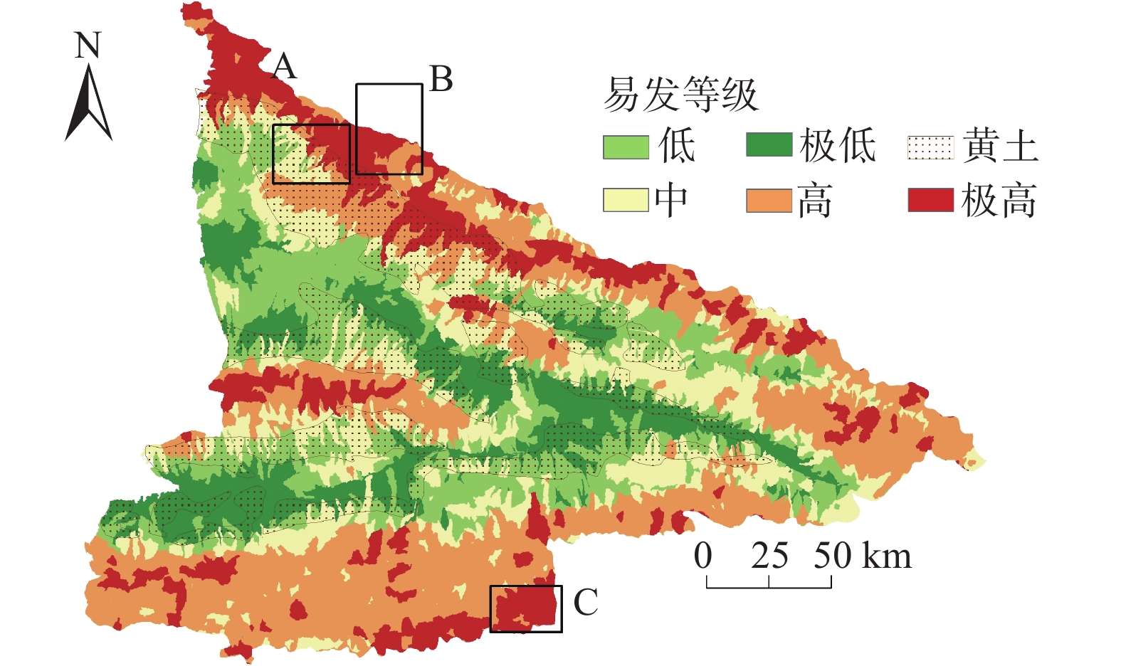
伊犁河谷地处中−哈边境,南北疆结合带,是丝绸之路经济带的前沿,该区域生态环境脆弱,泥石流灾害多发。本研究采用随机森林(RF)、支持向量机(SVM)、逻辑回归(LR)以及决策树(DT)四种机器学习模型,模型输入为遥感判别和野外考察确定的398条泥石流沟以及14个特征参数,计算各个评价因子权重并对泥石流易发性进行评价,最后绘制ROC曲线以及计算曲线下面积(AUC)对四种机器学习的模型的准确性进行评价。研究结果表明:(1)泥石流高易发区主要位于深切河谷地区的天山山地以及山前坡地的黄土覆盖区域;(2)地形起伏度、多年平均降雨量、干旱指数是控制泥石流空间发育的前三个重要因素;(3)四种模型的验证数据集AUC值分别为0.938 (RF)、0.932 (SVM)、0.89 (LR)、0.879(DT),随机森林模型在该区域的易发性评价中具有更好的预测能力;(4)研究区黄土的生态植被被破坏是泥石流多发的重要原因,应该重点进行生态治理和保护,减少水土流失,从源头治理泥石流灾害。
Abstract:The Yili Valley, located on the border between China and Kazakhstan, serves as the juncture of North and South Xinjiang, and stands as a pivotal outpost on the Silk Road Economic Belt. This area possesses a fragile ecological environment and experiences frequent debris flow disasters. In this study, four machine learning models:Random Forest (RF), Logistic Regression (LR), Support Vector Machine (SVM), and Decision Tree (DT)-- were employed to evaluate the debris flow susceptibility and compute the weights of evaluation factors. The models were fed inputs comprising 398 identified debris flow channels and 14 feature parameters such as fault density, topographic relief, land use, NDVI, multi-year average rainfall, etc obtained through remote sensing and field surveys. Also, the accuracy of the four machine learning models was evaluated by ROC curves and calculating the Area Under the Curve (AUC). The research results show that: (1) High debris flow susceptibility areas are mainly located in the Tianshan Mountains in the deep river valley region and the loess-covered areas in the mountain front slopes; (2) Multi-year average rainfall, drought index, and topographic relief variability are the top three influential factors controlling the spatial development of debris flows; (3) The AUC values for the validation datasets of the four models were 0.938 (RF), 0.932 (SVM), 0.89 (LR), 0.79 (DT), with the Random Forest model exhibiting superior predictive capability in assessing susceptibility in the region; (4) The disruption of ecological vegetation in the loess-covered region of the study area is a significant cause of frequent debris flow occurrences. Ecological governance and protection efforts should be emplasized to reduce soil erosion and effectively mitigate debris flow disasters at their source.
-
Keywords:
- debris flow /
- Yili Valley /
- loess /
- susceptibility /
- random forest
-
0. 引言
滑坡是极具破坏性的地质灾害之一,给人类社会造成了巨大的经济损失和人员伤亡,严重威胁人类生命财产安全,制约人类社会的可持续发展[1 − 2]。开展区域滑坡危险性评价,识别滑坡高危险区和阐明地质灾害的潜在分布对地质灾害防治具有重要意义,同时也是决策者预防和减少地质灾害损失的重要手段[3]。
滑坡危险性评价经历了从定性模型到半定量模型再到定量模型的发展过程[4]。定性模型主要是依据专家的知识和野外经验,受主观性限制较多;定量模型主要使用统计或数学建模技术,评价结果具有客观性[5 − 7]。随着科学技术的发展和定量风险管理的需要,滑坡定量评价模型成为主要的研究方向[8 − 10]。常用的定量模型主要包括信息量模型[11 − 12]、确定系数法[13]、逻辑回归模型[14 − 16]、地理加权回归模型[17]、支持向量机模型[18 − 19] 、人工神经网络[20]和随机森林[21 − 22]等模型。上述模型为区域滑坡危险性评价提供了重要参考,已在省、市和县域尺度的地质灾害危险性评价中得到广泛应用[23 − 24]。但在评价过程中,多数研究在定性确定评价因子后,直接应用于危险性评价[25],很少开展评价因子的定量优选工作;各评价因子分级量化主观性较强,评价因子权重赋值多依靠专家经验或先验知识,缺少客观依据[26];运用常权栅格叠加各评价因子时,因子间存在抵消问题和极值区域埋没问题[27]。因此,结合区域滑坡成灾特征建立科学的评价指标体系,构建有效的评价模型是区域滑坡危险性评价的关键问题[28]。
大渡河中游地区位于青藏高原东缘的川西地区,区域地形地貌和地质条件复杂,生态环境较脆弱,气候复杂多变,是我国滑坡地质灾害高发地区[29]。由于地理环境恶劣,地质灾害调查和监测难度大,地质灾害综合防治能力较薄弱。综上,本文以大渡河中游地区为研究区,构建一种基于地理探测器、信息量法和变权栅格叠加的评价模型(geographic detector , information quantity and variable weight raster overlay model,GDIV)。通过地理探测器定量描述各因子对滑坡发生的影响力,基于影响力的显著程度实现评价因子的优选,同时以因子探测结果作为因子定权基础,增强权重的客观性,解决了定性评价因子选择主观性强的问题。采用变权栅格叠加评价因子信息量值,解决了评价因子叠加存在的抵消问题。基于GDIV模型开展区内滑坡危险性评价,评价模型为区域滑坡地质灾害评价提供新参考,评价结果为研究区地质灾害防治提供决策支持。
1. 研究区与数据源
1.1 研究区概况
大渡河中游地区地处四川省阿坝州和甘孜州交界处,区域面积约8 179.6 km2。该区地质构造复杂,包括滇藏“歹”字形构造体系和金汤弧形构造体系,出露的地层主要有三叠系、志留系和泥盆系。地处青藏高原东缘地势一级阶梯向二级阶梯过渡地带,区内海拔1 787~5 782 m,相对高差大。气候以高原型季风气候为主,年平均气温18.4℃,年均降雨量788 mm。区内水系发达,以大渡河为主流,包括革什扎河和东谷河等支流,河流汇集于丹巴县。在复杂的地质地貌条件、降雨和地震等因素影响下,地质灾害发生频繁。大渡河中游地区地质灾害类型主要包括滑坡、崩塌和泥石流,地质灾害详查数据显示,截至2021年12月,区内分布滑坡地质灾害隐患点313处(图1)。滑坡发育规模以中小型为主,大型规模的地质灾害6处,巨型规模的滑坡1处。
![]() 图 1 大渡河中游地区滑坡分布图和地质条件背景图Figure 1. Map of landslide distribution and geological conditions in the middle reach area of Dadu River
图 1 大渡河中游地区滑坡分布图和地质条件背景图Figure 1. Map of landslide distribution and geological conditions in the middle reach area of Dadu River1.2 数据来源及处理
本研究所需的基础数据包括大渡河中游地区滑坡点、地层岩性、土壤类型、数字高程模型和地震动参数等。其中滑坡隐患点数据来源于四川省国土空间生态修复与地质灾害防治研究院1∶50 000地质灾害详查数据;地层岩性和地质构造数据来源于1∶25万炉霍县幅、康定幅和马尔康幅地质图和相关地质报告;降雨量数据来自国家气象科学数据中心—中国气象数据网(http://data.cma.cn/);土壤类型数据来源于中国科学院资源环境科学数据中心(http://www.resdc.cn),基于2010—2020年降雨量插值生成年平均降雨量;数字高程模型(digital elevation model,DEM)和2020年8月两景Landsat8 OLI_TIRS数据来源于地理空间数据云(http://www.gscloud.cn/),空间分辨率30 m。利用DEM生成坡度、坡向、地形湿度指数(TWI)和径流强度指数(SPI),基于Landsat8影像计算归一化植被指数(NDVI)。地震动参数源自中国地震动参数区划图GB 18306—2015(http://www.gb18306.net/)。同时将年平均降雨量、地震动参数等栅格数据统一空间分辨率为30 m,地理参考为WGS_1984_UTM_zone_47N。
2. 研究方法
2.1 滑坡危险性评价初级指标构建
滑坡地质灾害是由内部因素和外部因素共同作用的结果[30],本研究基于区域滑坡发育规律,从地质特征、地震、地形地貌、地表水系、降雨和人类活动等6个方面, 选取13个影响因子构建大渡河中游地区滑坡危险性初级评价指标体系(图2)。其中工程地质岩组分为4类,分别为坚硬岩、较坚硬岩、较软岩、松散土。坚硬岩主要为花岗岩、闪长岩、石英砂岩和石英岩等;较坚硬岩主要为板岩、石英岩状砂岩和硅质岩等;较软岩主要为页岩、千枚岩和粉砂岩等;松散土主要是第四系河漫滩等。
![]() 图 2 大渡河中游地区滑坡危险性初级评价指标体系分级图Figure 2. Grading chart of the primary hazard assessment index system for landslides in the middle reach area of Dadu River Basin
图 2 大渡河中游地区滑坡危险性初级评价指标体系分级图Figure 2. Grading chart of the primary hazard assessment index system for landslides in the middle reach area of Dadu River Basin2.2 地理探测器
将滑坡点密度作为因变量,高程、坡度、坡向、地震动参数、土壤类型、与道路距离和与断层距离等13个因子作为自变量,运用地理探测器的因子探测器和交互探测器对因子进行计算分析。为消除因子类型差异的影响和优化各级因子对地质灾害影响程度的体现,先利用信息量法对自变量进行处理[31]:
$$ {I}\left({X}_{i},Y\right)={\rm{ln}}\frac{P\left(B/{X}_{i}\right)}{P\left(B\right)}={\rm{ln}}\frac{{N}_{i}/N}{{S} _{i}/S} $$ (1) 式中:Xi——成灾因素X中的第i区间;
Y——成灾因素X中第i区间滑坡发生的信息量值;
B——滑坡事件;
Ni——研究区内包含评价因素Xi的单元数且存在滑坡的单元数;
Si——研究区内包含评价因素Xi的单元数;
N——研究区存在滑坡单元总数;
S——研究区中评价单元的总数。
$$ {q=1-}\frac{\displaystyle\sum _{{h=1}}^{{L}}{{N}}_{{h}}{{\sigma}}_{{h}}^{{2}}}{{N}{{\sigma}}^{{2}}}{=1-}\frac{{S S W}}{{S S T}} $$ (2) $$ {S S W=}\sum _{{h=1}}^{{l}}{{N}}_{{h}}{{\sigma}}_{{h}}^{{2}}, {S S T=N}{{\sigma}}^{{2}} $$ (3) 式中:h=1, 2, ···, L——变量Y或因子X的分层;
Nh、N——层h和全区的单元数;
σ2h、σ2——层h和全区的Y值的方差;
SSW、SST——层内方差之和和全区总方差;
q ——因子对滑坡发育的解释力,值域为[0,1],值越大说明对滑坡的影响力越大,因子对滑坡发育的解释力越强。
交互探测器是评估因子X1和X2共同作用时是否会增加或减弱对因变量Y的解释力,或这些因子对Y的影响是相互独立的。因子间若存在交互作用便能通过对比q值体现,交互作用方式的判断依据如表1所示。
表 1 交互作用探测器因子关系Table 1. Factor relationships of interaction detectors因子关系 交互作用 q(X1∩X2)<Min(q(X1), q(X2)) 非线性减弱 Min(q(X1), q(X2))< q(X1∩X2)< Max (q(X1), q(X2)) 单因子非线性减弱 q(X1∩X2)> Max (q(X1), q(X2)) 双因子增强 q(X1∩X2)= q(X1)+q(X2) 独立 q(X1∩X2)> q(X1)+q(X2) 非线性增强 2.3 评价模型
2.3.1 LRI模型
LRI(logistic regression and informative)模型是逻辑回归模型和信息量模型的组合模型,逻辑回归模型是一种对二元分类变量进行回归分析的统计方法,定量描述二元因变量和一系列自变量之间的关系。在危险性评价时,选取评价因子为自变量,以信息量模型计算出的各个指标等级的信息量值表征各评价因子,以区内是否存在滑坡为因变量(1代表存在,0代表不存在)。构建逻辑回归函数:
$$ {P=}\frac{{1}}{{1+}{{{\rm{e}}}}^{{-(\alpha+}{{\beta}}_{{1}}{{X}}_{{1}}+{\cdots}+{{\beta}}_{{n}}{{X}}_{{n}}{)}}} $$ (4) 式中:P——滑坡发生的概率,范围为0~1;
α——截距;
β——回归系数;
i——评价因子种类数目。
将式(5)两边取自然对数ln[P/1−P],将评价因子Xi(i=1, 2, ···, n)作为自变量,建立线性回归方程:
$$ {\ln}\left(\frac{{p}}{{1-p}}\right){=\alpha+}{{\beta}}_{{1}}{{X}}_{{1}}+{{\beta}}_{{2}}{{X}}_{{2}}+\cdots+{{\beta}}_{{n}}{{X}}_{{n}}{=\alpha+\beta X} $$ (5) 2.3.2 变权栅格叠加
变权栅格叠加是变权理论在栅格叠加分析中的应用,该方法根据各叠加图层的初始权重及叠加栅格的像元值,通过一定规则对极值像元进行惩罚型、激励型或混合型变权,可以凸显个别极值栅格的效应[28],实现层内因子重要区间的最大化应用。变权栅格叠加的实现主要包括状态变权函数确定和归一化变权权重计算,其过程如图3所示。图3中,W为各评价因子的初始权重,S(X)是根据状态变权函数获得各图层每个像元的状态变权值,W(X)是各个栅格像元的状态变权值和原始权重值乘积的归一化值,M是所有叠加图层各个栅格像元值和变权权重乘积的综合值。本文的状态变权函数采用局部激励型变权,当信息量值>0.6时,相应权重翻倍,即调权幅度为200%;当信息量值≤0.6时,权重保持不变,即调权幅度为100%。
2.3.3 GDIV模型
GDIV模型是本文提出的地理探测器、信息量法和变权栅格叠加的组合模型,该模型定量描述各因子对滑坡发生的影响力,并以定量结果作为因子定权基础,增强了权重的客观性;同时以变权栅格叠加因子值,消除了因子叠加存在的抵消问题。该模型的实现主要有四步:(1)基于信息量法,对初选因子分级和量化,增强因子各级的差异性;(2)基于地理探测器的因子探测和交互探测结果,选取影响力较强的因子作为评价因子;(3)构建权重方程,见式(6),归一化各评价因子q值以获得权重;(4)确定状态变权函数,生成各因子的变权权重,利用变权栅格叠加实现危险性评价。采用自然间断法将评价结果划分为地质灾害极高、高、中、低和极低5个等级的危险区,实现滑坡危险性评价区划。具体流程如图4所示。
$$ {{ \omega }}_{{i}}=\frac{{{q}}_{{i}}}{\displaystyle\sum _{{i=1}}^{{n}}{{q}}_{{i}}} $$ (6) 式中:ωi——归一化各因子q值所得的权重值;
qi——各因子因子探测q值。
3. 结果与分析
3.1 影响因子分析
3.1.1 影响因子显著性分析
因子探测结果表明,地形地貌、地质特征、人类活动、地表水系、地震和降雨6个方面的因子对地质灾害发生的影响力较大,但各因子对地质灾害发生的解释力存在差异(表2)。高程、土壤类型、年平均降雨量、地震动参数、与河流距离、工程地质岩组和与道路距离对滑坡发生的影响力较显著,这7个因子是滑坡发育的重要因子,其q值均大于0.1,其中高程的平均解释力度为58.3%,土壤类型的平均解释力为41.5%,则高程和土壤类型是研究区滑坡的重要背景因子。与断层距离、归一化植被指数、坡向、径流强度指数和坡度对滑坡发生的解释力度相对一般,q值仅介于0~0.1。地形湿度指数p值大于0.05,未通过显著性检验,该因子对大渡河中游地区滑坡发生的影响程度较小,在本研究中为次要因子。
表 2 滑坡初级评价指标q值统计Table 2. Statistical analysis of primary evaluation index q-values for landslides类别 指标 q值 p值 地质特征 工程地质岩组(X1) 0.156 0.000 与断层距离(X2) 0.087 0.000 地震 地震动参数(X3) 0.164 0.000 地形地貌 高程(X4) 0.583 0.000 坡度(X5) 0.021 0.023 坡向(X6) 0.038 0.003 地形湿度指数(X7) 0.017 0.297 归一化植被指数(X8) 0.072 0.000 土壤类型(X9) 0.415 0.000 地表水系 与河流距离(X10) 0.158 0.000 径流强度指数(X11) 0.032 0.015 降雨 年平均降雨量(X12) 0.182 0.000 人类活动 与道路距离(X13) 0.115 0.000 3.1.2 影响因子交互作用
基于因子探测器中对滑坡发生解释力较强的7个因子,采用交互探测器分析两因子交互作用后对滑坡发育的解释力(表3)。结果显示,21对交互因子中,双因子增强16对,非线性增强5对,不存在相互独立或者非线性减弱的关系,与单因子对滑坡发育的解释力相比,两因子交互作用明显增强了对滑坡发育的解释力。交互作用解释力最高的是高程与工程地质岩组(q=0.736),其次是高程与地震动参数(q=0.676),解释力均高于65% ,两者均是滑坡发生的重要因子组合。高程与土壤类型、工程地质岩组、与道路距离、地震动参数、年平均降雨量、与河流距离均呈现双因子增强作用类型,解释力均在59.6%以上,说明高程增强了土壤类型、工程地质岩组、与道路距离、与河流距离、地震动参数、年平均降雨量对滑坡发生的影响力。土壤类型与地震动参数、工程地质岩组的解释力均大于53%,是滑坡发育的较重要因子组合。从各因子的交互作用结果来看,高程、土壤类型和工程地质岩组等7个因子的协同作用是大渡河中游地区滑坡发生的主导交互作用方式,也是滑坡形成的重要影响因子。
表 3 部分滑坡初级评价指标交互作用Table 3. Interactions of primary evaluation indicators for landslidesXi∩Xj q(Xi) q(Xj) q(Xi∩Xj) q(Xi)+q(Xj) 交互类型 X4∩X1 0.583 0.156 0.736 0.739 双因子增强 X3∩X4 0.164 0.583 0.676 0.747 双因子增强 X9∩X4 0.415 0.583 0.596 0.998 双因子增强 X10∩X4 0.158 0.583 0.603 0.741 双因子增强 X13∩X4 0.115 0.583 0.597 0.698 双因子增强 X12∩X4 0.182 0.583 0.672 0.765 双因子增强 X9∩X3 0.415 0.164 0.537 0.579 双因子增强 X9∩X1 0.415 0.156 0.555 0.571 双因子增强 X9∩X10 0.415 0.158 0.434 0.573 双因子增强 X9∩X13 0.415 0.115 0.428 0.53 双因子增强 X9∩X12 0.415 0.182 0.527 0.597 双因子增强 X10∩X3 0.158 0.164 0.312 0.322 双因子增强 X10∩X1 0.158 0.156 0.344 0.314 非线性增强 X13∩X3 0.115 0.164 0.276 0.279 双因子增强 X13∩X1 0.115 0.156 0.278 0.271 非线性增强 X3∩X1 0.164 0.156 0.329 0.320 非线性增强 X13∩X10 0.115 0.158 0.226 0.273 双因子增强 X10∩X12 0.158 0.182 0.343 0.340 非线性增强 X13∩X12 0.115 0.182 0.292 0.297 双因子增强 X3∩X12 0.164 0.182 0.269 0.346 双因子增强 X12∩X1 0.182 0.156 0.348 0.338 非线性增强 3.2 评价因子优化与分析
通过地理探测器分析了研究区内高程、土壤类型和工程地质岩组等13个因子与滑坡发生频率变化关系, 结合因子探测器和交互探测器结果,最终选定影响力较强和交互作用显著的7个因子作为大渡河中游地区滑坡危险性评价因子,即高程、年平均降雨量、土壤类型、地震动参数、与道路距离、工程地质岩组和与河流距离。
通过式(1)得到各评价因子信息量值(表4),其中高程值<2700 m的区间信息量值大于2,表明区内滑坡主要发生在高程值<2700 m的区间;土壤类型为淋溶土和人为土的区间信息量值大于1,表明区内滑坡主要发生在这两类土壤中。工程地质岩组通过基岩和堆积体的物理力学性质来影响滑坡发生,区内较软岩的信息量值大于1.8,意味着较软岩分布区更有利于滑坡的发生。归一化植被指数、与河流距离、地震动参数和与道路距离是滑坡形成的重要因子,年平均降雨量在750~775时,信息量值最大;道路在建设中因剥离地表土壤和松散岩石对周边环境产生影响,区内滑坡发生概率与道路距离成负相关关系。区内与道路距离小于100 m的缓冲区信息量值最高,随着与道路距离的增加信息量值依次递减。
表 4 危险性评价因子分级与信息量值Table 4. Grading and information value of hazard evaluation factors评价因子 分级 信息量值 评价因子 分级 信息量值 高程/m <2 700 2.058 年平均
降雨量/mm<750 −0.557 2 700~3 200 1.308 750~775 0.438 3 200~3 600 −1.37 775~800 −1.014 3 600~4 000 −2.445 800~840 −0.055 4 000~4 400 −3.76 840~880 −0.404 > 4400 — >880 −0.231 土壤类型 淋溶土 1.685 地震动
参数<0.1 0.151 半淋溶土 — 0.1~0.15 0.464 初育土 −3.921 0.15~0.2 −1.059 高山土 0.107 0.2~0.3 — 人为土 1.429 与道路
距离/m<100 1.500 铁铝土 0.890 100~200 1.227 与河流
距离/m<400 −1.204 200~300 1.148 400~800 −0.826 300~400 1.053 800~1 200 −0.025 400~500 0.789 1 200~1 600 0.004 >500 −0.335 1 600~2 000 0.577 >2 000 1.038 工程地质
岩组坚硬岩 0.023 较坚硬岩 0.443 较软岩 1.878 松散土类 −1.086 3.3 滑坡危险性评价
3.3.1 LRI模型滑坡危险性评价
基于大渡河中游地区各评价因子的信息量值,运用LRI模型分析得到各因子的逻辑回归系数值(表5)。结果表明,各评价因子的显著性水平值均小于0.05,通过显著性检验。各评价因子的回归系数均为正值,表明各评价因子对滑坡发生均具有促进作用。高程的回归系数最大(B=4.992),区内地质灾害的发生与高程相关程度最大。其次是土壤类型(B=3.001)、工程地质岩组(B=1.606)、年平均降雨量(B=1.103)、与道路距离(B=0.995)和地震动参数(B=0.802),回归系数均大于0.8,对滑坡的发生具有较强的影响。基于各因子的回归系数构建线性回归方程,实现区内滑坡危险性评价,见图5(a)。评价结果表明,随着危险等级的降低对应区内的面积逐步增加,其中极高和高危险的面积占比为18.1%,分布295处滑坡,随着危险等级的降低对应区内的滑坡点也逐渐减少。
表 5 滑坡危险性评价因子逻辑回归分析结果Table 5. Results of logistic regression analysis for landslide hazard evaluation factors评价因子 B SE Wald df sig Exp(B) 高程 4.992 0.551 82.210 1 0.000 147.24 土壤类型 3.001 0.550 29.785 1 0.000 20.110 工程地质岩组 1.606 0.837 3.387 1 0.000 4.666 年平均降雨量 1.103 0.379 8.468 1 0.000 3.013 与道路距离 0.995 0.396 2.573 1 0.000 2.435 地震动参数 0.802 0.469 1.657 1 0.000 1.830 与河流距离 0.148 0.398 5.259 1 0.001 0.739 常数 −7.132 0.696 104.815 1 0.000 0.001 注:B为模型中各变量的回归系数、SE是标准差、Wald是卡方统计、Sig为显著性水平,df和Exp(B)为逻辑回归的结果参数。 3.3.2 GDIV模型滑坡危险性评价
利用式(6)获得各评价因子权重(表6),经变权栅格叠加实现基于GDIV模型的滑坡危险性评价(图5b)。结果表明,各评价因子的权重大小顺序为:高程(0.329)>土壤类型(0.234)>年平均降雨量(0.103)>地震动参数(0.092)>与河流距离(0.089)>工程地质岩组(0.088)>与道路距离(0.065)。研究区极高和高危险区分布滑坡共302处,占总地质灾害的96.5%。其中极高危险区滑坡数量占比为65.5%,高危险区滑坡数量占比为31%,中等及以下危险区滑坡发育较少。随滑坡危险等级的降低,对应区内的滑坡点数量也依次减少,评价结果与实际情况相符。滑坡危险性等级从低到高的各区面积占比分别是25.2%(极低)、40%(低)、13.2%(中)、11.2%(高)和10.5%(极高)。GDIV模型充分考虑因子间的抵消效应和极值埋没问题,变权栅格叠加评价因子的综合信息量值在极值区间占比较小,极低危险区面积占比小于低危险区。极高危险区和高危险区主要沿东谷河、大渡河和革什扎河两侧分布,区内海拔小于3200 m,以淋溶土为主,人类活动频繁。低危险区和极低危险区主要分布在水系发育程度较低、海拔相对较高和距交通干线相对较远的地区,集中分布在大渡河中游地区的阿科里乡、毛日乡、丹东乡、银恩乡、七美乡和协德乡等地。
表 6 滑坡危险性评价因子权重值Table 6. Weight values of landslide hazard assessment factors因子 q值 权重 高程 0.583 0.329 土壤类型 0.415 0.234 年平均降雨量 0.182 0.103 地震动参数 0.164 0.092 与河流距离 0.158 0.089 工程地质岩组 0.156 0.088 与道路距离 0.115 0.065 3.4 精度验证
基于ROC曲线对GDIV模型和LRI模型滑坡危险性评价结果进行精度验证和对比分析。研究区共分布滑坡点313处,在研究区生成313处随机点作为非灾害样本点合并绘制ROC曲线(图6)。LRI模型的AUC值为0.903,标准误差为0.013,在满足显著性条件下AUC值最高可大0.929。GDIV模型的AUC值为0.917,标准误差为0.012,在满足显著性条件下AUC值最高可大0.941。两种模型的评价效果均较好,但GDIV模型的评价精度相对较高。由此表明基于GDIV模型的滑坡危险性评价方法在大渡河中游地区的实用性更好,能较好地评估滑坡危险情况。
4. 结论
本文以大渡河中游地区为研究区,初选高程、土壤类型和与河流距离等13个因子构建初级评价指标体系,利用地理探测器和信息量法实现因子的筛选和优化,构建GDIV模型开展研究区滑坡危险性评价,为验证模型的精度引入LRI模型,基于ROC曲线对比分析和验证两种模型的评价精度,得出以下结论。
(1)地理探测器结果表明,高程(q=0.583)和土壤类型(q=0.415)是区内滑坡危险性的重要背景因素,高程与工程地质岩组(q=0.736)、高程与地震动参数(q=0.676)、高程与年平均降雨量(q=0.672)的协同作用对滑坡的发生具有重要影响。
(2)基于GDIV模型的大渡河中游地区滑坡危险性评价结果显示,区内大部分地区为中度及以下危险区,面积占比为78.3%;而极高和高危险区面积占比为21.7%。极高危险区主要集中分布在河谷地区,工程地质岩组为松散土类均分布在该区内,土壤类型为淋溶土;高危险区要分布在东谷河、大渡河和革什扎河两侧极高危险区以外的区域;中危险区主要集中在海拔3200~4000 m范围内,极低和低危险区主要集中在人口稀少的高海拔区域。
(3)GDIV模型(AUC=0.917)评价精度高于LRI模型(AUC=0.903),在极高危险区和高危险区内GDIV模型所含滑坡点总量较LRI模型多7处。GDIV模型评价结果更符合区内滑坡分布情况,该模型适用于大渡河中游地区滑坡危险性评价。
-
![]()
图 4 致灾因子空间分布特征
Figure 4. Spatial distribution characteristics of disaster-causing factors
![]()
图 5 致灾因子Person相关系数热力图
Figure 5. Heatmap of person correlation coefficients of the causative factor
![]()
图 7 不同模型致灾因子贡献重要性
Figure 7. Importance of causative factors contribution in different models
表 1 泥石流致灾因子多源异构数据来源
Table 1 Multi sources of heterogeneous data for debris flow causation factors
因子 因子(英文) 格式、分辨率/m 数据来源 流域面积 AREA shape file GIS分析及目视解译 高差 HD shape file SRTM-30 m GIS分析 坡度 Slope Tiff/30×30 SRTM-30 m GIS分析 地形起伏度 RDLS Tiff/30×30 SRTM-30 m GIS分析 高程变异系数 EVC Tiff/30×30 SRTM-30 m GIS分析 归一化植被指数 NDVI Tiff/500×500 MODIS植被指数产品(1990—2020年)(https://modis.gsfc.nasa.gov/data/dataprod/mod13.php) 地层岩性 RS shape file 地质云1∶20万地质图 土地利用类型 LC Tiff/30×30 欧空局Release of Esa's Worldcover MAP(https://esa-worldcover.org/en/data-access) 断层密度 FD shape file 地质云1∶20万地质图 地形湿度指数 TWI Tiff/30×30 SRTM-30 m GIS分析 道路密度 RD shape file 1∶25万全国基础地理数据库(https://www.webmap.cn/) 多年平均年降雨量 AAP Tiff/30×30 Google erath engine 下载CHIRPS Daily: Climate Hazards Group InfraRed Precipitation
With Station Data(Version 2.0 Final)数据集(https://earthengine.google.com/)归一化差异积雪指数 NDSI Tiff/500×500 MODIS/Terra Snow Cover Daily L3 Global 500m SIN Grid, Version 6 (MOD10A1) (https://modis.gsfc.nasa.gov/data/dataprod/mod13.php) 干旱指数 KBDI Tiff/1000×1000 Google erath engine 下载Keetch-Byram Drought Index数据集
(https://earthengine.google.com/) 下载: 导出CSV
表 2 四种模型易发性分区统计
Table 2 Statistical analysis of susceptibility zoning using four models
模型 易发性分区 面积/km2 面积占比/% 分区内泥石流条数/条 泥石流条数占比/% 随机森林 极高 7971.642 14.11 143 35.93 高 17701.790 31.33 177 44.47 中 11144.620 19.72 46 11.56 低 11751.190 20.80 23 5.78 极低 7930.759 14.04 9 2.26 支持向量机 极高 7689.020 13.61 152 38.19 高 17493.350 30.96 169 42.46 中 11457.150 20.28 45 11.31 低 11635.640 20.59 23 5.78 极低 8224.840 14.56 9 2.26 逻辑回归 极高 7634.988 13.51 127 31.91 高 16051.380 28.41 178 44.72 中 10676.710 18.90 50 12.56 低 12377.990 21.91 28 7.04 极低 9758.932 17.27 15 3.77 决策树 极高 6979.475 12.35 129 32.41 高 16973.330 30.04 175 43.97 中 11080.390 19.61 56 14.07 低 11712.370 20.73 26 6.53 极低 9754.436 17.26 12 3.02
下载: 导出CSV
-
[1] 陈宁生,田树峰,张勇,等. 泥石流灾害的物源控制与高性能减灾[J]. 地学前缘,2021,28(4):337 − 348. [CHEN Ningsheng,TIAN Shufeng,ZHANG Yong,et al. Soil mass domination in debris-flow disasters and strategy for hazard mitigation[J]. Earth Science Frontiers,2021,28(4):337 − 348. (in Chinese with English abstract)] DOI: 10.13745/j.esf.sf.2020.6.39 CHEN Ningsheng, TIAN Shufeng, ZHANG Yong, et al. Soil mass domination in debris-flow disasters and strategy for hazard mitigation[J]. Earth Science Frontiers, 2021, 28(4): 337 − 348. (in Chinese with English abstract) DOI: 10.13745/j.esf.sf.2020.6.39
[2] 宋友桂,史正涛. 伊犁盆地黄土分布与组成特征[J]. 地理科学,2010,30(2):267 − 272. [SONG Yougui,SHI Zhengtao. Distribution and compositions of loess sediments in Yili Basin,central Asia[J]. Scientia Geographica Sinica,2010,30(2):267 − 272. (in Chinese with English abstract)] DOI: 10.13249/j.cnki.sgs.2010.02.011 SONG Yougui, SHI Zhengtao. Distribution and compositions of loess sediments in Yili Basin, central Asia[J]. Scientia Geographica Sinica, 2010, 30(2): 267 − 272. (in Chinese with English abstract) DOI: 10.13249/j.cnki.sgs.2010.02.011
[3] 邵海,魏云杰,黄喆,等. 新疆伊宁克孜勒赛黄土滑坡堵溃型泥石流成灾模式[J]. 中国地质灾害与防治学报,2018,29(6):40 − 46. [SHAO Hai,WEI Yunjie,HUANG Zhe,et al. Kezilesai loess landslide dam-breaking debris flow hazards model in Yining County,Xinjiang[J]. The Chinese Journal of Geological Hazard and Control,2018,29(6):40 − 46. (in Chinese with English abstract)] DOI: 10.16031/j.cnki.issn.1003-8035.2018.06.06 SHAO Hai, WEI Yunjie, HUANG Zhe, et al. Kezilesai loess landslide dam-breaking debris flow hazards model in Yining County, Xinjiang[J]. The Chinese Journal of Geological Hazard and Control, 2018, 29(6): 40 − 46. (in Chinese with English abstract) DOI: 10.16031/j.cnki.issn.1003-8035.2018.06.06
[4] AHMED B,DEWAN A. Application of bivariate and multivariate statistical techniques in landslide susceptibility modeling in Chittagong City corporation,Bangladesh[J]. Remote Sensing,2017,9(4):304. DOI: 10.3390/rs9040304
[5] LI Yongchao,CHEN Jianping,TAN Chun,et al. Application of the borderline-SMOTE method in susceptibility assessments of debris flows in Pinggu District,Beijing,China[J]. Natural Hazards,2021,105(3):2499 − 2522. DOI: 10.1007/s11069-020-04409-7
[6] 徐艳琴,白淑英,徐永明. 基于两种方法的攀西泥石流易发性评价对比分析[J]. 水土保持研究,2018,25(3):285 − 291. [XU Yanqin,BAI Shuying,XU Yongming. Comparative analysis of debris flow susceptibility assessment based on two methods in Panxi District[J]. Research of Soil and Water Conservation,2018,25(3):285 − 291. (in Chinese with English abstract)] DOI: 10.13869/j.cnki.rswc.2018.03.040 XU Yanqin, BAI Shuying, XU Yongming. Comparative analysis of debris flow susceptibility assessment based on two methods in Panxi District[J]. Research of Soil and Water Conservation, 2018, 25(3): 285 − 291. (in Chinese with English abstract) DOI: 10.13869/j.cnki.rswc.2018.03.040
[7] LIANG Zhu,WANG Changming,ZHANG Zhimin,et al. A comparison of statistical and machine learning methods for debris flow susceptibility mapping[J]. Stochastic Environmental Research and Risk Assessment,2020,34(11):1887 − 1907. DOI: 10.1007/s00477-020-01851-8
[8] 黄发明,胡松雁,闫学涯,等. 基于机器学习的滑坡易发性预测建模及其主控因子识别[J]. 地质科技通报,2022,41(2):79 − 90. [HUANG Faming,HU Songyan,YAN Xueya,et al. Landslide susceptibility prediction and identification of its main environmental factors based on machine learning models[J]. Bulletin of Geological Science and Technology,2022,41(2):79 − 90. (in Chinese with English abstract)] HUANG Faming, HU Songyan, YAN Xueya, et al. Landslide susceptibility prediction and identification of its main environmental factors based on machine learning models[J]. Bulletin of Geological Science and Technology, 2022, 41(2): 79 − 90. (in Chinese with English abstract)
[9] 刘永垚,第宝锋,詹宇,等. 基于随机森林模型的泥石流易发性评价——以汶川地震重灾区为例[J]. 山地学报,2018,36(5):765 − 773. [LIU Yongyao,DI Baofeng,ZHAN Yu,et al. Debris flows susceptibility assessment in Wenchuan earthquake areas based on random forest algorithm model[J]. Mountain Research,2018,36(5):765 − 773. (in Chinese with English abstract)] DOI: 10.16089/j.cnki.1008-2786.000372 LIU Yongyao, DI Baofeng, ZHAN Yu, et al. Debris flows susceptibility assessment in Wenchuan earthquake areas based on random forest algorithm model[J]. Mountain Research, 2018, 36(5): 765 − 773. (in Chinese with English abstract) DOI: 10.16089/j.cnki.1008-2786.000372
[10] DI Baofeng,ZHANG Hanyue,LIU Yongyao,et al. Assessing susceptibility of debris flow in southwest China using gradient boosting machine[J]. Scientific Reports,2019,9:12532. DOI: 10.1038/s41598-019-48986-5
[11] QING Feng,ZHAO Yan,MENG Xingmin,et al. Application of machine learning to debris flow susceptibility mapping along the china–pakistan karakoram highway[J]. Remote Sensing,2020,12(18):2933. DOI: 10.3390/rs12182933
[12] MARINO P,SIVA SUBRAMANIAN S,FAN Xuanmei,et al. Changes in debris-flow susceptibility after the Wenchuan earthquake revealed by meteorological and hydro-meteorological thresholds[J]. CATENA,2022,210:105929. DOI: 10.1016/j.catena.2021.105929
[13] ESPER ANGILLIERI M Y. Debris flow susceptibility mapping using frequency ratio and seed cells,in a portion of a mountain international route,dry central andes of argentina[J]. CATENA,2020,189:104504. DOI: 10.1016/j.catena.2020.104504
[14] 李郎平,兰恒星,郭长宝,等. 基于改进频率比法的川藏铁路沿线及邻区地质灾害易发性分区评价[J]. 现代地质,2017,31(5):911 − 929. [LI Langping,LAN Hengxing,GUO Changbao,et al. Geohazard susceptibility assessment along the sichuan-tibet railway and its adjacent area using an improved frequency ratio method[J]. Geoscience,2017,31(5):911 − 929. (in Chinese with English abstract)] DOI: 10.3969/j.issn.1000-8527.2017.05.004 LI Langping, LAN Hengxing, GUO Changbao, et al. Geohazard susceptibility assessment along the sichuan-tibet railway and its adjacent area using an improved frequency ratio method[J]. Geoscience, 2017, 31(5): 911 − 929. (in Chinese with English abstract) DOI: 10.3969/j.issn.1000-8527.2017.05.004
[15] WANG Jun,YU Yan,YANG Shun,et al. A modified certainty coefficient method (M-CF) for debris flow susceptibility assessment:A case study for the Wenchuan earthquake meizoseismal areas[J]. Journal of Mountain Science,2014,11(5):1286 − 1297. DOI: 10.1007/s11629-013-2781-7
[16] 陈宁生,邓明枫,胡桂胜,等. 地震影响下西南干旱山区泥石流危险性特征与防治对策[J]. 四川大学学报(工程科学版),2010,42(增刊1):1 − 6. [CHEN Ningsheng,DENG Mingfeng,HU Guisheng,et al. Risk characteristics and prevention strategy of debris flow under the seismic influence in mountainous arid area,southwest China[J]. Journal of Sichuan University (Engineering Science Edition),2010,42(Sup 1):1 − 6. (in Chinese with English abstract)] CHEN Ningsheng, DENG Mingfeng, HU Guisheng, et al. Risk characteristics and prevention strategy of debris flow under the seismic influence in mountainous arid area, southwest China[J]. Journal of Sichuan University (Engineering Science Edition), 2010, 42(Sup 1): 1 − 6. (in Chinese with English abstract)
[17] SONG Yougui,SHI Zhengtao,FANG Xiaomin,et al. Loess magnetic properties in the Ili Basin and their correlation with the Chinese Loess Plateau[J]. Science China Earth Sciences,2010,53(3):419 − 431. DOI: 10.1007/s11430-010-0011-5
[18] 张军民. 伊犁河流域地质构造及其地形地貌特点的研究[J]. 石河子大学学报(自然科学版),2006,24(4):442 − 445. [ZHANG Junmin. Studies on the geological structures and characteristic of terrain and landform in Yili River Basin[J]. Journal of Shihezi University (Natural Science),2006,24(4):442 − 445. (in Chinese with English abstract)] DOI: 10.3969/j.issn.1007-7383.2006.04.013 ZHANG Junmin. Studies on the geological structures and characteristic of terrain and landform in Yili River Basin[J]. Journal of Shihezi University (Natural Science), 2006, 24(4): 442 − 445. (in Chinese with English abstract) DOI: 10.3969/j.issn.1007-7383.2006.04.013
[19] 屈文军,张小曳,王丹,等. 西风带研究的重要意义[J]. 海洋地质与第四纪地质,2004,24(1):125 − 132. [QU Wenjun,ZHANG Xiaoye,WANG Dan,et al. The important significance of westerly wind study[J]. Marine Geology & Quaternary Geology,2004,24(1):125 − 132. (in Chinese with English abstract)] DOI: 10.16562/j.cnki.0256-1492.2004.01.018 QU Wenjun, ZHANG Xiaoye, WANG Dan, et al. The important significance of westerly wind study[J]. Marine Geology & Quaternary Geology, 2004, 24(1): 125 − 132. (in Chinese with English abstract) DOI: 10.16562/j.cnki.0256-1492.2004.01.018
[20] SUN Huilan,CHEN Yaning,LI Weihong,et al. Variation and abrupt change of climate in Ili River Basin,Xinjiang[J]. Journal of Geographical Sciences,2010,20(5):652 − 666. DOI: 10.1007/s11442-010-0802-9
[21] 冯建辉,陶国强,梅志超,等. 新疆伊犁盆地地层划分与对比[J]. 断块油气田,1996,3(3):22 − 28. [FENG Jianhu,TAO Guoqiang,MEI Zhichao,et al. Stratigraphic classification and correlation in Yili Basin,Xinjiang[J]. Fault-Block Oil & Gas Field,1996,3(3):22 − 28.(in Chinese with English abstract)] FENG Jianhu, TAO Guoqiang, MEI Zhichao, et al. Stratigraphic classification and correlation in Yili Basin, Xinjiang[J]. Fault-Block Oil & Gas Field, 1996, 3(3): 22 − 28.(in Chinese with English abstract)
[22] KORNEJADY A,OWNEGH M,BAHREMAND A. Landslide susceptibility assessment using maximum entropy model with two different data sampling methods[J]. CATENA,2017,152:144 − 162. DOI: 10.1016/j.catena.2017.01.010
[23] 张明媚,薛永安. 斜坡地质灾害敏感性评价中地势起伏度提取最佳尺度研究[J]. 太原理工大学学报,2020,51(6):881 − 888. [ZHANG Mingmei,XUE Yongan. Optimal scale for extracting relief amplitude in slope geological hazard sensitivity evaluation[J]. Journal of Taiyuan University of Technology,2020,51(6):881 − 888. (in Chinese with English abstract)] DOI: 10.16355/j.cnki.issn1007-9432tyut.2020.06.015 ZHANG Mingmei, XUE Yongan. Optimal scale for extracting relief amplitude in slope geological hazard sensitivity evaluation[J]. Journal of Taiyuan University of Technology, 2020, 51(6): 881 − 888. (in Chinese with English abstract) DOI: 10.16355/j.cnki.issn1007-9432tyut.2020.06.015
[24] 张伟,李爱农. 基于DEM的中国地形起伏度适宜计算尺度研究[J]. 地理与地理信息科学,2012,28(4):8 − 12. [ZHANG Wei,LI Ainong. Study on the optimal scale for calculating the relief amplitude in China based on DEM[J]. Geography and Geo-Information Science,2012,28(4):8 − 12. (in Chinese with English abstract)] ZHANG Wei, LI Ainong. Study on the optimal scale for calculating the relief amplitude in China based on DEM[J]. Geography and Geo-Information Science, 2012, 28(4): 8 − 12. (in Chinese with English abstract)
[25] 杨晓平,王萍,李晓峰,等. 地形坡度和高程变异系数在识别墨脱活动断裂带中的应用[J]. 地震地质,2019,41(2):419 − 435. [YANG Xiaoping,WANG Ping,LI Xiaofeng,et al. Application of topographic slope and elevation variation coefficient in identifying the Motuo active fault zone[J]. Seismology and Geology,2019,41(2):419 − 435. (in Chinese with English abstract)] YANG Xiaoping, WANG Ping, LI Xiaofeng, et al. Application of topographic slope and elevation variation coefficient in identifying the Motuo active fault zone[J]. Seismology and Geology, 2019, 41(2): 419 − 435. (in Chinese with English abstract)
[26] 高云建,陈宁生,胡桂胜,等. 西南山区泥石流灾害与厄尔尼诺-拉尼娜事件时空耦合关系分析[J]. 长江科学院院报,2019,36(4):43 − 48. [GAO Yunjian,CHEN Ningsheng,HU Guisheng,et al. Temporal and spatial coupling relationship between debris flow and El Nino-La nina event in southwest China[J]. Journal of Yangtze River Scientific Research Institute,2019,36(4):43 − 48. (in Chinese with English abstract)] GAO Yunjian, CHEN Ningsheng, HU Guisheng, et al. Temporal and spatial coupling relationship between debris flow and El Nino-La nina event in southwest China[J]. Journal of Yangtze River Scientific Research Institute, 2019, 36(4): 43 − 48. (in Chinese with English abstract)
[27] 于新洋,赵庚星,常春艳,等. 随机森林遥感信息提取研究进展及应用展望[J]. 遥感信息,2019,34(2):8 − 14. [YU Xinyang,ZHAO Gengxing,CHANG Chunyan,et al. Random forest classifier in remote sensing information extraction:A review of applications and future development[J]. Remote Sensing Information,2019,34(2):8 − 14. (in Chinese with English abstract)] YU Xinyang, ZHAO Gengxing, CHANG Chunyan, et al. Random forest classifier in remote sensing information extraction: A review of applications and future development[J]. Remote Sensing Information, 2019, 34(2): 8 − 14. (in Chinese with English abstract)
[28] 黄发明,殷坤龙,蒋水华,等. 基于聚类分析和支持向量机的滑坡易发性评价[J]. 岩石力学与工程学报,2018,37(1):156 − 167. [HUANG Faming,YIN Kunlong,JIANG Shuihua,et al. Landslide susceptibility assessment based on clustering analysis and support vector machine[J]. Chinese Journal of Rock Mechanics and Engineering,2018,37(1):156 − 167. (in Chinese with English abstract)] DOI: 10.13722/j.cnki.jrme.2017.0824 HUANG Faming, YIN Kunlong, JIANG Shuihua, et al. Landslide susceptibility assessment based on clustering analysis and support vector machine[J]. Chinese Journal of Rock Mechanics and Engineering, 2018, 37(1): 156 − 167. (in Chinese with English abstract) DOI: 10.13722/j.cnki.jrme.2017.0824
[29] PROVOST F J,FAWCETT T. Robust classification for imprecise environments[J]. Machine Learning,2001,42(3):203 − 231. DOI: 10.1023/A:1007601015854
[30] 王凤娘. 2010年极端干湿循环对我国西南山区大规模泥石流滑坡灾害的促进作用[C]//2015年全国工程地质学术年会论文集. 长春,2015:73 − 79. [WANG fengniang. Promoting impact of extreme dry-wet cycle in 2010 on the large-scale debris flows and landslides in southwest mountain areas of china[C]//Proceedings of the 2015 National Annual Conference on Engineering Geology. Changchun, 2015: 73 − 79. (in Chinese with English abstract)] WANG fengniang. Promoting impact of extreme dry-wet cycle in 2010 on the large-scale debris flows and landslides in southwest mountain areas of china[C]//Proceedings of the 2015 National Annual Conference on Engineering Geology. Changchun, 2015: 73 − 79. (in Chinese with English abstract)
[31] BREIMAN L. Random forests[J]. Machine Learning,2001,45(1):5 − 32. DOI: 10.1023/A:1010933404324
-
期刊类型引用(1)
1. 苏娜,徐林荣,李永威,李佳珅,汤玉兰. 汶川地震震后七盘沟泥石流动态物源危险性评价. 中国地质灾害与防治学报. 2025(01): 16-27 .  本站查看
本站查看
其他类型引用(0)


计量
- 文章访问数: 867
- HTML全文浏览量: 984
- PDF下载量: 160
- 被引次数: 1
 邮件订阅
邮件订阅 RSS
RSS