
Current application of machine learning models in the analysis of remote sensing survey data for geological hazards
-
摘要:
为研究机器学习模型在地质灾害遥感调查中的应用现状,基于中国知网(CNKI)数据库,采用文献计量法进行可视化分析,从发文量、研究热点、研究机构等多视角详述机器学习模型、地质灾害遥感调查技术的研究进展。利用VOSviewer软件分析机器学习模型与地质灾害遥感调查技术高频关键词及其关联度,并通过分类统计定量化分析得出研究热点、关联性和发展趋势。结果表明:中国地质灾害遥感调查技术正由“图谱测量”向“图谱与几何测量”逐步转变,新一代机器学习算法伴随着无人机遥感技术的进步,已成为本领域最热门的研究方向,推动着地质灾害体自动识别和智能提取技术发展;未来的地质灾害遥感调查技术必然是围绕“空−天−地”协同应用与应急监测的综合技术体系。研究认为,针对不同遥感影像数据的特点,综合研究不同机器学习模型在各种遥感解译工作场景中的应用是未来的主要发展趋势。
Abstract:To investigate the current landscape of the application of machine learning in remote sensing surveys of geological disasters and to support the development of intelligent remote sensing survey technologies for geological disasters, a bibliometric analysis of machine learning and geological disaster remote sensing survey technology was conducted using the China National Knowledge Infrastructure (CNKI) database. Visual analysis was performed from multiple perspectives, including the number of publications, research hotspots, and research institutions, to describe the research progress of machine learning and geological disaster remote sensing survey technology. VOSviewer software was utilized to scrutinize the high-frequency keywords and their associations between machine learning and geological disaster remote sensing survey technology. The results showed that remote sensing survey technology for geological disasters in China is gradually shifting from traditional “topographic measurement” towards more holistic “topographic and geometric measuremen” approaches. With the advancement of unmanned aerial vehicle remote sensing technology, the new generation of intelligent learning algorithms have emerged as the predominant research direction, fostering the growth of automated geological disaster recognition and intelligent extraction techniques. Nevertheless, the future of remote sensing survey technology for geological disasters is poised to evolve into a comprehensive technical system that emphasizes the synergistic “air-space-ground” application and emergency monitoring. Considering the diverse characteristics of remote sensing image data, the primary developmental trajectory will involve an extensive exploration of various machine learning algorithms across different remote sensing interpretation scenarios.
-
Keywords:
- geologic hazard /
- remote sensing /
- machine learning /
- bibliometrics
-
-
![]()
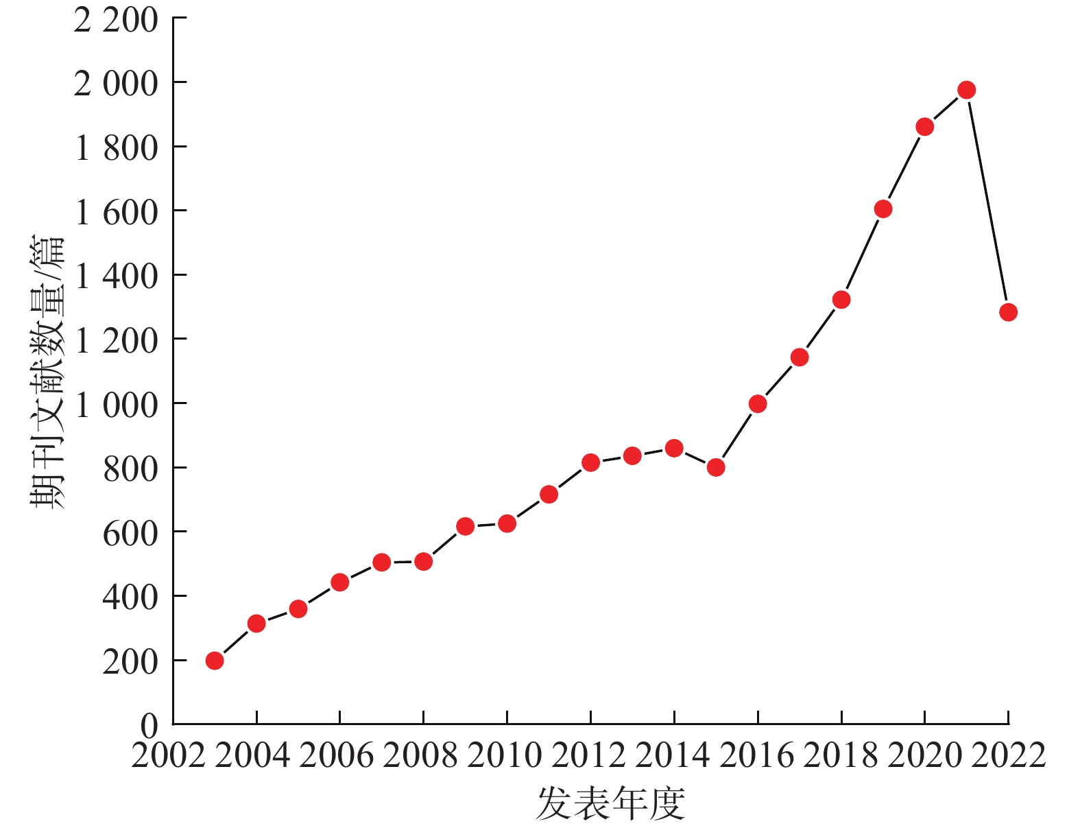
图 1 2003—2022年地质灾害遥感调查技术应用研究领域发文量分布
Figure 1. Distribution of published papers in the fields of geological hazard remote sensing survey technology application from 2003 to 2022
![]()
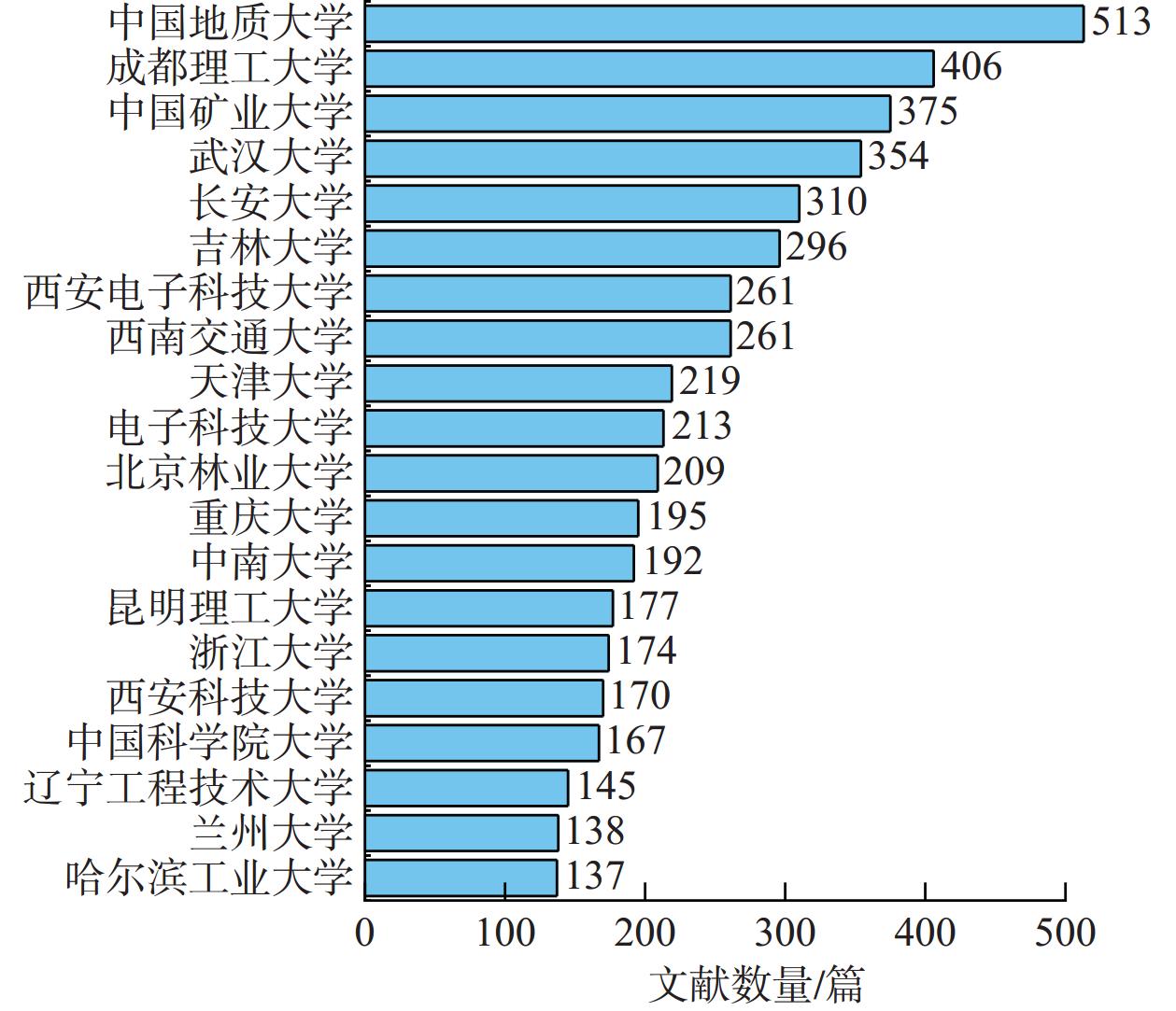
图 2 2003—2022年地质灾害遥感调查技术应用研究领域高发文机构
Figure 2. High-volume institutions in the field of geological hazard remote sensing survey technology application research from 2003 to 2022
![]()
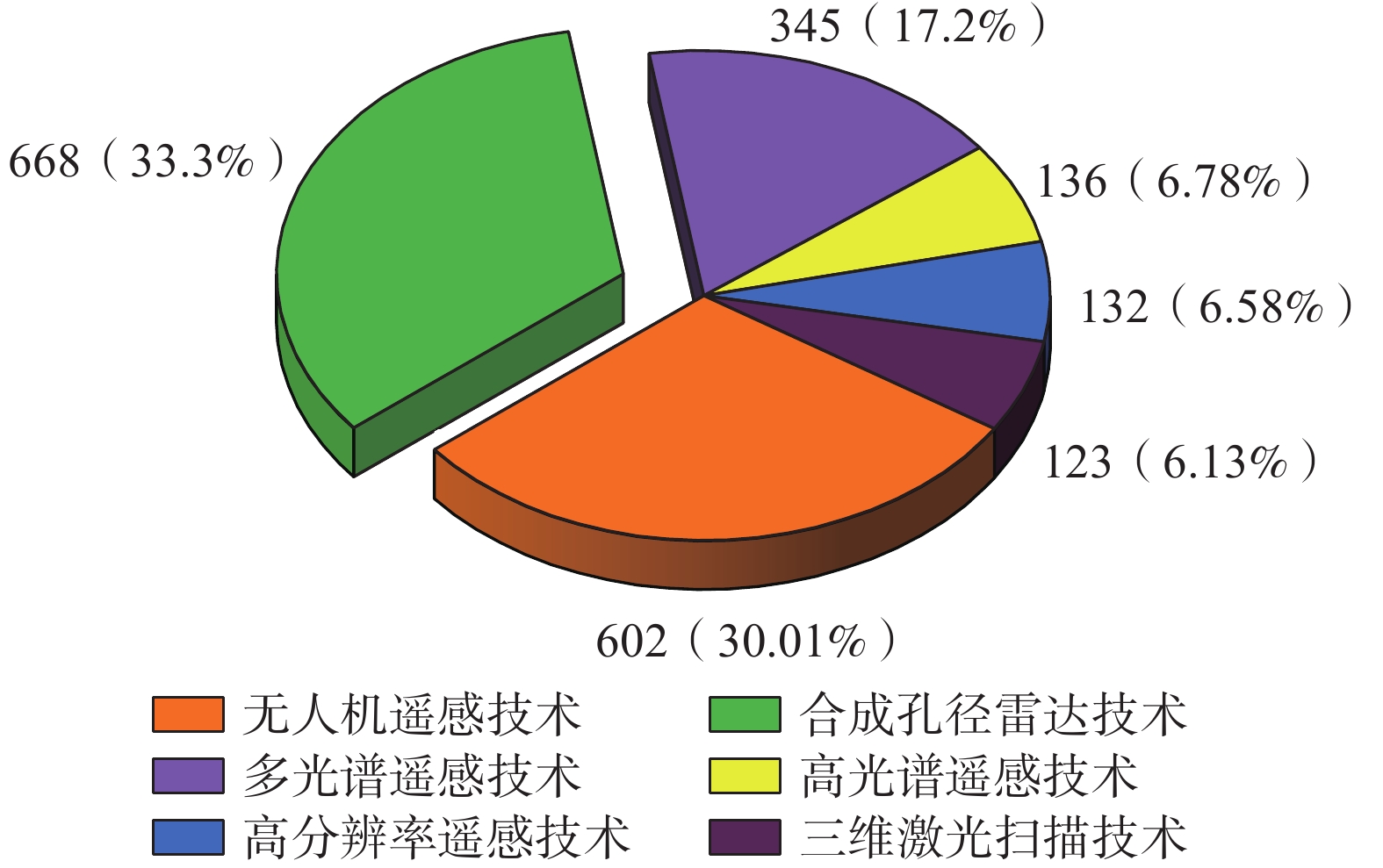
图 3 2003—2022年主要地质灾害遥感调查技术发文量分布
Figure 3. Distribution of research publications on major geological hazard remote sensing survey technologies from 2003 to 2022
![]()
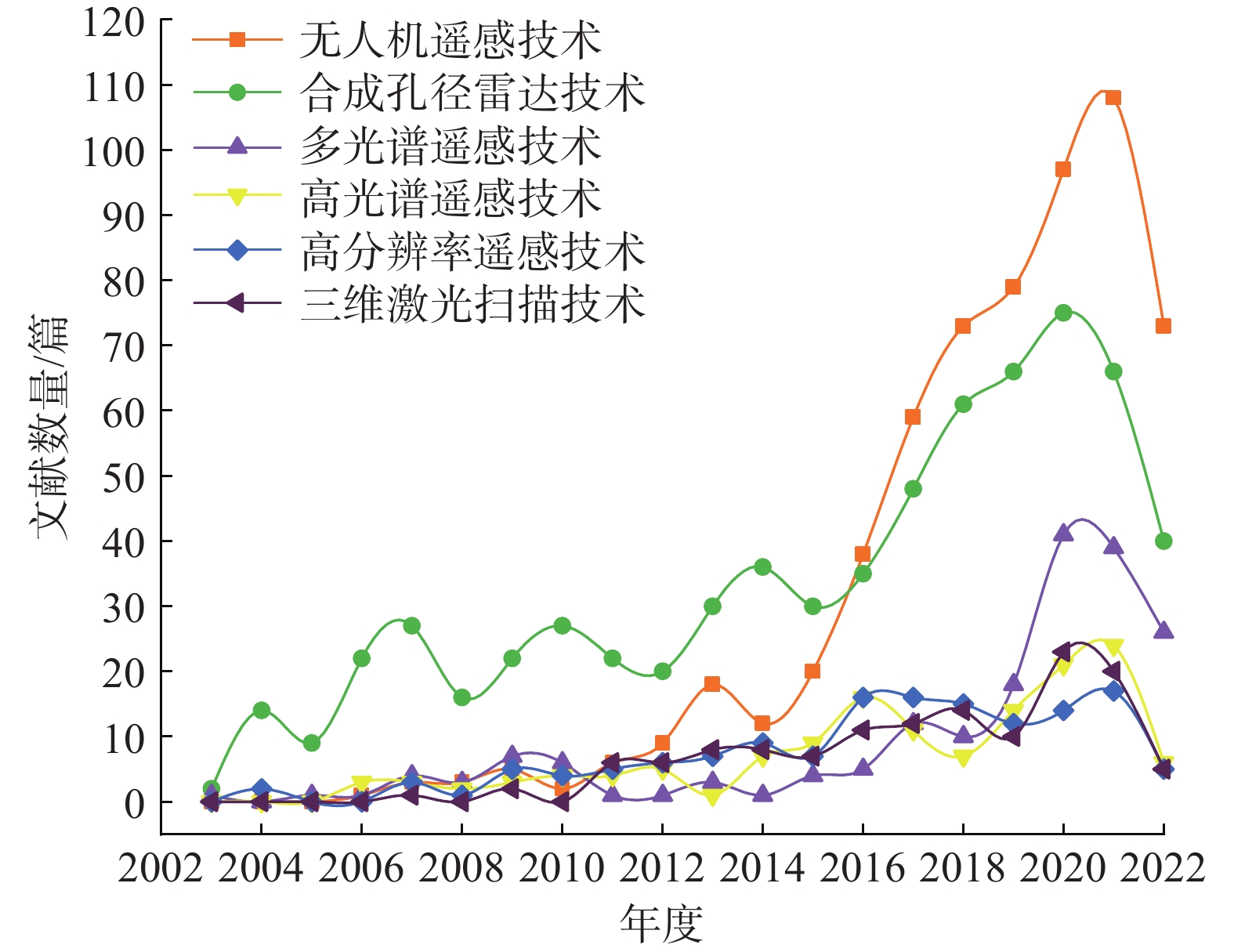
图 4 2003—2022年主要地质灾害遥感调查技术发文量逐年发展趋势
Figure 4. Annual development trends of research publications on major geological hazard remote sensing survey technologies from 2003 to 2022
![]()
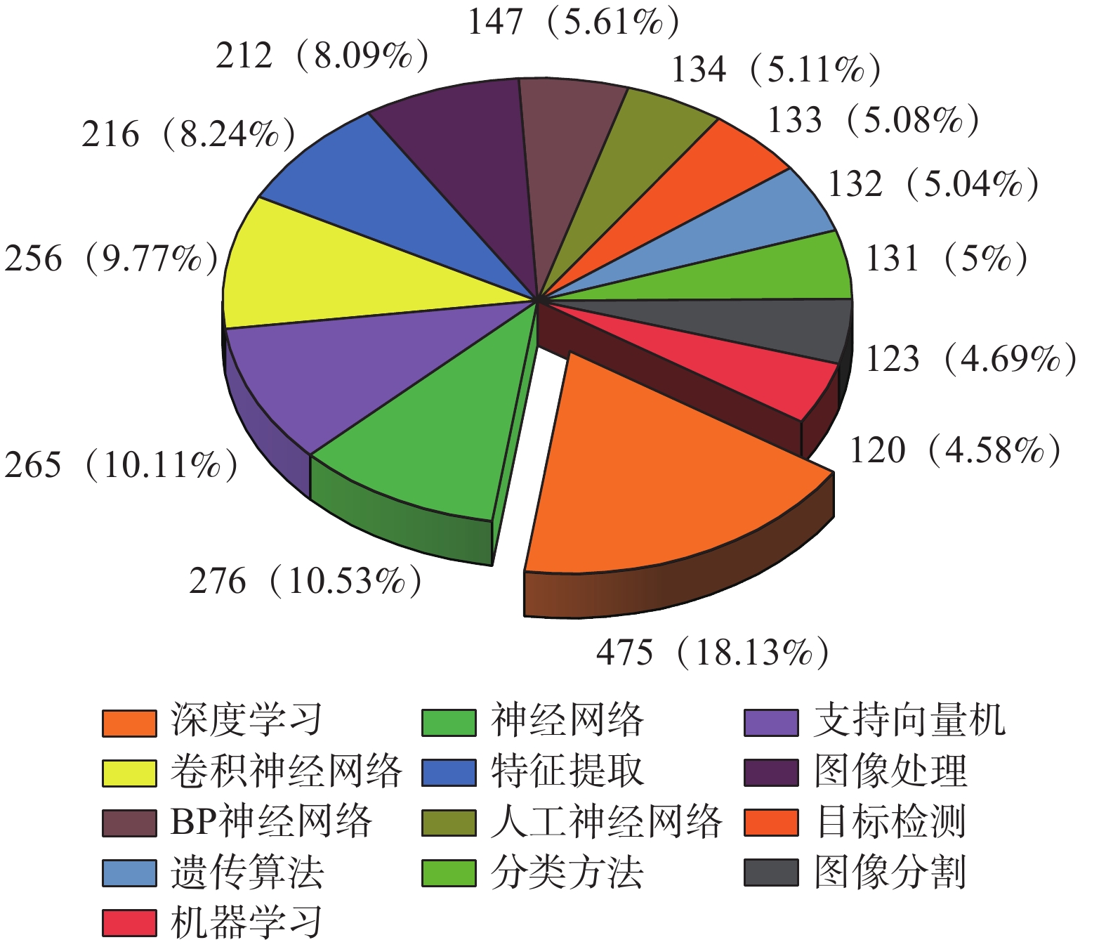
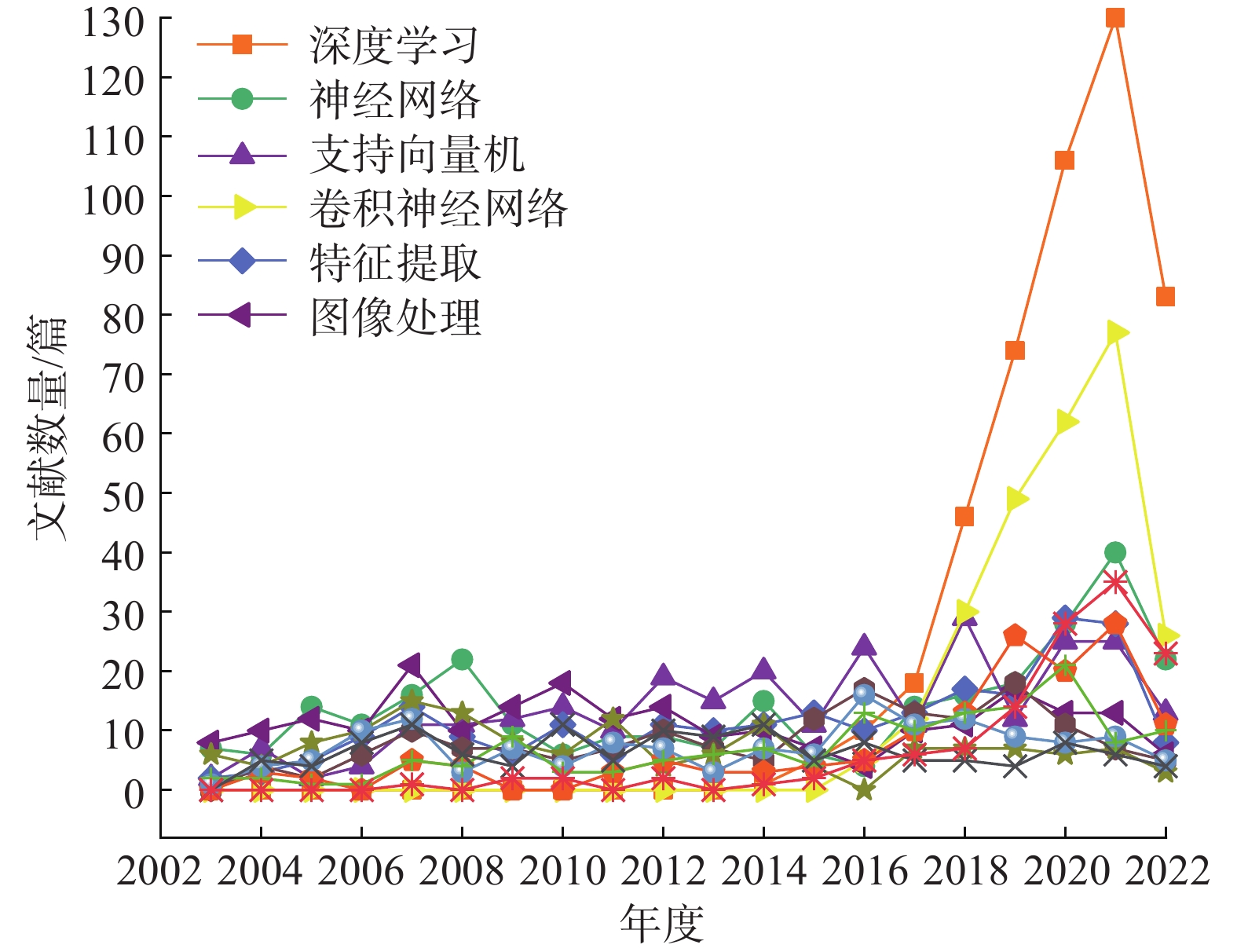
图 5 2003—2022年主要机器学习发文量分布
Figure 5. Distribution of research publications on major artificial intelligence algorithms from 2003 to 2022
![]()
图 6 2003—2022年主要机器学习发文量逐年发展趋势
Figure 6. Annual development trends of research publications on major machine learning from 2003 to 2022
![]()
图 7 2003—2022年无人机遥感技术与各种机器学习关键词关联度
Figure 7. Association between unmanned aerial vehicle remote sensing technology and various artificial intelligence algorithm keywords from 2003 to 2022
![]()
图 8 2003—2022年SAR技术与各种机器学习关键词关联度
Figure 8. Association between sar (synthetic aperture radar) technology and various artificial intelligence algorithm keywords from 2003 to 2022
![]()
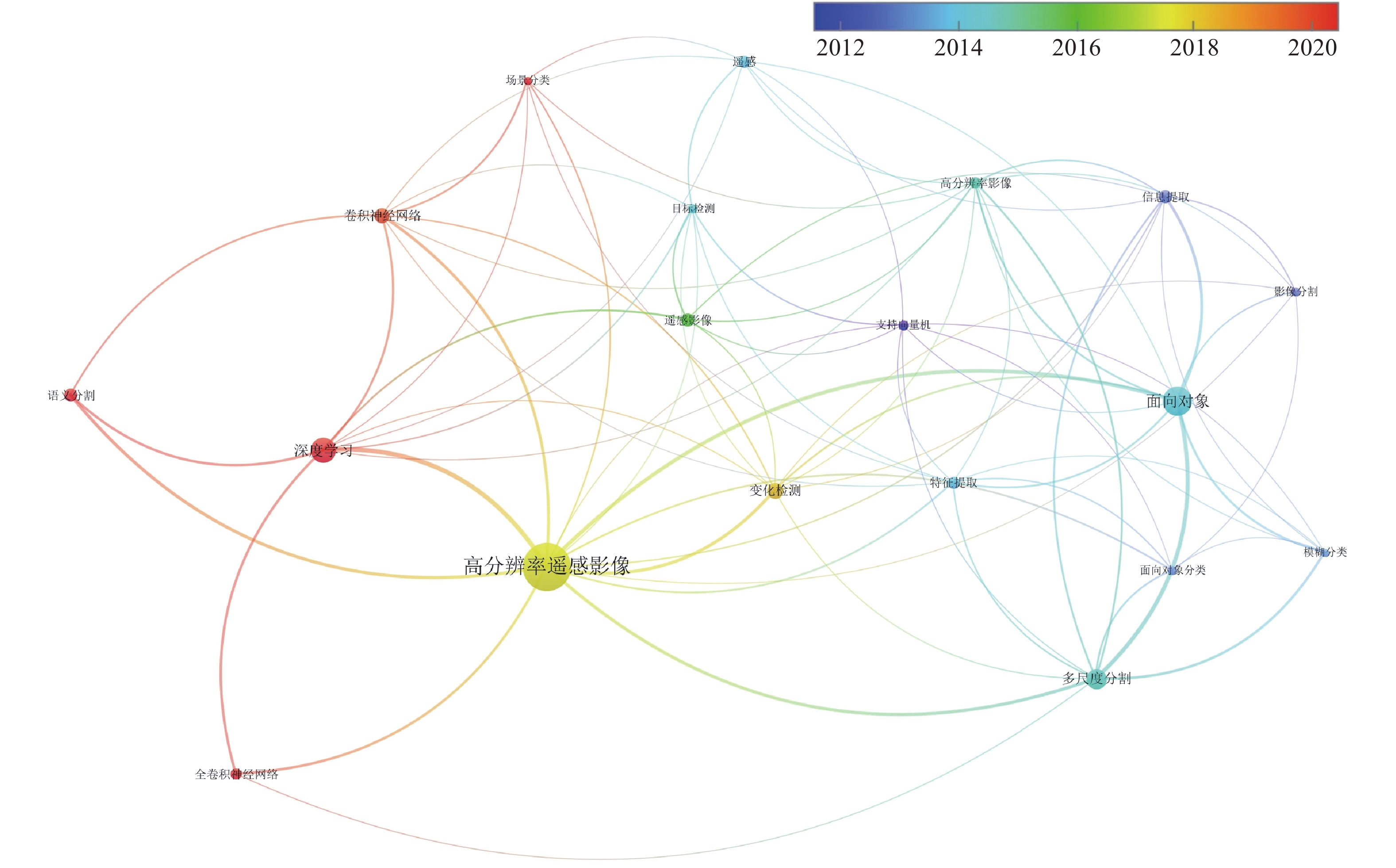
图 9 2003—2022年高分辨率遥感技术与各种机器学习关键词关联度
Figure 9. Association between high-resolution remote sensing technology and various artificial intelligence algorithm keywords from 2003 to 2022
-
[1] 万佳威,褚宏亮,李滨,等. 西藏嘉黎断裂带沿线高位链式地质灾害发育特征分析[J]. 中国地质灾害与防治学报,2021,32(3):51 − 60. [WAN Jiawei,CHU Hongliang,LI Bin,et al. Analysis on the development characteristics of high-level chain geological disasters along the Jiali fault zone in Tibet[J]. The Chinese Journal of Geological Hazard and Control,2021,32(3):51 − 60. (in Chinese with English abstract)] WAN Jiawei, CHU Hongliang, LI Bin, et al. Analysis on the development characteristics of high-level chain geological disasters along the Jiali fault zone in Tibet[J]. The Chinese Journal of Geological Hazard and Control, 2021, 32(3): 51 − 60. (in Chinese with English abstract)
[2] 张凯翔,张占荣,于宪煜. SBAS-InSAR和PS-InSAR技术在鲁西南某线性工程沿线地面沉降成因分析中的应用[J]. 中国地质灾害与防治学报,2022,33(4):65 − 76. [ZHANG Kaixiang,ZHANG Zhanrong,YU Xianyu. Application of SBAS-InSAR and PS-InSAR technologies in analysis of landslide subsidence along a linear infrastructure in Southwestern Shandong[J]. The Chinese Journal of Geological Hazard and Control,2022,33(4):65 − 76. (in Chinese with English abstract)] ZHANG Kaixiang, ZHANG Zhanrong, YU Xianyu. Application of SBAS-InSAR and PS-InSAR technologies in analysis of landslide subsidence along a linear infrastructure in Southwestern Shandong[J]. The Chinese Journal of Geological Hazard and Control, 2022, 33(4): 65 − 76. (in Chinese with English abstract)
[3] 赖积保,康旭东,鲁续坤,等. 新一代人工智能驱动的陆地观测卫星遥感应用技术综述[J]. 遥感学报,2022,26(8):1530 − 1546. [LAI Jibao,KANG Xudong,LU Xukun,et al. A review of land observation satellite remote sensing application technology with new generation artificial intelligence[J]. National Remote Sensing Bulletin,2022,26(8):1530 − 1546. (in Chinese with English abstract)] DOI: 10.11834/j.issn.1007-4619.2022.8.ygxb202208004 LAI Jibao, KANG Xudong, LU Xukun, et al. A review of land observation satellite remote sensing application technology with new generation artificial intelligence[J]. National Remote Sensing Bulletin, 2022, 26(8): 1530 − 1546. (in Chinese with English abstract) DOI: 10.11834/j.issn.1007-4619.2022.8.ygxb202208004
[4] 黄昕,李家艺. 人工智能-遥感大数据时代的《遥感图像智能解译》课程教学设计与思考[J]. 测绘地理信息,2022,47(增刊1):219 − 222. [HUANG Xin,LI Jiayi. Discussion on teaching design of intelligent interpretation of remote sensing images in the era of artificial intelligence and remote sensing big data[J]. Journal of Geomatics,2022,47(Sup 1):219 − 222. (in Chinese with English abstract)] HUANG Xin, LI Jiayi. Discussion on teaching design of intelligent interpretation of remote sensing images in the era of artificial intelligence and remote sensing big data[J]. Journal of Geomatics, 2022, 47(Sup 1): 219 − 222. (in Chinese with English abstract)
[5] 龚健雅,张觅,胡翔云,等. 智能遥感深度学习框架与模型设计[J]. 测绘学报,2022,51(4):475 − 487. [GONG Jianya,ZHANG Mi,HU Xiangyun,et al. The design of deep learning framework and model for intelligent remote sensing[J]. Acta Geodaetica et Cartographica Sinica,2022,51(4):475 − 487. (in Chinese with English abstract)] DOI: 10.11947/j.issn.1001-1595.2022.4.chxb202204002 GONG Jianya, ZHANG Mi, HU Xiangyun, et al. The design of deep learning framework and model for intelligent remote sensing[J]. Acta Geodaetica et Cartographica Sinica, 2022, 51(4): 475 − 487. (in Chinese with English abstract) DOI: 10.11947/j.issn.1001-1595.2022.4.chxb202204002
[6] 汉秋,王敬宇,赵理华. 基于人工智能的自然资源要素遥感解译的建设应用[J]. 中国测绘,2021(7):66 − 69. [HAN Qiu,WANG Jingyu,ZHAO Lihua. Construction and application of remote sensing interpretation of natural resources elements based on artificial intelligence[J]. China Surveying and Mapping,2021(7):66 − 69. (in Chinese with English abstract)] DOI: 10.3969/j.issn.1005-6831.2021.07.017 HAN Qiu, WANG Jingyu, ZHAO Lihua. Construction and application of remote sensing interpretation of natural resources elements based on artificial intelligence[J]. China Surveying and Mapping, 2021(7): 66 − 69. (in Chinese with English abstract) DOI: 10.3969/j.issn.1005-6831.2021.07.017
[7] 欧阳松. 地学知识嵌入的遥感影像深度语义分割方法研究[D]. 武汉:武汉大学,2021. [OUYANG Song. Research on depth semantic segmentation method of remote sensing image embedded with geoscience knowledge[D]. Wuhan:Wuhan University,2021. (in Chinese with English abstract)] OUYANG Song. Research on depth semantic segmentation method of remote sensing image embedded with geoscience knowledge[D]. Wuhan: Wuhan University, 2021. (in Chinese with English abstract)
[8] 人工智能正成为遥感大数据的“解译侠”[J]. 电子技术与软件工程,2019(15):12. [Artificial intelligence is becoming the “interpreter” of remote sensing big data[J]. Electronic Technology & Software Engineering,2019(15):12. (in Chinese)] Artificial intelligence is becoming the “interpreter” of remote sensing big data[J]. Electronic Technology & Software Engineering, 2019(15): 12. (in Chinese)
[9] 葛大庆. 地质灾害早期识别与监测预警中的综合遥感应用[J]. 城市与减灾,2018(6):53 − 60. [GE Daqing. Application of integrated remote sensing in early identification,monitoring and early warning of geological disasters[J]. City and Disaster Reduction,2018(6):53 − 60. (in Chinese with English abstract)] DOI: 10.3969/j.issn.1671-0495.2018.06.011 GE Daqing. Application of integrated remote sensing in early identification, monitoring and early warning of geological disasters[J]. City and Disaster Reduction, 2018(6): 53 − 60. (in Chinese with English abstract) DOI: 10.3969/j.issn.1671-0495.2018.06.011
[10] 许强. 对滑坡监测预警相关问题的认识与思考[J]. 工程地质学报,2020,28(2):360 − 374. [XU Qiang. Understanding the landslide monitoring and early warning:consideration to practical issues[J]. Journal of Engineering Geology,2020,28(2):360 − 374. (in Chinese with English abstract)] DOI: 10.13544/j.cnki.jeg.2020-025 XU Qiang. Understanding the landslide monitoring and early warning: consideration to practical issues[J]. Journal of Engineering Geology, 2020, 28(2): 360 − 374. (in Chinese with English abstract) DOI: 10.13544/j.cnki.jeg.2020-025
[11] 葛大庆,戴可人,郭兆成,等. 重大地质灾害隐患早期识别中综合遥感应用的思考与建议[J]. 武汉大学学报(信息科学版),2019,44(7):949 − 956. [GE Daqing,DAI Keren,GUO Zhaocheng,et al. Early identification of serious geological hazards with integrated remote sensing technologies:thoughts and recommendations[J]. Geomatics and Information Science of Wuhan University,2019,44(7):949 − 956. (in Chinese with English abstract)] GE Daqing, DAI Keren, GUO Zhaocheng, et al. Early identification of serious geological hazards with integrated remote sensing technologies: thoughts and recommendations[J]. Geomatics and Information Science of Wuhan University, 2019, 44(7): 949 − 956. (in Chinese with English abstract)
[12] 朱建军,杨泽发,李志伟. InSAR矿区地表三维形变监测与预计研究进展[J]. 测绘学报,2019,48(2):135 − 144. [ZHU Jianjun,YANG Zefa,LI Zhiwei. Recent progress in retrieving and predicting mining-induced 3D displace-ments using InSAR[J]. Acta Geodaetica et Cartographica Sinica,2019,48(2):135 − 144. (in Chinese with English abstract)] DOI: 10.11947/j.AGCS.2019.20180188 ZHU Jianjun, YANG Zefa, LI Zhiwei. Recent progress in retrieving and predicting mining-induced 3D displace-ments using InSAR[J]. Acta Geodaetica et Cartographica Sinica, 2019, 48(2): 135 − 144. (in Chinese with English abstract) DOI: 10.11947/j.AGCS.2019.20180188
[13] 郭庆华,胡天宇,刘瑾,等. 轻小型无人机遥感及其行业应用进展[J]. 地理科学进展,2021,40(9):1550 − 1569. [GUO Qinghua,HU Tianyu,LIU Jin,et al. Advances in light weight unmanned aerial vehicle remote sensing and major industrial applications[J]. Progress in Geography,2021,40(9):1550 − 1569. (in Chinese with English abstract)] DOI: 10.18306/dlkxjz.2021.09.010 GUO Qinghua, HU Tianyu, LIU Jin, et al. Advances in light weight unmanned aerial vehicle remote sensing and major industrial applications[J]. Progress in Geography, 2021, 40(9): 1550 − 1569. (in Chinese with English abstract) DOI: 10.18306/dlkxjz.2021.09.010
[14] 许强,郭晨,董秀军. 地质灾害航空遥感技术应用现状及展望[J]. 测绘学报,2022,51(10):2020 − 2033. [XU Qiang,GUO Chen,DONG Xiujun. Application status and prospect of aerial remote sensing technology for geohazards[J]. Acta Geodaetica et Cartographica Sinica,2022,51(10):2020 − 2033. (in Chinese with English abstract)] XU Qiang, GUO Chen, DONG Xiujun. Application status and prospect of aerial remote sensing technology for geohazards[J]. Acta Geodaetica et Cartographica Sinica, 2022, 51(10): 2020 − 2033. (in Chinese with English abstract)
[15] 王昆,杨鹏,吕文生,等. 无人机遥感在矿业领域应用现状及发展态势[J]. 工程科学学报,2020,42(9):1085 − 1095. [WANG Kun,YANG Peng,LYU Wensheng,et al. Current status and development trend of UAV remote sensing applications in the mining industry[J]. Chinese Journal of Engineering,2020,42(9):1085 − 1095. (in Chinese with English abstract)] WANG Kun, YANG Peng, LYU Wensheng, et al. Current status and development trend of UAV remote sensing applications in the mining industry[J]. Chinese Journal of Engineering, 2020, 42(9): 1085 − 1095. (in Chinese with English abstract)
[16] 汪美华,赵慧,倪天翔, 等. 近30年滑坡研究文献图谱可视化分析[J]. 中国地质灾害与防治学报,2023,34(4):75 − 85. [WANG Meihua, ZHAO Hui, NI Tianxiang, et al. Visualization analysis of research literature map on landslides in the past 30 years[J]. The Chinese Journal of Geological Hazard and Control,2023,34(4):75 − 85. (in Chinese with English abstract)] WANG Meihua, ZHAO Hui, NI Tianxiang, et al. Visualization analysis of research literature map on landslides in the past 30 years[J]. The Chinese Journal of Geological Hazard and Control, 2023, 34(4): 75 − 85. (in Chinese with English abstract)
[17] 董文,潘建平,阳振宇,等. 高分二号卫星数据在地质灾害调查中的应用——以重庆万州区为例[J]. 中国地质灾害与防治学报,2019,30(1):106 − 111. [DONG Wen,PAN Jianping,YANG Zhenyu,et al. Application of GF-2 satellite data in geological hazard survey:A case study in Wanzhou District of Chongqing City[J]. The Chinese Journal of Geological Hazard and Control,2019,30(1):106 − 111. (in Chinese with English abstract)] DOI: 10.16031/j.cnki.issn.1003-8035.2019.01.13 DONG Wen, PAN Jianping, YANG Zhenyu, et al. Application of GF-2 satellite data in geological hazard survey: A case study in Wanzhou District of Chongqing City[J]. The Chinese Journal of Geological Hazard and Control, 2019, 30(1): 106 − 111. (in Chinese with English abstract) DOI: 10.16031/j.cnki.issn.1003-8035.2019.01.13
[18] 张幼莹,余江宽,张丹丹,等. 国产卫星影像本底数据更新的实用方案——以地质灾害易发区遥感影像为例[J]. 国土资源遥感,2017,29(1):149 − 157. [ZHANG Youying,YU Jiangkuan,ZHANG Dandan,et al. Practical solution for background data update of domestic satellite images:A case study of remote sensing images of geological hazard prone areas[J]. Remote Sensing for Land & Resources,2017,29(1):149 − 157. (in Chinese with English abstract)] ZHANG Youying, YU Jiangkuan, ZHANG Dandan, et al. Practical solution for background data update of domestic satellite images: A case study of remote sensing images of geological hazard prone areas[J]. Remote Sensing for Land & Resources, 2017, 29(1): 149 − 157. (in Chinese with English abstract)
[19] 许强. 对地质灾害隐患早期识别相关问题的认识与思考[J]. 武汉大学学报(信息科学版),2020,45(11):1651 − 1659. [XU Qiang. Understanding and consideration of related issues in early identification of potential geohazards[J]. Geomatics and Information Science of Wuhan University,2020,45(11):1651 − 1659. (in Chinese with English abstract)] XU Qiang. Understanding and consideration of related issues in early identification of potential geohazards[J]. Geomatics and Information Science of Wuhan University, 2020, 45(11): 1651 − 1659. (in Chinese with English abstract)
[20] 许强,董秀军,李为乐. 基于天-空-地一体化的重大地质灾害隐患早期识别与监测预警[J]. 武汉大学学报(信息科学版),2019,44(7):957 − 966. [XU Qiang,DONG Xiujun,LI Weile. Integrated space-air-ground early detection,monitoring and warning system for potential catastrophic geohazards[J]. Geomatics and Information Science of Wuhan University,2019,44(7):957 − 966. (in Chinese with English abstract)] XU Qiang, DONG Xiujun, LI Weile. Integrated space-air-ground early detection, monitoring and warning system for potential catastrophic geohazards[J]. Geomatics and Information Science of Wuhan University, 2019, 44(7): 957 − 966. (in Chinese with English abstract)
[21] 段杰斌. 基于循环神经网络的太原西山山区滑坡预测研究[D]. 西安:西安科技大学,2020. [DUAN Jiebin. Study on landslide prediction in Xishan Mountain area of Taiyuan based on cyclic neural network[D]. Xi’an:Xi’an University of Science and Technology,2020. (in Chinese with English abstract)] DUAN Jiebin. Study on landslide prediction in Xishan Mountain area of Taiyuan based on cyclic neural network[D]. Xi’an: Xi’an University of Science and Technology, 2020. (in Chinese with English abstract)
[22] 孙启新. 面向卷积神经网络场景解译的地质灾害遥感影像样本库建设研究[D]. 成都:西南交通大学,2019. [SUN Qixin. Research on the construction of geological disaster remote sensing image sample database for convolutional neural network scene interpretation[D]. Chengdu:Southwest Jiaotong University,2019. (in Chinese with English abstract)] SUN Qixin. Research on the construction of geological disaster remote sensing image sample database for convolutional neural network scene interpretation[D]. Chengdu: Southwest Jiaotong University, 2019. (in Chinese with English abstract)
[23] 张茂省,贾俊,王毅,等. 基于机器学习(machine learning)的地质灾害防控体系建设[J]. 西北地质,2019,52(2):103 − 116. [ZHANG Maosheng,JIA Jun,WANGYi,et al. Construction of geological disaster prevention and control system base on machine learning[J]. Northwestern Geology,2019,52(2):103 − 116. (in Chinese with English abstract)] ZHANG Maosheng, JIA Jun, WANGYi, et al. Construction of geological disaster prevention and control system base on machine learning[J]. Northwestern Geology, 2019, 52(2): 103 − 116. (in Chinese with English abstract)
[24] 葛涛涛. 基于机器学习算法的日喀则地区泥石流易发性研究[D]. 南京:南京信息工程大学,2019. [GE Taotao. Study on the susceptibility of debris flow in Xigaze area based on machine learning algorithm[D]. Nanjing:Nanjing University of Information Science & Technology,2019. (in Chinese with English abstract)] GE Taotao. Study on the susceptibility of debris flow in Xigaze area based on machine learning algorithm[D]. Nanjing: Nanjing University of Information Science & Technology, 2019. (in Chinese with English abstract)
[25] 梁柱. 机器学习在浅层滑坡敏感性评价中的综合应用与研究[D]. 长春:吉林大学,2021. [LIANG Zhu. Comprehensive application and research of machine learning in sensitivity evaluation of shallow landslide[D]. Changchun:Jilin University,2021. (in Chinese with English abstract)] LIANG Zhu. Comprehensive application and research of machine learning in sensitivity evaluation of shallow landslide[D]. Changchun: Jilin University, 2021. (in Chinese with English abstract)
[26] 程刚,王振雪,李刚强,等. 我国滑坡监测文献计量研究的可视化分析[J]. 中国安全科学学报,2022,32(7):172 − 179. [CHENG Gang,WANG Zhenxue,LI Gangqiang,et al. Visual analysis of bibliometric research on landslide monitoring in China[J]. China Safety Science Journal,2022,32(7):172 − 179. (in Chinese with English abstract)] DOI: 10.16265/j.cnki.issn1003-3033.2022.07.2766 CHENG Gang, WANG Zhenxue, LI Gangqiang, et al. Visual analysis of bibliometric research on landslide monitoring in China[J]. China Safety Science Journal, 2022, 32(7): 172 − 179. (in Chinese with English abstract) DOI: 10.16265/j.cnki.issn1003-3033.2022.07.2766
[27] 白青林,刘烜良,张军华,等. 基于CV-XGBoost的水下分流河道砂体厚度预测及应用[J]. 吉林大学学报(地球科学版),2023,53(5):1602 − 1610. [BAI Qinglin, LIU Xuanliang, ZHANG Junhua, et al. Sand body thickness prediction of underwater distributary channel based on CV-XGBoost method[J]. Journal of Jilin University (Earth Science Edition),2023,53(5):1602 − 1610. (in Chinese with English abstract)] BAI Qinglin, LIU Xuanliang, ZHANG Junhua, et al. Sand body thickness prediction of underwater distributary channel based on CV-XGBoost method[J]. Journal of Jilin University (Earth Science Edition), 2023, 53(5): 1602 − 1610. (in Chinese with English abstract)
[28] 欧阳渊,刘洪,李光明,等. 基于随机森林算法的找矿预测——以冈底斯成矿带西段斑岩——浅成低温热液型铜多金属矿为例[J]. 中国地质,2023,50(2):303 − 330. [OUYANG Yuan, LIU Hong, LI Guangming, et al. Mineral search prediction based on Random Forest algorithm:A case study on porphyry-epithermal copper polymetallic deposits in the western Gangdise meatallogenic belt[J]. Geology in China,2023,50(2):303 − 330. (in Chinese with English abstract)] OUYANG Yuan, LIU Hong, LI Guangming, et al. Mineral search prediction based on Random Forest algorithm: A case study on porphyry-epithermal copper polymetallic deposits in the western Gangdise meatallogenic belt[J]. Geology in China, 2023, 50(2): 303 − 330. (in Chinese with English abstract)
-
期刊类型引用(1)
1. 宋竹兵,高鹏,陈潇,赵云海,梁彦龙. 左权铁尾矿在高等级重载公路基层中应用研究. 公路工程. 2023(01): 79-85 .  百度学术
百度学术
其他类型引用(2)
 下载:
下载:


计量
- 文章访问数: 408
- HTML全文浏览量: 118
- PDF下载量: 197
- 被引次数: 3
 邮件订阅
邮件订阅 RSS
RSS