
Landslide geological hazard assessment based on the I-CF model of Dege County in Sichuan Province
-
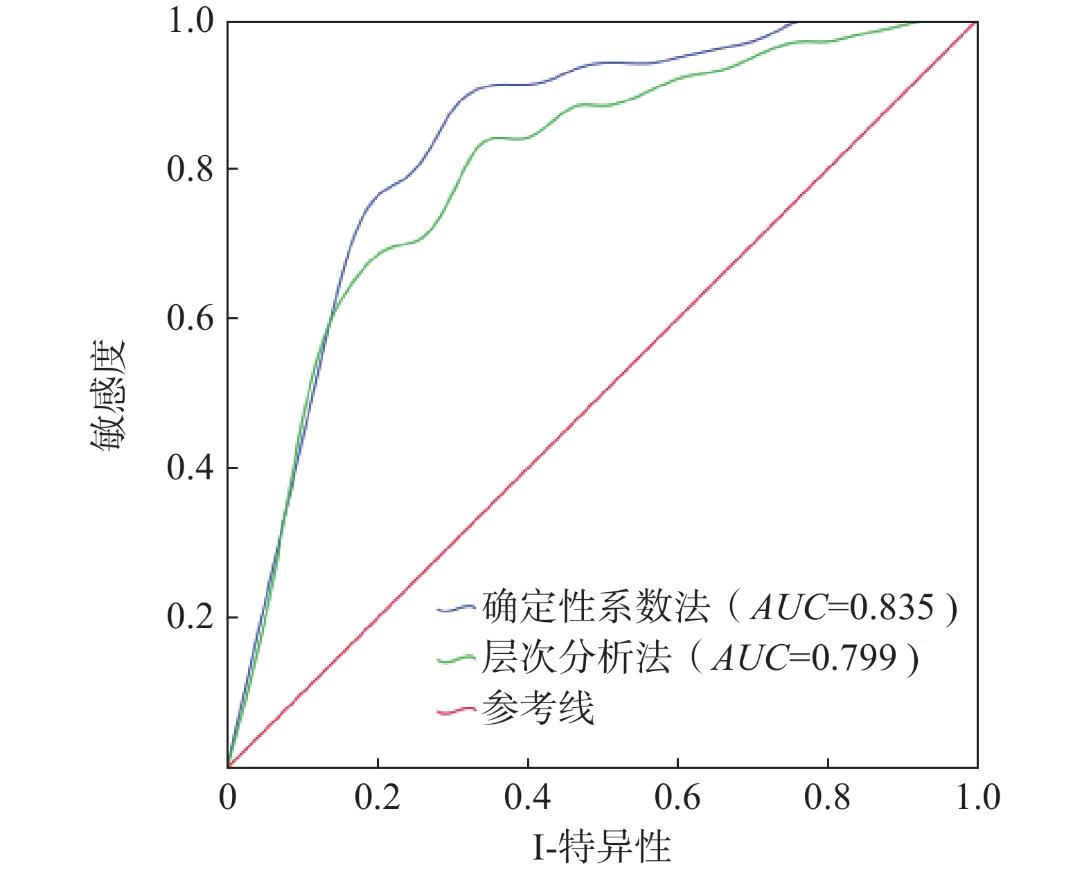
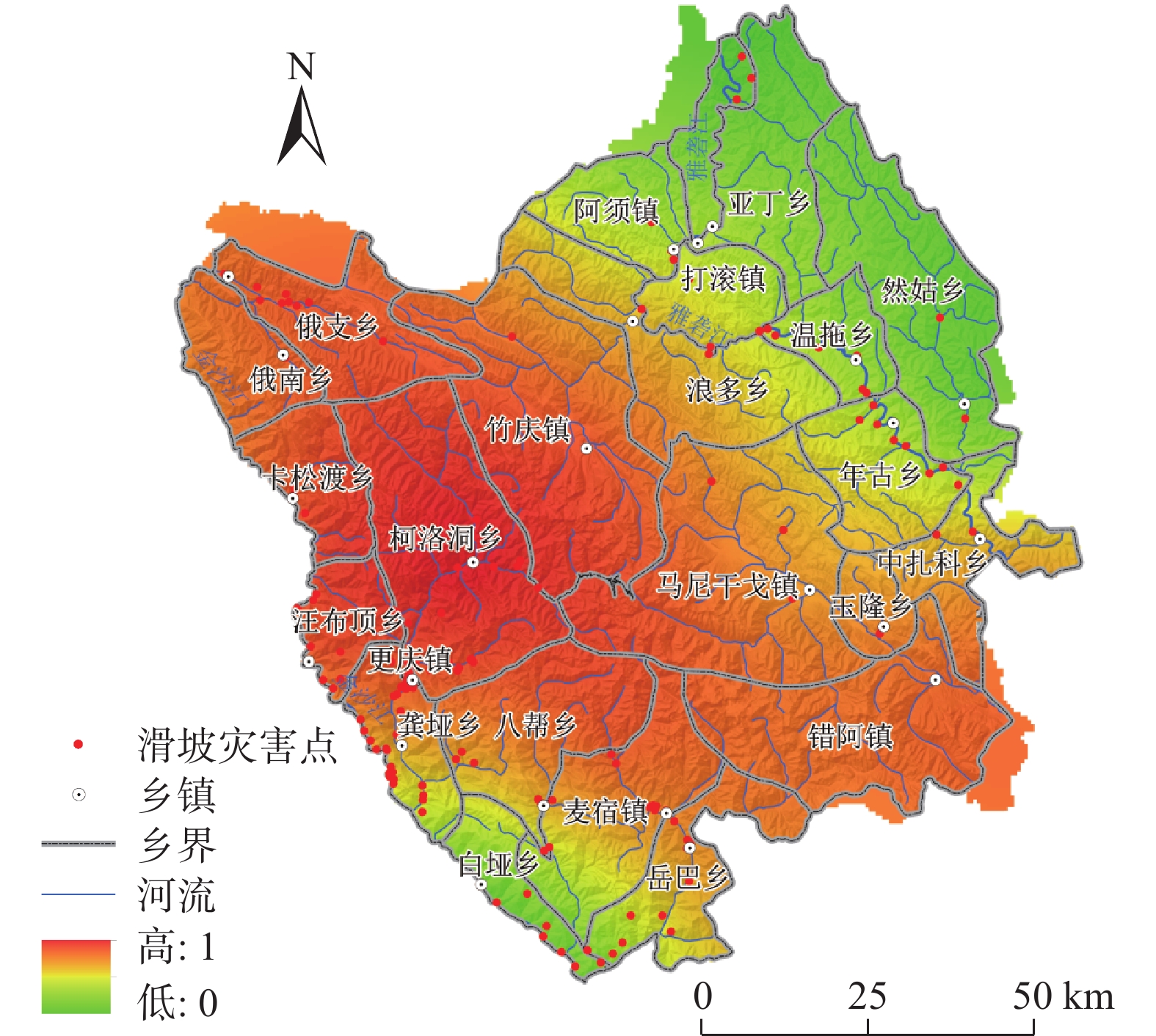
摘要: 文章以德格县为研究区,以7 m DEM进行地形分析处理,并结合相关调查数据建立了德格县滑坡灾害数据库,通过选取的地震峰值加速度、断裂带、水系、坡度、坡向、高程、岩性等7个指标,在GIS技术支持下,利用信息量模型(I)、层次分析法模型(AHP)、确定性系数模型(CF)相互耦合对研究区灾害敏感性评价,再分析得到活动频率因素对研究区全县域进行危险性评价,将得到的结果分成4个区域,分别为高危险区、较高危险区、中危险区、低危险区,其中高、较高危险区占总面积2.23%。其中,滑坡灾害占总灾害的42%。评价结果与实际调查结果符合程度较高,能够为该地域未进行实地调查的地方进行相关滑坡灾害的预测预报,并对安全防治提供技术支持,亦可以为其他地区滑坡灾害危险性评价提供理论指导和技术参考。Abstract: This study focuses on Dege County as the research area, and carries out terrain analysis and processing with 7m DEM. A landslide hazard database for Dege County is establishing using relevant survey data. With the support of GIS technology, this research employs the information quantity model (I), analytic hierarchy process model (AHP), and deterministic coefficient model (CF) coupling to evaluate the hazard sensitivity within the study area based on seven selected indicators: mic peak acceleration, fault zone, water system, slope, slope direction, elevation, and lithology. Subsequently, an assessment of hazard is conducted for the entire county domain by considering factors related to landslide activity frequency. The results are categorized into four zones: high risk, relatively high risk, moderate risk, and low risk. The high and relatively high-risk zones collectively cover 2.23% of the total area, with landslides accounting for 42% of the overall hazards. The evaluation results align well with the actual survey findings, providing technical support for predicting, forecasting, and implementing safety measures against landslide disasters in areas that without field investigation. Furthermore, it can serve as a theoretical guide and technical reference for the risk assessment of landslide hazard in other regions.
-
Keywords:
- landslide /
- GIS /
- hazard assessment /
- certainty factor method /
- Dege County
-
0. 引 言
每年由于滑坡形成的地质灾害都会给我国造成巨大的人员伤亡和财产损失。根据最新公布的《中国统计年鉴2024》统计,近5年共发生地质灾害
28109 起,其中滑坡地质灾害16290 起,占总地质灾害数量的57.67%[1],是最常见的灾害类型之一。因此,对滑坡地质灾害进行早期防控,对于减少人员伤亡和经济损失都具有十分重要的实际意义。其中,变形速率作为对滑坡地质灾害预警和防控最主要的依据之一,其预测的准确度和时效性对于滑坡地质灾害的预测和防控起着关键作用。然而,滑坡地质灾害特别是突发型滑坡在其变形过程中,可能会发生与历史变形趋势完全不符的变形趋势[2],导致现有方法在预测此类问题时产生困难。随着近年来人工智能技术的飞速发展,在线监测与深度学习相结合的超前预测逐渐成为滑坡地质灾害防控研究的热点[3 − 5]。其中,长短时记忆(long short term memory network,LSTM)神经网络由于其在处理时序数据上的优势而得到广泛关注[6 − 7]。如李丽敏等[8]将滑坡累计位移分解为趋势项与波动项,并用多项式拟合预测趋势项、LSTM网络预测波动项;张明岳等[9]预测对比了循环神经网络(recurrent neural network,RNN)和LSTM2种模型在滑坡位移预测时的精度;LI等[10]采用自回归、LSTM和支持向量机(support vector machines,SVM)建立了综合模型并分析了各模型的权重;唐宇峰等[11]采用了一种动态残差修正的LSTM进行了滑坡位移预测。然而,传统LSTM网络难以同时提取从后向前的信息,使其应用受到了一定的限制。相比于传统LSTM网络,Tengtrairat等[12]提出了一种双向长短期记忆(bi-directional long short term memory network,BiLSTM)神经网络算法,该方法采用双向重叠计算的方法,比单向LSTM可以更好地捕捉双向时序特征,因此具有更好的应用前景[13]。在滑坡领域,Cui等[14]提出一种基于语义门(semantic gate,SG)和双时长短期记忆网络(SG-BiLSTM)的方法,并识别了滑坡体图像;Wang等[15]通过BiLSTM-RNN及卷积神经网络(convolutional neural network,CNN)结合LSTM的方法,生成了基于人工智能的香港滑坡敏感性地图。Lin等[16]采用GRA-MIC融合相关计算方法选取了影响滑坡位移的因素,最后采用CNN-BiLSTM模型进行了预测。综上,BiLSTM方法在滑坡领域内已经取得许多成果。然而,对于突发型滑坡灾害,由于其在加速变形过程中的变形速率发展历程可能与历史变形速率历程完全不符,导致了现有方法在预测此类问题时存在精度及效率不足的困难。因此,建立一种动态预测且深层优化的多层耦合算法,在提高预测准确率的同时保证较快的响应速度,对于准确地进行突发型滑坡预警及增加预警后的应急响应时间是具有十分重要的实际意义的。
鉴于此,本文提出一种基于动态串联PSO- BiLSTM的滑坡变形速率预测方法,首先,通过集合经验模态分解(EEMD)将变形速率序列进行分解,得到周期项及趋势项变形速率序列;其次,设置PSO启动阈值,并分别通过多项式拟合及周期项PSO-BiLSTM预测网络,得到趋势项及周期项变形速率预测值,将预测值分别加入趋势项变形速率序列及周期项变形速率序列;再次,以趋势项变形速率序列、周期项变形速率序列及残差变形速率序列为输入,建立总PSO-BiLSTM预测网络,得到总预测变形速率,最后,由总预测变形速率和监测变形速率,相减得到下一循环计算所需的残差变形速率。通过以上方式,提高对变形速率预测的准确率及滑坡预警的响应速度,为增加滑坡预警时间提供一种新的思路。
1. PSO-BiLSTM算法理论基础
1.1 LSTM算法理论基础
LSTM神经网络是对RNN的改进算法,其工作原理见图1[17]。LSTM算法在RNN的基础上引入了单元状态c以及“门”的概念,解决了在RNN中存在的梯度消失和爆炸问题。
LSTM神经网络的基本单元称为细胞,由遗忘门、输入门及输出门构成。其中,遗忘门决定上一时刻的状态St−1保留至当前时刻的信息,其通过一个取值为0~1范围的Sigmoid函数,将输入xt与上一时刻的输出ht−1相联系来决定遗忘的信息,Sigmoid函数取0表示全部遗忘,取1代表全部记忆;输入门的作用是控制当前输入xt保存到状态单元St中的记忆量,其主要结构算法为:
(1) (2) (3) (4) (5) (6) 式中:
1.2 BiLSTM算法理论基础
BiLSTM网络是在LSTM网络基础上发展起来的,其可在不增加数据量的前提下学习序列数据和时间步长之间的双向依赖关系[12]。BiLSTM和单向LSTM最大的区别在于,前者可以同时保存过去和未来的信息,而后者只保存过去的信息,如图2所示。
1.3 PSO-BiLSTM算法
PSO常用来求解最优化问题,其基本思路是将待求解问题的解描述为粒子,每个粒子在N维解空间中可以不断寻求,其粒子极值
式中:
基于以上理论,基于PSO优化的BiLSTM网络训练流程如图3所示。
2. 动态串联PSO-BiLSTM算法
2.1 动态串联PSO-BiLSTM算法基本原理
滑坡体在随着时间的演变过程中,其滑坡变形速率趋势会呈现出“稳定型”、“渐变型”、“突发型”等不同的变化趋势。对于突发型滑坡,其从变形速率突变到产生滑坡的时间非常短(图4),现有方法在解决突变型滑坡位移预测时存在明显的精度不足、效率低下等困难。
(1)传统BiLSTM网络仅通过已有监测数据一次性建立和验证网络,并将该网络作为后续预测的依据,即“静态网络”。这种网络训练完成后不再更新,当变形速率发展趋势与前期变形速率趋势发生较大变化时,难以适应新趋势的发展,无法对变形速率进行有效预测。
(2)“动态网络”,即在每一次得到新的监测数据后对网络进行更新,可使网络具备更新后的变形速率信息,相比于静态网络可以显著提高预测精度。然而,一方面,动态BiLSTM网络预测的准确率与经验设定的网络参数有关,参数不当会严重影响其预测精度;另一方面,在变形速率产生突变时,其突变后的数据量少、突变速率变化快,动态网络的方法在预测时仍存在严重的滞后性。
(3)PSO优化可以对BiLSTM参数进行寻优从而提高准确率,但会大大增加计算成本,导致过长的预测时间而不利于工程的实际应用。
基于以上现状,本文建立了一种基于动态串联PSO-BiLSTM的滑坡变形速率预测方法。首先,设置每一次要分析的变形速率数据量N,通过“动态滑窗”方式截取待分析数据(“动态滑窗”指每获取最新一轮时序数据,将序列中最早的一轮时序数据去除,从而保持总数据量始终不变,达到减小待分析数据量和历史数据的影响的目的),并通过集合经验模态分解(EEMD)将变形速率序列进行分解,得到周期项及趋势项变形速率序列;其次,分别通过多项式拟合及周期项PSO-BiLSTM预测网络,得到趋势项及周期项变形速率预测值,并将预测值分别加入趋势项变形速率序列及周期项变形速率序列;再次,以趋势项变形速率序列、周期项变形速率序列及残差变形速率序列为输入,建立总PSO-BiLSTM预测网络,得到总预测变形速率;最后,由总预测变形速率和监测变形速率,相减得到下一循环建立总PSO-BiLSTM所需的残差变形速率。需要指出的是:(1)为提升预测效率,为PSO-BiLSTM网络仅当某一次预测的周期项残差率
![]() 图 5 动态串联PSO-BiLSTM算法预测流程Figure 5. Dynamic serial PSO-BiLSTM algorithm prediction process
图 5 动态串联PSO-BiLSTM算法预测流程Figure 5. Dynamic serial PSO-BiLSTM algorithm prediction process通过以上方式,在动态训练网络的基础上,考虑了不同历史时刻条件下动态网络速率预测的误差,实现了不同动态网络之间的学习,且仅当预测误差过大时才启动PSO优化,因此可在提高预测准确率的前提下保证较高的计算效率。
2.2 模型性能指标
为全面评价该滑坡变形速率预测模型精度,采用平均绝对误差(mean absolute error,MAE)、绝对百分比误差(mean absolute percentage error,MAPE)、均方根误差(root mean square error,RMSE)及拟合优度R2来作为模型性能指标,如下[20]:
(7) (8) (9) (10) 式中:
3. 工程实例
3.1 滑坡变形速率实测及预处理
以四川省某滑坡体实测变形速率为例。自2020年3月14日—9月17日间对该案例进行了地表裂缝监测及降雨量监测(图6),其中每小时一组数据,共得到了
11776 组滑坡变形速率监测数据。![]() 图 6 滑坡隐患点监测预警设备Figure 6. Landslide hazard point monitoring and early warning equipment
图 6 滑坡隐患点监测预警设备Figure 6. Landslide hazard point monitoring and early warning equipment该滑坡体在前期监测中变形一直相对稳定,自9月13日12时起,该滑坡隐患点在连日降雨影响下,其变形速率有明显突变迹象。如图7所示为9月13日前500 h内变形速率变化情况。
由图7所示, 该滑坡体在前期一直处于稳定状态,仅在突变前极短时间内变形速率发生了突变。由于本文的研究目的主要是针对变形速率产生突变情况下的预测研究,稳定期的变形速率对文章研究意义不大。因此仅选取了2020年9月12日17时—14日6时间的50 h为例进行探讨分析。
在实际工程中,存在变形速率的发展不是单向放大过程的情况,而是在某些时刻内会存在阶梯性的变化,这给变形速率的预测带来了困难。在本文中,采用“相邻极大值”方法来对数据进行预处理,即每一个时刻t的变形速率
从图8可以看出,该滑坡体的变形速率在20 h之后呈快速增加的趋势,其变化形态与历史趋势有着较大的差异,即产生了“突变”。
3.2 模型建立与参数选取
为验证本文方法的优势,分别采用动态BiLSTM网络(类型Ι)、动态PSO-BiLSTM网络(类型Ⅱ)、文中提出的动态串联PSO-BiLSTM网络在PSO启动残差率C=0(类型Ⅲ)和C=0.1(类型IV)4种情况进行预测分析。每类BiLSTM网络的输出均为一维。其中,动态BiLSTM的BiLSTM层节点数选取为50,正则化系数为0,初始学习率为0.2;PSO优化的参数为BiLSTM层节点数、初始学习率和正则化系数;PSO启动残差率C取0.1,动态滑窗截取数据为30,预测数据量为20。
3.3 预测结果及指标评价
4种类型算法均进行了3次预测,取计算结果的平均值。图9为4种方法变形速率预测结果与实测结果20轮预测对比。
![]() 图 9 20 h变形速率预测结果对比Figure 9. Comparison of deformation rate prediction results for 20 h
图 9 20 h变形速率预测结果对比Figure 9. Comparison of deformation rate prediction results for 20 h其中,为获取总PSO-BiLSTM网络所需的残差变形速率,在前10个预测循环中仅采用周期项PSO-BiLSTM网络进行预测,而最后10项采用动态串联PSO-BiLSTM网络进行预测。因此,以下仅选择最后10次数据进行对比分析,如图10所示。
![]() 图 10 10 h变形速率预测结果对比Figure 10. Comparison of deformation rate prediction results for 10 h
图 10 10 h变形速率预测结果对比Figure 10. Comparison of deformation rate prediction results for 10 h为进一步对比预测结果,采用MAE、MAPE、RMSE及R2共4种评价指标评价位移预测结果,表1为各模型位移预测结果的评价结果。
表 1 预测结果评价Table 1. Evaluation of prediction results预测
类型位移评价指标 计算时间/s MAE MAPE/% RMSE R2 类型Ⅰ 0.43 8.45 0.70 0.96 24.89 类型Ⅱ 0.36 7.07 0.61 0.97 294.50 类型Ⅲ 0.30 5.82 0.51 0.98 1861.87 类型Ⅳ 0.28 5.41 0.57 0.98 380.22 其中,MAE为绝对误差;MAPE为预测值与实测值的平均偏离程度,其越接近0表示效果越好;RMSE为预测值与真实值之间的偏差,越接近0表示预测值与真实值越吻合;R2越接近1说明预测越准确。
从图10及表1可以看出:(1)动态BiLSTM网络(类型Ⅰ)的绝对误差和平均偏离程度、偏差均为最大,且拟合优度R2最小,说明此时类型Ⅰ在四种类型中效果最差,但由于未采用PSO优化算法,此时拥有最佳的计算效率;(2)加入PSO算法后(类型Ⅱ),其MAE、MAPE和RMSE值相比类型Ⅰ均有明显的下降,且拟合优度上升,说明PSO优化算法对预测结果有明显的提升;(3)当加入串联算法后(类型Ⅲ和类型Ⅳ),其MAE、MAPE和RMSE值进一步下降,而拟合优度进一步提升,说明串联算法对预测精度有进一步提升;(4)类型Ⅲ与类型Ⅳ的各评价指标差距较小且各有优劣,但类型Ⅳ相比与类型Ⅲ计算效率大大提升,这对于滑坡变形速率的快速预测具有重要的实用价值。
4. 结论
(1)传统动态BiLSTM算法在进行滑坡变形速率预测时具有较高的计算效率,但在面临滑坡变形速率快速变化的情况时预测精度偏低;而相对于传统动态BiLSTM算法,PSO-BiLSTM优化算法对突发型滑坡变形速率预测结果有明显的提升。
(2)动态串联PSO-BiLSTM算法可以有效地提高突发型滑坡变形速率的预测准确率,但由于PSO优化计算时间过长,不利于工程应用;加入PSO启动机制后,其MAE、MAPE、RMSE、R2分别为0.28、5.41%、0.57、0.98,计算时间为380.22 s,在具有较高的精度的同时保证了计算效率,对于滑坡预测的快速响应、提高工程实用价值都有重要的意义。
-
表 1 地质灾害隐患点分布表
Table 1 Distribution table of geological hazards hidden danger points
序号 乡镇 滑坡/处 崩塌/处 泥石流/处 合计 面积/
km2每百平方公里
灾害数/处1 阿须镇 5 1 6 12 365.19 3.29 2 八帮乡 8 1 4 13 562.71 2.31 3 白垭乡 8 6 4 18 200.69 8.97 4 错阿镇 0 0 2 2 498.33 0.40 5 打滚镇 3 3 4 10 461.77 2.17 6 俄南乡 3 0 6 9 299.07 3.01 7 俄支乡 8 0 16 24 439.17 5.46 8 更庆镇 58 13 14 85 427.51 19.88 9 龚垭乡 10 9 2 21 267.66 7.85 10 卡松渡乡 4 1 7 12 299.67 4.00 11 柯洛洞乡 8 2 5 15 963.76 1.56 12 浪多乡 3 0 4 7 619.74 1.13 13 马尼干戈镇 3 0 2 5 1075.43 0.46 14 麦宿镇 11 1 16 28 584.16 4.79 15 年古乡 10 0 3 13 397.21 3.27 16 然姑乡 3 0 1 4 481.87 0.83 17 汪布顶乡 25 21 4 50 226.63 22.06 18 温拖乡 7 0 12 19 274.14 6.93 19 亚丁乡 0 1 6 7 607.54 1.15 20 玉隆乡 2 0 3 5 202.83 2.47 21 岳巴乡 11 1 1 13 605.36 2.15 22 中扎科乡 4 0 11 15 447.74 3.35 23 竹庆镇 1 0 0 1 1131.09 0.09  下载: 导出CSV
表 2 使用数据详情表
Table 2 Data utilization details table
数据名称 数据精度(比例尺) 高分一号(GF1)高精度遥感影像 0.5 m 德格县DEM 7 m 德格县地形数据图 1∶50000 德格县地质数据图 1∶10 000 甘孜州年均降雨量数据 − 地震峰值加速度分布图 −
下载: 导出CSV
表 3 指标分级敏感性量化值
Table 3 Quantitative sensitivity values for indicator classification
指标 指标分级 灾害点个数 分区面积/km2 信息量 信息量归一化 地震峰值加速度/g 0.10 6 1131.6443 −1.317042484 0 0.15 30 1004.5774 −0.395084795 0.592148498 0.20 207 1997.8012 0.239927923 1 0.30 12 7304.9769 −0.743000070 0.368691923 地震断裂带缓冲区/m [0,5000) 52 3625.0082 −0.440847835 0 [5000,10000) 64 2940.5943 −0.023963605 0.34370709 [10000,15000) 87 1803.2948 0.772057694 1 [15000,56037) 52 3070.1025 −0.274702222 0.136981495 水系缓冲区/m [0,300) 170 1299.6380 1.76947768 1 [300,600) 27 1285.4982 −0.059544488 0.41368016 [600,900) 14 1239.9860 −0.680277809 0.214695004 [900,6924) 44 7613.8776 −1.35001793 0 坡度/(°) [0,14) 69 5075.3157 −0.494517212 0 [14,25) 92 3495.4392 0.166094562 0.551272903 [25,35) 56 2024.9770 0.215558335 0.592549851 [35,90) 38 843.2679 0.703821706 1 坡向 阴坡 67 2730.6483 0.095918567 0.892332366 半阴坡 50 2961.6391 −0.277954847 0 阳坡 63 2824.8389 0.000448382 0.664471457 半阳坡 75 2921.8690 0.141029635 1 高程/m [2980,3800) 59 1304.6405 0.707374888 1 [3800,4200) 67 3609.7618 −0.183184166 0.245339931 [4200,4600) 94 4005.7085 0.051339327 0.444075225 [4600,6 168) 35 2518.8890 −0.472704846 0 岩性 坚硬岩 31 2728.6819 −0.674066445 0.150627096 较硬岩 24 2558.4692 −0.865590279 0 较软岩 190 5679.5360 0.405919554 1 松散岩 10 472.3128 −0.051536121 0.640226396
下载: 导出CSV
表 4 判断矩阵及权重
Table 4 Decision matrix and weight
断层 水系 高程 坡度 坡向 岩性 峰值加速度 权重 峰值加速度 1 1/2 1/3 1/2 1 1/2 1/2 0.0734 距断层距离 1 1 1 2 2 1 0.1705 距水系距离 1 1 2 2 1/2 0.1681 坡度 1 4 3 2 0.2214 坡向 1 1/3 1 0.0655 高程 1 1/2 0.1190 岩性 1 0.1821
下载: 导出CSV
表 5 CF值及权重
Table 5 CF values and weights
指标 CFmax CFmin 权重 峰值加速度 0.8027 −0.9278 1.7305 距断层距离 0.5502 −0.3616 0.9119 距水系距离 0.8484 −0.745 1.5935 坡度 0.5168 −0.3955 0.9123 坡向 0.1345 −0.2468 0.3813 高程 1.0773 −0.3819 1.4593 岩性 0.3412 −0.5846 0.9259
下载: 导出CSV
表 6 各危险区栅格统计表
Table 6 Grid statistics for various hazardous zones
危险性
等级面积/km2 面积
比例/%灾害
数量/个灾害密度/
(个·km−2)低 9525.590645 83.27 95 0.0100 中 1646.354741 14.39 56 0.0340 较高 251.629077 2.20 49 0.1947 高 15.425537 0.13 55 3.5655
下载: 导出CSV
-
[1] 李鹏岳,唐业旗,陈亮. 某厚层堆积体滑坡稳定性分析[J]. 工程建设与设计,2012 (8):148 − 150. [LI Pengyue,TANG Yeqi,CHEN Liang. Study on the stability of accumulation landslide[J]. Construction & Design for Project,2012 (8):148 − 150. (in Chinese with English abstract) DOI: 10.3969/j.issn.1007-9467.2012.08.039 LI Pengyue, TANG Yeqi, CHEN Liang . Study on the stability of accumulation landslide[J]. Construction & Design for Project,2012 (8 ):148 −150 . (in Chinese with English abstract) DOI: 10.3969/j.issn.1007-9467.2012.08.039[2] 潘桂棠,李兴振,王立全,等. 青藏高原及邻区大地构造单元初步划分[J]. 地质通报,2002,21(11):701 − 707. [PAN Guitang,LI Xingzhen,WANG Liquan,et al. Preliminary division of tectonic units of the Qinghai-Tibet Plateau and its adjacent regions[J]. Regional Geology of China,2002,21(11):701 − 707. (in Chinese with English abstract) DOI: 10.3969/j.issn.1671-2552.2002.11.002 PAN Guitang, LI Xingzhen, WANG Liquan, et al . Preliminary division of tectonic units of the Qinghai-Tibet Plateau and its adjacent regions[J]. Regional Geology of China,2002 ,21 (11 ):701 −707 . (in Chinese with English abstract) DOI: 10.3969/j.issn.1671-2552.2002.11.002[3] 萧瑞良. 德格县生态承载力综合评价研究[D]. 成都:成都理工大学,2013. [XIAO Ruiliang. Dege County comprehensive assessment of ecological carrying capacity[D]. Chengdu:Chengdu University of Technology,2013. (in Chinese with English abstract) XIAO Ruiliang. Dege County comprehensive assessment of ecological carrying capacity[D]. Chengdu: Chengdu University of Technology, 2013. (in Chinese with English abstract)
[4] 李萍,叶辉,谈树成. 基于层次分析法的永德县地质灾害易发性评价[J]. 水土保持研究,2021,28(5):394 − 399. [LI Ping,YE Hui,TAN Shucheng. Evaluation of geological hazards in Yongde County based on analytic hierarchy process[J]. Research of Soil and Water Conservation,2021,28(5):394 − 399. (in Chinese with English abstract) DOI: 10.13869/j.cnki.rswc.2021.05.045 LI Ping, YE Hui, TAN Shucheng . Evaluation of geological hazards in Yongde County based on analytic hierarchy process[J]. Research of Soil and Water Conservation,2021 ,28 (5 ):394 −399 . (in Chinese with English abstract) DOI: 10.13869/j.cnki.rswc.2021.05.045[5] 张晓东,刘湘南,赵志鹏,等. 基于层次分析法的盐池县地质灾害危险性评价[J]. 国土资源遥感,2019,31(3):183 − 192. [ZHANG Xiaodong,LIU Xiangnan,ZHAO Zhipeng,et al. Geological disaster hazard assessment in Yanchi County based on AHP[J]. Remote Sensing for Land & Resources,2019,31(3):183 − 192. (in Chinese with English abstract) ZHANG Xiaodong, LIU Xiangnan, ZHAO Zhipeng, et al . Geological disaster hazard assessment in Yanchi County based on AHP[J]. Remote Sensing for Land & Resources,2019 ,31 (3 ):183 −192 . (in Chinese with English abstract)[6] 刘宇恒,邓辉,熊倩莹. 基于层次分析法的茂县斜坡地质灾害易发性评价[J]. 长江科学院院报,2017,34(5):31 − 35. [LIU Yuheng,DENG Hui,XIONG Qianying. AHP-based evaluation of slope geo-hazard susceptibility of Maoxian County,Sichuan,China[J]. Journal of Yangtze River Scientific Research Institute,2017,34(5):31 − 35. (in Chinese with English abstract) DOI: 10.11988/ckyyb.20160155 LIU Yuheng, DENG Hui, XIONG Qianying . AHP-based evaluation of slope geo-hazard susceptibility of Maoxian County, Sichuan, China[J]. Journal of Yangtze River Scientific Research Institute,2017 ,34 (5 ):31 −35 . (in Chinese with English abstract) DOI: 10.11988/ckyyb.20160155[7] 李微,洪托,徐世光,等. 基于I法与CF法的榕江县地质灾害易发性评价[J]. 地质灾害与环境保护,2022,33(3):42 − 48. [LI Wei,HONG Tuo,XU Shiguang,et al. Evaluation of geological hazard susceptibility based on i method and cf method[J]. Journal of Geological Hazards and Environment Preservation,2022,33(3):42 − 48. (in Chinese with English abstract) DOI: 10.3969/j.issn.1006-4362.2022.03.007 LI Wei, HONG Tuo, XU Shiguang, et al . Evaluation of geological hazard susceptibility based on i method and cf method[J]. Journal of Geological Hazards and Environment Preservation,2022 ,33 (3 ):42 −48 . (in Chinese with English abstract) DOI: 10.3969/j.issn.1006-4362.2022.03.007[8] 乔德京,王念秦,郭有金,等. 加权确定性系数模型的滑坡易发性评价[J]. 西安科技大学学报,2020,40(2):259 − 267. [QIAO Dejing,WANG Nianqin,GUO Youjin,et al. Landslide susceptibility assessment based on weighted certainty factor model[J]. Journal of Xi’an University of Science and Technology,2020,40(2):259 − 267. (in Chinese with English abstract) DOI: 10.13800/j.cnki.xakjdxxb.2020.0210 QIAO Dejing, WANG Nianqin, GUO Youjin, et al . Landslide susceptibility assessment based on weighted certainty factor model[J]. Journal of Xi’an University of Science and Technology,2020 ,40 (2 ):259 −267 . (in Chinese with English abstract) DOI: 10.13800/j.cnki.xakjdxxb.2020.0210[9] 陈立华,李立丰,吴福,等. 基于GIS与信息量法的北流市地质灾害易发性评价[J]. 地球与环境,2020,48(4):471 − 479. [CHEN Lihua,LI Lifeng,WU Fu,et al. Evaluation of the geological hazard vulnerability in the Beiliu City based on GIS and information value model[J]. Earth and Environment,2020,48(4):471 − 479. (in Chinese with English abstract) DOI: 10.14050/j.cnki.1672-9250.2020.48.060 CHEN Lihua, LI Lifeng, WU Fu, et al . Evaluation of the geological hazard vulnerability in the Beiliu City based on GIS and information value model[J]. Earth and Environment,2020 ,48 (4 ):471 −479 . (in Chinese with English abstract) DOI: 10.14050/j.cnki.1672-9250.2020.48.060[10] 周天伦,曾超,范晨,等. 基于快速聚类-信息量模型的汶川及周边两县滑坡易发性评价[J]. 中国地质灾害与防治学报,2021,32(5):137 − 150. [ZHOU Tianlun,ZENG Chao,FAN Chen,et al. Landslide susceptibility assessment based on K-means cluster information model in Wenchuan and two neighboring counties,China[J]. The Chinese Journal of Geological Hazard and Control,2021,32(5):137 − 150. (in Chinese with English abstract) ZHOU Tianlun, ZENG Chao, FAN Chen, et al . Landslide susceptibility assessment based on K-means cluster information model in Wenchuan and two neighboring counties, China[J]. The Chinese Journal of Geological Hazard and Control,2021 ,32 (5 ):137 −150 . (in Chinese with English abstract)[11] 谈树成,赵晓燕,李永平,等. 基于GIS与信息量模型的地质灾害危险性评价——以云南省丘北县为例[J]. 西北师范大学学报(自然科学版),2018,54(1):67 − 76. [TAN Shucheng,ZHAO Xiaoyan,LI Yongping,et al. Risk assessment on the geological disasters based on GIS and information content model:Taking Qiubei County,Yunnan Province as an example[J]. Journal of Northwest Normal University (Natural Science),2018,54(1):67 − 76. (in Chinese with English abstract) TAN Shucheng, ZHAO Xiaoyan, LI Yongping, et al . Risk assessment on the geological disasters based on GIS and information content model: Taking Qiubei County, Yunnan Province as an example[J]. Journal of Northwest Normal University (Natural Science),2018 ,54 (1 ):67 −76 . (in Chinese with English abstract)[12] 李怡飞,刘延国,梁丽萍,等. 青藏高原高山峡谷地貌区地质灾害危险性评价——以雅江县为例[J]. 水土保持研究,2021,28(3):364 − 370. [LI Yifei,LIU Yanguo,LIANG Liping,et al. Assessment on hazard of geological disasters in alpine and canyon landforms of qinghai-tibet plateau:A case study of Yajiang County[J]. Research of Soil and Water Conservation,2021,28(3):364 − 370. (in Chinese with English abstract) DOI: 10.13869/j.cnki.rswc.2021.03.040 LI Yifei, LIU Yanguo, LIANG Liping, et al . Assessment on hazard of geological disasters in alpine and canyon landforms of qinghai-tibet plateau: A case study of Yajiang County[J]. Research of Soil and Water Conservation,2021 ,28 (3 ):364 −370 . (in Chinese with English abstract) DOI: 10.13869/j.cnki.rswc.2021.03.040[13] 韩用顺,孙湘艳,刘通,等. 基于证据权-投影寻踪模型的藏东南地质灾害易发性评价[J]. 山地学报,2021,39(5):672 − 686. [HAN Yongshun,SUN Xiangyan,LIU Tong,et al. Susceptibility evaluation of geological hazards based on evidence weight-projection pursuit model in southeast Tibet,China[J]. Mountain Research,2021,39(5):672 − 686. (in Chinese with English abstract) DOI: 10.16089/j.cnki.1008-2786.000629 HAN Yongshun, SUN Xiangyan, LIU Tong, et al . Susceptibility evaluation of geological hazards based on evidence weight-projection pursuit model in southeast Tibet, China[J]. Mountain Research,2021 ,39 (5 ):672 −686 . (in Chinese with English abstract) DOI: 10.16089/j.cnki.1008-2786.000629[14] 沈迪,郭进京,陈俊合. 甘肃定西地区地质灾害危险性评价[J]. 中国地质灾害与防治学报,2021,32(4):134 − 142. [SHEN Di,GUO Jinjing,CHEN Junhe. Risk assessment of geological hazards in Dingxi Region of Gansu Province[J]. The Chinese Journal of Geological Hazard and Control,2021,32(4):134 − 142. (in Chinese with English abstract) DOI: 10.16031/j.cnki.issn.1003-8035.2021.04-18 SHEN Di, GUO Jinjing, CHEN Junhe . Risk assessment of geological hazards in Dingxi Region of Gansu Province[J]. The Chinese Journal of Geological Hazard and Control,2021 ,32 (4 ):134 −142 . (in Chinese with English abstract) DOI: 10.16031/j.cnki.issn.1003-8035.2021.04-18[15] 张欣,王运生,梁瑞锋. 基于GIS的小江断裂中北段滑坡灾害危险性评价[J]. 地质与勘探,2018,54(3):623 − 633. [ZHANG Xin,WANG Yunsheng,LIANG Ruifeng. Assessment of landslide hazard in the middle and northern Xiaojiang fault zone based on GIS[J]. Geology and Exploration,2018,54(3):623 − 633. (in Chinese with English abstract) DOI: 10.3969/j.issn.0495-5331.2018.03.018 ZHANG Xin, WANG Yunsheng, LIANG Ruifeng . Assessment of landslide hazard in the middle and northern Xiaojiang fault zone based on GIS[J]. Geology and Exploration,2018 ,54 (3 ):623 −633 . (in Chinese with English abstract) DOI: 10.3969/j.issn.0495-5331.2018.03.018[16] 李益敏,袁静,蒋德明,等. 基于GIS的高山峡谷区滑坡灾害危险性评价——以泸水市为例[J]. 水土保持研究,2021,28(3):355 − 363. [LI Yimin,YUAN Jing,JIANG Deming,et al. GIS-based risk assessment of landslide disaster in high mountain valley:Taking Lushui City as an example[J]. Research of Soil and Water Conservation,2021,28(3):355 − 363. (in Chinese with English abstract) LI Yimin, YUAN Jing, JIANG Deming, et al . GIS-based risk assessment of landslide disaster in high mountain valley: Taking Lushui City as an example[J]. Research of Soil and Water Conservation,2021 ,28 (3 ):355 −363 . (in Chinese with English abstract)[17] 凌炳,余敏. 滑坡灾害坡度坡向敏感性分析研究——以云南大关县为例[J]. 城市地质,2015,10(3):66 − 68. [LING Bing,YU Min. Sensitivity factors of slope gradient and slope direction of landslides in Daguan County,Yunnan[J]. Urban Geology,2015,10(3):66 − 68. (in Chinese with English abstract) DOI: 10.3969/j.issn.1007-1903.2015.03.015 LING Bing, YU Min . Sensitivity factors of slope gradient and slope direction of landslides in Daguan County, Yunnan[J]. Urban Geology,2015 ,10 (3 ):66 −68 . (in Chinese with English abstract) DOI: 10.3969/j.issn.1007-1903.2015.03.015[18] 王帅永,唐川,方群生,等. 研究强震区滑坡敏感性评价——以汶川县为例[J]. 地震研究,2016,39(2):279 − 287. [WANG Shuaiyong,TANG Chuan,FANG Qunsheng,et al. Research on landslide susceptibility assessment in strong seismic zone:Taking Wenchuan Country as an example[J]. Journal of Seismological Research,2016,39(2):279 − 287. (in Chinese with English abstract) DOI: 10.3969/j.issn.1000-0666.2016.02.014 WANG Shuaiyong, TANG Chuan, FANG Qunsheng, et al . Research on landslide susceptibility assessment in strong seismic zone: Taking Wenchuan Country as an example[J]. Journal of Seismological Research,2016 ,39 (2 ):279 −287 . (in Chinese with English abstract) DOI: 10.3969/j.issn.1000-0666.2016.02.014[19] 周鑫. 金沙江上游茂顶河段滑坡成因机制及敏感性研究[D]. 长春:吉林大学,2019. [ZHOU Xin. The mechanism analysis and susceptibility mapping of the landslides along the Maoding River at the upstream of the Jinsha River[D]. Changchun:Jilin University,2019. (in Chinese with English abstract) ZHOU Xin. The mechanism analysis and susceptibility mapping of the landslides along the Maoding River at the upstream of the Jinsha River[D]. Changchun: Jilin University, 2019. (in Chinese with English abstract)
[20] 沈玲玲,刘连友,许冲,等. 基于多模型的滑坡易发性评价——以甘肃岷县地震滑坡为例[J]. 工程地质学报,2016,24(1):19 − 28. [SHEN Lingling,LIU Lianyou,XU Chong,et al. Multi-models based landslide susceptibility evaluation:Illustrated with landslides triggered by Minxian earthquake[J]. Journal of Engineering Geology,2016,24(1):19 − 28. (in Chinese with English abstract) DOI: 10.13544/j.cnki.jeg.2016.01.003 SHEN Lingling, LIU Lianyou, XU Chong, et al . Multi-models based landslide susceptibility evaluation: Illustrated with landslides triggered by Minxian earthquake[J]. Journal of Engineering Geology,2016 ,24 (1 ):19 −28 . (in Chinese with English abstract) DOI: 10.13544/j.cnki.jeg.2016.01.003[21] 许冲,戴福初,徐锡伟. 基于GIS平台与证据权的地震滑坡易发性评价[J]. 地球科学,2011,36(6):1155 − 1164. [XU Chong,DAI Fuchu,XU Xiwei. Earthquake triggered landslide susceptibility evaluation based on GIS platform and weight-of-evidence modeling[J]. Earth Science,2011,36(6):1155 − 1164. (in Chinese with English abstract) XU Chong, DAI Fuchu, XU Xiwei . Earthquake triggered landslide susceptibility evaluation based on GIS platform and weight-of-evidence modeling[J]. Earth Science,2011 ,36 (6 ):1155 −1164 . (in Chinese with English abstract) -
期刊类型引用(7)
1. 蔡小东. 暴雨条件下赣南山区高速公路高边坡稳定性研究. 价值工程. 2025(04): 139-141 .  百度学术
百度学术
2. 赖波,江金进,江山,江宁,赵风顺. 珠海市南水镇金龙边坡变形破坏特征及稳定性评价. 城市地质. 2024(01): 20-28 . 百度学术
3. 王玉刚,袁伟. 基于遗传算法的地下暗挖工程边坡稳定性分析. 大众标准化. 2023(15): 103-105 . 百度学术
4. 林逸晖,李广涛,杨天雨,乔登攀,王俊,张希,赵怀军. 基于PCA-RF的边坡稳定性预测. 化工矿物与加工. 2023(12): 59-65 . 百度学术
5. 王猛,何德伟,贾志宏,胡至华. 基于多源遥感数据的高位滑坡特征分析——以广元市利州区荣山镇岩窝村滑坡为例. 中国地质灾害与防治学报. 2023(06): 57-68 . 本站查看
6. 刘顺青,蔡宇宸,程涛,周萍,王旭畅. 降雨入渗条件下下蜀土边坡稳定性分析. 地质灾害与环境保护. 2022(02): 32-37 . 百度学术
7. 郭世兴. 关于崩滑地质灾害抢险治理工程的斜坡稳定性分析. 世界有色金属. 2021(21): 203-204 . 百度学术
其他类型引用(1)


计量
- 文章访问数: 5230
- HTML全文浏览量: 2746
- PDF下载量: 162
- 被引次数: 8
 邮件订阅
邮件订阅 RSS
RSS