

Analysis of the control effect of faults on material sources of debris flows in the red bed region of eastern Tibet: A case study of Waqu middle reaches in Gongjue County, Tibet
-
摘要: 哇曲为金沙江二级支流,位于藏东昌都红层地区贡觉县,流域中游为高山峡谷区,是县域内典型的降雨型泥石流集中发育区。该区泥石流在发育密度、规模、活动性等特征上均高于全县平均水平,且泥石流的发育表现出了与断裂的强烈相关性。基于现场调查,结合无人机航空摄影对哇曲流域泥石流发育特征和主要影响因素进行了探讨分析,得到以下结论:(1)哇曲中游集中发育19条小—中型降雨型泥石流,发育密度0.84条/km,远高于全县0.009条/km2的平均水平;左岸泥石流在发育密度、流域面积、主沟长度、堆积体积等特征上均高于(大于)右岸,左右岸泥石流呈明显差异分布。(2)哇曲中游右岸泥石流物源以风化碎屑类物源为主,呈全沟域分布;左岸泥石流以崩滑物源和风化碎屑为主,集中分区在沟谷中上游,总量较右岸大,其中断层破碎带内物源量占比大,成为左岸泥石流的主要物源。(3)断裂是影响哇曲中游泥石流集中发育且呈现差异分布的最主要因素,主要体现在对物源条件的控制上。(4)断裂以改变岩体结构、控制地层分布、改变微地貌和地下水条件等方式控制泥石流物源条件,导致两岸泥石流物源形成速率和物源量明显不同,成为泥石流差异分布的根本原因。Abstract: Waqu, a second-order tributary of the Jinsha River, is located in Gongjue County within the red bed region of Changdu, eastern Tibet. The middle reaches of the basin form a high-mountain canyon zone, serving as a distinctive locus of concentrated rainfall-induced debris flow development area in the county. The density, scale, and activity of debris flow in this area surpass the county’s average level, and the debris flows show a strong correlation with fault structures. Based on field investigation and UAV aerial photography, this paper discusses and scrutinizes the developmental characteristics and principal influencing factors of debris flow within Waqu basin. The findings are as follows: (1) 19 small to medium-scale rainfall-induced debris flows are intensively developed in the middle reaches of the Waqu River, with a development density of 0.84 flows/km, significantly higher than the country-wide average of 0.009 flows/km2. Debris flow on the left bank are characterized by higher development density, drainage area, main channel length, and deposition volume compared to those on the right bank, showing distinct differences in distribution. (2) Debris flow sources on the right bank of the middle reaches are primarily composed of weathered detrital material, distributed throughout the entire watershed. On the left bank, debris flows are dominated by rockslide debris and weathered detrital material, primarily concentrated in the upper and middle reaches of the valley, with a larger overall volume compared to the right bank. The proportion of debris flow sources within the fractured zone of the fault is significant, making it a primary source for debris flows on the left bank. (3) Fault structures are the most significant factor influencing the concentrated development and distinct distribution of debris flows in the middle reaches of the Waqu river, primarily in controlling source conditions. (4) Faults control debris flow source conditions by altering rock mass structure, controlling stratum distribution, modifying microtopography, and changing groundwater conditions, leading to significant differences in source formation rates and volumes between the two banks, which is the fundamental cause of the differential distribution of debris flows.
-
0. 引言
泥石流是高山峡谷区常见的一种地质灾害,通常认为其形成须具备3大条件,即物源条件、水源条件和地形条件,其中物源条件直接影响泥石流暴发规模、频率、容重等[1],甚至控制泥石流的形成[2]。因此,物源形成条件是泥石流调查与评价的重要内容,此方面已有相关研究[3 − 10],研究成果发现断裂构造是影响泥石流物源形成的重要因素。
目前对断裂控制泥石流物源作用的研究中主要有两类方向。第一类方向为利用统计学原理研究物源发育分布特征与断裂构造的关系[11 − 16]:如黄润秋等[4]提出了汶川地震发震断裂两侧崩滑的距离效应和上下盘效应:顾文韬等[17]指出安县高川乡泥石流物源分布具有明显的断裂上下盘效应、距离效应、锁固段效应和方向效应;有学者从崩滑物源方向和断裂走向的空间关系出发研究控制机理[18 − 19],认为断层沿泥石流纵向延伸比横穿泥石流沟在沟道两侧引发的崩滑物源更容易参与泥石流活动。第二类方向为从构造损伤岩体角度分析控制作用[20 − 24]:如曹建文等[25]认为新构造运动形成的破碎带是贡觉县泥石流灾害发生的宏观地质背景;ZHANG等[26]指出活动断裂垂直穿越部分泥石流沟的形成区和流通区时,造成沟道两岸岩土体破碎强烈,易发生崩塌滑坡,为泥石流提供丰富物源;李孝攀等[27]对川藏铁路昌都段泥石流危险性进行评价时,将“断层破碎带”视为一种灾害类型;孙梦宇[28]认为安宁河断裂带影响范围内岩土体松散破碎,导致物源量大大增加,促进了泥石流灾害的发生。
藏东昌都红层地区地质构造复杂,泥石流为该区典型灾害之一,哇曲中游泥石流发育密度高,且左右岸呈现差异分布,为典型的泥石流高发育区。前人关于该区域泥石流物源条件的研究相对较少,缺乏从地质构造角度的深入分析。本文选取贡觉县哇曲中游泥石流为研究对象,对其发育特征进行了分析,重点从断裂构造作用与岩体结构、地层岩性、微地貌和地下水条件角度探讨了断裂构造控制物源条件的作用,为藏东红层地区泥石流精细化调查与长期风险演化趋势评价提供了理论支持,同时对该区交通要道的保护具有实际指导意义。
1. 研究区概况
哇曲流域位于西藏昌都市贡觉县中部,西接贡觉盆地,属金沙江右岸二级支流。大地构造单元属于羌塘地块,位于青藏高原羌塘地块EW与SN向构造转折处,流域内构造发育,主要构造轴线呈NW—NNW向(图1),金沙江缝合带西界断裂从研究区内穿过,成为对研究区影响最大的断层。地貌方面,研究区为高山峡谷地貌,最低点海拔3 925 m,最高点海拔4 590 m,相对高差320~760 m,流域地形平均坡度24°,局部大于40°。流域出露基岩主要为上三叠统灰岩、砂岩和粉砂岩,局部出露岩浆岩,受构造影响,岩体较破碎,风化程度不一。第四系堆积体主要分布在河谷和缓坡地带,出露范围较小,厚度不均。流域属大陆性高原季风气候,平均气温6.5 ℃,年平均降雨量480 mm,多集中在6—8月。
![]()
2. 泥石流发育特征
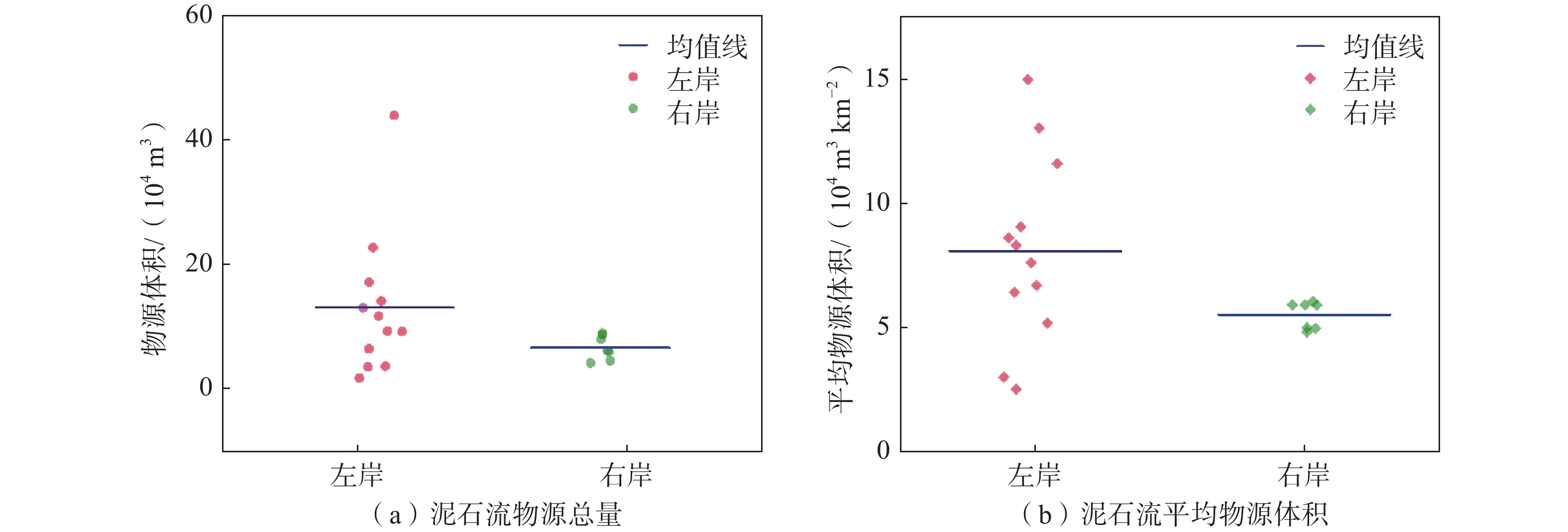
根据现场调查,哇曲中游共发育泥石流19条,均为降雨型泥石流,空间上主要分布在加赤托—库木段(图2),呈带状分布,发育密度0.84 条/km,贡觉县内泥石流发育密度为0.009 处/km2,发育密度远大于全县平均水平。其中,哇曲左岸分布泥石流12条,占比63.2%,右岸发育泥石流7条,占比36.8%,泥石流集中发育在哇曲左岸(表1),差异分布特征明显。
![]() 图 2 哇曲中游泥石流分布图Figure 2. Distribution map of debris flows in the middle reaches of Waqu River表 1 哇曲中游泥石流特征参数Table 1. Characteristic parameters of debris flows in the middle reaches of Waqu River
图 2 哇曲中游泥石流分布图Figure 2. Distribution map of debris flows in the middle reaches of Waqu River表 1 哇曲中游泥石流特征参数Table 1. Characteristic parameters of debris flows in the middle reaches of Waqu River编号 岸别 流域
面积/km2主沟
长度/km流域
高差/m主沟
纵比降/‰累计堆积
体积/m301 左岸 2.06 1.77 760 191 8 492 02 左岸 0.78 1.49 688 247 6 461 03 左岸 2.51 2.10 716 193 48 550 04 左岸 0.79 1.28 628 309 38 922 05 左岸 1.51 1.96 597 212 86 558 06 左岸 0.71 1.54 579 297 3 454 07 左岸 1.85 1.93 653 225 23 717 08 左岸 0.54 1.52 675 355 7 778 09 左岸 0.54 1.48 593 293 6 186 10 左岸 8.50 3.51 722 153 21 259 11 左岸 2.56 3.10 618 142 10 791 12 左岸 0.57 1.06 600 228 31 265 13 右岸 1.01 1.19 596 226 2 430 14 右岸 0.65 1.01 538 290 10 742 15 右岸 0.70 1.25 580 269 4 772 16 右岸 1.34 1.35 589 258 10 823 17 右岸 1.79 1.81 661 169 1 722 18 右岸 1.80 2.93 680 135 39 312 19 右岸 1.19 2.03 503 139 9 687 2.1 泥石流地形特征
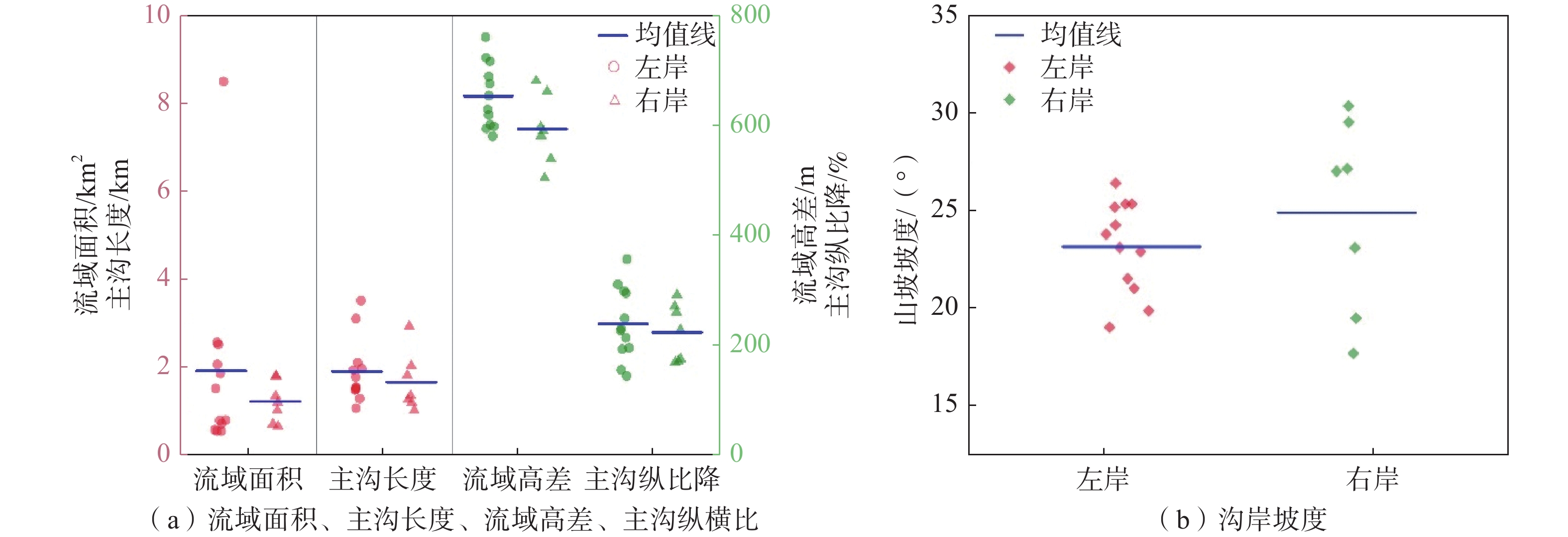
研究区泥石流流域面积主要集中在0.5~3 km2,主沟长度多小于2 km,呈现小流域特点。流域高差分布在500~800 m,主沟纵比降集中在150‰~300‰,平均沟岸坡度25°左右,局部大于50°,地形较为陡峻。对比左右岸泥石流地形特征发现(图3),左岸泥石流在流域面积、流域高差、主沟长度和主沟纵比降上略大于(高于)右岸泥石流,山坡坡度右岸略高,近乎一致。总体上,两岸泥石流地形条件基本一致。
2.2 泥石流堆积特征
经遥感解译、无人机航拍和现场调查,圈定了19条泥石流的堆积区,研究区内泥石流堆积物均分布于现代河谷内,边界清晰,堆积物可辨。哇曲左右两岸泥石流堆积物在堆积物粒径、堆积厚度和范围、堆积物原岩岩性等特征上均有不同,见图4(a)。
![]() 图 4 左右岸泥石流堆积物差异特征注:a 为左右岸泥石流堆积范围(镜向75°);b 为左岸泥石流堆积物(镜向40°);c为右岸泥石流堆积物(镜向45°)。Figure 4. Differential characteristics of debris flow deposits on the left and right banks
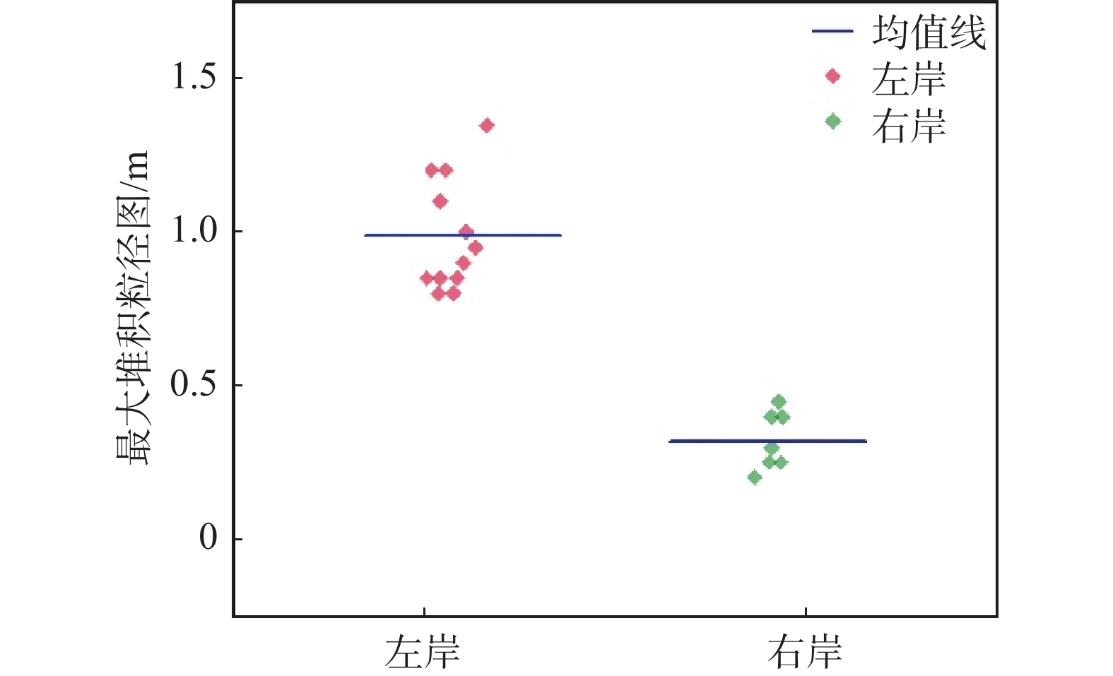
图 4 左右岸泥石流堆积物差异特征注:a 为左右岸泥石流堆积范围(镜向75°);b 为左岸泥石流堆积物(镜向40°);c为右岸泥石流堆积物(镜向45°)。Figure 4. Differential characteristics of debris flow deposits on the left and right banks在堆积物物质组成和粒径方面,左岸泥石流堆积物为块碎石土或碎块石土,右岸为碎石土或砾石土,分选性好,磨圆差,左岸堆积物最大粒径和平均粒径均明显大于右岸泥石流堆积物(图5)。根据现场调查,左岸堆积物中块石碎石原岩岩性多为灰岩,来源于沟域中上游的T3b地层,粒径较大,少量砂岩来源于沟域中的T3j地层,见图4(b)。右岸堆积物由砂岩和粉砂岩组成,粒径小,分选性好,见图4(c)。灰岩的参与直接影响了两岸堆积物粒径和物质组成。
![]() 图 5 研究区泥石流最大堆积粒径图Figure 5. Maximum deposit particle size of debris flow in the study area
图 5 研究区泥石流最大堆积粒径图Figure 5. Maximum deposit particle size of debris flow in the study area在堆积厚度和堆积体积方面,左岸泥石流堆积厚度在1~2.5 m,平均堆积体积为24 450 m3,而右岸泥石流堆积厚度多约1 m,部分泥石流小于0.5 m,平均堆积体积为11 350 m3。
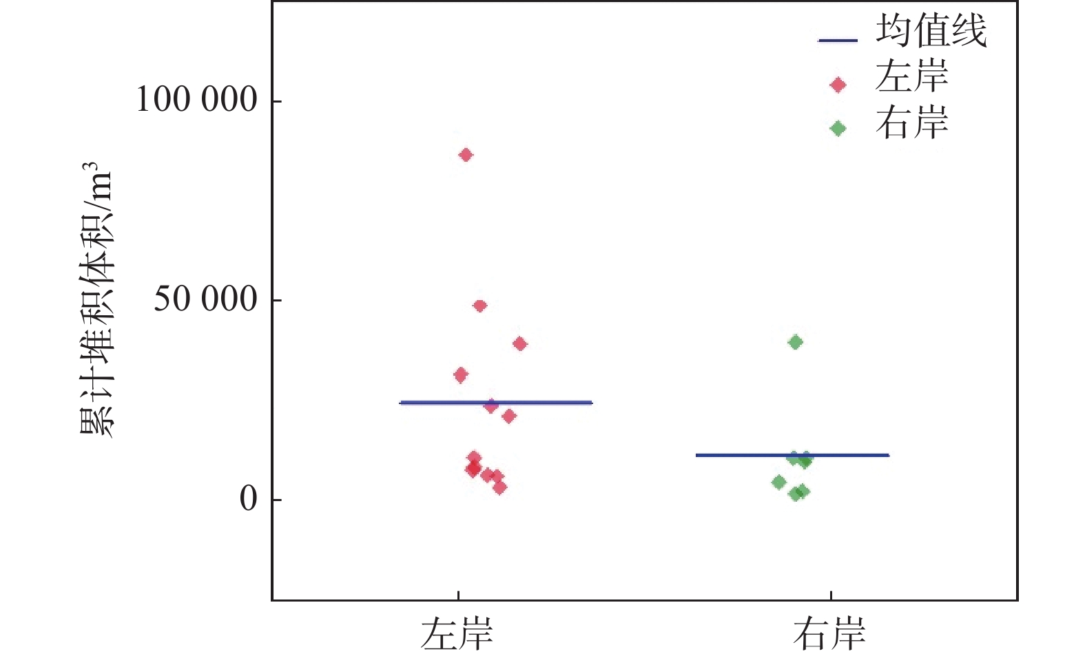
左岸堆积厚度和堆积体积较右岸大(图6),这和泥石流物源类型有直接关系。右岸泥石流物源几乎全部来源于岩体风化碎屑,颗粒较细,更易启动。左岸泥石流物源除风化碎屑外还有断层破碎带内的岩体崩落,粒径较大,物源储量更大,泥石流规模更大。现场调查发现,左岸部分泥石流呈现多期堆积特征,单次堆积厚度更大。堆积范围影响了堆积长度,右岸泥石流堆积区长度更长。两岸泥石流沟道与主河近乎正交,堆积扇冲入主河内均对河道造成不同程度地挤压,交汇处主河发生弯曲偏移。
![]() 图 6 研究区泥石流累计堆积体积Figure 6. Cumulative deposit volume of debris flows in the study area
图 6 研究区泥石流累计堆积体积Figure 6. Cumulative deposit volume of debris flows in the study area2.3 泥石流物源特征
通过遥感解译和现场调查复核发现,哇曲中游右岸泥石流以风化碎屑物源为主,呈全流域分布,平均厚度小。左岸泥石流以断层破碎带内的崩滑物源、风化物源和其余流域内的风化碎屑物源为主,平均厚度大,集中分布在流域中上部。为计算流域内物源储量(静储量),对断层破碎带内的物源采用剖面简化计算模型[30 − 31],即以典型剖面上堆积物分布面积和沟谷内断层破碎带出露长度的乘积计算物源量,见图7、式1。风化碎屑物源采用现场调查的碎屑平均厚度和碎屑分布面积乘积计算,具体结果见表2。
表 2 泥石流物源储量Table 2. Debris flow source material reserves编号 岸别 物源体积/m3 破碎带内物源占比/% 01 左岸 171 413 70 02 左岸 116 969 83 03 左岸 227 473 73 04 左岸 91 716 79 05 左岸 130 084 71 06 左岸 92 651 81 07 左岸 140 969 67 08 左岸 34 633 65 09 左岸 36 111 62 10 左岸 440 095 52 11 左岸 64 100 — 12 左岸 17 040 — 13 右岸 61 230 — 14 右岸 38 395 — 15 右岸 41 390 — 16 右岸 79 340 — 17 右岸 89 430 — 18 右岸 86 785 — 19 右岸 59 100 — $$ Q = {S_1} \times H + {S_2} \times L $$ (1) 式中:Q——物源量/m3;
S1——碎屑物源分布面积/m2;
H——碎屑物源平均厚度/m;
S2——计算剖面上物源面积/m2;
L——沟谷内断层出露长度/m。
由物源统计表可得,左岸泥石流物源平均总储量为13.0×10⁴ m3,右岸为6.5×10⁴ m3。平均单位面积物源储量方面,左岸泥石流为8.1×10⁴ m3/km2,右岸为5.5×104 m3/km2,平均总储量和平均单位面积物源储量左岸泥石流明显大于右岸泥石流(图8)。其中,左岸泥石流断层破碎带提供的物源占比为52%~83%,成为左岸泥石流形成的主要物源,也是影响左右岸泥石流物源差异分布的重要原因。
3. 断裂构造对物源条件控制作用
影响泥石流形成的三大条件中,降雨在研究区小流域范围内分布特征无明显变化,对泥石流差异分布影响程度微弱。根据2.2节中分析,研究区左右岸泥石流在主沟纵比降和山坡坡度最重要的地形因子上基本一致,地形条件相似。因此,影响泥石流差异分布的为物源条件。结合现场调查和流域地质背景,研究区断裂发育,影响泥石流物源条件的最重要因素为断裂构造。
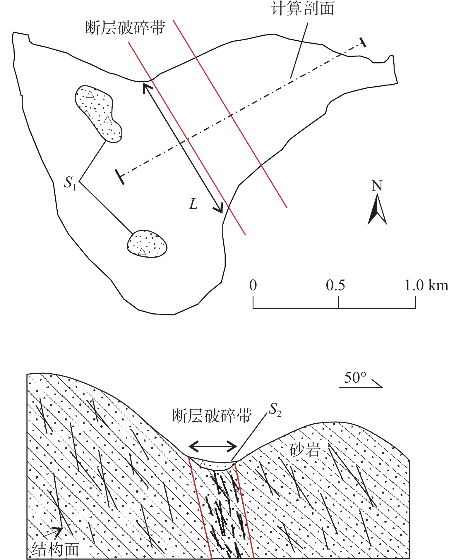
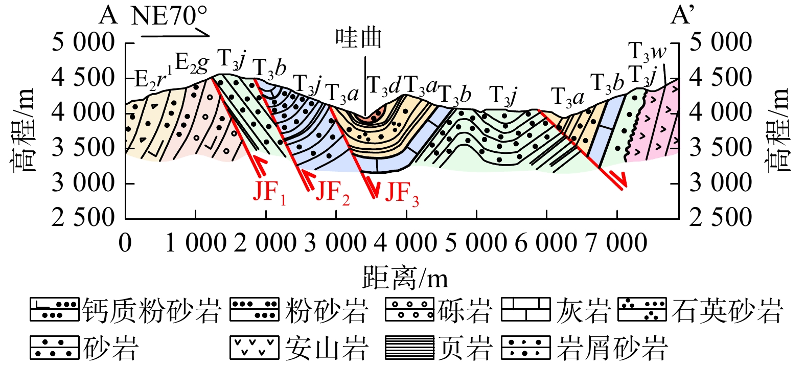
经现场调查发现,流域内主要发育阿纳卓巴向斜,左岸发育的三条断层(JF1、JF2、JF3)为金沙江缝合带西界断裂及其分支断层(图9)。
![]() 图 9 研究区地质背景剖面图(剖面位置见图2中的A-A’)Figure 9. Geological background profile of the study area (Profile Location indicated by A-A’ in Figure 2)
图 9 研究区地质背景剖面图(剖面位置见图2中的A-A’)Figure 9. Geological background profile of the study area (Profile Location indicated by A-A’ in Figure 2)JF1断裂为逆冲断裂,走向NNW向,断裂面倾向NEE,倾角位于45°~60°,该断裂的南端被NW向次级断裂所切割。研究区内断裂北段北东盘(上盘)主要以三叠系下统地层为主,少量古近系地层,南西盘(下盘)由古近系地层组成;断裂南段两侧均为三叠系地层。沿该断裂见陡崖的发育。卡多拉多断裂破碎带宽50~200 m,以脆性地层破裂为主。断裂上下两盘的地层产状错杂。研究表明JF1断裂第四系以来可能不再具有活动性,部分段落具有Qh活动性[32]。JF2断层为逆冲断层,走向和JF1断层基本一致为NNW向,上盘(北东盘)为波里拉组(T3b),下盘为甲丕拉组(T3j),沿该断层见坡中谷地形发育,有渗水点线状分布,破碎带宽度约180 m,全新世以来无明显活动迹象。JF3断层现场迹象不明显,未见断层破碎带,对研究区影响小。阿纳卓巴向斜轴向NNW向,略弯曲,南东端昂起。枢纽起伏弯曲,轴面近直立。核部地层为夺盖拉组(T3d),两翼由甲丕拉组(T3j)、波里拉组(T3b)、阿堵拉组(T3a)组成。两翼次级背斜向斜发育,西翼被JF2、JF3断层所切,东翼较完整。现场调查获取的3条断层的基本参数见表3。
表 3 流域内断层特征参数Table 3. Characteristic parameters of faults within the watershed断层编号 性质 走向/(°) 破碎带宽度/m 活动性 JF1 逆冲 320 200 更新世 JF2 逆冲 335 180 更新世 JF3 正断层 330 — 更新世 断裂构造控制研究区内泥石流物源发育主要体现在改变岩体结构、控制地层分布、改变微地貌和地下水条件四个方面。
3.1 改变岩体结构
研究区内岩体发育多组结构面,根据35处岩体结构面产状的统计结果,两组优势结构面在空间上的产出状态和区域主应力有较好的对应关系,见图10(c),说明受区域挤压应力作用,研究区内岩体出现变形破坏,形成多组结构面。J1、J2和岩层层面的组合切割下,形成了层状碎裂状的基本岩体结构,见图10(a)。
哇曲左岸处于哇曲向斜SW翼中,次级褶皱发育,处于褶皱转折端的岩体内发育一系列的纵张节理、压性节理和横向节理,短而密集,岩体破碎,这成为泥石流发育的前提条件。岩体沿破裂面逆冲形成叠瓦状的JF1和JF2断层(图9),局部出现牵引褶皱,断层面陡立,倾向NE。JF2断层刚好穿过向斜的转折端位置,破碎带内岩体软弱结构面异常发育,岩体多呈碎裂—散体结构,完整性极差,见图10(b)。哇曲右岸无断层穿过,斜坡岩体完整性较左岸好。
通过计算左右岸泥石流范围内切割密度(单位面积内包含的侵蚀网长度),左岸切割密度大于右岸(左岸8.33 km/km2,右岸5.02 km/km2),这和左岸岩体结构和岩体质量有直接关系。构造改变了泥石流形成区的岩体结构,降低岩体强度,为降雨入渗提供了天然通道,同时加速了岩体风化速率和地表剥蚀速率,右岸泥石流沟内碎屑物质积累速率小于左岸,这成为左岸泥石流规模比右岸泥石流更大的重要原因。
构造影响范围内的破碎岩体成为泥石流源源不断的物源,物源储量和构造性质、规模等有直接关系,尤其以断层作用为主。一般认为大型断层破碎带更宽,影响范围更广[33 − 34],更易形成大型物源或灾害。研究区内JF1、JF2断层属小型断层,该区泥石流规模为中、小型和此特征相对应。
3.2 控制地层分布
褶皱作用使得流域内地层连续变形,形成了一系列不同倾角不同倾向的地层,走向与褶皱轴迹平行,呈NW—NNW向条带状分布,这成为流域内地层分布的基本框架。左岸断层逆冲作用导致上三叠统甲丕拉组T3j和波里拉组T3b地层以高角度推覆在阿堵拉组T3a和夺盖拉组T3d地层之上,该构造作用直接决定了研究区的地层分布情况,即左岸地层以T3j、T3b为主,右岸以T3a、T3d为主。
哇曲左岸泥石流形成区地层岩性主要为T3b和T3j的灰岩砂岩,哇曲右岸则为T3a和T3d的砂岩粉砂岩(图2)。左岸灰岩的岩石坚固系数大于砂岩[35](灰岩10.0,砂岩5.0~6.0),两者形成了上硬下软的岩体结构,在相同自然营力条件下,砂岩抗风化能力较弱,风化程度较灰岩高,加之岩体破碎,在灰岩之下往往形成岩体凹腔,使得上覆灰岩凸出地表,似孤立岩体,见图11(a)。根据现场调查,褶皱作用形成了陡倾岩层,岩层倾角多在40°~65°,局部达60°~82°,大倾角岩体在自重作用下易于崩滑,堆积于坡脚或进入沟道,见图11(b),沟内储存较大量物源。哇曲右岸主要出露T3a和T3d地层的砂岩和粉砂岩,岩体风化程度较为统一,风化物质均为细颗粒,无崩滑类斜坡物源参与下难以汇集大量物源,这使得右岸泥石流在物源储量上普遍小于左岸泥石流。
![]() 图 11 灰岩崩落注:(a) 为灰岩突出地表崩落,镜向350°;(b) 为构造内灰岩,镜向233°。Figure 11. Schematic view of limestone collapse
图 11 灰岩崩落注:(a) 为灰岩突出地表崩落,镜向350°;(b) 为构造内灰岩,镜向233°。Figure 11. Schematic view of limestone collapse有灰岩参与的左岸泥石流在堆积体积、堆积物平均粒径、堆积厚度都明显大于(多于)其他岩性参与的右岸泥石流。灰岩是泥石流的重要物源,也是影响泥石流规模的重要岩体。
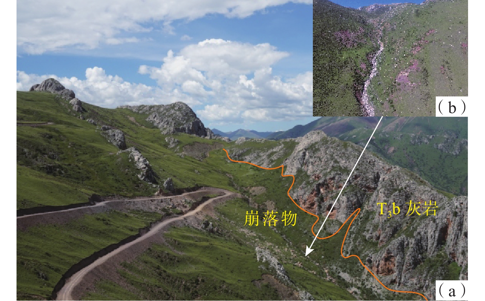
3.3 改变微地貌
受区域挤压应力作用,岩层褶皱形成哇曲复向斜,后续发育为哇曲河谷,两岸斜坡较为陡立。左岸两条断层以高角度逆冲推覆改变了斜坡地形,左岸斜坡起伏度更大。断层通过处断层破碎带地貌特征明显,经长年风化剥蚀形成坡中谷地形,见图12(a),斜坡局部近直立,似陡崖。右岸无断层穿过,斜坡较为平整,无明显起伏,见图12(b)。
![]() 图 12 哇曲左岸断层地貌特征Figure 12. Geomorphic features of fault on the left bank of Waqu river
图 12 哇曲左岸断层地貌特征Figure 12. Geomorphic features of fault on the left bank of Waqu river断层改变了左岸的微地貌,斜坡中部形成沟谷,越靠近断层面,地貌改变越明显。坡中谷地貌为岩体崩落提供了势能条件,顺斜坡向上下两侧断层通过处的坡中谷已成为流域内部分泥石流沟的重要支沟,沟内堆积大量物源有利于泥石流的形成。
3.4 改变地下水条件
哇曲左岸的断层破碎带形成了地下水的重要赋存和流动通道,此部位的地下水属于基岩裂隙水,在左岸斜坡中顺主河呈带状分布,宽度变化不均。破碎带岩体中裂隙密集发育,形成了一个较大的储水空间,裂隙又相互交错限制,空间延伸长度不一,因此破碎带内富水呈现不均匀性。
断层破碎带内岩体破碎,降雨和地表径流容易入渗,地下水受地表水补给程度高,经长期溶蚀和机械冲刷作用,左岸断层破碎带内的灰岩砂岩等出现强度衰减,稳定性降低。在现场调查中发现多处渗水点(图13),表明该处地下水位较高,较为富水,岩体长期处于浸泡软化状态。哇曲左岸断层一定程度上改变了断层通过处的地下水条件,改变了地下水位和富水性,改变了水循环系统,加速了渗流,降低了岩体强度,易于崩滑形成新的物源。
![]() 图 13 岩体渗水特征(镜向150°)Figure 13. Seepage characteristics of rock mass (Mirror Direction 150°)
图 13 岩体渗水特征(镜向150°)Figure 13. Seepage characteristics of rock mass (Mirror Direction 150°)4. 结论
文中选取贡觉县哇曲中游19条泥石流进行地面调查和遥感解译,对其发育特征和物源控制因素分析发现:
(1)哇曲中游集中发育19条小—中型降雨型泥石流,发育密度0.84 条/km,远高于贡觉县其他地区。其中左岸泥石流发育密度为1.10 条/km,右岸0.63条/km,同时左岸泥石流在流域面积、主沟长度、堆积体积、堆积物平均粒径和厚度等特征上均高于(大于)右岸,呈明显差异分布。
(2)研究区内右岸泥石流物源以风化碎屑为主,呈全沟域分布,平均静储量为65 096 m3。左岸泥石流物源以崩滑物源和风化碎屑为主,平均静储量为130269 m3,左岸泥石流物源储量明显大于右岸,其中断层破碎带内物源量占比52%~83%,集中分布在流域中上游,成为左岸泥石流的主要物源。
(3)断裂控制了左岸的地层分布,同时形成层状—破碎—散体状岩体,断层破碎带形成的坡中谷地貌使得灰岩易于崩落,砂岩易于风化,加之地下水条件的改变,降低岩体强度,形成大量物源。断裂构造以改变岩体结构、控制地层分布、改变微地貌和改变地下水条件四种方式控制了物源条件,成为左右岸泥石流物源积累速率和物源量差异的根本原因。
(4)贡觉县内断裂褶皱发育,岩体破碎,金沙江西界断裂从县内穿过,相似地质环境区分布范围较广,应注意此类泥石流的暴发。
-
![]()
![]()
图 2 哇曲中游泥石流分布图
Figure 2. Distribution map of debris flows in the middle reaches of Waqu River
![]()
图 4 左右岸泥石流堆积物差异特征
注:a 为左右岸泥石流堆积范围(镜向75°);b 为左岸泥石流堆积物(镜向40°);c为右岸泥石流堆积物(镜向45°)。
Figure 4. Differential characteristics of debris flow deposits on the left and right banks
![]()
图 5 研究区泥石流最大堆积粒径图
Figure 5. Maximum deposit particle size of debris flow in the study area
![]()
图 6 研究区泥石流累计堆积体积
Figure 6. Cumulative deposit volume of debris flows in the study area
![]()
图 9 研究区地质背景剖面图(剖面位置见图2中的A-A’)
Figure 9. Geological background profile of the study area (Profile Location indicated by A-A’ in Figure 2)
![]()
图 11 灰岩崩落
注:(a) 为灰岩突出地表崩落,镜向350°;(b) 为构造内灰岩,镜向233°。
Figure 11. Schematic view of limestone collapse
![]()
图 12 哇曲左岸断层地貌特征
Figure 12. Geomorphic features of fault on the left bank of Waqu river
![]()
图 13 岩体渗水特征(镜向150°)
Figure 13. Seepage characteristics of rock mass (Mirror Direction 150°)
表 1 哇曲中游泥石流特征参数
Table 1 Characteristic parameters of debris flows in the middle reaches of Waqu River
编号 岸别 流域
面积/km2主沟
长度/km流域
高差/m主沟
纵比降/‰累计堆积
体积/m301 左岸 2.06 1.77 760 191 8 492 02 左岸 0.78 1.49 688 247 6 461 03 左岸 2.51 2.10 716 193 48 550 04 左岸 0.79 1.28 628 309 38 922 05 左岸 1.51 1.96 597 212 86 558 06 左岸 0.71 1.54 579 297 3 454 07 左岸 1.85 1.93 653 225 23 717 08 左岸 0.54 1.52 675 355 7 778 09 左岸 0.54 1.48 593 293 6 186 10 左岸 8.50 3.51 722 153 21 259 11 左岸 2.56 3.10 618 142 10 791 12 左岸 0.57 1.06 600 228 31 265 13 右岸 1.01 1.19 596 226 2 430 14 右岸 0.65 1.01 538 290 10 742 15 右岸 0.70 1.25 580 269 4 772 16 右岸 1.34 1.35 589 258 10 823 17 右岸 1.79 1.81 661 169 1 722 18 右岸 1.80 2.93 680 135 39 312 19 右岸 1.19 2.03 503 139 9 687  下载: 导出CSV
表 2 泥石流物源储量
Table 2 Debris flow source material reserves
编号 岸别 物源体积/m3 破碎带内物源占比/% 01 左岸 171 413 70 02 左岸 116 969 83 03 左岸 227 473 73 04 左岸 91 716 79 05 左岸 130 084 71 06 左岸 92 651 81 07 左岸 140 969 67 08 左岸 34 633 65 09 左岸 36 111 62 10 左岸 440 095 52 11 左岸 64 100 — 12 左岸 17 040 — 13 右岸 61 230 — 14 右岸 38 395 — 15 右岸 41 390 — 16 右岸 79 340 — 17 右岸 89 430 — 18 右岸 86 785 — 19 右岸 59 100 —
下载: 导出CSV
表 3 流域内断层特征参数
Table 3 Characteristic parameters of faults within the watershed
断层编号 性质 走向/(°) 破碎带宽度/m 活动性 JF1 逆冲 320 200 更新世 JF2 逆冲 335 180 更新世 JF3 正断层 330 — 更新世
下载: 导出CSV
-
[1] 余斌,唐川. 泥石流动力特性与活动规律研究[M]. 北京:科学出版社,2016. [YU Bin,TANG Chuan. Dynamic characteristics and activity law of debris flow[M]. Beijing:Science Press,2016. (in Chinese) YU Bin, TANG Chuan. Dynamic characteristics and activity law of debris flow[M]. Beijing: Science Press, 2016. (in Chinese)
[2] 陈宁生,田树峰,张勇,等. 泥石流灾害的物源控制与高性能减灾[J]. 地学前缘,2021,28(4):337 − 348. [CHEN Ningsheng,TIAN Shufeng,ZHANG Yong,et al. Soil mass domination in debris-flow disasters and strategy for hazard mitigation[J]. Earth Science Frontiers,2021,28(4):337 − 348. (in Chinese with English abstract) CHEN Ningsheng, TIAN Shufeng, ZHANG Yong, et al . Soil mass domination in debris-flow disasters and strategy for hazard mitigation[J]. Earth Science Frontiers,2021 ,28 (4 ):337 −348 . (in Chinese with English abstract)[3] 唐永仪. 新构造运动在陇南滑坡泥石流形成中的作用[J]. 兰州大学学报,1992,28(4):152 − 160. [TANG Yongyi. The effect of neotectonic movement on formations of landslide and debris flow in southern Gansu[J]. Journal of Lanzhou University (Natural Science Edition),1992,28(4):152 − 160. (in Chinese with English abstract) TANG Yongyi . The effect of neotectonic movement on formations of landslide and debris flow in southern Gansu[J]. Journal of Lanzhou University (Natural Science Edition),1992 ,28 (4 ):152 −160 . (in Chinese with English abstract)[4] 黄润秋,李为乐. 汶川大地震触发地质灾害的断层效应分析[J]. 工程地质学报,2009,17(1):19 − 28. [HUANG Runqiu,LI Weile. Fault effect analysis of geo-hazard triggered by Wenchuan earthquake[J]. Journal of Engineering Geology,2009,17(1):19 − 28. (in Chinese with English abstract) DOI: 10.3969/j.issn.1004-9665.2009.01.003 HUANG Runqiu, LI Weile . Fault effect analysis of geo-hazard triggered by Wenchuan earthquake[J]. Journal of Engineering Geology,2009 ,17 (1 ):19 −28 . (in Chinese with English abstract) DOI: 10.3969/j.issn.1004-9665.2009.01.003[5] 黄润秋,李为乐. “5·12”汶川大地震触发地质灾害的发育分布规律研究[J]. 岩石力学与工程学报,2008,27(12):2585 − 2592. [HUANG Runqiu,LI Weile. Research on development and distribution rules of geohazards induced by Wenchuan earthquake on 12th May,2008[J]. Chinese Journal of Rock Mechanics and Engineering,2008,27(12):2585 − 2592. (in Chinese with English abstract) DOI: 10.3321/j.issn:1000-6915.2008.12.028 HUANG Runqiu, LI Weile . Research on development and distribution rules of geohazards induced by Wenchuan earthquake on 12th May, 2008[J]. Chinese Journal of Rock Mechanics and Engineering,2008 ,27 (12 ):2585 −2592 . (in Chinese with English abstract) DOI: 10.3321/j.issn:1000-6915.2008.12.028[6] LIU Hongjiang,LAN Hengxing,LIU Yi,et al. Characteristics of spatial distribution of debris flow and the effect of their sediment yield in main downstream of Jinsha River,China[J]. Environmental Earth Sciences,2011,64(6):1653 − 1666. DOI: 10.1007/s12665-009-0409-6
[7] 张永双,郭长宝,姚鑫,等. 青藏高原东缘活动断裂地质灾害效应研究[J]. 地球学报,2016,37(3):277 − 286. [ZHANG Yongshuang,GUO Changbao,YAO Xin,et al. Research on the geohazard effect of active fault on the eastern margin of the Tibetan Plateau[J]. Acta Geoscientica Sinica,2016,37(3):277 − 286. (in Chinese with English abstract) ZHANG Yongshuang, GUO Changbao, YAO Xin, et al . Research on the geohazard effect of active fault on the eastern margin of the Tibetan Plateau[J]. Acta Geoscientica Sinica,2016 ,37 (3 ):277 −286 . (in Chinese with English abstract)[8] 石建军,李保珠,李鹏,等. 元谋大断裂对东山地区泥石流发育的控制作用[J]. 水土保持通报,2017,37(4):58 − 62. [SHI Jianjun,LI Baozhu,LI Peng,et al. Controlling effect of Yuanmou major fracture on debris flow development in Dongshan area[J]. Bulletin of Soil and Water Conservation,2017,37(4):58 − 62. (in Chinese with English abstract) SHI Jianjun, LI Baozhu, LI Peng, et al . Controlling effect of Yuanmou major fracture on debris flow development in Dongshan area[J]. Bulletin of Soil and Water Conservation,2017 ,37 (4 ):58 −62 . (in Chinese with English abstract)[9] 张永双,任三绍,郭长宝,等. 活动断裂带工程地质研究[J]. 地质学报,2019,93(4):763 − 775. [ZHANG Yongshuang,REN Sanshao,GUO Changbao,et al. Research on engineering geology related with active fault zone[J]. Acta Geologica Sinica,2019,93(4):763 − 775. (in Chinese with English abstract) ZHANG Yongshuang, REN Sanshao, GUO Changbao, et al . Research on engineering geology related with active fault zone[J]. Acta Geologica Sinica,2019 ,93 (4 ):763 −775 . (in Chinese with English abstract)[10] ZOU Yu,QI Shengwen,GUO Songfeng,et al. Factors controlling the spatial distribution of coseismic landslides triggered by the Mw 6.1 Ludian earthquake in China[J]. Engineering Geology,2022,296:106477. DOI: 10.1016/j.enggeo.2021.106477
[11] 郭剑,李天涛,孙金坤. 安县高川河流域泥石流物源特征及其活动量预测[J]. 水电能源科学,2015,33(7):151 − 155. [GUO Jian,LI Tiantao,SUN Jinkun. Characteristics of debris flow provenance and activity prediction of Gaochuan River Basin in Anxian County[J]. Water Resources and Power,2015,33(7):151 − 155. (in Chinese with English abstract) GUO Jian, LI Tiantao, SUN Jinkun . Characteristics of debris flow provenance and activity prediction of Gaochuan River Basin in Anxian County[J]. Water Resources and Power,2015 ,33 (7 ):151 −155 . (in Chinese with English abstract)[12] Ma Chao. The rainstorm conditions triggering debris flows in the mountain regions surrounding Beijing: [C]. Katlenburg-Lindau, The EGU General Assembly 2017, 2017.
[13] 付智勇,龙晶晶,常鸣. 汶川地震前后四川都江堰龙池镇地区泥石流物源分布特征及其演化规律[J]. 中国地质灾害与防治学报,2019,30(6):10 − 19. [FU Zhiyong,LONG Jingjing,CHANG Ming. Distribution characteristics and evolution rules of sediment supply for debris flow occurrence around Longchi Town of Dujiangyan City,Sichuan Province[J]. The Chinese Journal of Geological Hazard and Control,2019,30(6):10 − 19. (in Chinese with English abstract) FU Zhiyong, LONG Jingjing, CHANG Ming . Distribution characteristics and evolution rules of sediment supply for debris flow occurrence around Longchi Town of Dujiangyan City, Sichuan Province[J]. The Chinese Journal of Geological Hazard and Control,2019 ,30 (6 ):10 −19 . (in Chinese with English abstract)[14] 王振涛,吴和秋,张明,等. 新疆乌恰县泥石流分布规律与主控因素研究[J]. 人民长江,2020,51(8):44 − 49. [WANG Zhentao,WU Heqiu,ZHANG Ming,et al. Distribution and main controlling factors of debris flows in Wuqia County,Xinjiang Autonomous Region[J]. Yangtze River,2020,51(8):44 − 49. (in Chinese with English abstract) WANG Zhentao, WU Heqiu, ZHANG Ming, et al . Distribution and main controlling factors of debris flows in Wuqia County, Xinjiang Autonomous Region[J]. Yangtze River,2020 ,51 (8 ):44 −49 . (in Chinese with English abstract)[15] 秦宇龙,吴建亮,詹涵钰,等. 川西甘孜地区活动断裂与地质灾害分布相关性探讨[J]. 地质力学学报,2021,27(3):463 − 474. [QIN Yulong,WU Jianliang,ZHAN Hanyu,et al. Discussion on the correlation between active faults and geological disasters in Ganzi area of western Sichuan[J]. Journal of Geomechanics,2021,27(3):463 − 474. (in Chinese with English abstract) DOI: 10.12090/j.issn.1006-6616.2021.27.03.042 QIN Yulong, WU Jianliang, ZHAN Hanyu, et al . Discussion on the correlation between active faults and geological disasters in Ganzi area of western Sichuan[J]. Journal of Geomechanics,2021 ,27 (3 ):463 −474 . (in Chinese with English abstract) DOI: 10.12090/j.issn.1006-6616.2021.27.03.042[16] 李光辉,铁永波,白永建,等. 则木河断裂带(普格段)地质灾害发育规律及易发性评价[J]. 中国地质灾害与防治学报,2022,33(3):123 − 133. [LI Guanghui,TIE Yongbo,BAI Yongjian,et al. Distribution and susceptibility assessment of geological hazards in Zemuhe fault zone(Puge section)[J]. The Chinese Journal of Geological Hazard and Control,2022,33(3):123 − 133. (in Chinese with English abstract) LI Guanghui, TIE Yongbo, BAI Yongjian, et al . Distribution and susceptibility assessment of geological hazards in Zemuhe fault zone(Puge section)[J]. The Chinese Journal of Geological Hazard and Control,2022 ,33 (3 ):123 −133 . (in Chinese with English abstract)[17] 顾文韬,裴向军,裴钻,等. 极震区震后泥石流物源特征研究[J]. 自然灾害学报,2015,24(2):107 − 114. [GU Wentao,PEI Xiangjun,PEI Zuan,et al. Research on post-seismic provenance features of debris flows in meizoseismal area[J]. Journal of Natural Disasters,2015,24(2):107 − 114. (in Chinese with English abstract) GU Wentao, PEI Xiangjun, PEI Zuan, et al . Research on post-seismic provenance features of debris flows in meizoseismal area[J]. Journal of Natural Disasters,2015 ,24 (2 ):107 −114 . (in Chinese with English abstract)[18] 常鸣,唐川,李为乐,等. 汶川地震区绵远河流域泥石流形成区的崩塌滑坡特征[J]. 山地学报,2012,30(5):561 − 569. [CHANG Ming,TANG Chuan,LI Weile,et al. The characteristic of collapse and landslide by Wenchuan earthquake in debris flow for mative region along the Mianyuan River Basin,China[J]. Journal of Mountain Science,2012,30(5):561 − 569. (in Chinese with English abstract) CHANG Ming, TANG Chuan, LI Weile, et al . The characteristic of collapse and landslide by Wenchuan earthquake in debris flow for mative region along the Mianyuan River Basin, China[J]. Journal of Mountain Science,2012 ,30 (5 ):561 −569 . (in Chinese with English abstract)[19] 刘美,陈宁生,赵春瑶. 断裂构造对金沙江巧家至蒙姑段泥石流发育影响研究[J]. 自然灾害学报,2018,27(3):136 − 143. [LIU Mei,CHEN Ningsheng,ZHAO Chunyao. Influence of fault structure on debris flow in Qiaojia and Menggu section of the Jinsha River[J]. Journal of Natural Disasters,2018,27(3):136 − 143. (in Chinese with English abstract) LIU Mei, CHEN Ningsheng, ZHAO Chunyao . Influence of fault structure on debris flow in Qiaojia and Menggu section of the Jinsha River[J]. Journal of Natural Disasters,2018 ,27 (3 ):136 −143 . (in Chinese with English abstract)[20] 苏琦,梁明剑,袁道阳,等. 白龙江流域构造地貌特征及其对滑坡泥石流灾害的控制作用[J]. 地球科学,2016,41(10):1758 − 1770. [SU Qi,LIANG Mingjian,YUAN Daoyang,et al. Geomorphic features of the Bailongjiang River drainage basin and its relationship with geological disaster[J]. Earth Science,2016,41(10):1758 − 1770. (in Chinese with English abstract) SU Qi, LIANG Mingjian, YUAN Daoyang, et al . Geomorphic features of the Bailongjiang River drainage basin and its relationship with geological disaster[J]. Earth Science,2016 ,41 (10 ):1758 −1770 . (in Chinese with English abstract)[21] 高延超,陈宁生,葛华,等. 康定市子耳沟泥石流的物源特征与危险区划[J]. 水土保持研究,2018,25(6):403 − 407. [GAO Yanchao,CHEN Ningsheng,GE Hua,et al. Source characteristic and risk zoning of debris flow in Zier watershed of Kangding City[J]. Research of Soil and Water Conservation,2018,25(6):403 − 407. (in Chinese with English abstract) GAO Yanchao, CHEN Ningsheng, GE Hua, et al . Source characteristic and risk zoning of debris flow in Zier watershed of Kangding City[J]. Research of Soil and Water Conservation,2018 ,25 (6 ):403 −407 . (in Chinese with English abstract)[22] 孙聿卿. 川藏公路北线泥石流风险评价[D]. 绵阳:西南科技大学,2021. [SUN Yuqing. Risk assessment of debris flow in the northern line of Sichuan-Tibet highway[D]. Mianyang:Southwest University of Science and Technology,2021. (in Chinese with English abstract) SUN Yuqing. Risk assessment of debris flow in the northern line of Sichuan-Tibet highway[D]. Mianyang: Southwest University of Science and Technology, 2021. (in Chinese with English abstract)
[23] ZHOU Hongfu,LIU Bin,YE Fei,et al. Landslide distribution and sliding mode control along the Anninghe fault zone at the eastern edge of the Tibetan Plateau[J]. Journal of Mountain Science,2021,18(8):2094 − 2107. DOI: 10.1007/s11629-020-6573-6
[24] 杨强,王高峰,李金柱,等. 白龙江中上游泥石流形成条件与成灾模式探讨[J]. 中国地质灾害与防治学报,2022,33(6):70 − 79. [YANG Qiang,WANG Gaofeng,LI Jinzhu,et al. Discussion on formation conditions and disaster mode of debris flow in the middle and upper reaches of Bailong River[J]. The Chinese Journal of Geological Hazard and Control,2022,33(6):70 − 79. (in Chinese with English abstract) YANG Qiang, WANG Gaofeng, LI Jinzhu, et al . Discussion on formation conditions and disaster mode of debris flow in the middle and upper reaches of Bailong River[J]. The Chinese Journal of Geological Hazard and Control,2022 ,33 (6 ):70 −79 . (in Chinese with English abstract)[25] 曹建文,龙昱,陈凌康,等. 贡觉县克西林沟泥石流特征及成因分析[J]. 安徽农业科学,2007,35(25):8065 − 8067. [CAO Jianwen,LONG Yu,CHEN Lingkang,et al. Study on characteristics and causes of debris flow in Kelinxi gully of Gongjue County[J]. Journal of Anhui Agricultural Sciences,2007,35(25):8065 − 8067. (in Chinese with English abstract) CAO Jianwen, LONG Yu, CHEN Lingkang, et al . Study on characteristics and causes of debris flow in Kelinxi gully of Gongjue County[J]. Journal of Anhui Agricultural Sciences,2007 ,35 (25 ):8065 −8067 . (in Chinese with English abstract)[26] ZHANG Yongshuang,CHENG Yuliang,YIN Yueping,et al. High-position debris flow:A long-term active geohazard after the Wenchuan earthquake[J]. Engineering Geology,2014,180:45 − 54. DOI: 10.1016/j.enggeo.2014.05.014
[27] 李孝攀,李远富,周先虎,等. 川藏铁路康定至昌都段地质灾害区域危险性评价[J]. 铁道标准设计,2017,61(6):58 − 62. [LI Xiaopan,LI Yuanfu,ZHOU Xianhu,et al. Evaluation of regional geological hazards risks on Kangding to Changdu section of Sichuan-Tibet railway[J]. Railway Standard Design,2017,61(6):58 − 62. (in Chinese with English abstract) LI Xiaopan, LI Yuanfu, ZHOU Xianhu, et al . Evaluation of regional geological hazards risks on Kangding to Changdu section of Sichuan-Tibet railway[J]. Railway Standard Design,2017 ,61 (6 ):58 −62 . (in Chinese with English abstract)[28] 孙梦宇. 断裂带构造损伤岩体对泥石流物源形成影响研究——以安宁河断裂带为例[D]. 成都:成都理工大学,2020. [SUN Mengyu. Study on the influence of structural damage rock mass in fault zone on the formation of debris flow provenance: A case study of Anninghe fault zone[D]. Chengdu:Chengdu University of Technology,2020. (in Chinese with English abstract) SUN Mengyu. Study on the influence of structural damage rock mass in fault zone on the formation of debris flow provenance: A case study of Anninghe fault zone[D]. Chengdu: Chengdu University of Technology, 2020. (in Chinese with English abstract)
[29] 尹福光,潘桂棠,孙志明. 西南三江构造体系及演化、成因[J]. 沉积与特提斯地质,2021,41(2):265 − 282. [YIN Fuguang,PAN Guitang,SUN Zhiming. Genesis and evolution of the structural systems during the Cenozoic in the Sanjiang orogenic belt,southwest China[J]. Sedimentary Geology and Tethyan Geology,2021,41(2):265 − 282. (in Chinese with English abstract) YIN Fuguang, PAN Guitang, SUN Zhiming . Genesis and evolution of the structural systems during the Cenozoic in the Sanjiang orogenic belt, southwest China[J]. Sedimentary Geology and Tethyan Geology,2021 ,41 (2 ):265 −282 . (in Chinese with English abstract)[30] 乔建平,黄栋,杨宗佶,等. 汶川地震极震区泥石流物源动储量统计方法讨论[J]. 中国地质灾害与防治学报,2012,23(2):1 − 6. [QIAO Jianping,HUANG Dong,YANG Zongji,et al. Statistical method on dynamic reserve of debris flow’s source materials in meizoseismal area of Wenchuan earthquake region[J]. The Chinese Journal of Geological Hazard and Control,2012,23(2):1 − 6. (in Chinese with English abstract) QIAO Jianping, HUANG Dong, YANG Zongji, et al . Statistical method on dynamic reserve of debris flow’s source materials in meizoseismal area of Wenchuan earthquake region[J]. The Chinese Journal of Geological Hazard and Control,2012 ,23 (2 ):1 −6 . (in Chinese with English abstract)[31] 张佳佳,刘建康,高波,等. 藏东南嘎龙曲冰川泥石流的物源特征及其对扎墨公路的影响[J]. 地质力学学报,2018,24(1):106 − 115. [ZHANG Jiajia,LIU Jiankang,GAO Bo,et al. Characteristics of material sources of galongqu glacial debris flow and the influence to Zhamo road[J]. Journal of Geomechanics,2018,24(1):106 − 115. (in Chinese with English abstract) DOI: 10.12090/j.issn.1006-6616.2018.24.01.012 ZHANG Jiajia, LIU Jiankang, GAO Bo, et al . Characteristics of material sources of galongqu glacial debris flow and the influence to Zhamo road[J]. Journal of Geomechanics,2018 ,24 (1 ):106 −115 . (in Chinese with English abstract) DOI: 10.12090/j.issn.1006-6616.2018.24.01.012[32] 吴富峣,蒋良文,张广泽,等. 川藏铁路金沙江断裂带北段第四纪活动特征探讨[J]. 高速铁路技术,2019,10(4):23 − 28. [WU Fuyao,JIANG Liangwen,ZHANG Guangze,et al. Discussion on quaternary activity characteristics of northern section of Jinshajiang fault zone along Sichuan-Tibet railway[J]. High Speed Railway Technology,2019,10(4):23 − 28. (in Chinese with English abstract) WU Fuyao, JIANG Liangwen, ZHANG Guangze, et al . Discussion on quaternary activity characteristics of northern section of Jinshajiang fault zone along Sichuan-Tibet railway[J]. High Speed Railway Technology,2019 ,10 (4 ):23 −28 . (in Chinese with English abstract)[33] 高孝巧,张达. 逆断层控制构造裂缝发育的力学机制模拟[J]. 地质力学学报,2015,21(1):47 − 55. [GAO Xiaoqiao,ZHANG Da. Numerical simulation of structural fractures controlled by reverse fault[J]. Journal of Geomechanics,2015,21(1):47 − 55. (in Chinese with English abstract) GAO Xiaoqiao, ZHANG Da . Numerical simulation of structural fractures controlled by reverse fault[J]. Journal of Geomechanics,2015 ,21 (1 ):47 −55 . (in Chinese with English abstract)[34] 翁剑桥,曾联波,吕文雅,等. 断层附近地应力扰动带宽度及其影响因素[J]. 地质力学学报,2020,26(1):39 − 47. [WENG Jianqiao,ZENG Lianbo,LYU Wenya,et al. Width of stress disturbed zone near fault and its influencing factors[J]. Journal of Geomechanics,2020,26(1):39 − 47. (in Chinese with English abstract) WENG Jianqiao, ZENG Lianbo, LYU Wenya, et al . Width of stress disturbed zone near fault and its influencing factors[J]. Journal of Geomechanics,2020 ,26 (1 ):39 −47 . (in Chinese with English abstract)[35] 余斌,褚胜名,朱渊,等. 风化作用对沟谷型泥石流发育环境的影响研究[J]. 水土保持通报,2013,33(6):51 − 56. [YU Bin,CHU Shengming,ZHU Yuan,et al. Impacts of weathering on formation of gullied debris flow[J]. Bulletin of Soil and Water Conservation,2013,33(6):51 − 56. (in Chinese with English abstract) YU Bin, CHU Shengming, ZHU Yuan, et al . Impacts of weathering on formation of gullied debris flow[J]. Bulletin of Soil and Water Conservation,2013 ,33 (6 ):51 −56 . (in Chinese with English abstract)


计量
- 文章访问数: 4267
- HTML全文浏览量: 2472
- PDF下载量: 128
 邮件订阅
邮件订阅 RSS
RSS