

Sensitivity and susceptibility assessment of geological hazard factors: A case study of Xinping County in the Ailao mountain area of Yunnan Province, China
-
摘要:
针对地质灾害敏感因子选取和易发性评价问题,为寻求适宜云南省哀牢山区地质灾害易发性评价分区方法,论文选择新平县为典型研究区,选择了工程地质岩组、距断裂距离、高程、坡度、坡向、距水系距离、距道路距离和地类等因子,应用证据权法进行了地质灾害因子敏感性分析和易发性评价。评价结果显示:地质灾害高易发区面积
1532.94 km2、灾点占比74.06%;中易发区面积2119.07 km2、灾点占比24.69%。评价结果与历史地质灾害空间分布特征相符,证明了此次所选取的评价因子和评价模型的合理性,支持云南省哀牢山区灾害防治。Abstract:In response to the selection of sensitive factors for geological disasters and susceptibility assessment, and seeking an appropriate method for evaluating the susceptibility of geological disasters in the Ailao mountain area of Yunnan Province, this paper selects Xinping County as a typical research area, with eight key factors including engineering geological rock formations, distance from fault structures, elevation, slope, slope direction, river buffer zone, roads buffer zone, and land type. The weights of evidence method based on Bayesian theory is applied to conduct a sensitivity analysis and susceptibility evaluation of geological hazard factors. The evaluation results show that the areas with high and medium susceptibility to geological disasters covering
1532.94 km2 and2119.07 km2, respectively, with 74.06% and 24.69% of geological disaster points falling within these regions. These findings are highly consistent with the spatial distribution of historical geological disasters, proving the rationality of the chosen evaluation factors and models. This study provides valuable insights for the evaluation of geological disaster susceptibility in the Ailao mountain area of Yunnan Province. -
0. 引言
哀牢山区地处滇东高原和横断山地两大地貌区分界线,受红河深大断裂带、地震活动、流水侵蚀、人类活动等影响是云南省地质灾害极易发区。新平县地处哀牢山中段东坡,代表了哀牢山区自红河(元江)河谷至山顶的典型地貌区和红河断裂带、哀牢山变质带、垂直气候带等地质地貌特征。
云南省地质环境监测院和中国地质环境监测院等单位于2003年和2010年开展1∶10万和1∶5万新平县地质灾害调查区划工作。2007年中国地质环境监测院在新平县开展突发地质灾害的监测预警示范研究工作,探索建立群专结合的哀牢山地区地质灾害监测预警示范区。2007年曹慧等[1]基于RS与GIS分析了土地利用与新平县地质灾害相关性,2008年仲冰[2]采用主成分分析法构建了新平县滑坡灾害风险评估的指标体系,2013年徐为[3]开展了新平降雨与地质灾害预警方法研究,2021年康杰[4]对区内灾害点影响因子采用信息权重叠加计算进行了危险性区划。
本文选择云南省哀牢山中段的新平县作为研究对象,选取地质灾害敏感性因子和易发性评价,具有典型代表性,可向哀牢山区推广应用。
开展地质灾害易发性区划是国土空间安全利用的重要依据[5]。采用统计学法研究地质灾害影响因子的敏感性,一种是依据丰富的调查数据和专家的经验,另一种是对已经发生的灾点权重或概率统计分析影响因子的敏感程度。证据权法由Agterberg等[6 − 8]提出,早期应用于非空间、定量的医学诊断来预测疾病[9 − 10],目前在地质灾害易发性评价研究中已经被广泛应用[11 − 14]。
1. 数据及计算方法
1.1 数据收集
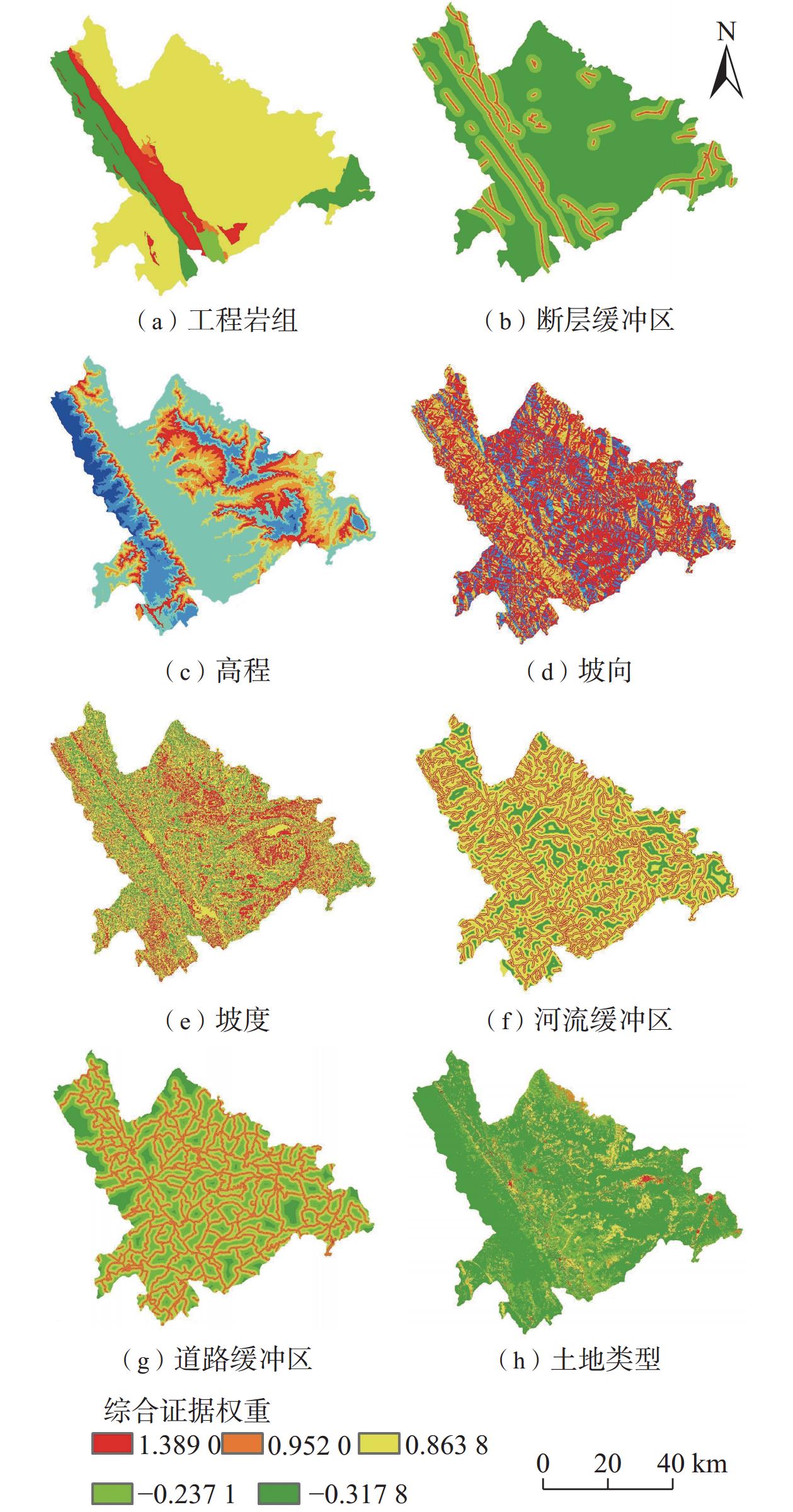
收集研究区地质灾害调查空间分布数据综合分析,借鉴前人研究成果结合自己实践经验,选择研究区地质灾害发育相关性较好的工程地质岩组、距断裂距离、地形高程、坡度、坡向、距水系距离、距道路距离和地类等8类评价因素。地质数据来自地质灾害调查与区划报告和图件[15], DEM出自ASF(12.5 m分辨率),地类数据从ESA获得(图1、表1)。
表 1 数据简介Table 1. Data overview introduction数据 灾点及
致灾要素类型 来源 地灾 地灾点 矢量点 地质灾害历年调查数据 地质 工程地质岩组 矢量面 地质灾害调查与区划报告[15] 距断裂距离 矢量线和缓冲区 地质灾害调查与区划报告[15] 地形地貌 高程 栅格 12.5 m DEM,https://asf.alaska.edu/ 坡度 栅格 根据DEM,应用ArcGIS提取 坡向 栅格 根据DEM,应用ArcGIS提取 道路 距道路距离 矢量线缓冲区 根据矢量线用ArcGIS制作 水系 距水系距离 矢量线缓冲区 根据矢量线用ArcGIS制作 土地类型 地类 栅格 ESA WorldCover 10 m 2020,
https://esa-worldcover.org/en1.2 地质灾害发育特征
新平县发育崩塌、滑坡、泥石流、地裂缝等地质灾害401处。其中,滑坡373个,崩塌4个,泥石流沟23条,地裂缝1条。滑坡分布最广,危害最为显著。小型滑坡325个,占87.13%;中型48个,占12.87%。崩塌以小型为主,小型泥石流20条[16],以小型为主。
选择指标“因子面积百分比A”“地灾数百分比B”和“比率(β=B/A)”表征地质灾害的空间分布特征、主控因素和成灾特征。β定义了地质灾害点在因素分级中相对于均匀分布的丰度,β>1表示相对丰度更高,β<1则相反。β>1的因素分级有(图2、表2):块状结构次硬岩组、松散岩组,距断裂距离小于
1000 m,高程800 ~1100 m、1300 ~2100 m段,坡度8°~25°,坡向北东、东、南东,距道路、河流0~500 m,建筑用地、裸地、耕地、灌木、草地。上述因素中地灾点分布较高,这些因素就是研究区地质灾害的敏感因子。![]() 图 2 各因素分级分区和地灾点数量相关性统计图Figure 2. Correlation statistical charts between factor grading zones and the number of geological hazard points表 2 因素证据权重计算结果表Table 2. Results of factor evidence weight calculation
图 2 各因素分级分区和地灾点数量相关性统计图Figure 2. Correlation statistical charts between factor grading zones and the number of geological hazard points表 2 因素证据权重计算结果表Table 2. Results of factor evidence weight calculation因
素因素分级 因素分级
面积百分
比(%)灾点数
百分比
(%)β W+ W− Wf 因
素因素分级 因素分级
面积百分
比(%)灾点数
百分比
(%)β W+ W− Wf 工
程
岩
组块状次硬岩组(A) 9.92 23.94 2.41 0.8824 − 0.1693 1.0517 坡
度/
(°)<8 10.63 10.47 0.98 − 0.0144 0.0017 − 0.0161 块状次软岩组(B) 13.32 3.49 0.26 − 1.3393 0.1075 − 1.4468 8~15 25.22 30.92 1.23 0.2041 − 0.0794 0.2835 层状软硬岩组(C) 74.45 69.83 0.94 − 0.0642 0.1665 0.2307 15~25 40.78 41.15 1.01 0.0089 − 0.0062 0.0151 层状软弱岩组(D) 1.42 1 0.70 − 0.3520 0.0043 − 0.3563 25~35 19.2 15.46 0.81 − 0.2170 0.0453 − 0.2623 松散岩组(E) 0.9 1.75 1.94 0.6658 − 0.0086 0.6744 35~45 3.83 2 0.52 − 0.6514 0.0189 − 0.6703 距
断
裂
距
离/
m0~50 1.01 2.99 2.96 1.0855 − 0.0202 1.1057 45~69 0.34 0 0.00 0.0000 0.0034 0.0034 50~100 1.01 1.25 1.24 0.2158 − 0.0024 0.2182 距
河
流
距
离/
m<50 6 6.8 1.13 0.1252 − 0.0086 0.1338 100~300 4.06 8.73 2.15 0.7659 − 0.0499 0.8158 50~100 5.91 7.05 1.19 0.1763 − 0.0122 0.1885 300~500 4.05 7.48 1.85 0.6157 − 0.0365 0.6522 100~300 22.56 29.47 1.31 0.2673 − 0.0935 0.3608 500~ 1000 9.83 10.47 1.07 0.0640 − 0.0072 0.0712 300~500 19.88 20.4 1.03 0.0260 − 0.0066 0.0326 > 1000 80.05 69.08 0.86 − 0.1475 0.4388 − 0.5863 500~ 1000 31.79 27.96 0.88 − 0.1284 0.0546 − 0.1830 高
程/
m<800 10.45 9.73 0.93 − 0.0717 0.0080 − 0.0797 > 1000 13.86 8.31 0.60 − 0.5113 0.0624 − 0.5737 800~ 1100 14.44 14.46 1.00 0.0020 − 0.0003 0.0023 距
道
路
距
离/
m<50 4.63 7.23 1.56 0.4464 − 0.0277 0.4741 1100 ~1300 10.94 7.98 0.73 − 0.3157 0.0327 − 0.3484 50~100 4.55 7.48 1.64 0.4968 − 0.0312 0.5280 1300 ~1500 13.62 17.71 1.30 0.2630 − 0.0486 0.3116 100~300 17.11 26.43 1.54 0.4354 − 0.1194 0.5548 1500 ~1700 14.53 18.7 1.29 0.2528 − 0.0501 0.3029 300~500 15.02 19.2 1.28 0.2459 − 0.0505 0.2964 1700 ~1900 11.14 18.95 1.70 0.5317 − 0.0921 0.6238 500~ 1000 28.64 25.19 0.88 − 0.1286 0.0473 − 0.1759 1900 ~2100 8.94 10.22 1.14 0.1340 − 0.0142 0.1482 > 1000 30.04 14.46 0.48 − 0.7315 0.2013 − 0.9328 2100 ~2500 11.43 2 0.17 − 1.7462 0.1013 − 1.8475 地
类林地(A) 70.37 47.38 0.67 − 0.3959 0.5752 0.9711 2500 ~3200 4.52 0.25 0.06 − 2.8976 0.0438 − 2.9414 灌木(B) 0.4 0.5 1.25 0.2097 − 0.0009 0.2106 坡
向北东(NE) 14.73 17.96 1.22 0.1979 − 0.0385 0.2364 草地(C) 13.55 14.46 1.07 0.0655 − 0.0107 0.0762 东(E) 13.72 20.95 1.53 0.4236 − 0.0876 0.5112 耕地(D) 11.34 26.18 2.31 0.8378 − 0.1834 1.0212 南东(SE) 12.99 14.21 1.09 0.0902 − 0.0142 0.1044 建筑(E) 0.64 2.49 3.89 1.3701 − 0.0189 1.3890 南(S) 12.73 12.22 0.96 − 0.0409 0.0058 − 0.0467 裸地(F) 3.47 8.98 2.59 0.9509 − 0.0588 1.0097 南西(SW) 10.93 7.23 0.66 − 0.4129 0.0407 − 0.4536 开阔水域(G) 0.22 0 0.00 0.0000 0.0000 0.0000 西(W) 10.43 6.48 0.62 − 0.4757 0.0431 − 0.5188 北西(NW) 11.34 8.23 0.73 − 0.3206 0.0345 − 0.3551 北(N) 13.14 12.72 0.97 − 0.0323 0.0048 − 0.0371 2. 计算方法
2.1 权重计算
根据式(1)(2)计算证据权重[17]:
$$ {W}^+=\mathrm{l}\mathrm{n}\left(\frac{n\left(B\cap D\right)}{n\left(B\cap D\right)+n\left(\bar{B}\cap D\right)}\left/\frac{n\left(B\cap \bar{D}\right)}{n\left(B\cap \bar{D}\right)+n\left(\bar{B}\cap \bar{D}\right)}\right.\right) $$ (1) $$ {W}^-=\mathrm{l}\mathrm{n}\left(\frac{n\left(\bar{B}\cap D\right)}{n\left(B\cap D\right)+n\left(\bar{B}\cap D\right)}\left/\frac{n\left(\bar{B}\cap \bar{D}\right)}{n\left(B\cap \bar{D}\right)+n\left(\bar{B}\cap \bar{D}\right)}\right.\right) $$ (2) 式中:$ {W}^{+} $、$ {W}^{-} $——正负权重因子,反映因子与地质灾 害发生的空间相关性大小/无量纲;
$ D $——有地质灾害分布的像素单元;
$ \bar{D} $——没有地质灾害分布的像素单元;
$ B $——因子像素单元;
$ \bar{B} $——非因子像素单元。
2.2 证据综合计算
进而计算每个像素单元k内发生地质灾害的后验概率:
$$ F=\mathrm{l}\mathrm{n}O\left(D|\sum _{i=1}^{n}{B}_{i}^{K\left(i\right)}\right)=\sum _{i=0}^{n}{W}_{i}^{K}+\mathrm{l}\mathrm{n}O\left(D\right) $$ (3) 式中:$O $——概率,$O(D)=D/(B-D) $;
$ {B}_{i} $——第$ i $个因子;
$ K\left(i\right) $——指示性参数,即第$ i $个因子内发生地质灾 害时取+,反之取−;
$ {W}_{i} $——第$ i $个因子的权重。
根据贝叶斯公式求得单元可能发生地质灾害的概率:
$$ P=O/(1+O)=\mathrm{e}\mathrm{x}\mathrm{p}\left(F\right)/\left(1+\mathrm{e}\mathrm{x}\mathrm{p}\left(F\right)\right) $$ (4) $ P $越大表示单元内发生地质灾害的概率越大。
3. 结果与讨论
3.1 证据权重计算结果和敏感性分析
(1)距断裂距离因素统计显示出较明显的距离效应,距断裂的距离与灾害发生的可能性呈反比关系,距断裂大于500 m的地区与地质灾害发生弱相关,而距断裂距离0~500 m易于地质灾害发生。工程地质岩组与灾害发生可能性呈非线性关系,工程地质岩组以块状结构次硬岩组、松散岩组利于地质灾害发生,正权重分别为0.882 4、0.665 8。
(2)坡度、坡向与灾害发生可能性呈波动关系,地形坡度8°~15°和15°~25°的山体斜坡较易于地质灾害发生,这些位置多为地形转换区域。坡向以东、北东较显著,这与新构造差异升降和河流侵蚀相关。在地形高程因素方面,
1300 ~1500 m、1500 ~1700 m和1700 ~1900 m段利于地质灾害发生,正权重分别为0.2630 、0.2528 和0.5317 ,这些区域人类活动较频繁,受人类干扰大。(3)距离公路河流的距离与灾害发生的可能性呈反比关系,随距主要公路、河流距离的增大地质灾害发生的数量减少,但0~300 m内灾害发生可能性大,主要是人类活动的影响随距离增大而减弱,所以地质灾害发生可能性降低。
(4)地类与灾害发生可能性呈波动关系,建筑、裸地、耕地有利于地质灾害发生,正权重分别为1.370 1、0.950 9、0.837 8,说明人类工程活动,开挖山体、弃土、破坏植被等对地质灾害的发生具有较大的影响。
(5)证据权相关性分析,因子证据权值正相关从大到小为:地类、距断裂距离、工程地质岩组、距道路距离、高程、坡向、距河流距离、坡度。
通过研究得出新平县的地质灾害易发性敏感因子为建筑用地、断层0~50 m、次硬岩组、道路50~100 m、高程
1700 ~1900 m、坡向东、距河流100~300 m、坡度8°~15°的正权重依次为1.3701 、1.0855 、0.8824 、0.4968 、0.5317 、0.4236 、0.2673 、0.2041 。上述因子是新平县地质灾害敏感因子,地质灾害防治中可以避让、控制相关因子,提高防灾工作的针对性。应用证据权法选取的敏感因子,在地质灾害易发性区划中效果好,可以为类似地质灾害敏感因子选择提供有益借鉴。根据敏感因子的研究选择,进行地质灾害易发性分区划定,为国土空间开发利用提供依据,合理利用空间资源;同时采取减少破坏山体、随意弃土、保护植被等针对性的防灾措施。
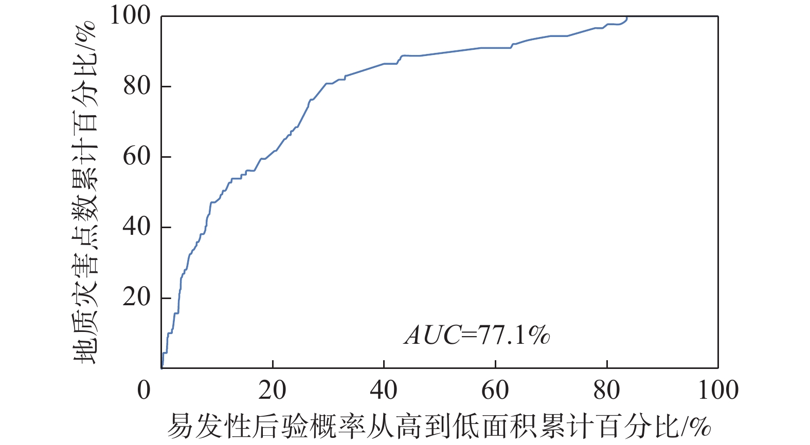
3.2 ROC曲线和AUC及易发性评价
采用接受者操作特性曲线(ROC)和曲线下与坐标轴围成的面积(AUC)[18 − 20]评估模型精度。本文模型的模型精度为77.1%,效果较好(图4)。
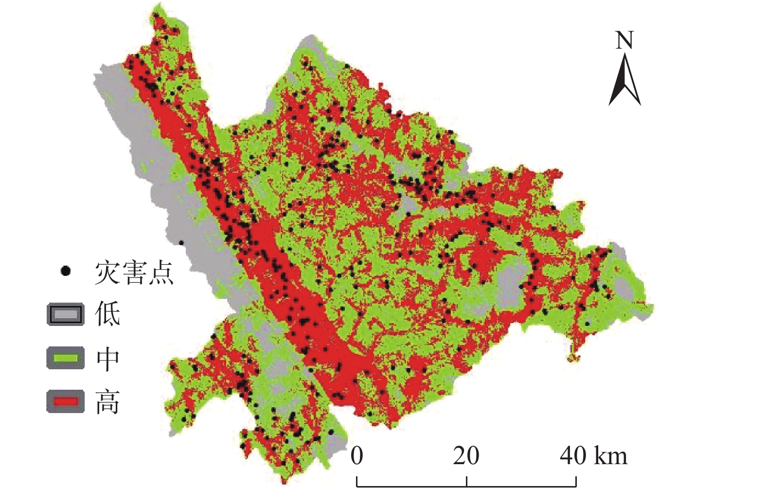
结合数值分级和灾点空间分布,进行易发性分区(表3、图5),其中高易发区
1532.94 km2(占总比36.11%),中易发区2119.07 km2(占比49.92%),74.06%和24.69%的地灾点落入高和中易发区,分区效果较好。表 3 地质灾害易发性分区表Table 3. Geological hazard susceptibility zoning table易发性分区 面积/km2 占总面积/% 灾点数 灾点百分比/% 高 1532.94 36.11 297 74.06 中 2119.07 49.92 99 24.69 低 592.72 13.97 5 1.25 易发性分类图显示西部的红河断裂带是地质灾害高易发区,元江西岸较东岸发育,西岸地质灾害最为集中。研究区地质灾害的发生受内外地质作用的多因素影响,受特定的构造背景和岩土体性质控制,同时土地利用对灾害发生影响也较大。研究区地质灾害高易发区范围较大,防治任务具有长期性和艰巨性。从国土空间开发利用分析,要主动避让地质灾害高发区,减少破坏植被和水土流失等措施。
3.3 问题讨论
研究区地形陡峻,地层岩性复杂,受河流侵蚀和人类工程活动干扰大,地质灾害易发。如何提高灾害防治能力和水平,特别是地质灾害敏感因子的选择和地质灾害易发性分区是关键性的工作。传统的区划办法主要是定性为主,定量不足,本文采用定量分析方法确定了敏感因子,计算了各因子的证据权重,依据权重数值完成易发性区划,研究结果符合新平县的地质灾害发育现状和特点。
但以往地质灾害调查工作侧重于人类活动区域,其他区域受调查技术手段限制,本文地质灾害数据可能会存在局部缺失,因而对研究造成一定影响。另外,本文研究结论受敏感因子选择、因子分级和灾点数据完整性、空间位置精度制约,研究结论还有不足,以后工作中还需加强因子优选、优化权重等研究,不断提高分区的科学性和实用性。
4. 结论
(1)根据证据权值正相关分析,灾害敏感性因子的相关性从大到小为:地类、距断裂距离、工程地质岩组、距道路距离、高程、坡向、距河流距离、坡度;确定新平县的地质灾害高易发性敏感的因子为建筑用地、距断层距离0~500 m、次硬岩组、距道路50~100 m、高程
1700 ~1900 m、坡向45°~90°、距河流100~300 m、坡度8°~15°,防灾工作中应该重点予以防范。(2)地质灾害易发性评价:根据敏感因子权重值划定了地质灾害易发性分区,有98.75%的灾点在高、中易发区内,易发性区划可以作为防灾的依据;新平县西部的红河断裂带两侧地质灾害易发性高,主要是红河断裂影响、地形坡度大、河流侵蚀的原因,应作为防灾重点。
(3)易发性精度评价:本文建立的证据权法模型的AUC为77.1%,评价结论有较好的理论支撑,拟合精度较好。
(4)本文采用定量方法,根据证据权值确定了敏感因子和地质灾害易发性区划,为灾害防治提供了支撑,在优化评价方法和数据驱动方面取得了进展,可为类似工作提供参考。
-
![]()
图 2 各因素分级分区和地灾点数量相关性统计图
Figure 2. Correlation statistical charts between factor grading zones and the number of geological hazard points
表 1 数据简介
Table 1 Data overview introduction
数据 灾点及
致灾要素类型 来源 地灾 地灾点 矢量点 地质灾害历年调查数据 地质 工程地质岩组 矢量面 地质灾害调查与区划报告[15] 距断裂距离 矢量线和缓冲区 地质灾害调查与区划报告[15] 地形地貌 高程 栅格 12.5 m DEM,https://asf.alaska.edu/ 坡度 栅格 根据DEM,应用ArcGIS提取 坡向 栅格 根据DEM,应用ArcGIS提取 道路 距道路距离 矢量线缓冲区 根据矢量线用ArcGIS制作 水系 距水系距离 矢量线缓冲区 根据矢量线用ArcGIS制作 土地类型 地类 栅格 ESA WorldCover 10 m 2020,
https://esa-worldcover.org/en 下载: 导出CSV
表 2 因素证据权重计算结果表
Table 2 Results of factor evidence weight calculation
因
素因素分级 因素分级
面积百分
比(%)灾点数
百分比
(%)β W+ W− Wf 因
素因素分级 因素分级
面积百分
比(%)灾点数
百分比
(%)β W+ W− Wf 工
程
岩
组块状次硬岩组(A) 9.92 23.94 2.41 0.8824 − 0.1693 1.0517 坡
度/
(°)<8 10.63 10.47 0.98 − 0.0144 0.0017 − 0.0161 块状次软岩组(B) 13.32 3.49 0.26 − 1.3393 0.1075 − 1.4468 8~15 25.22 30.92 1.23 0.2041 − 0.0794 0.2835 层状软硬岩组(C) 74.45 69.83 0.94 − 0.0642 0.1665 0.2307 15~25 40.78 41.15 1.01 0.0089 − 0.0062 0.0151 层状软弱岩组(D) 1.42 1 0.70 − 0.3520 0.0043 − 0.3563 25~35 19.2 15.46 0.81 − 0.2170 0.0453 − 0.2623 松散岩组(E) 0.9 1.75 1.94 0.6658 − 0.0086 0.6744 35~45 3.83 2 0.52 − 0.6514 0.0189 − 0.6703 距
断
裂
距
离/
m0~50 1.01 2.99 2.96 1.0855 − 0.0202 1.1057 45~69 0.34 0 0.00 0.0000 0.0034 0.0034 50~100 1.01 1.25 1.24 0.2158 − 0.0024 0.2182 距
河
流
距
离/
m<50 6 6.8 1.13 0.1252 − 0.0086 0.1338 100~300 4.06 8.73 2.15 0.7659 − 0.0499 0.8158 50~100 5.91 7.05 1.19 0.1763 − 0.0122 0.1885 300~500 4.05 7.48 1.85 0.6157 − 0.0365 0.6522 100~300 22.56 29.47 1.31 0.2673 − 0.0935 0.3608 500~ 1000 9.83 10.47 1.07 0.0640 − 0.0072 0.0712 300~500 19.88 20.4 1.03 0.0260 − 0.0066 0.0326 > 1000 80.05 69.08 0.86 − 0.1475 0.4388 − 0.5863 500~ 1000 31.79 27.96 0.88 − 0.1284 0.0546 − 0.1830 高
程/
m<800 10.45 9.73 0.93 − 0.0717 0.0080 − 0.0797 > 1000 13.86 8.31 0.60 − 0.5113 0.0624 − 0.5737 800~ 1100 14.44 14.46 1.00 0.0020 − 0.0003 0.0023 距
道
路
距
离/
m<50 4.63 7.23 1.56 0.4464 − 0.0277 0.4741 1100 ~1300 10.94 7.98 0.73 − 0.3157 0.0327 − 0.3484 50~100 4.55 7.48 1.64 0.4968 − 0.0312 0.5280 1300 ~1500 13.62 17.71 1.30 0.2630 − 0.0486 0.3116 100~300 17.11 26.43 1.54 0.4354 − 0.1194 0.5548 1500 ~1700 14.53 18.7 1.29 0.2528 − 0.0501 0.3029 300~500 15.02 19.2 1.28 0.2459 − 0.0505 0.2964 1700 ~1900 11.14 18.95 1.70 0.5317 − 0.0921 0.6238 500~ 1000 28.64 25.19 0.88 − 0.1286 0.0473 − 0.1759 1900 ~2100 8.94 10.22 1.14 0.1340 − 0.0142 0.1482 > 1000 30.04 14.46 0.48 − 0.7315 0.2013 − 0.9328 2100 ~2500 11.43 2 0.17 − 1.7462 0.1013 − 1.8475 地
类林地(A) 70.37 47.38 0.67 − 0.3959 0.5752 0.9711 2500 ~3200 4.52 0.25 0.06 − 2.8976 0.0438 − 2.9414 灌木(B) 0.4 0.5 1.25 0.2097 − 0.0009 0.2106 坡
向北东(NE) 14.73 17.96 1.22 0.1979 − 0.0385 0.2364 草地(C) 13.55 14.46 1.07 0.0655 − 0.0107 0.0762 东(E) 13.72 20.95 1.53 0.4236 − 0.0876 0.5112 耕地(D) 11.34 26.18 2.31 0.8378 − 0.1834 1.0212 南东(SE) 12.99 14.21 1.09 0.0902 − 0.0142 0.1044 建筑(E) 0.64 2.49 3.89 1.3701 − 0.0189 1.3890 南(S) 12.73 12.22 0.96 − 0.0409 0.0058 − 0.0467 裸地(F) 3.47 8.98 2.59 0.9509 − 0.0588 1.0097 南西(SW) 10.93 7.23 0.66 − 0.4129 0.0407 − 0.4536 开阔水域(G) 0.22 0 0.00 0.0000 0.0000 0.0000 西(W) 10.43 6.48 0.62 − 0.4757 0.0431 − 0.5188 北西(NW) 11.34 8.23 0.73 − 0.3206 0.0345 − 0.3551 北(N) 13.14 12.72 0.97 − 0.0323 0.0048 − 0.0371
下载: 导出CSV
表 3 地质灾害易发性分区表
Table 3 Geological hazard susceptibility zoning table
易发性分区 面积/km2 占总面积/% 灾点数 灾点百分比/% 高 1532.94 36.11 297 74.06 中 2119.07 49.92 99 24.69 低 592.72 13.97 5 1.25
下载: 导出CSV
-
[1] 曹慧,何政伟,陈亮. 云南某县地质灾害与土地利用类型相关性分析[J]. 测绘科学,2007,32(2):114 − 115. [CAO Hui,HE Zhengwei,CHEN Liang. The relevancy analysis of geological hazard and land-use types in some County of Yunnan Province[J]. Science of Surveying and Mapping,2007,32(2):114 − 115. (in Chinese with English abstract)] DOI: 10.3771/j.issn.1009-2307.2007.02.041 CAO Hui, HE Zhengwei, CHEN Liang. The relevancy analysis of geological hazard and land-use types in some County of Yunnan Province[J]. Science of Surveying and Mapping, 2007, 32(2): 114 − 115. (in Chinese with English abstract) DOI: 10.3771/j.issn.1009-2307.2007.02.041
[2] 仲冰. 云南省新平县滑坡灾害风险评估研究[D]. 北京:中国地质大学(北京),2008. [ZHONG Bing. Study on risk assessment of landslide disaster in Xinping County,Yunnan Province[D]. Beijing:China University of Geosciences,2008. (in Chinese with English abstract)] ZHONG Bing. Study on risk assessment of landslide disaster in Xinping County, Yunnan Province[D]. Beijing: China University of Geosciences, 2008. (in Chinese with English abstract)
[3] 徐为. 基于区域风险评估的降雨型地质灾害监测预警方法研究——以云南哀牢山新平县为例[D]. 北京:中国科学院大学,2013. [XU Wei. Study on monitoring and early warning method of rainfall geological disasters based on regional risk assessment:A case study of Xinping County,Ailao mountain,Yunnan Province[D]. Beijing:University of Chinese Academy of Sciences,2013. (in Chinese with English abstract)] XU Wei. Study on monitoring and early warning method of rainfall geological disasters based on regional risk assessment: A case study of Xinping County, Ailao mountain, Yunnan Province[D]. Beijing: University of Chinese Academy of Sciences, 2013. (in Chinese with English abstract)
[4] 康杰. 云南新平县地质灾害形成机制及易发性分区研究[D]. 昆明:昆明理工大学,2021. [KANG Jie. Study on formation mechanism and susceptibility zoning of geological disasters in Xinping County,Yunnan Province[D]. Kunming:Kunming University of Science and Technology,2021. (in Chinese with English abstract)] KANG Jie. Study on formation mechanism and susceptibility zoning of geological disasters in Xinping County, Yunnan Province[D]. Kunming: Kunming University of Science and Technology, 2021. (in Chinese with English abstract)
[5] 金德山. 县域地质灾害调查是构筑地灾防治工作体系的基石——以云南省为例[J]. 中国地质灾害与防治学报,2005,16(3):28 − 30. [JIN Deshan. County territory investigation of geo-disaster is the footstone of geo-disaster control system:Taking the Yunnan Province as a example[J]. The Chinese Journal of Geological Hazard and Control,2005,16(3):28 − 30. (in Chinese with English abstract)] DOI: 10.3969/j.issn.1003-8035.2005.03.007 JIN Deshan. County territory investigation of geo-disaster is the footstone of geo-disaster control system: Taking the Yunnan Province as a example[J]. The Chinese Journal of Geological Hazard and Control, 2005, 16(3): 28 − 30. (in Chinese with English abstract) DOI: 10.3969/j.issn.1003-8035.2005.03.007
[6] BONHAM-CARTER G,AGTERBERG F,WRIGHT D. Weights of evidence modelling:A new approach to mapping mineral potentia[J]. Paper - Geological Survey of Canada,1990:171 − 183.
[7] AGTERBERG F P. Combining indicator patterns in weights of evidence modeling for resource evaluation[J]. Nonrenewable Resources,1992,1(1):39 − 50. DOI: 10.1007/BF01782111
[8] AGTERBERG F P,BONHARN-CARTER G F. Weights of evidence modeling and weighted logistic regression for mineral potential mapping[M]//Computers in Geology - 25 Years of Progress. Oxford:Oxford University Press,1994.
[9] LUSTED LEE B. An introduction to medical decision making[J]. American Journal of Physical Medicine & Rehabilitation,1970,49(5):322.
[10] SPIEGELHALTER D J,KNILL-JONES R P. Statistical and knowledge-based approaches to clinical decision-support systems,with an application in gastroenterology[J]. Journal of the Royal Statistical Society Series A (General),1984,147(1):35. DOI: 10.2307/2981737
[11] 闫怡秋,杨志华,张绪教,等. 基于加权证据权模型的青藏高原东部巴塘断裂带滑坡易发性评价[J]. 现代地质,2021,35(1):26 − 37. [YAN Yiqiu,YANG Zhihua,ZHANG Xujiao,et al. Landslide susceptibility assessment based on weight-of-evidence modeling of the Batang fault zone,eastern Tibetan Plateau[J]. Geoscience,2021,35(1):26 − 37. (in Chinese with English abstract)] DOI: 10.19657/j.geoscience.1000-8527.2020.091 YAN Yiqiu, YANG Zhihua, ZHANG Xujiao, et al. Landslide susceptibility assessment based on weight-of-evidence modeling of the Batang fault zone, eastern Tibetan Plateau[J]. Geoscience, 2021, 35(1): 26 − 37. (in Chinese with English abstract) DOI: 10.19657/j.geoscience.1000-8527.2020.091
[12] 刘璐瑶,高惠瑛. 基于证据权与Logistic回归模型耦合的滑坡易发性评价[J]. 工程地质学报,2023,31(1):165 − 175. [LIU Luyao,GAO Huiying. Landslide susceptibility evaluation based on the coupling of evidence weight and Logistic regression model[J]. Journal of Engineering Geology,2023,31(1):165 − 175. (in Chinese with English abstract)] DOI: 10.13544/j.cnki.jeg.2020-482 LIU Luyao, GAO Huiying. Landslide susceptibility evaluation based on the coupling of evidence weight and Logistic regression model[J]. Journal of Engineering Geology, 2023, 31(1): 165 − 175. (in Chinese with English abstract) DOI: 10.13544/j.cnki.jeg.2020-482
[13] 黄发明,石雨,欧阳慰平,等. 基于证据权和卡方自动交互检测决策树的滑坡易发性预测[J]. 土木与环境工程学报(中英文),2022,44(5):16 − 28. [HUANG Faming,SHI Yu,OUYANG Weiping,et al. Landslide susceptibility prediction modeling based on weight of evidence and Chi-square automatic interactive detection decision tree[J]. Journal of Civil and Environmental Engineering,2022,44(5):16 − 28. (in Chinese with English abstract)] HUANG Faming, SHI Yu, OUYANG Weiping, et al. Landslide susceptibility prediction modeling based on weight of evidence and Chi-square automatic interactive detection decision tree[J]. Journal of Civil and Environmental Engineering, 2022, 44(5): 16 − 28. (in Chinese with English abstract)
[14] 孙滨,祝传兵,康晓波,等. 基于信息量模型的云南东川泥石流易发性评价[J]. 中国地质灾害与防治学报,2022,33(5):119 − 127. [SUN Bin,ZHU Chuanbing,KANG Xiaobo,et al. Susceptibility assessment of debris flows based on information model in Dongchuan,Yunnan Province[J]. The Chinese Journal of Geological Hazard and Control,2022,33(5):119 − 127. (in Chinese with English abstract)] SUN Bin, ZHU Chuanbing, KANG Xiaobo, et al. Susceptibility assessment of debris flows based on information model in Dongchuan, Yunnan Province[J]. The Chinese Journal of Geological Hazard and Control, 2022, 33(5): 119 − 127. (in Chinese with English abstract)
[15] 云南地质环境监测总站,云南地质工程第二勘察院. 云南省新平县地质灾害调查与区划报告[R]. 2003. [Yunnan Geological Environment Monitoring Station,The Second Survey Institute of Geological engineering. Geological hazards survey and division in Xinping County,Yunnan Province[R]. 2003. (in Chinese)] Yunnan Geological Environment Monitoring Station, The Second Survey Institute of Geological engineering. Geological hazards survey and division in Xinping County, Yunnan Province[R]. 2003. (in Chinese)
[16] 尹洪峰,谢博,赵体,等. 云南省新平县地质灾害发育特征及防治对策研究[J]. 长春工程学院学报(自然科学版),2006,7(2):54 − 56. [YIN Hongfeng,XIEBo,ZHAOTi,et al. Research on developing characteristics and preventing measures of geology disaster in Xinping Country of Yunnan Province[J]. Journal of Changchun Institute of Technology (Natural Sciences Edition),2006,7(2):54 − 56. (in Chinese with English abstract)] DOI: 10.3969/j.issn.1009-8984.2006.02.018 YIN Hongfeng, XIEBo, ZHAOTi, et al. Research on developing characteristics and preventing measures of geology disaster in Xinping Country of Yunnan Province[J]. Journal of Changchun Institute of Technology (Natural Sciences Edition), 2006, 7(2): 54 − 56. (in Chinese with English abstract) DOI: 10.3969/j.issn.1009-8984.2006.02.018
[17] 自然资源部.地质灾害风险调查评价技术要求(1∶ 50000 )::FXPC/ZRZY B-01[S]. 2020. [Ministry of Natural Resources of the People's Republic of China.Technical requirements of survey and evaluation for geohazard risk (1: 50 000):FXPC/ZRZY B-01[S]. 2020. (in Chinese)]Ministry of Natural Resources of the People's Republic of China.Technical requirements of survey and evaluation for geohazard risk (1: 50 000):FXPC/ZRZY B-01[S]. 2020. (in Chinese)
[18] HOYER A,KUSS O. Meta-analysis of full ROC curves with flexible parametric distributions of diagnostic test values[J]. Research Synthesis Methods,2020,11(2):301 − 313. DOI: 10.1002/jrsm.1395
[19] WALKER S P. The ROC curve redefined:Optimizing sensitivity (and specificity) to the lived reality of cancer[J]. New England Journal of Medicine,2019,380(17):1594 − 1595. DOI: 10.1056/NEJMp1814951
[20] OMAR L,IVRISSIMTZIS I. Using theoretical ROC curves for analysing machine learning binary classifiers[J]. Pattern Recognition Letters,2019,128:447 − 451. DOI: 10.1016/j.patrec.2019.10.004
-
期刊类型引用(4)
1. 李朝辉,张柯宏. 藏东南某滑坡成因分析及稳定性评价. 铁道勘察. 2025(01): 13-19 .  百度学术
百度学术
2. 李骏,李状,苗晋杰,刘宏伟,刘笑,高伊航. 山西省阳城县北窑村滑坡特征及成因分析. 华北地质. 2025(01): 95-102 . 百度学术
3. 侯艳权,王义春,李岑,佘燕飞,修唯,掌旭. 极端天气多源融合预警方法研究. 微型电脑应用. 2024(08): 73-76 . 百度学术
4. 张昊天,王新刚,罗力,王友林,郭倩怡,薛晨. 秦巴山区典型碎石土抗剪强度变化规律及其在堆积层滑坡机理分析中的应用. 中国地质灾害与防治学报. 2024(05): 50-58 . 本站查看
其他类型引用(0)


计量
- 文章访问数: 271
- HTML全文浏览量: 85
- PDF下载量: 130
- 被引次数: 4
 邮件订阅
邮件订阅 RSS
RSS