

Analysis on characteristics and reactivation mechanism of secondary landslides in the front part of the Xijitan giant landslide, Guide Basin
-
摘要:
黄河上游地区位于构造活动剧烈的青藏高原东北缘,其复杂的地质条件孕育了大量的滑坡、崩塌等地质灾害。文章以青海省贵德县尕让乡江拉新村北席芨滩巨型滑坡前缘次级滑坡为研究对象,采用无人机航测、InSAR地表位移监测、现场调查和室内力学试验等手段,详细分析了滑坡的地质背景、发育特征和复活机制。现场调查发现:滑坡区岩体结构破碎疏松,主要出露地层岩性为新近系泥岩和全新统坡积物;次级滑坡后缘发育多条大型裂缝和张拉带,地表变形明显,处于蠕滑变形阶段;密集发育的结构面对次级滑坡的复活起到控制作用,集中降雨导致的泥岩软化是诱发滑坡复活的关键因素,二者的互馈作用会持续降低滑坡区岩体的完整度和强度,导致次级滑坡的变形复活。研究结果可为黄河上游地区防灾减灾工作提供理论基础。
Abstract:The upper reaches of the Yellow River, located on the northeastern edge of the tectonically active Qinghai Tibet Plateau, are characterized by complex geological conditions that have led to a high incidence of geological disasters such as landslides and collapses. This study focuses on the secondary landslide at the front part of the Xijitan landslide on the north side in Jiangla Village, Garang Township, Guide County, Qinghai Province. Using methods including unmanned aerial vehicle surveying, InSAR surface displacement monitoring, and on-site investigation methods, a detailed analysis of the geological environmental conditions, development characteristics, and reactivation mechanism of the landslide are conducted. On-site investigation results indicate that the rock mass structure in the landslide area is fragmented, with concentrated rainfall. The main exposed strata are Neogene mudstone and Holocene slope deposits. Multiple large cracks and tension bands are developed at the rear edge of the landslide, and the surface deformation is obvious, in the stage of creep deformation. Analysis of the mechanism of landslide reactivation reveals that densely developed structures play a controlling role in the reactivation of secondary landslides, and the softening of mudstone caused by concentrated rainfall is a key factor in inducing landslide reactivation. The interaction between two factors continuously reduce the integrity and strength of the rock mass, leading to the deformation and reactivation of secondary landslides. The research results aim to provide a theoretical basis for disaster prevention and reduction work in the upper reaches of the Yellow River.
-
0. 引言
黄河上游地区位于青藏高原与黄土高原的交接地带,地质构造比较复杂[1],发育了多个巨型、大型滑坡[2 − 3],仅拉干峡-寺沟峡段就发育特大型滑坡116处[4]。这些滑坡具有“突发性强、落差大、动力强、规模大”的特点,并制约着黄河流域生态保护和高质量发展,是当前国内外地质工作研究的重点地区之一[5 − 6]。
在滑坡发育过程中,构造应力的作用至关重要,构造应力不仅能导致岩层的破裂和变形,还能为滑坡的发生提供潜在的滑动面[7 − 8]。位于汶川强震区的新磨滑坡和唐家湾滑坡是典型的受构造动力影响的特大型高位远程滑坡,滑体自高陡斜坡上部位置剪出并形成凌空加速坠落,具有撞击粉碎效应和动力侵蚀效应,导致大量人员伤亡[9 − 10];白龙江流域的构造活动促进了岩体结构面的发育,降低了岩体的强度,最终形成结构面控制的滑坡群[11];黄河上游地区所处的青藏高原东北缘板块现今仍在快速隆升[12],板块活动过程中,强烈的地应力使区域内发育多条大型断裂带,断裂活动会进一步并促使滑坡发育[13],例如,构造断裂的强烈挤压为阿什贡滑坡带提供了发育条件[14];戈龙布早期滑坡在尖东断裂、马儿断裂活动的作用下,导致锁固段破裂,形成巨型错落式快速旋转滑移[15];塔吉克斯坦Ms7.2级地震扰动区存在3个显著的升降变形区,且同震滑坡在主要沿地震断裂呈带状展布[16]。
水分入渗是诱发滑坡的关键因素,大量降雨会通过地表径流和渗透作用进入坡体内部[17],在水-岩(土)作用下[18],岩土体剪切强度显著降低并促进滑坡变形失稳[19 − 22]。黄河上游地区的康扬古滑坡在河流侧蚀和降水入渗作用下变形复活[23];中堡滑坡在连续强降雨作用下,滑体含水量增加,岩土体在重力作用下沿滑面滑动,造成1.3×10⁵ m3的滑体迅速滑入峡谷,引发人员伤亡和财产损失[24];在短时集中降雨作用影响下,纳古呢沟内滑坡-泥石流-溃决型洪水泥石流灾害链往复进行[25]。对于土质或软岩滑坡,灌溉和不合理的土地利用,改变了其水文环境,也会导致岩土体的软化和滑坡的发生[26];尖扎盆地寺门村滑坡是水分入渗促进滑坡发育的典型案例[27];数十年的塬上大面积灌溉,致使黑方台地下水位不断提升,迄今为止已有200余起滑坡发生[28]。
贵德盆地是黄河上游地区滑坡发育较密集的区域[4],盆地四周被断裂所围限,西至龙羊峡和瓦里贡山,东至松巴峡和扎马杂日山,北部为拉脊山,南侧为巴吉山,见图1[29]。贵德盆地中心发育的席芨滩巨型滑坡在历史时期曾发生过失稳滑动,导致黄河改道并威胁到当地的生产生活安全[30]。目前,席芨滩巨型滑坡前缘局部复活,发育形成了两处次级大型滑坡,本文采用无人机航测、InSAR动态观测和实地调查等手段,分析了席芨滩滑坡前缘次级滑坡的发育特征及复活机理,为黄河上游滑坡灾害链防灾减灾提供科学依据。
1. 地质背景及滑坡概况
1.1 区域地质背景
滑坡所处的贵德盆地位于青藏高原东北缘,这里构造运动剧烈,地表被强烈侵蚀,岩层风化破碎[31]。在新构造运动期间大面积间歇性抬升[15],致使黄河两岸砾石层抬升至侵蚀基准面以上数十至数百米[32 − 33],为滑坡发育提供了临空条件。贵德盆地黄河北岸出露地层主要为贵德组地层(图1),其下部为浅黄色砂岩、泥岩和砂质泥岩,中部和上部为黄色厚层状泥岩和砂岩,贵德组上覆有全新统残坡积地层[34],加之研究区经历了多期滑坡失稳破坏,导致区域内岩土体结构面密集发育,这些破碎的软岩为滑坡的发育提供了物质基础。
贵德盆地气候类型为高山高原气候,本文采用国家地球系统科学数据中心的降水量数据集(分辨率1 km)分析滑坡区气候特征,统计结果表明,贵德盆地年均降水量约423~576 mm,最大年降水量579 mm[35]。区域内降雨集中,一般5—9月降水量约为全年的85%。
1.2 滑坡概况
席芨滩巨型滑坡位于贵德盆地中部黄河北岸,通过野外实地调查,遥感分析和整理前人研究资料可以判断席芨滩巨型滑坡在主要分为4个发育期次,其中,Ⅰ期滑坡滑距短,宽度大,滑坡后壁高差约300 m,滑坡后壁只有西侧部分得以保留,东侧滑体被之后发生的席芨滩Ⅱ期滑坡的滑体掩埋和覆盖;Ⅱ期滑坡是现在席芨滩滑坡主体部分,现场调查和卫星影像发现,滑坡南侧沿山脚流动的黄河古河道被废弃,滑体将黄河河道向东南方向推移;Ⅲ期滑坡是Ⅱ期滑坡滑体解体后形成的滑坡,由于Ⅰ期滑坡高差大,Ⅱ期滑坡掩盖Ⅰ期滑坡后,仍滑体上保留了一个明显的陡坎,为Ⅲ期滑坡的发育提供了临空条件,历史资料记载,1872年Ⅲ期滑坡曾发生大规模失稳破坏;Ⅳ期滑坡是Ⅱ、Ⅲ期滑体前缘与黄河河漫滩交界的陡坎处的若干个现代小型滑坡崩塌[30](图2)。
![]() 图 2 席芨滩滑坡概况图注:a为席芨滩滑坡位置图;b为席芨滩滑坡分期图;c为席芨滩滑坡剖面图[30];d为次级滑坡航拍图;e、f、g为席芨滩滑坡分期发育特征。Figure 2. Overview of the location of Xijitan landslide
图 2 席芨滩滑坡概况图注:a为席芨滩滑坡位置图;b为席芨滩滑坡分期图;c为席芨滩滑坡剖面图[30];d为次级滑坡航拍图;e、f、g为席芨滩滑坡分期发育特征。Figure 2. Overview of the location of Xijitan landslide本文研究对象位于席芨滩巨型滑坡前缘,贵德县江拉新村西北侧700 m 处,为席芨滩Ⅱ、Ⅲ期滑坡滑体再度解体后,发育的两处次级滑坡(图3—4)(为方便叙述,下文将席芨滩前缘的西侧次级滑坡称为1#滑坡,将东侧次级滑坡称为2#滑坡),次级滑坡后缘为席芨滩Ⅱ期滑坡陡坎,西侧为走向 200°~210°的条形山脊,山顶高程约2 543 m,东临黑峡沟,沟的走向为182°~190°,沟底高程约为2 197 m,前缘为黄河阶地,高程约
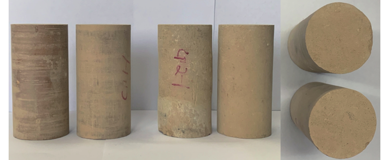
2199 m。InSAR监测结果显示滑坡变形量逐年稳定增加,现场调查发现滑坡岩土体结构面发育,次级滑坡后缘裂缝密集,推断滑坡目前处于变形复活阶段。为探究滑坡区泥岩基本物理性质和物质构成,于2#滑坡后缘取原状贵德组泥岩试样,取样过程需避开外部的风化岩石层,取内部的结构发育较少的泥岩块体,为减少试样水分的蒸发,用多层黑色塑料膜和胶带将岩块完全密封。所采集的各地层岩样置于垫有塑料泡沫的木制箱中,随后平稳地运送到实验室进行取芯。使用岩石取芯钻机取50 mm×100 mm的岩芯(图5)用于开展相关试验。
采用烘干法测得泥岩天然密度为2.35 g/cm3,干密度为2.21 g/cm3,天然含水率为5.44%,饱和含水率为15.43%;采用X射线衍射试验测定泥岩矿物组成,泥岩主要矿物为石英,含量为34.4%,方解石含量为18.4%,白云母含量为14.6%,钠长石含量为9.5%,泥岩黏土矿物为伊利石、高岭石和蒙脱石,含量分别为8.6%、4.9%和0.5%,黏土矿物总含量为23.1%,亲水矿物总含量为54.3%。以上试验结果表明滑坡区贵德组泥岩为硅质泥岩,且泥岩黏土矿物含量高,吸水性强。
2. 滑坡发育特征
2.1 滑坡形态特征
1#、2#滑坡平面形态特征明显。根据卫星遥感影像、无人机航测数据和现场调查,1#滑坡后缘高程
2513 m,前缘高程2216 m,相对高差297 m。滑体长期被流水侵蚀,发育两条大型水蚀冲沟,冲沟两侧产生大量坡体临空面,在重力和自然界外营力作用下附近土体卸荷,导致1#滑坡多处解体,坡体表面发生溃滑。滑坡纵长约963~1265 m,横宽约756~890 m,空间面积约8.762×10⁵ m2,滑体厚度约25~70 m。冲沟西侧滑体主滑方向约144°,冲沟东侧滑体主滑方向约160°,斜坡内发育多个小型陡坎,整体坡度21°~26°(图6)。2#滑坡后缘高程
2513 m,前缘黄河阶地高程2194 m,相对高差319 m。形态近圈椅状,滑坡纵长约1101 ~1361 m,横宽约779~1065 m,空间面积约1.0984 ×10⁶ m2,滑体厚度约30~65 m。2#的滑坡的主滑方向为153°,滑坡后缘较陡前缘较缓,坡度为22°~30°,滑坡后缘最陡处约35°(图6)。2#滑坡体分为两级平台,一级平台位于滑坡前缘,高程2 287 m,宽约185 m,坡度16°,二级平台靠近滑坡后缘,平台上拉张裂缝发育,高程2 287 m,宽约203 m,坡度17°(图7)。受流水侵蚀的影响,坡面发育多条大型冲沟。滑坡后缘有多处因流水侵蚀和拉张应力作用下而形成的次级小型滑坡。
2.2 滑坡变形特征
本文采用野外调查和SBAS-InSAR技术对滑坡进行了调查分析,研究了滑坡的变形特征。野外调查发现,1#、2#滑坡发育多条裂缝,尤其在滑坡后缘,形成典型的拉张裂缝(A)和拉张带(B)。裂缝( A) 位于1#滑坡后缘,距离滑坡后缘约100 m,展布方向 301°,东侧裂缝地表扩张度20~25 cm(图8a) ,西侧裂缝呈串珠状(图8b),裂缝长度约35 m。拉张带(B)位于2#滑坡后缘,距离滑坡后缘约85 m,展布方向254°,拉张带带宽5 m,单条裂缝地表扩张度25~35 cm(图8d) ,裂缝总长约220 m。
SBAS-InSAR(数据来源:欧空局2018—2021年Sentinel-1)数据显示,在竖直方向,1#滑坡后缘部分最大形变速率为91 mm/a,2#滑坡后缘部分最大形变速率为74 mm/a(以竖直向上为正方向,图9a);在水平方向,1#滑坡后缘部分最大形变速率为116.3 mm/a,2#滑坡后缘部分最大形变速率为104.0 mm/a,以150°方位为正方向,见图9(b)。野外调查与InSAR结果均表明1#、2#滑坡的后缘变形量及活动性较强,推测该处滑体可能处于蠕滑变形阶段。
3. 滑坡形成机理分析
通过调查研究,本文认为席芨滩巨型滑坡前缘次级滑坡实质是席芨滩古滑坡前缘局部复活的表现,其复活机理与岩体结构的组成和集中降水导致的泥岩软化关系密切。岩体结构是促成席芨滩古滑坡局部复活的内因,对古滑坡复活起到控制性作用;集中降水是古滑坡复活的外在因素,通过直接或间接的影响进而诱发古滑坡复活。下面本文将从这两个方面对该处滑坡复活机理进行分析。
3.1 岩体结构与滑坡
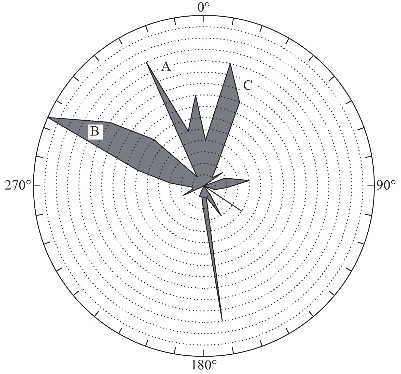
岩体结构是控制坡体稳定性的关键因素,结构面越发育,岩体结构越松散,进而导致坡体稳定性越差。席芨滩古滑坡发育演化过程中,其滑体的原始应力状态发生了变化,致使形成滑体的岩体由整体状结构演变成为被多组结构面切割的块状结构。本文对古滑坡前缘局部复活形成的1#、2#滑坡范围内的岩体结构展开了调查和统计,发现滑坡区域有由3组优势节理控制的结构面,产状分别为(A)335°~345°∠33°~50°、(B)290°~300°∠70°~85°和(C)15°~25°∠70°~80°(图10),致使滑坡区岩体的完整程度为破碎—较破碎[36]。
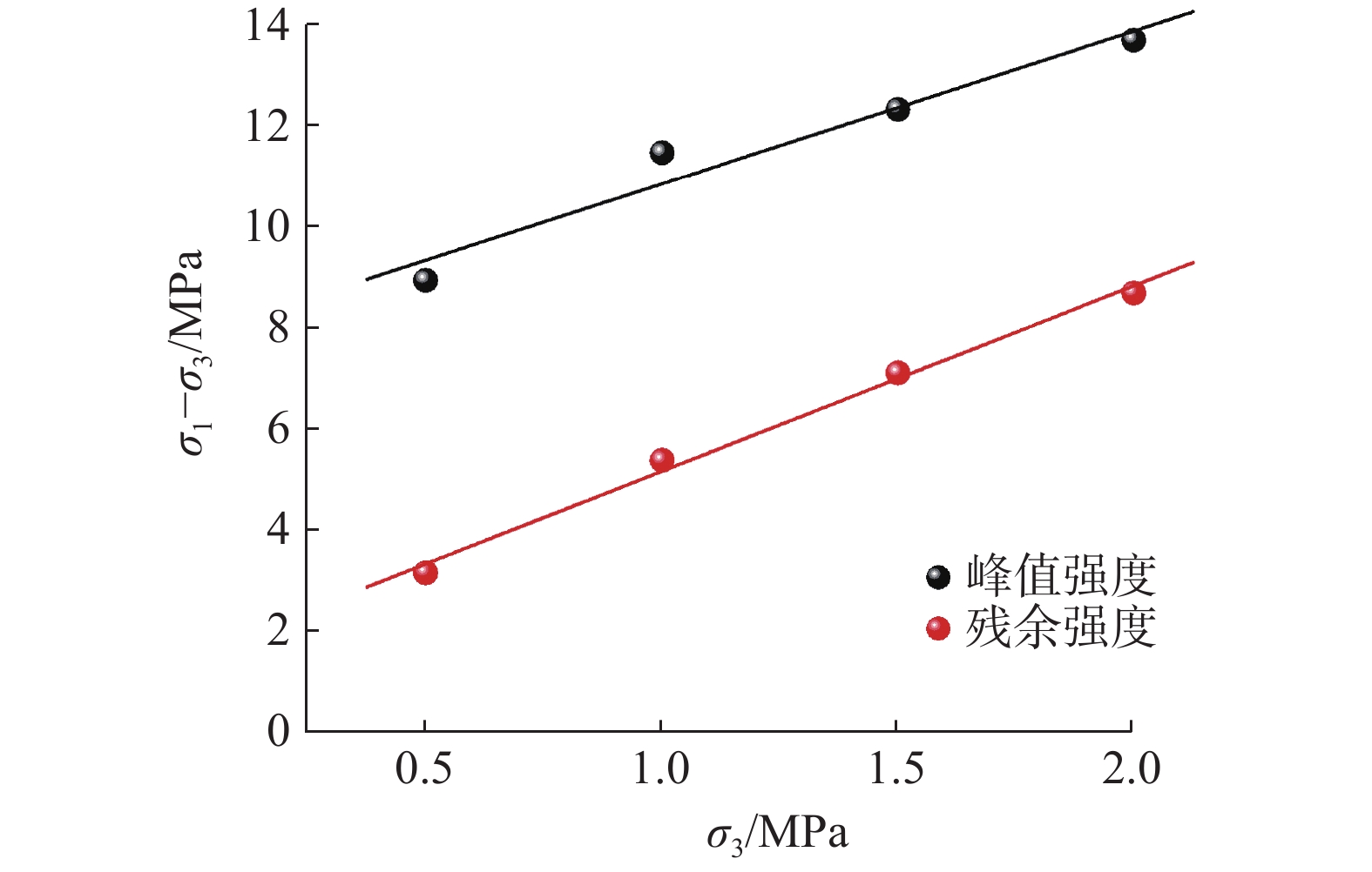
泥岩结构面对次级滑坡复活的控制作用主要体现在以下四方面,其一,发育的结构面使岩体的各向异性增强,整体均匀性减弱,导致岩体强度远低于完整岩体[28]。通过设置围压分别为0.5,1.0,1.5,2.0 MPa的原状三轴剪切试验,测试天然含水率下滑坡泥岩力学性质,并采用残余强度(岩石峰后应力-应变关系曲线拐点处对应的强度)来预估破碎岩的强度。整理泥岩的峰值强度和残余强度随围压的变化规律,可以观察到良好的线性关系,故采用最小二乘法对数据点进行线性拟合(图11),拟合方程为:
![]() 图 11 泥岩峰值强度、残余强度与围压的关系Figure 11. The relationship between peak strength, residual strength, and confining pressure of mudstone
图 11 泥岩峰值强度、残余强度与围压的关系Figure 11. The relationship between peak strength, residual strength, and confining pressure of mudstone(1) 式中:q——强度;
σ3——围压;
a、b——拟合参数。
通过分析峰值强度、残余强度与围压关系图,可以发现泥岩试样峰值强度曲线的截距(拟合参数b)远大于残余强度,既泥岩在达到峰值强度时具有较大的黏结强度,而在残余强度状态黏结强度大幅度折减,说明在峰后变形阶段随着泥岩试样内部萌生的微裂纹充分发育,由于岩石破坏起主要抑制作用的是黏结强度,密集发育的结构会进一步损伤岩体,并导致黏结强度明显下降(表1)。这表明,密集发育的结构面通过直接降低泥岩的黏结强度,导致滑坡抗滑力降低,并促进滑坡变形复活。
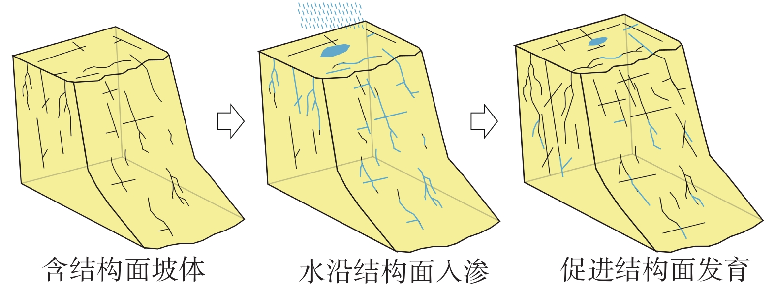
表 1 泥岩峰值强度和残余强度拟合参数Table 1. Fitting parameters for peak strength and residual strength of mudstonea b R2 峰值强度 3.028 ± 0.479 7.835 ± 0.656 0.9523 残余强度 3.663 ± 0.209 1.517 ± 0.287 0.9935 其二,泥岩结构面是地表水入渗的优势渗流通道,是地表外营力对岩体改造的重要促进因素,这导致含结构面泥岩的裂隙发展速度快于泥岩岩块,这种现象会进一步降低岩体强度(图12)。其三,滑坡区内有多组走向与滑坡主滑方向垂直的结构面,在良好的临空条件下,滑坡边界的岩体会沿结构面剥离原岩,导致滑坡周界进一步扩张发育(图3d、图3g)。其四,滑坡内发育的节理倾角陡立,而研究区内泥岩岩体内摩擦角为32°~44°,结构面倾角大于或近似等于岩体内摩擦角,这些顺层倾角的结构面会大幅降低滑坡的抗滑力,形成潜在滑移面,随着结构面进一步发育贯通,滑坡形成潜在滑移面时需要剪断的结构体抗体就越少,滑坡的稳定性随之降低。调查发现1#、2#滑坡后缘泥岩结构面密集,滑坡后缘可见多处泥岩破碎带,破碎带内岩体块度小于0.5 m(图13)。对于滑坡整体而言,结构面发育的部分易发生变形和局部失稳,因此,监测发现滑坡变形速率较高的区域集中于后缘(图9)。综上所述,岩体结构面特征对滑坡复活过程起到了控制性作用。
![]() 图 12 优势入渗促进结构面发育机制图Figure 12. Mechanism diagram of dominant infiltration-promoted structural plane development
图 12 优势入渗促进结构面发育机制图Figure 12. Mechanism diagram of dominant infiltration-promoted structural plane development3.2 降雨与滑坡
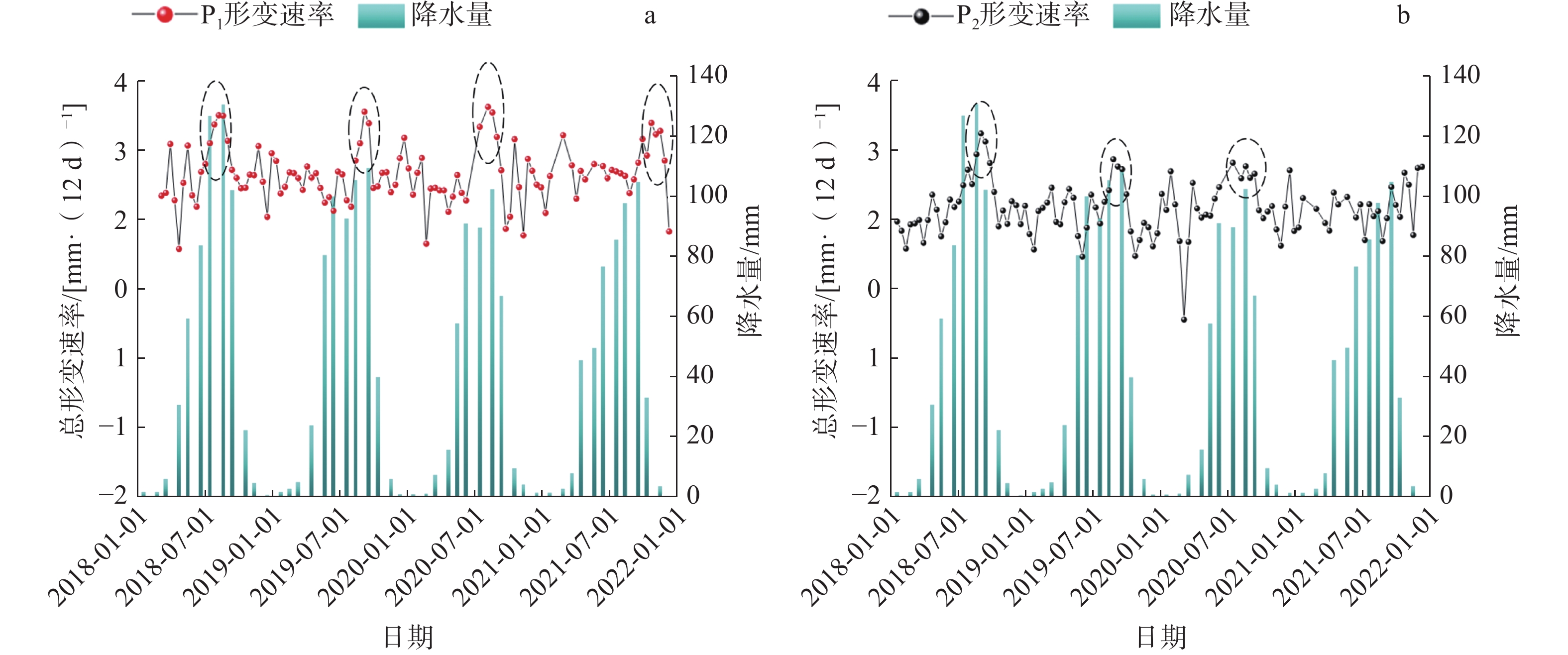
降水是诱发席芨滩古滑坡前缘局部复活的关键因素。近4年监测数据表明,1#、2#滑坡InSAR监测点P1、P2(图14)平均变形速率分别稳定在2.3 mm/(12 d)和2.0 mm/(12 d),但1#滑坡监测点P1在2018年7—9月、2019年8—9月、2020年7—9月和2021年9—10月变形速率发生突变,达到了3.5 mm/(12 d),2#滑坡监测点P2在2018年8—10月、2019年8—9月和2020年8—9月的变形速率达到了2.9~3.2 mm/(12 d),显著高于平均变形速率,结合当地降水量数据发现,上述峰值点出现的时间均是全年降水量较高的时段(7—10月),初步判断短时强降雨可能是滑坡变形速率骤增的诱因,此现象表明研究区滑坡的活动性与当地降水情况密切关联。
![]() 图 14 滑坡监测点形变速率曲线与降水量的关系Figure 14. Relationship between deformation rate curve of landslide monitoring points and precipitation
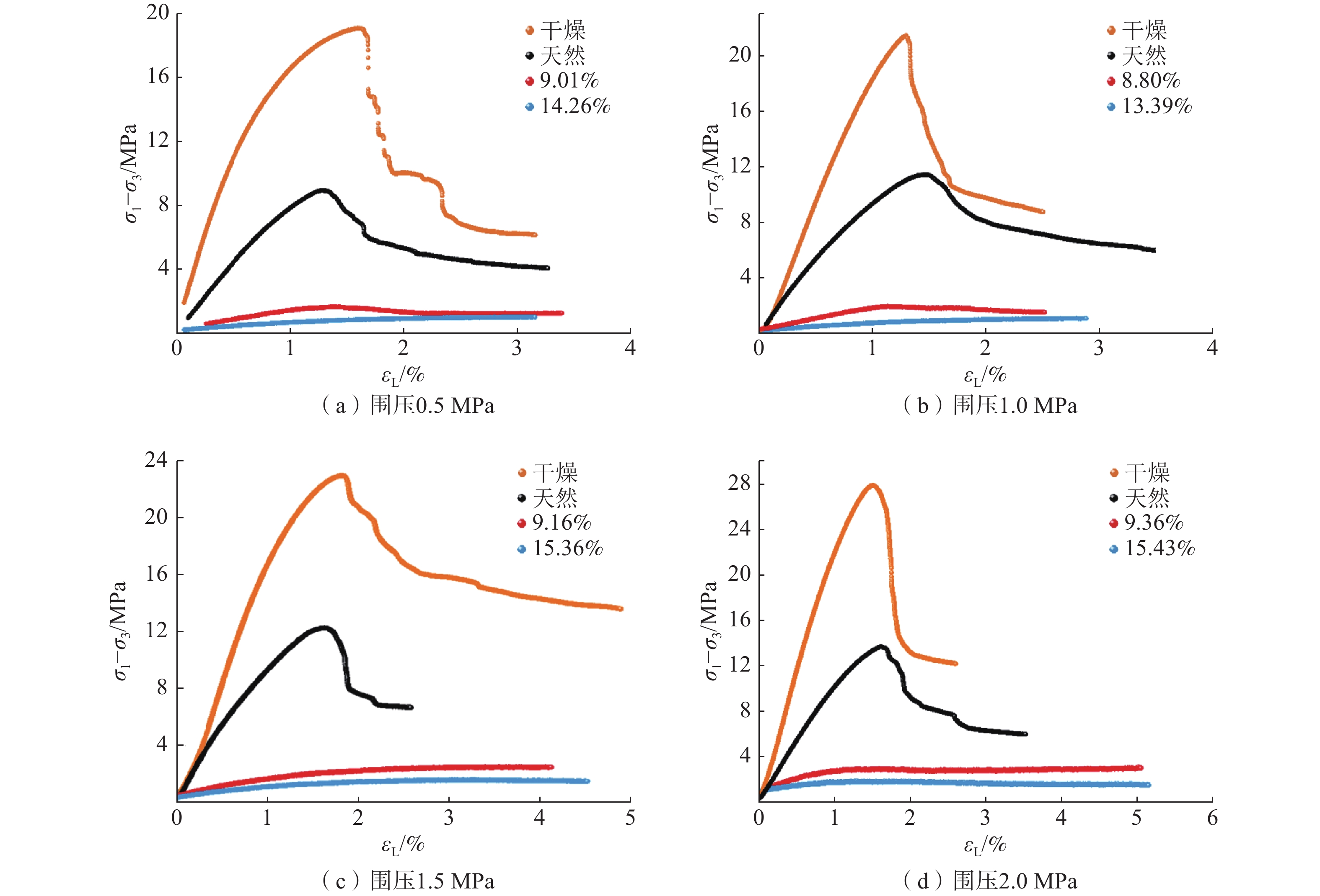
图 14 滑坡监测点形变速率曲线与降水量的关系Figure 14. Relationship between deformation rate curve of landslide monitoring points and precipitation降水影响巨型滑坡前缘局部复活主要体现在两个方面:其一,降水通过岩体结构面入渗进入坡体内部,坡体自重增加,使得降水影响范围内的浅层坡体发生滑动;其二,降雨后的水分沿结构面入渗,使得岩体软化,强度降低,促进坡体变形,进而发生滑动。针对降水致使岩体软化这一因素,本文通过设置不同含水率状态下原状泥岩的三轴剪切试验,以研究水对泥岩力学性质的影响,试样经105 °C烘干24 h后抽真空4 h,分别浸水4 h、36 h,配置成含水率为8.5%~9.5%、13.0%~15.5%的泥岩试样(泥岩试样的天然含水率为5%~6%)。
试验结果表明,含水率的变化对泥岩力学性质有非常显著的影响(图15)。当泥岩处于高含水状态时,试样在较小的荷载作用下就会产生极大的轴向应变,且随着含水率的上升,试样的弹性变形阶段在全应变过程的占比减少,试样会快速进入塑性变形阶段。此外,含水率的变化不仅影响了泥岩试样应力-应变关系的数值,还改变了泥岩的变形性质。在干燥状态和天然含水率状态下,泥岩到达峰值偏应力后进入破坏后阶段,发生应变软化现象,当泥岩处于较高含水率状态时,泥岩会产生应变硬化现象,既随着轴向应变的增加,偏应力仍会小幅度增加,此时泥岩试样会发生明显的剪涨现象。
![]() 图 15 不同含水率原状泥岩偏应力-应变曲线Figure 15. Partial stress-strain curves of undisturbed mudstone with different water contents
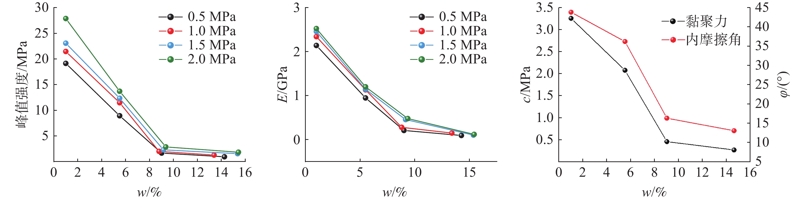
图 15 不同含水率原状泥岩偏应力-应变曲线Figure 15. Partial stress-strain curves of undisturbed mudstone with different water contents整理泥岩力学参数可以发现,泥岩试样的峰值强度、弹性模量、黏聚力和内摩擦角随含水率的增加而大幅折减(图16)。在低含水率状态下,试样具有较高的峰值强度和弹性模量,随含水率的升高,泥岩的峰值强度和弹性模量呈指数式降低,相较于干燥状态的泥岩,含水率为8%~10%的泥岩峰值强度和弹性模量软化程度达到85%以上;当泥岩的含水率大于10%时,泥岩峰值力学参数的变化幅度逐渐降低并趋于稳定。观察试样的破坏模式可以发现,干燥状态时,破坏形式呈现脆性。随着含水率的增高,试样的破坏形式变为剪破坏,饱和状态下,泥岩局部具有明显的体积膨胀现象,呈现延性破坏,说明泥岩的破坏模式随着含水率的增高逐渐由脆性向延性转换(图17)。力学试验表明了,含水状态的变化对泥岩力学性质的影响十分显著,即泥岩在低含水率状态下,少量的水分入渗便会导致岩体力学性质的明显软化。综上所述,集中降雨导致的泥岩软化是诱发次级滑坡复活的关键因素。
![]() 图 16 泥岩力学参数与含水率的关系Figure 16. The relationship between mechanical parameters and water content of mudstone
图 16 泥岩力学参数与含水率的关系Figure 16. The relationship between mechanical parameters and water content of mudstone3.3 滑坡成因机制综合分析
通过现场调查、卫星监测和室内试验总结席芨滩巨型滑坡前缘次级滑坡的复活机理为:
(1)在岩体结构方面,席岌滩古滑坡曾发生过多期滑坡活动,滑坡区力学性质较差的泥岩在高地应力作用下,内部结构面逐渐发育并切割岩体,密集发育的结构面直接降低了泥岩黏结强度,导致天然含水率泥岩峰值强度折减约40%~50%至残余强度,并间接促进地表外营力持续劣化岩体性质;
(2)在降雨与泥岩软化方面,滑坡区降雨集中,泥岩黏土矿物含量较高,具有遇水强度降低的特点,短时强降雨后,水分沿发育的结构面入渗,增加滑体质量。在浸泡过程中,泥岩含水率的增加,会导致泥岩弹性模量、峰值强度、黏聚力和内摩擦角呈指数式降低,呈现出强度折减,塑性和延性增强的软化现象;
(3)滑坡区内泥岩为力学性质较差的软岩,密集发育的结构面为地表水的入渗提供了优势渗流通道,入渗的水分会导致结构面附近的岩体泥化变形,不仅会软化深层泥岩,减小岩体间摩擦系数,还会进一步促进结构面的发育,二者的互馈作用会持续降低泥岩地层岩体的完整度和强度,影响滑坡稳定性,促进次级滑坡的变形复活(图18)。
4. 结论
(1)1#、2#滑坡是席芨滩巨型滑坡前缘发育的两处次级大型滑坡,滑坡区构造运动剧烈,地表被强烈侵蚀,岩体结构破碎疏松,主要出露地层岩性为上新统贵德组泥岩和全新统坡积物。滑坡区属高山高原气候,具有短时降雨强度大的特点。
(2)1#滑坡前后缘高差297 m,滑坡多处解体,坡体表面发生溃滑。2#滑坡前后缘相对高差319 m,平面形态为圈椅状,滑坡体分为两级平台,滑坡主滑方向约153°。滑坡后缘发育多条大型裂缝和张拉带, InSAR监测发现滑坡形变较大区域主要集中在滑坡后缘,变形区竖直向下方向最大形变速率约为91 mm/a,水平方向(方位150°)最大形变速率为116.3 mm/a,推测滑坡后缘可能处于蠕滑变形阶段。
(3)席芨滩前缘次级滑坡的复活机制与区域内岩体结构密集发育和集中降雨息息相关。密集发育的结构面直接降低泥岩的黏结强度,并间接促进地质外营力持续降低泥岩强度,对次级滑坡的复活起到控制性作用;集中降雨后的水分沿结构面入渗,导致泥岩力学性质劣化并进一步促进结构面发育,进而诱发次级滑坡复活;二者的互馈作用会持续降低泥岩地层岩体的完整度和强度,影响滑坡稳定性,促进次级滑坡的变形复活。
-
![]()
图 2 席芨滩滑坡概况图
注:a为席芨滩滑坡位置图;b为席芨滩滑坡分期图;c为席芨滩滑坡剖面图[30];d为次级滑坡航拍图;e、f、g为席芨滩滑坡分期发育特征。
Figure 2. Overview of the location of Xijitan landslide
![]()
图 11 泥岩峰值强度、残余强度与围压的关系
Figure 11. The relationship between peak strength, residual strength, and confining pressure of mudstone
![]()
图 12 优势入渗促进结构面发育机制图
Figure 12. Mechanism diagram of dominant infiltration-promoted structural plane development
![]()
图 14 滑坡监测点形变速率曲线与降水量的关系
Figure 14. Relationship between deformation rate curve of landslide monitoring points and precipitation
![]()
图 15 不同含水率原状泥岩偏应力-应变曲线
Figure 15. Partial stress-strain curves of undisturbed mudstone with different water contents
![]()
图 16 泥岩力学参数与含水率的关系
Figure 16. The relationship between mechanical parameters and water content of mudstone
表 1 泥岩峰值强度和残余强度拟合参数
Table 1 Fitting parameters for peak strength and residual strength of mudstone
a b R2 峰值强度 3.028 ± 0.479 7.835 ± 0.656 0.9523 残余强度 3.663 ± 0.209 1.517 ± 0.287 0.9935  下载: 导出CSV
-
[1] 殷跃平, 高少华. 高位远程地质灾害研究: 回顾与展望[J]. 中国地质灾害与防治学报,2024,35(1):1 − 18. [YIN Yueping, GAO Shaohua. Research on high-altitude and long-runout rockslides: review and prospects[J]. The Chinese Journal of Geological Hazard and Control,2024,35(1):1 − 18. (in Chinese with English abstract)] YIN Yueping, GAO Shaohua. Research on high-altitude and long-runout rockslides: review and prospects[J]. The Chinese Journal of Geological Hazard and Control, 2024, 35(1): 1 − 18. (in Chinese with English abstract)
[2] 兰恒星,彭建兵,祝艳波,等. 黄河流域地质地表过程与重大灾害效应研究与展望[J]. 中国科学:地球科学,2022,52(2):199 − 221. [LAN Hengxing,PENG Jianbing,ZHU Yanbo,et al. Research and prospect of geological surface processes and major disaster effects in the Yellow River Basin[J]. Science Chinese:Earth Science,2022,52(2):199 − 221. (in Chinese with English abstract)] LAN Hengxing, PENG Jianbing, ZHU Yanbo, et al. Research and prospect of geological surface processes and major disaster effects in the Yellow River Basin[J]. Science Chinese: Earth Science, 2022, 52(2): 199 − 221. (in Chinese with English abstract)
[3] YIN Z,QIN X,YIN Y,et al. Landslide developmental characteristics and response to climate change since the last glacial in the upper reaches of the Yellow River,NE Tibetan Plateau[J]. Acta Geologica Sinica‐English Edition,2014,88(2):635 − 646. DOI: 10.1111/1755-6724.12219
[4] 胡贵寿. 青海省特大型滑坡发育分布规律[D]. 北京:中国地质大学,2013. [HU Guishou. Development and distribution patterns of large-scale landslides in Qinghai Province [D]. Beijing:China University of Geosciences,2013 (in Chinese with English abstract)] HU Guishou. Development and distribution patterns of large-scale landslides in Qinghai Province [D]. Beijing: China University of Geosciences, 2013 (in Chinese with English abstract)
[5] 崔之久,伍永秋,刘耕年,等. 关于“昆仑-黄河运动”[J]. 中国科学(D辑),1998,28(1):53 − 59. [CUI Zhijiu,WU Yongqiu,LIU Gengnian,et al. On the Kunlun Yellow River Movement[J]. Science In Chinese (Series D),1998,28(1):53 − 59. (in Chinese with English abstract)] CUI Zhijiu, WU Yongqiu, LIU Gengnian, et al. On the Kunlun Yellow River Movement[J]. Science In Chinese (Series D), 1998, 28(1): 53 − 59. (in Chinese with English abstract)
[6] 张春山. 黄河上游地区地质灾害形成条件与风险评价研究[D]. 北京:中国地质科学院,2003. [ZHANG Chunshan. Study on the formation conditions and risk assessment about geological hazards in the upper reaches of the Yellow River [D]. Beijing: Chinese Academy of Geological Sciences,2003. (in Chinese with English abstract)] ZHANG Chunshan. Study on the formation conditions and risk assessment about geological hazards in the upper reaches of the Yellow River [D]. Beijing: Chinese Academy of Geological Sciences, 2003. (in Chinese with English abstract)
[7] 贾润幸,方维萱,张建国,等. 山西清徐——太谷地区地裂缝形成机理[J]. 地质通报,2022,41(7):1282 − 1290. [JIA Runxing,FANG Weixuan,ZHANG Jianguo,et al. The formation mechanism of ground fissures in the Qingxu Taigu area of Shanxi Province[J]. Geolgical Bulletin of China,2022,41(7):1282 − 1290. (in Chinese with English abstract)] JIA Runxing, FANG Weixuan, ZHANG Jianguo, et al. The formation mechanism of ground fissures in the Qingxu Taigu area of Shanxi Province[J]. Geolgical Bulletin of China, 2022, 41(7): 1282 − 1290. (in Chinese with English abstract)
[8] 范宣梅,方成勇,戴岚欣,等. 地震诱发滑坡空间分布概率近实时预测研究——以2022年6月1日四川芦山地震为例[J]. 工程地质学报,2022,30(3):729 − 739. [FAN Xuanmei,FANG Chengyong,DAI Lanxin,et al. Near real time prediction of spatial distribution probability of earthquake-induced landslides: Take the Lushan Earthquake on June 1,2022 as an example[J]. Journal of Engineering Geology,2022,30(3):729 − 739. (in Chinese with English abstract)] FAN Xuanmei, FANG Chengyong, DAI Lanxin, et al. Near real time prediction of spatial distribution probability of earthquake-induced landslides: Take the Lushan Earthquake on June 1, 2022 as an example[J]. Journal of Engineering Geology, 2022, 30(3): 729 − 739. (in Chinese with English abstract)
[9] 殷跃平,王文沛,张楠,等. 强震区高位滑坡远程灾害特征研究——以四川茂县新磨滑坡为例[J]. 中国地质,2017,44(5):827 − 841. [YIN Yueping,WANG Wenpei,ZHANG Nan,et al. Long runout geological disaster initiated by the ridge-top rockslide in a strong earthquake area:A case study of the Xinmo landslide in Maoxian County,Sichuan Province[J] Geology in China,2017,44(5):827 − 841. (in Chinese with English abstract)] YIN Yueping, WANG Wenpei, ZHANG Nan, et al. Long runout geological disaster initiated by the ridge-top rockslide in a strong earthquake area: A case study of the Xinmo landslide in Maoxian County, Sichuan Province[J] Geology in China, 2017, 44(5): 827 − 841. (in Chinese with English abstract)
[10] 杨琴,范宣梅,许强,等. 北川唐家湾滑坡变形历史与形成机制研究[J]. 水文地质工程地质,2018,45(2):136 − 141. [YANG Qin,FAN Xuanmei,XU Qiang,et al. A study of the deformation history and mechanism of the Tangjiawan landslide[J]. Hydrogeology & Engineering Geology,2017,44(5):827 − 841. (in Chinese with English abstract)] YANG Qin, FAN Xuanmei, XU Qiang, et al. A study of the deformation history and mechanism of the Tangjiawan landslide[J]. Hydrogeology & Engineering Geology, 2017, 44(5): 827 − 841. (in Chinese with English abstract)
[11] CHEN G,JIN JC,MENG X,et al. Influence of tectonic effects on the formation and characteristics of landslide dams on the NE Tibetan Plateau:A case study in the Bailong River Basin,China[J]. Landslides,2024:1 − 19.
[12] YU H,LI A,et al. "Present-day crustal deformation and strain transfer in northeastern Tibetan Plateau[J]. Earth and Planetary Science Letters,487(2018):179 − 189.
[13] 周保,马涛,魏正发,等. 黄河上游曲哇加萨滑坡“9•20”动力学过程模拟与分析[J]. 中国地质灾害与防治学报,2022,33(2):9 − 15. [ZHOU Bao,MA Tao,WEI Zhengfai,et al. Dynamic simulation and analysis of “9•20” sliding process of Quwajiasa landslide in the upper reaches of Yellow River[J]. The Chinese Journal of Geological Hazard and Control,2022,33(2):9 − 15. (in Chinese with English abstract)] ZHOU Bao, MA Tao, WEI Zhengfai, et al. Dynamic simulation and analysis of “9•20” sliding process of Quwajiasa landslide in the upper reaches of Yellow River[J]. The Chinese Journal of Geological Hazard and Control, 2022, 33(2): 9 − 15. (in Chinese with English abstract)
[14] 魏刚,殷志强,马吉福,等. 黄河上游阿什贡滑坡群发育期次及演化过程分析[J]. 水文地质工程地质,2016,43(6):133 − 140. [WEI Gang,YIN Zhiqiang,MA Jifu,et al. An analysis of forming stages and evolution process of the Ashigong landslide cluster in the upper reaches of the Yellow River[J]. Hydrogeology & Engineering Geology,2016,43(6):133 − 140. (in Chinese with English abstract)] WEI Gang, YIN Zhiqiang, MA Jifu, et al. An analysis of forming stages and evolution process of the Ashigong landslide cluster in the upper reaches of the Yellow River[J]. Hydrogeology & Engineering Geology, 2016, 43(6): 133 − 140. (in Chinese with English abstract)
[15] 李小林,郭小花,李万花. 黄河上游龙羊峡—刘家峡河段巨型滑坡形成机理分析[J]. 工程地质学报,2011,19(4):516 − 529. [LI Xiaolin,GUO Xiaohua,LI Wanhua. Mechanism of giant landslides from Longyangxia Vally to Liujiaxia Vally along upper Yellow River[J]. Journal of Engineering Geology,2011,19(4):516 − 529. (in Chinese with English abstract)] DOI: 10.3969/j.issn.1004-9665.2011.04.013 LI Xiaolin, GUO Xiaohua, LI Wanhua. Mechanism of giant landslides from Longyangxia Vally to Liujiaxia Vally along upper Yellow River[J]. Journal of Engineering Geology, 2011, 19(4): 516 − 529. (in Chinese with English abstract) DOI: 10.3969/j.issn.1004-9665.2011.04.013
[16] 张永双,杜国梁,姚鑫,等. 塔吉克斯坦MS7.2级地震滑坡危险性快速评估及其对中国西部边疆山区巨灾风险防控的启示[J]. 地质学报,2023,97(5):1371 − 1382. [ZHANG Yongshuang,DU Guoliang,YAO Xin,et al. Rapid assessment of landslide risk during the MS7.2 earthquake in Tajikistan inspiration on disaster risk prevention and control in the mountainous regions of western China's border regions[J]. Acta Geologica Sinica,2023,97(5):1371 − 1382. (in Chinese with English abstract)] DOI: 10.3969/j.issn.0001-5717.2023.05.001 ZHANG Yongshuang, DU Guoliang, YAO Xin, et al. Rapid assessment of landslide risk during the MS7.2 earthquake in Tajikistan inspiration on disaster risk prevention and control in the mountainous regions of western China's border regions[J]. Acta Geologica Sinica, 2023, 97(5): 1371 − 1382. (in Chinese with English abstract) DOI: 10.3969/j.issn.0001-5717.2023.05.001
[17] 邓威,肖世国. 含裂隙近水平红层软岩边坡渗透稳定性模型试验[J]. 水文地质工程地质,2024,51(1):57 − 68. [DENG Wei,XIAO Shiguo. Model test on stability of soft rock slopes composed of nearly horizontal redbeds with cracks[J]. Hydrogeology & Engineering Geology,2024,51(1):57 − 68. (in Chinese with English abstract)] DENG Wei, XIAO Shiguo. Model test on stability of soft rock slopes composed of nearly horizontal redbeds with cracks[J]. Hydrogeology & Engineering Geology, 2024, 51(1): 57 − 68. (in Chinese with English abstract)
[18] 刘建强,许强,郑光,等. 贵州省鸡场滑坡地下水化学特征反映的水-岩(土)作用[J]. 水文地质工程地质,2023,50(2):132 − 140. [LIU Jianqiang,XU Qiang,ZHENG Guang,et al. Water-rock /soil interaction reflected by the chemical characteristics of groundwater of Jichang landslide in Guizhou Province[J]. Hydrogeology & Engineering Geology,2023,50(2):132 − 140. (in Chinese with English abstract)] LIU Jianqiang, XU Qiang, ZHENG Guang, et al. Water-rock /soil interaction reflected by the chemical characteristics of groundwater of Jichang landslide in Guizhou Province[J]. Hydrogeology & Engineering Geology, 2023, 50(2): 132 − 140. (in Chinese with English abstract)
[19] KONG Lingwei,ZENG Zhixiong,BAI Wei,et al. Engineering geological properties of weathered swelling mudstones and their effects on the landslides occurrence in the Yanji section of the Jilin-Hunchun high-speed railway[J]. Bulletin of Engineering Geology and the Environment,2018,77(4):1491 − 1503. DOI: 10.1007/s10064-017-1096-2
[20] ZHOU Zhe,CHEN Shanxiong,WANG Yinhui,et al. Crack evolution characteristics and cracking mechanism of red beds in central Sichuan during seepage and swelling[J]. Geofluids,2021,Article ID 9981046:1 − 19.
[21] WANG H J,SUN P,ZHANG S,et al. Rainfall-induced landslide in loess area,Northwest China:A case study of the Changhe landslide on September 14,2019,in Gansu Province[J]. Landslides,2020,17(9):2145 − 2160 DOI: 10.1007/s10346-020-01460-0
[22] LIU Y J,CHIU Y Y,TSAI F T C,et al. Analysis of landslide occurrence time via rainfall intensity and soil water index ternary diagram[J]. Landslides,2022,19(12):2823 − 2837. DOI: 10.1007/s10346-022-01944-1
[23] 魏刚,殷志强,罗银飞,等. 黄河上游康杨滑坡堆积体特征及形成机理分析[J]. 中国地质灾害与防治学报,2022,33(2):1 − 8. [WEI Gang,YIN Zhiqiang,LUO Yinfei,et al. Analysis on the accumulation deposits characteristics and formation mechanism of Kangyang landslide in the upper reaches of Yellow River[J]. The Chinese Journal of Geological Hazard and Control,2022,33(2):1 − 8. (in Chinese with English abstract)] WEI Gang, YIN Zhiqiang, LUO Yinfei, et al. Analysis on the accumulation deposits characteristics and formation mechanism of Kangyang landslide in the upper reaches of Yellow River[J]. The Chinese Journal of Geological Hazard and Control, 2022, 33(2): 1 − 8. (in Chinese with English abstract)
[24] CHEN L,YANG H,SONG K,et al. Failure mechanisms and characteristics of the Zhongbao landslide at Liujing Village,Wulong,China[J]. Landslides,2021,18(4):1445 − 1457. DOI: 10.1007/s10346-020-01594-1
[25] 万飞鹏,杨为民,邱占林,等. 甘肃岷县纳古呢沟滑坡-泥石流灾害链成灾机制及其演化[J]. 中国地质,2023,50(3):911 − 925. [WAN Feipeng,YANG Weimin,QIU Zhanlin,et al. Disaster mechanism and evolution of Nagune Gully landslide-debris flow disaster chain in Minxian County,Gansu Province[J]. Geology in China,2023,50(3):911 − 925. (in Chinese with English abstract)] WAN Feipeng, YANG Weimin, QIU Zhanlin, et al. Disaster mechanism and evolution of Nagune Gully landslide-debris flow disaster chain in Minxian County, Gansu Province[J]. Geology in China, 2023, 50(3): 911 − 925. (in Chinese with English abstract)
[26] GRABER A,SANTI P,MEZA Arestegui P. Constraining the critical groundwater conditions for initiation of large,irrigation-induced landslides,Siguas River Valley,Peru[J]. Landslides,2021,18(12):3753 − 3767. DOI: 10.1007/s10346-021-01767-6
[27] 史立群,魏刚,殷志强,等. 青海尖扎盆地寺门村滑坡发育特征及成因分析[J]. 中国地质灾害与防治学报,2020,31(5):15 − 21. [SHI Liqun,WEI Gang,YIN Zhiqiang,et al. Characteristics and formation of Simencun landslides in Jianzha Basin of Qinghai Province[J]. The Chinese Journal of Geological Hazard and Control,2020,31(5):15 − 21. (in Chinese with English abstract)] SHI Liqun, WEI Gang, YIN Zhiqiang, et al. Characteristics and formation of Simencun landslides in Jianzha Basin of Qinghai Province[J]. The Chinese Journal of Geological Hazard and Control, 2020, 31(5): 15 − 21. (in Chinese with English abstract)
[28] 冉林,马鹏辉,彭建兵,等. 甘肃黑方台“10•5”黄土滑坡启动及运动特征分析[J]. 中国地质灾害与防治学报,2022,33(6):1 − 9. [RAN Lin,MA Penghui,PENG Jianbing,et al. The initiation and motion characteristics of the “10•5” loess landslide in the Heifangtai platform,Gansu Province[J]. The Chinese Journal of Geological Hazard and Control,2022,33(6):1 − 9. (in Chinese with English abstract)] RAN Lin, MA Penghui, PENG Jianbing, et al. The initiation and motion characteristics of the “10•5” loess landslide in the Heifangtai platform, Gansu Province[J]. The Chinese Journal of Geological Hazard and Control, 2022, 33(6): 1 − 9. (in Chinese with English abstract)
[29] 潘保田. 贵德盆地地貌演化与黄河上游发育研究[J]. 干旱区地理,1994(3):43 − 50. [PAN Baotian. Study on the landform evolution of the Guide Basin and the development of the upper Yellow River[J]. Arid Area Geography,1994(3):43 − 50. (in Chinese with English abstract)] DOI: 10.13826/j.cnki.cn65-1103/x.1994.03.006. PAN Baotian. Study on the landform evolution of the Guide Basin and the development of the upper Yellow River[J]. Arid Area Geography, 1994(3): 43 − 50. (in Chinese with English abstract) DOI: 10.13826/j.cnki.cn65-1103/x.1994.03.006.
[30] 赵无忌,殷志强,马吉福,等. 黄河上游贵德盆地席芨滩巨型滑坡发育特征及地貌演化[J]. 地质论评,2016,62(3):709 − 721. [ZHAO Wuji,YIN Zhiqiang,MA Jifu,et al. Development characteristics and geomorphological evolution of the Xijitan giant landslide in the Guide Basin of the Upper Yellow River[J]. Geological Review,2016,62(3):709 − 721. (in Chinese with English abstract)] DOI: 10.16509/j.georeview.2016.03.013. ZHAO Wuji, YIN Zhiqiang, MA Jifu, et al. Development characteristics and geomorphological evolution of the Xijitan giant landslide in the Guide Basin of the Upper Yellow River[J]. Geological Review, 2016, 62(3): 709 − 721. (in Chinese with English abstract) DOI: 10.16509/j.georeview.2016.03.013.
[31] 赵无忌. 黄河上游贵德盆地滑坡泥石流扇发育特征及地貌演化过程[D]. 北京:中国地质大学(北京),2015. [ZHAO Wuji. The formation characteristics and geomorphical evolution of the landslides and debris flow fans in Guide Basin,the upper Yellow River [D]. Beijing: China University of Geosciences (Beijing),2015. (in Chinese with English abstract)] ZHAO Wuji. The formation characteristics and geomorphical evolution of the landslides and debris flow fans in Guide Basin, the upper Yellow River [D]. Beijing: China University of Geosciences (Beijing), 2015. (in Chinese with English abstract)
[32] CRADDOCK W H, KIRBY E, HARKINS N W, et al. Rapid fluvial incision along the Yellow River during headward basin integration[J]. Nature Geoscience,2010(3):209 − 213.
[33] ZHANG H, ZHANG P, CHAMPAGNAC J D, et al. Pleistocene drainage reorganization driven by the isostatic response to deep incision into the northeastern Tibetan Plateau[J]. Geology, 2014, 42(4): 303-306.
[34] 周保. 黄河上游(拉干峡—寺沟峡段)特大型滑坡发育特征与群发机理研究[D]. 西安: 长安大学, 2010. [ZHOU Bao. Study on the development characteristics and mass mechanism of super-large landslide in the upper reaches of the Yellow River (Laganxia-Sigouxia section)[D]. Xi’an: Chang’an University, 2010. (in Chinese with English abstract)] ZHOU Bao. Study on the development characteristics and mass mechanism of super-large landslide in the upper reaches of the Yellow River (Laganxia-Sigouxia section)[D]. Xi’an: Chang’an University, 2010. (in Chinese with English abstract)
[35] National Earth System Science Data Center,National Science & Technology Infrastructure of China (http://www.geodata.cn).
[36] 刘佑荣,唐辉明. 岩体力学[M]. 北京:化学工业出版社,2009. [LIU Yourong,TANG Huiming. Rock mass mechanics[M]. Beijing:Chemical Industry Press,2009. (in Chinese)] LIU Yourong, TANG Huiming. Rock mass mechanics[M]. Beijing: Chemical Industry Press, 2009. (in Chinese)
-
期刊类型引用(2)
1. 姜超,孙宇超,龚梦洋,李忠鹏. 软弱结构面的赋存条件对露天矿顺层岩质边坡劣化的数值模拟研究. 中国金属通报. 2021(08): 172-175 .  百度学术
百度学术
2. 杜世回,张晓宇,章广成,常帅鹏,高旭,孟祥连,苗晓岐,黄勇. 西藏易贡藏布高陡岸坡卸荷带发育特征及其工程意义. 地质通报. 2021(12): 2043-2051 . 百度学术
其他类型引用(0)


计量
- 文章访问数: 515
- HTML全文浏览量: 89
- PDF下载量: 164
- 被引次数: 2
 邮件订阅
邮件订阅 RSS
RSS