

Application of SBAS-InSAR technology to analyze the evolution characteristics and cause of ground subsidence in Sanhe City, Hebei Province
-
摘要:
2003—2016年,三河市地面沉降速率逐步加大,其中燕郊地区地面沉降最严重,已和北京通州沉降区连成一片,2016年之后三河市地面沉降灾害的发展变化趋势尚不明确。随着京津冀一体化发展、北京城市副中心建设等国家政策的出台,查明三河市地面沉降灾害的发展演化特征并分析成因对保障三河市的城市安全和可持续发展至关重要。文章采用SBAS-InSAR技术解译三河市2018—2020年地面沉降发展演化特征,同时分析了导致三河市地面沉降的几个诱发因素,总结沉降原因。通过本次研究,掌握了三河市地面沉降灾害的空间分布及演化特征:三河市地面沉降在空间上呈现西部严重,东部较缓,发育重点沉降区的总体特征;主要发育有2个重点沉降区,分别为含3个沉降漏斗的燕郊镇沉降区和含1个沉降漏斗的段甲岭镇沉降区,其中燕郊镇沉降区为三河市地面沉降最为严重的区域;2018—2020年,三河市地面沉降灾害总体呈现减缓趋势。同时通过对比分析,三河市地下水的严重超采、土层性质、城镇化发展及人口激增是三河市地面沉降灾害发生及发展的主要因素。研究成果将为该区域地面沉降灾害的防治提供参考。
Abstract:According to studies by relevant scholars, the ground subsidence rate in Sanhe City, Hebei, increased gradually from 2003 to 2016, with the most severe subsidence observed in the Yanjiao area , which has become contiguous with the subsidence area in Tongzhou, Beijing. However, the development trend of ground subsidence disasters in Sanhe City after 2016 remains unclear. With the implementation of national policies such as the integration of Beijing-Tianjin-Hebei region and the construction of Beijing’s sub-center, it is crucial to identify the development and evolution characteristics of land subsidence disasters in Sanhe City and analyze their causes to ensure the urban safety and sustainable development of Sanhe City. In this context, the authors used SBAS-InSAR technology to interpret the evolution characteristics of ground subsidence in Sanhe City from 2018 to 2020, and analyzed several inducing factors that led to land subsidence in Sanhe City, summarizing the main causes. Through this study, the spatial distribution and evolutionary characteristics of land subsidence disasters in Sanhe City were grasped: the western part of the city exhibits severe subsidence, while the eastern part is less affected, with a focus on the overall characteristics of key subsidence areas. Two main subsidence areas were identified, namely, the Yanjiao Town subsidence area with three subsidence funnels and the DuanJialing town subsidence area with one subsidence funnel, with the former being the most severely affected. From 2018 to 2020, the overall trend of ground subsidence disasters in Sanhe City showed a slowdown. Through comparative analysis, it was determined that severe overexploitation of groundwater, soil properties, urbanization development, and population growth are the main factors contributing to the occurrence and development of ground subsidence disasters in Sanhe City. The research results of this paper will provide reference for the prevention and control of ground subsidence disasters in the region.
-
0. 引言
地面沉降是指由于自然因素或人类工程活动引发的松散层固结压缩并导致一定区域内地面高程降低的地质现象。中国地面沉降灾害始于20世纪20年代,华北平原是中国地面沉降最严重的地区之一。其中京津冀地区城市发展建设的不断加快、人类工程和经济活动的不断加剧,加重了对地质资源的索取和干扰,导致地面沉降等一系列地质灾害的产生和快速发展,三河市位于该沉降区域之中。
传统地面沉降监测方法包括:水准测量、GPS测量等方法,缺点是监测周期长、人力物力消耗大、实时性弱[1]。合成孔径雷达干涉测量(interferometry syntheic aperture radar, InSAR)是近些年兴起的地面沉降监测新方法,优点是:精度高、范围广、全天候观测等[2]。20世纪60年代,NASA首次采用InSAR技术对火星和月球表面进行观测。Gabriel等[3]在1989年提出了D-InSAR技术,并说明该技术可用于许多地球物理现象的精确测量,包括断层带、地震位移和火山膨胀。Ferretti等[4]在2001年提出PS-InSAR技术,并使用该技术对美国Pomona市区及周边进行了地面沉降观测,实验结果表明6年间最大沉降量是−20 cm,最大的隆起量为6 cm。最早Berardino等[5]在2002年提出了SBAS-InSAR技术,并使用了1992—2002年欧洲遥感数据、Campi Flegrei火山口和Naples市数据,证明了SBAS-SAR技术有动态变化监测的能力。
罗三明等[6]采用PS-InSAR方法获取了北京及周边地区2006—2010年的地面沉降时间序列演化特征。其中燕郊地区沉降速率为19.66 mm/a,三河城区地面沉降速率为10 mm/a,且沉降速率呈持续增长的趋势。郭海朋等[7]采用GRACE卫星数据反演技术获取并分析了华北平原地面沉降发展历史和现状,其中三河地区在2003—2010年的地面沉降速率10~24 mm/a。周旭等[8]采用InSAR TS+AEM监测技术,获取了2007年4月—2010年9月三河市的形变监测结果,其中三河市燕郊沉降速率为19 mm/a,东部城区年沉降速率接近5 mm/a。李海君等[9]采用改进PS-InSAR技术获取研究区2007—2010年三河市地面沉降时间序列演化特征,三河市燕郊地区年均沉降速率最大达25.58 mm/a,宋庄−燕郊沉降区与通州沉降漏斗已连为一片。李广宇等[10]采用TS-DInSAR技术,成功获取了三河市2015—2016年的地面沉降速率,其中燕郊镇的沉降速率为104 mm/a,累积沉降量达到121 mm;三河市城区地面沉降速率为60~80 mm/a。通过众多学者对三河市地区地面沉降演化特征的研究成果可知,在2003—2016年期间,三河市地面沉降速率逐步加大,其中燕郊地区地面沉降最为严重。随着三河市的发展建设,2016年之后三河市地面沉降灾害的发展变化趋势尚不明确,在此背景下,笔者采用SBAS-InSAR技术解译三河市2016—2021年地面沉降发展演化特征,并对成因机理进行探讨,为该区域地面沉降灾害的防治提供重要的技术参考。
1. 研究区域与数据源
1.1 研究区域概况
三河市位于河北省廊坊市北部,西邻北京,东接天津,地处燕山山前平原地区,地势北高南低,自北向南倾斜,按地形地貌特点,可分为低山丘陵、流水地貌和平原洼地地貌。其中平原面积最大,主要由潮白河、蓟运河冲洪积扇构成,平均高程5.9~31.9 m,地面自然纵坡1/1500左右,低山丘陵主要分布在东北部的蒋福山地区。洼地主要分布在本市东南部的引泃入潮与鲍邱河、潮白河两岸,地势低平、多积水洼地,(图1)。燕郊开发区辖燕郊镇和高楼镇,西距天安门30 km,距首都机场25 km,南距天津港120 km,是全国离北京市中心最近的开发区。近年来,京津冀一体化进程的不断推进,燕郊的交通道路网、城市功能配套、房地产业得到了迅猛发展,已经建设成为初具规模的新兴城市。
1.2 数据源
本文采用了自2018-01-03至2021-08-03共100期欧空局的Sentinel-1A高分辨率雷达影像数据,分辨率为5 m×20 m,升轨数据,VV极化,IW成像模式。DEM数据采用NASA提供的90 m分辨率的STRM数字高程模型[11]。精密轨道数据采用欧空局的POD precise Orbit Ephemerides,其定位精度优于5 cm[12]。
为同期验证InSAR数据精度,在三河市平原区布设4条二等水准路线,59个二等水准监测点进行水准测量,水准点间距500~2 000 m不等,路线长度约88.3 km,水准路线分布如图1所示。第一次水准测量时间为2020-07-15至2020-08-10,第二次水准测量时间为2021-07-22至2021-08-15。水准测量使用采用Trimble DINI03系列电子水准仪及配套的条码尺进行观测,测量精度为每千米水准测量偶然中误差为±0.61mm,限差为±1.0mm;每千米水准测量全中误差为±0.32 mm,限差为±2.0 mm[13]。选取2020年8月—2021年8月一年完整的水准测量成果与InSAR数据进行对比。
2. SBAS-InSAR数据处理
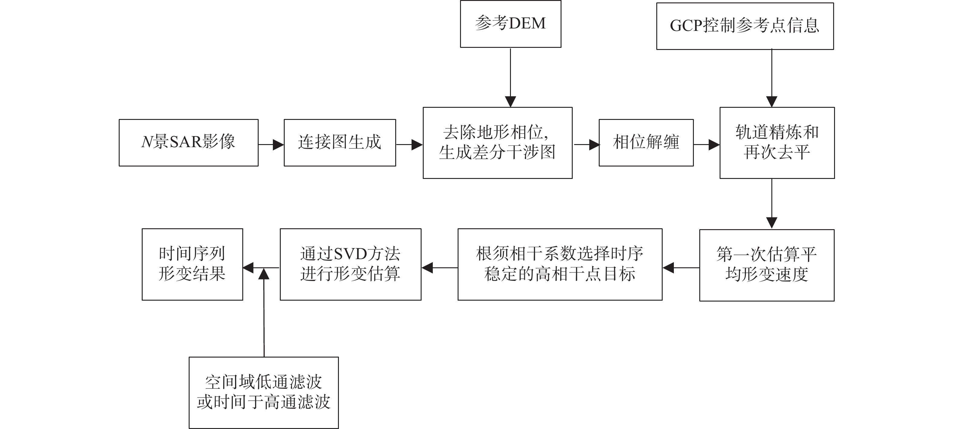
SBAS通过简单和高效地组合成所有可用的小基线干涉图对,再基于形变速率最小范围数准则,通过SVD方法获取相干目标的形变速率及其时间序列[14]。其包括2个优点:(1)通过使用所有获取的包含在差分小基线集里的数据增加时间采样率;(2)提供了高空间密度的形变测量。本文使用SARscape软件,利用N景SAR影像生成连接图[15]。将差分干涉对进行差分处理并结合参考DEM数据生成差分干涉图。相位解缠是需要从不存在较大形变的稳定区域选择相干性高的控制点作为形变信息对比参考点,进而利用线型模型对初始位移进行估计,去除残余地形。对差分干涉图进行二次解缠处理,得到第一次反演结果[16]。然后,利用第一次反演成果结合控制点点去除恒定相位和斜坡相位,最终得到时间序列上的位移变化。将所收集到的数据根据2018、2019、2020年分成3组,来获得3年的地面沉降变化量。用2020-08-08至2021-08-03共31期影像处理成果对比同期的水准测量来验证InSAR影像的精度,技术路线如图2所示。
InSAR的最终结果为LOS方向沉降量,为了与水准成果对比需转换成垂直方向形变量。将两种时间序列处理的视线向(LOS)形变结果分解到垂直地表的方向上。地表沉降量可表示为:
(1) 式中:S——地表沉降量/mm;
d——地表沿雷达视线方向的形变量/mm;
θ——雷达视线的入射角(雷达视线方向和垂直地 表直线的夹角)/(°)。
3. 结果与分析
3.1 精度评价
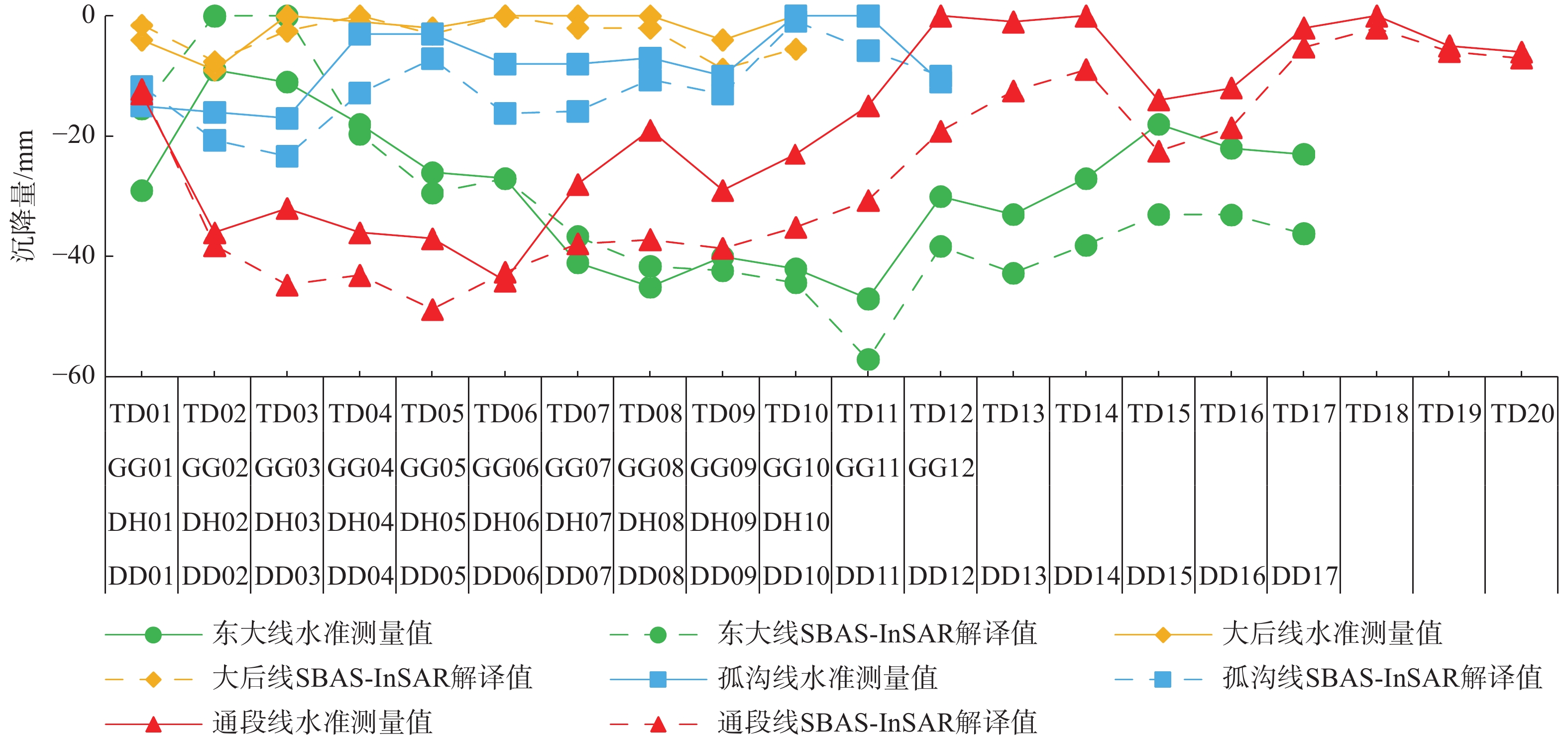
三河市内共计布设有水准测量线4条,分别为东大线(东南各庄村−大石各庄村)、大后线(大石庄村−后葛庄村)、孤沟线(孤山营村−沟北庄村)、通段线(通州−段甲岭)。东大线包括二等水准点17个,编号DD01—DD17;大后线包括二等水准点10个,编号DH01—DH10;孤沟线包括二等水准点12个,编号GG01—GG12;通段线包括二等水准点20个,编号TD01—TD20[17]。
由于水准点位置与SDFP点位置并非一一对应,故以水准点为圆心,做半径为100 m的圆,在附近查找相干点与对应的水准点进行比较[18]。InSAR成果和水准成果对比见图3,两者平均差值为6.8 mm/a,最小差值为0 mm,均方根误差为8.02 mm,精度达到毫米级别。整体上看,同一水准路线上的InSAR解译成果与水准测量成果的变化趋势基本一致,特别是对沉降严重区的监测精度较高。InSAR方法监测形变精度达到毫米级,表明InSAR对区域地面沉降解译结果较为可靠。
![]() 图 3 水准测量值与SBAS-InSAR解译值对比图Figure 3. Comparison between leveling measurement values and SBAS-InSAR interpreted values
图 3 水准测量值与SBAS-InSAR解译值对比图Figure 3. Comparison between leveling measurement values and SBAS-InSAR interpreted values3.2 2018—2020年三河市地面沉降演化特征
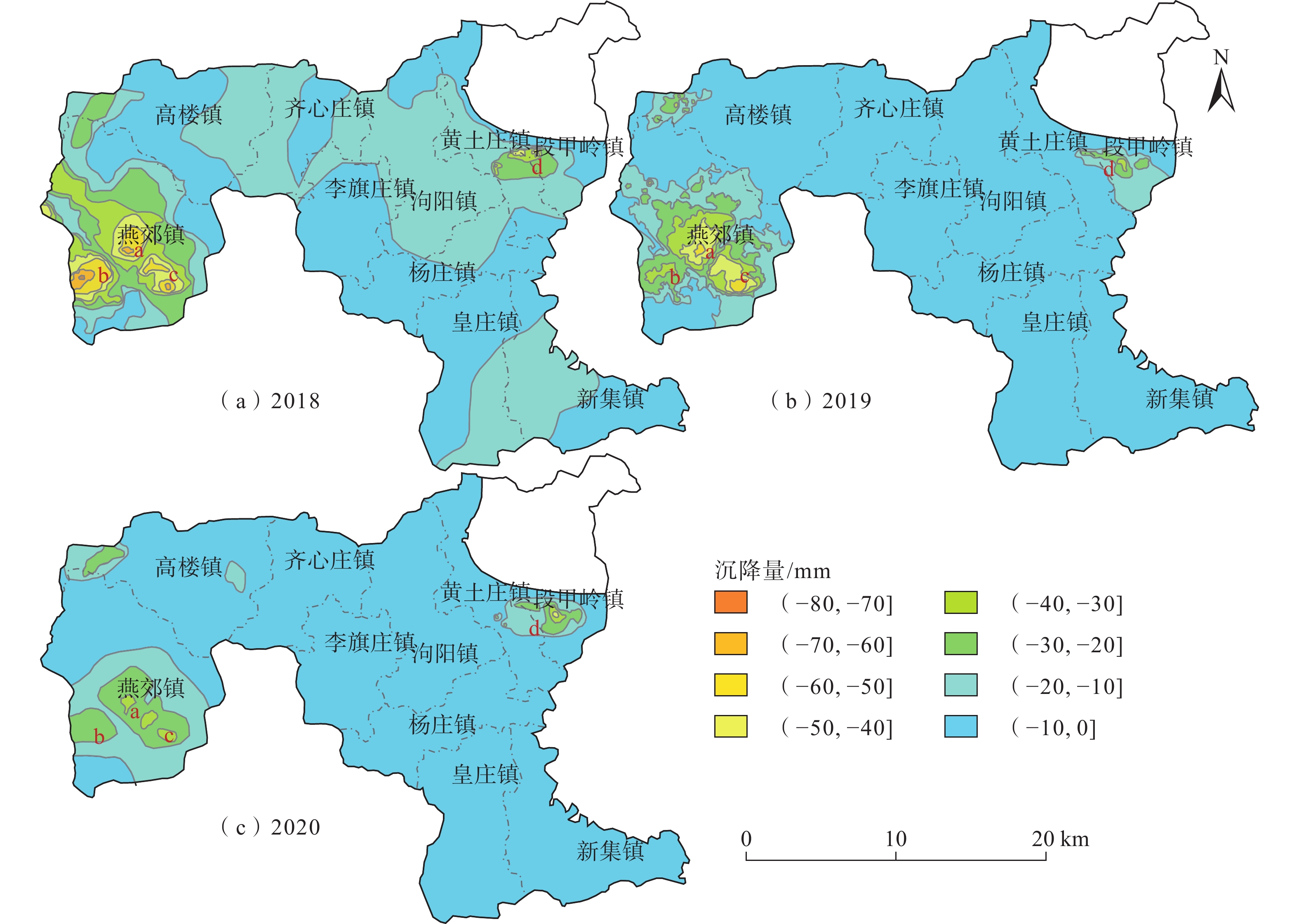
通过SBAS-InSAR手段获得2018—2020年三河市地面沉降时序形变量结果如图4所示,对该沉降成果进行插值分区,在剔除异常点的同时,能更直观地获得三河市各年份的沉降分区[19]。三年监测期内,沉降区主要包括4个沉降漏斗区,分别是燕郊火车站沉降漏斗a区、田辛庄沉降漏斗b区、大石各庄村—马起乏村沉降漏斗c区以及黄土庄村—小赵庄村沉降漏斗d区,其中a、b、c区均位于三河市西部的燕郊镇,d区位于三河市东部的段甲岭镇。
![]() 图 4 2018、2019、2020年三河市地面沉降时间序列演化特征Figure 4. Time-series evolution characteristics of land subsidence in Sanhe City for the years 2018, 2019, and 2020
图 4 2018、2019、2020年三河市地面沉降时间序列演化特征Figure 4. Time-series evolution characteristics of land subsidence in Sanhe City for the years 2018, 2019, and 2020通过对2018—2020年时序InSAR结果分析发现,a区最大沉降量分别为−70,−60,−48 mm;年均沉降量>−50,−50,−30 mm的面积为1.95 ,0.47 ,0.79 km2。b区最大沉降量分别为−80,−40,−40 mm;年均沉降量大于−60,−30,−30 mm的面积分别为1.23,1.28,0.66 km2。c区最大沉降量分别为−70,−60,−40 mm;年均沉降量大于−50,−50,−30 mm的面积分别为1.51,0.74,2.47 km2。d区的最大沉降量分别为−70,−40,−47 mm;年均沉降量大于−40 mm的面积分别为0.45,0.29,0.73 km2。由此可见,2018—2020年三河市地面沉降在空间上呈现西部严重,东部较缓,发育重点沉降区的总体特征,其中燕郊沉降区是三河市地面沉降灾害最为严重区域,总体上三河市地面沉降范围呈现减缓趋势。
3.3 地面沉降成因分析
3.3.1 地下水开采
三河市地下水开采主要包括深层地下水、浅层地下水及基岩地下水。深层地下水约占地下水开采量的43%,浅层地下水约占地下水开采量的39.7%,基岩地下水约占地下水开采量的17.3%。浅层地下水主要用于农业,而深层地下水则主要用于生活用水,小部分用于工业用水。根据三河市地下水开采资料显示,三河市1996—2000年地下水开采程度为一般超采,2001—2010年地下水开采程度为严重超采。2011—2020年三河市地下水开采程度为严重超采。2016年三河市各乡镇地下水使用量占比如表1所示,由表1可知燕郊镇的地下水使用量最高,约占全市地下水用水量的33.9%,而燕郊镇深层地下水开采量约占三河市深层地下水开采量的73%。三河市共建有10个供水水源地,除段甲岭水源地中存在一孔开采浅层地下水的水源井,其它水源井均开采深层地下水。其中燕郊镇拥有2个供水水源地,共包括5孔集中开采井(图5)。
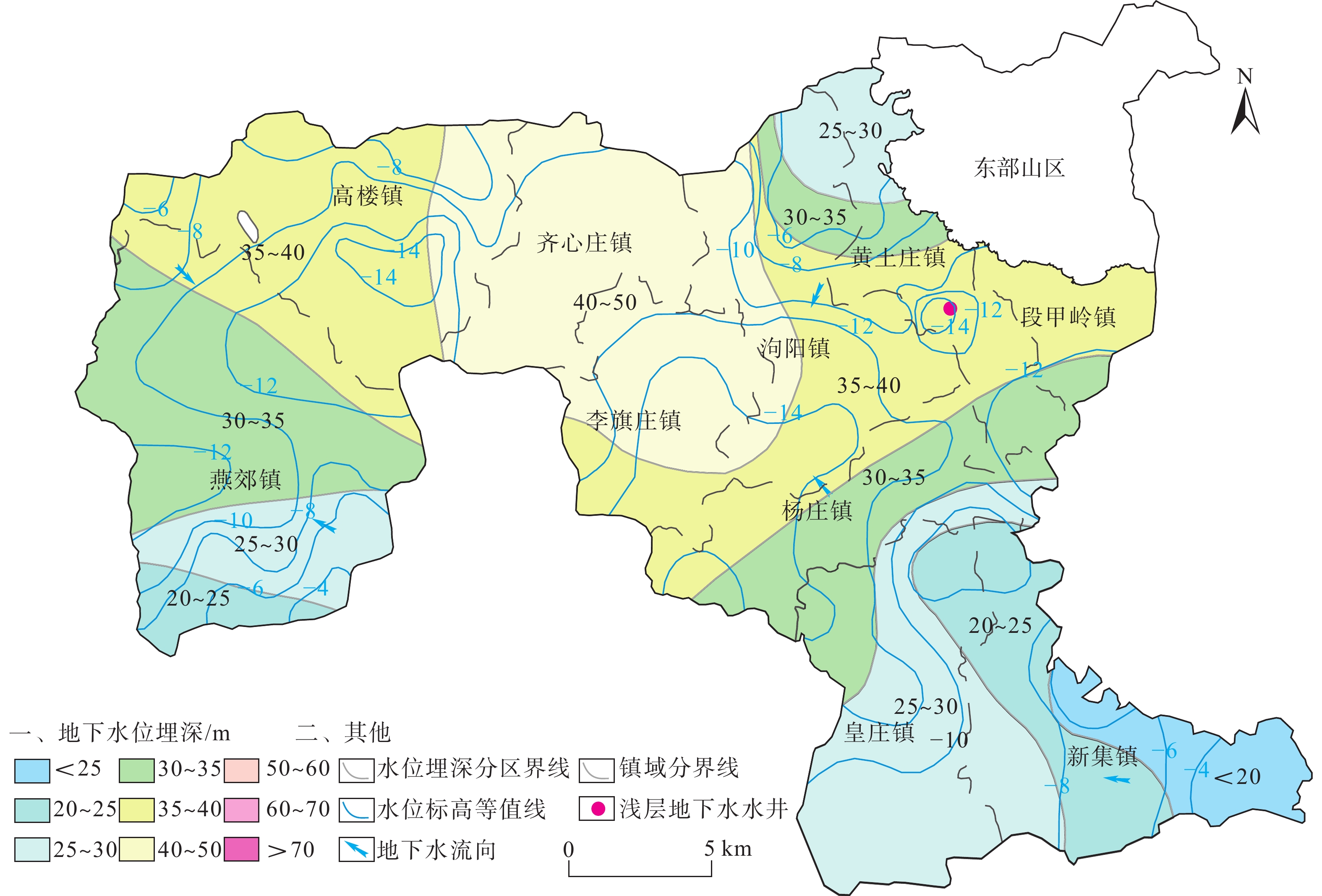
表 1 2016年三河市各乡镇地下水开发利用简表Table 1. Summary of groundwater development and utilization invarious townships of Sanhe City in the year 2016乡镇 生活用水 农业用水 工业用水 浅层开采量 深层开采量 基岩开采量 总开采量 深层 基岩 浅层 深层 基岩 燕郊镇 5123.94 0 480.06 1070.57 0 480.06 6194.51 0 6674.57 泃阳镇 513.12 0 961.84 266.94 0 961.84 780.06 0 1741.9 高楼镇 176.48 2945.04 914.79 0 0 914.79 176.48 2945.04 4036.31 齐心庄镇 120.67 18.03 688.09 0 330.46 688.09 120.67 348.49 1157.25 段甲岭镇 63.8 56.11 448.46 0 0 448.46 63.8 56.11 568.37 李旗庄镇 138.7 0 487.69 0 0 487.69 138.7 0 626.39 黄土庄镇 247.11 0 1072.13 0 0 1072.13 247.11 0 1319.24 杨庄镇 202.94 0 696.02 0 0 696.02 202.94 0 898.96 皇庄镇 268.22 0 964.47 0 0 964.47 268.22 0 1232.69 新集镇 328.83 0 1098.45 0 0 1098.45 328.83 0 1427.28 合计 10202.99 7812 1667.97 7812 8521.32 3349.64 19683 注:单位为104 m3。 图5为2020年8月三河市浅层含水层地下水水位等值线和水位埋深图,由图5知2020年三河市浅层地下水水位埋深分布规律:齐心庄镇、李旗庄镇、泃阳镇西部和高楼镇东部地区水位埋深最大,深度超过35 m;高楼镇东北部、段甲岭镇和杨庄镇北部地区水位埋深较大,为30~35 m;燕郊镇中南部、黄土庄镇北部和皇庄镇南部水位埋深较大,为25~30 m;燕郊镇南部和黄土庄镇北部地区水位埋深较小,为20~25 m;新集镇西南部水位埋深最小,深度小于20 m。由水位标高可以看出,整个三河地区形成4个浅层地下水降落漏斗,它们分别分布于燕郊镇中部、高楼镇西北部、齐心庄镇中部、杨庄镇西部地区,浅层地下水流向由漏斗周边向中心汇流。
![]() 图 5 2020年8月三河市浅层含水层地下水水位等值线和水位埋深图Figure 5. Groundwater level contour and buried depth in shallow aquifers in Sanhe City, August 2020
图 5 2020年8月三河市浅层含水层地下水水位等值线和水位埋深图Figure 5. Groundwater level contour and buried depth in shallow aquifers in Sanhe City, August 2020图6为2020年8月三河市深层含水层地下水水位等值线和水位埋深图,图6显示2020年三河市深层地下水水位埋深分布规律:燕郊镇中部区域水位埋深大,为50~70 m,其中燕郊镇代刘庄村一带水位深度超过70 m;燕郊镇南部和高楼镇东北部地区水位埋深为40~50 m;高楼镇东部、齐心庄镇、李旗庄镇西部等地区水位埋深为35~40 m;泃阳镇南部、杨庄镇和皇庄镇北部地区水位埋深为30~35 m;黄土庄镇、段甲岭镇和皇庄镇南部等地区水位埋深较小,为25~30 m;新集镇地区水位埋深最小,埋深小于25m。由水位标高可以看出,整个三河地区形成2个深层地下水降落漏斗,它们分别分布于燕郊镇中部和杨庄镇西部地区,深层地下水流向由周边向漏斗中心汇流。
![]() 图 6 2020年8月三河市深层含水层地下水水位等值线和水位埋深图Figure 6. Groundwater level contour and buried depth map of deep aquifer in Sanhe City, August 2020
图 6 2020年8月三河市深层含水层地下水水位等值线和水位埋深图Figure 6. Groundwater level contour and buried depth map of deep aquifer in Sanhe City, August 2020三河市区内地下水整体呈现自西北向东南的流场特征。其中孤山、三河东部山区等地区作为高地势、岩溶裂隙水区,使其成为区内较稳定的补给区,周边地下水流向以自北向南为主;潮白河、鲍丘河及泃河周边区域,侧向径流补给较为明显。同时,区内存在两个较明显的低洼区,一处位于三河市西部的燕郊城区,另一处区位于三河市东南部的杨庄镇,这一特征与该区域内供水水源地所在位置和主要工农业用水集中区存在很大相关性。
对比图4和图6知,由InSAR监测到的三河市燕郊镇a、b、c区三处沉降漏斗均位于燕郊深层地下水漏斗范围内,说明燕郊镇地面沉降受深层地下水超采及水位下降影响较大;由InSAR监测到的d区沉降漏斗与段甲岭集中供水水源地的空间位置重合,说明d区沉降同样受地下水超采的影响,但该区域地下水位与地面沉降漏斗的关系弱于燕郊镇。三河市从20世纪60年代开始就逐渐形成地下水位降落漏斗,人工大量开采地下水已经成为地下水排泄的主要方式[20]。随着开采量的加大,漏斗区逐渐加大变深,并逐步影响整个大区内的地下水流向,由此可判断深层地下水超采是引起三河市燕郊镇地面沉降的主要原因。罗三明等[6]、周旭等[8]、李海君等[10]也认为地下水超采是引起本区地面沉降的主要原因。
3.3.2 土层性质
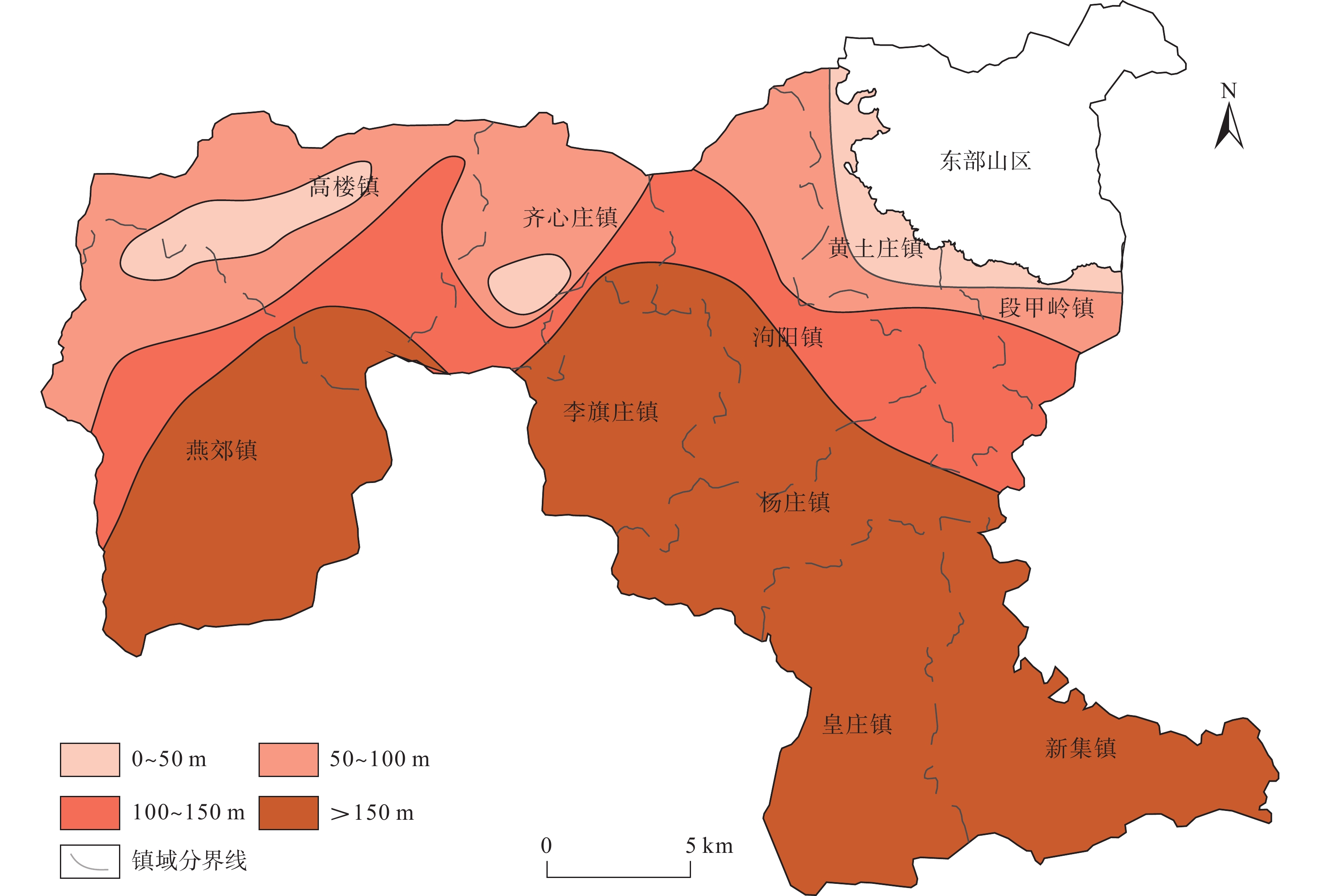
三河市基岩上部土体类型为第四系中更新统、上更新统(Qp)以及全新统(Qh)冲积、冲湖积多层砂、砾石、黏性土、粉砂、细砂为主的多层土体结构类型。多层土体结构既有颗粒较粗、富水性好的砂砾石层,也有颗粒较细、压缩性较高的黏性土层,这类土体类型同时具备可开采的含水层和可沉降的压缩层。三河市第四系厚度总体呈现东西两端薄,中间厚,北薄南厚的的分布特征。以第四系中黏土层总厚度为因素进行统计,对三河市平原区进行工程地质分区。图7为三河市平原区黏土层总厚度分区图,图7显示黏土层总厚度大于150 m的区域主要包括燕郊镇东南部、李旗庄镇、泃阳镇西南部、杨庄镇大部、皇庄镇、新集镇;黏土层总厚度为100~150 m的区域包括燕郊镇中部、高楼镇中部、齐心庄镇南部、泃阳镇中部、黄土庄镇南部、段甲岭镇南部;黏土层总厚度为50~100 m的区域包括燕郊镇西北部、高楼镇西北部、齐心庄镇北部、泃阳镇东北部、黄土庄镇西部、段甲岭镇中部;黏土层总厚度为小于50 m的区域包括燕郊镇北部、高楼镇中部、齐心庄镇中部、黄土庄镇中部、段甲岭镇中部。由InSAR监测到的三处沉降漏斗a、b、c区(图4)均位于黏土层总厚度大于150 m的燕郊镇区域,沉降漏斗d位于黏土层厚度为0~50 m的区域,可见沉降漏斗内黏土层厚度越大发生地面沉降的概率就越大。根据太沙基有效应力原理[21],当含水层中地下水过度开采的时候,相邻黏土层中孔隙水受重力作用流出向含水层补给,导致孔隙水压力降低,从而引起有效应力增加,增加的有效应力则引起土中骨架发生形变即土层压缩变形,其在地表上即呈现出地面下沉的现象[22]。结合燕郊沉降区的黏土层厚度特征,可知当黏土层厚度较大且同时存在地下水过渡开采的情况下,将导致黏土层的释水压缩,引发地面沉降。三河市东南部的杨庄镇、皇庄镇及新集镇虽位于厚黏土层分区,但因不存在地下水超采情况,故未在地表出现地面沉降[23]。此外,除了地下水开采,地表荷载的增加同样会增加土体的有效应力的增加,引起地面沉降。
![]() 图 7 三河市平原区黏土层总厚度分区图Figure 7. Zoning map of total thickness of clay layer in the plain area of Sanhe City
图 7 三河市平原区黏土层总厚度分区图Figure 7. Zoning map of total thickness of clay layer in the plain area of Sanhe City3.3.3 城镇化发展
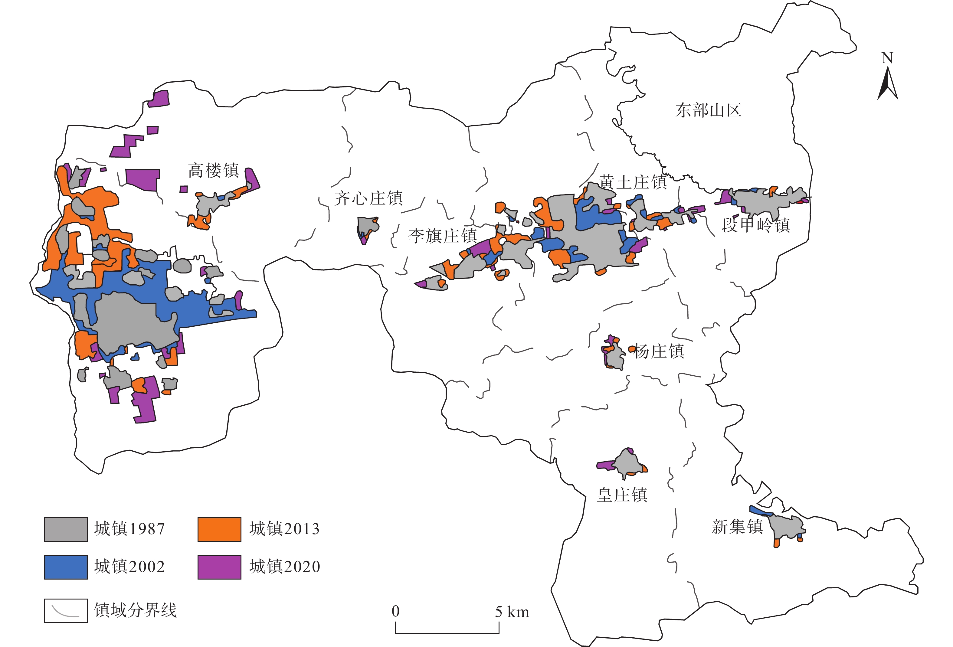
1987—2020年4期的三河市城镇扩张进程图如图8所示,由图知1987—2020年间三河市城镇面积的年平均增长率为3.94%,其中1987—2002年、2002—2014和2014—2020年间三河市城镇面积的增长率分别为38.4%、31.5%、26.5%。燕郊镇城镇面积由1987年的1799 hm增加到2020年4320 hm,增加了2521 hm,平均年增长77 hm,占整个三河市城镇扩张面积的3/4,燕郊镇城镇面积在三河市的比重由2.87%增加到6.78%。对比三河市第七次和第六次全国人口普查常住人口数据知,2020年三河市常住人口较2010年增加了48%,增加的人口中96.5%为外来人口,其余为户籍人口增加。2010—2020年间,燕郊城区常住人口的增加占三河市常住人口增加的96.15%,三河市城区常住人口的增加仅占三河市常住人口增加的10.5%,而其他乡镇的常住人口呈现负增长的特点。由于城镇化面积和人口的快速增长,三河市特别是燕郊镇对水资源的过度开采是造成地面沉降灾害的重要诱因。周旭等[8]、李广宇等[10]也认为城市基础建设、工业用地量和人为活动的加剧对三河市燕郊沉降区地面沉降有显著影响[24 − 25]。
![]() 图 8 1987—2020年三河市城镇扩张进程图Figure 8. Urban expansion process map of in Sanhe City from 1987 to 2020
图 8 1987—2020年三河市城镇扩张进程图Figure 8. Urban expansion process map of in Sanhe City from 1987 to 20204. 结论
(1)通过对比SBAS-InSAR技术监测的地面沉降结果和二等水准成果知,两者平均差值为6.8 mm/a,最小差值为0 mm,均方根误差为8.02 mm,监测精度达到毫米级别,该技术可以满足工作需要。
(2)2018—2020年,三河市地面沉降灾害总体呈现减缓趋势。2018年三河市燕郊镇沉降区内的最大沉降量为−70~−80 mm,段甲岭镇沉降区内的最大沉降量为−60~−70 mm。2020年三河市燕郊镇沉降区内的最大沉降量为−40~−48 mm,段甲岭镇沉降区内的最大沉降量为−40~−47 mm,各沉降量对应的范围也相应减小。三河市地面沉降在空间上呈现西部严重,东部较缓,发育重点沉降区的总体特征。主要有含3个沉降漏斗的燕郊镇沉降区和含1个沉降漏斗的段甲岭镇沉降区,其中燕郊镇沉降区为三河市地面沉降最为严重的区域。
(3)结合三河市地面沉降各诱发因素可得知,三河市地下水的严重超采、土层性质、城镇化发展及人口激增是三河市地面沉降灾害发生及发展的主要因素,尤其以燕郊沉降区最为典型。
-
![]()
图 3 水准测量值与SBAS-InSAR解译值对比图
Figure 3. Comparison between leveling measurement values and SBAS-InSAR interpreted values
![]()
图 4 2018、2019、2020年三河市地面沉降时间序列演化特征
Figure 4. Time-series evolution characteristics of land subsidence in Sanhe City for the years 2018, 2019, and 2020
![]()
图 5 2020年8月三河市浅层含水层地下水水位等值线和水位埋深图
Figure 5. Groundwater level contour and buried depth in shallow aquifers in Sanhe City, August 2020
![]()
图 6 2020年8月三河市深层含水层地下水水位等值线和水位埋深图
Figure 6. Groundwater level contour and buried depth map of deep aquifer in Sanhe City, August 2020
![]()
图 7 三河市平原区黏土层总厚度分区图
Figure 7. Zoning map of total thickness of clay layer in the plain area of Sanhe City
![]()
图 8 1987—2020年三河市城镇扩张进程图
Figure 8. Urban expansion process map of in Sanhe City from 1987 to 2020
表 1 2016年三河市各乡镇地下水开发利用简表
Table 1 Summary of groundwater development and utilization invarious townships of Sanhe City in the year 2016
乡镇 生活用水 农业用水 工业用水 浅层开采量 深层开采量 基岩开采量 总开采量 深层 基岩 浅层 深层 基岩 燕郊镇 5123.94 0 480.06 1070.57 0 480.06 6194.51 0 6674.57 泃阳镇 513.12 0 961.84 266.94 0 961.84 780.06 0 1741.9 高楼镇 176.48 2945.04 914.79 0 0 914.79 176.48 2945.04 4036.31 齐心庄镇 120.67 18.03 688.09 0 330.46 688.09 120.67 348.49 1157.25 段甲岭镇 63.8 56.11 448.46 0 0 448.46 63.8 56.11 568.37 李旗庄镇 138.7 0 487.69 0 0 487.69 138.7 0 626.39 黄土庄镇 247.11 0 1072.13 0 0 1072.13 247.11 0 1319.24 杨庄镇 202.94 0 696.02 0 0 696.02 202.94 0 898.96 皇庄镇 268.22 0 964.47 0 0 964.47 268.22 0 1232.69 新集镇 328.83 0 1098.45 0 0 1098.45 328.83 0 1427.28 合计 10202.99 7812 1667.97 7812 8521.32 3349.64 19683 注:单位为104 m3。  下载: 导出CSV
-
[1] 张拴宏,纪占胜. 合成孔径雷达干涉测量(InSAR)在地面形变监测中的应用[J]. 中国地质灾害与防治学报,2004,15(1):112 − 117. [ZHANG Shuanhong,JI Zhansheng. A review on the application of interferometric synthetic aperture radar on surface deformation monitoring[J]. The Chinese Journal of Geological Hazard and Control,2004,15(1):112 − 117. (in Chinese with English abstract)] DOI: 10.3969/j.issn.1003-8035.2004.01.024 ZHANG Shuanhong, JI Zhansheng. A review on the application of interferometric synthetic aperture radar on surface deformation monitoring[J]. The Chinese Journal of Geological Hazard and Control, 2004, 15(1): 112 − 117. (in Chinese with English abstract) DOI: 10.3969/j.issn.1003-8035.2004.01.024
[2] 许文斌,李志伟,丁晓利,等. 利用InSAR短基线技术估计洛杉矶地区的地表时序形变和含水层参数[J]. 地球物理学报,2012,55(2):452 − 461. [XU Wenbin,LI Zhiwei,DING Xiaoli,et al. Application of small baseline subsets D-InSAR technology to estimate the time series land deformation and aquifer storage coefficients of LosAngeles area[J]. Chinese Journal of Geophysics,2012,55(2):452 − 461. (in Chinese with English abstract)] DOI: 10.6038/j.issn.0001-5733.2012.02.009 XU Wenbin, LI Zhiwei, DING Xiaoli, et al. Application of small baseline subsets D-InSAR technology to estimate the time series land deformation and aquifer storage coefficients of LosAngeles area[J]. Chinese Journal of Geophysics, 2012, 55(2): 452 − 461. (in Chinese with English abstract) DOI: 10.6038/j.issn.0001-5733.2012.02.009
[3] GABRIEL A K,GOLDSTEIN R M,ZEBKER H A. Mapping small elevation changes over large areas:Differential radar interferometry[J]. Journal of Geophysical Research:Solid Earth,1989,94(B7):9183 − 9191. DOI: 10.1029/JB094iB07p09183
[4] FERRETTI A,PRATI C,ROCCA F. Permanent scatterers in SAR interferometry[J]. IEEE Transactions on Geoscience and Remote Sensing,2001,39(1):8 − 20. DOI: 10.1109/36.898661
[5] BERARDINO P,FORNARO G,LANARI R,et al. A new algorithm for surface deformation monitoring based on small baseline differential SAR interferograms[J]. IEEE Transactions on Geoscience and Remote Sensing,2002,40(11):2375 − 2383. DOI: 10.1109/TGRS.2002.803792
[6] 罗三明,杜凯夫,畅柳,等. 基于PS-InSAR方法反演北京地区地表沉降速率[J]. 大地测量与地球动力学,2014,34(1):43 − 46. [LUO Sanming,DU Kaifu,CHANG Liu,et al. Ground subsidence rates of Beijing area inversed by PS-InSAR analysis[J]. Journal of Geodesy and Geodynamics,2014,34(1):43 − 46. (in Chinese with English abstract)] DOI: 10.14075/j.jgg.2014.01.024 LUO Sanming, DU Kaifu, CHANG Liu, et al. Ground subsidence rates of Beijing area inversed by PS-InSAR analysis[J]. Journal of Geodesy and Geodynamics, 2014, 34(1): 43 − 46. (in Chinese with English abstract) DOI: 10.14075/j.jgg.2014.01.024
[7] 郭海朋,白晋斌,张有全,等. 华北平原典型地段地面沉降演化特征与机理研究[J]. 中国地质,2017,44(6):1115 − 1127. [GUO Haipeng,BAI Jinbin,ZHANG Youquan,et al. The evolution characteristics and mechanism of the land subsidence in typical areas of the north China Plain[J]. Geology in China,2017,44(6):1115 − 1127. (in Chinese with English abstract)] DOI: 10.12029/gc20170606 GUO Haipeng, BAI Jinbin, ZHANG Youquan, et al. The evolution characteristics and mechanism of the land subsidence in typical areas of the north China Plain[J]. Geology in China, 2017, 44(6): 1115 − 1127. (in Chinese with English abstract) DOI: 10.12029/gc20170606
[8] 周旭,许才军,温扬茂. 利用时序InSAR技术分析北京及河北廊坊地面沉降[J]. 测绘科学,2017,42(7):89 − 93. [ZHOU Xu,XU Caijun,WEN Yangmao. Land subsidence monitoring of Beijing and Langfang of Hebei Prouince by time series InSAR[J]. Science of Surveying and Mapping,2017,42(7):89 − 93. (in Chinese with English abstract)] DOI: 10.16251/j.cnki.1009-2307.2017.07.015 ZHOU Xu, XU Caijun, WEN Yangmao. Land subsidence monitoring of Beijing and Langfang of Hebei Prouince by time series InSAR[J]. Science of Surveying and Mapping, 2017, 42(7): 89 − 93. (in Chinese with English abstract) DOI: 10.16251/j.cnki.1009-2307.2017.07.015
[9] 李海君,张耀文,杨月巧,等. 廊坊北三县地区地面沉降时空分布特征与成因分析[J]. 科学技术与工程,2018,18(11):23 − 30. [LI Haijun,ZHANG Yaowen,YANG Yueqiao,et al. Spatial-temporal distribution characteristics and causation analysis of land subsidence in three northern counties area of Langfang[J]. Science Technology and Engineering,2018,18(11):23 − 30. (in Chinese with English abstract)] DOI: 10.3969/j.issn.1671-1815.2018.11.003 LI Haijun, ZHANG Yaowen, YANG Yueqiao, et al. Spatial-temporal distribution characteristics and causation analysis of land subsidence in three northern counties area of Langfang[J]. Science Technology and Engineering, 2018, 18(11): 23 − 30. (in Chinese with English abstract) DOI: 10.3969/j.issn.1671-1815.2018.11.003
[10] 李广宇,张瑞,刘国祥,等. Sentinel-1A TS-DInSAR京津冀地区沉降监测与分析[J]. 遥感学报,2018,22(4):633 − 646. [LI Guangyu,ZHANG Rui,LIU Guoxiang,et al. Land subsidence detection and analysis over Beijing-Tianjin-Hebei area based on Sentinel-1A TS-DInSAR[J]. Journal of Remote Sensing,2018,22(4):633 − 646. (in Chinese with English abstract)] LI Guangyu, ZHANG Rui, LIU Guoxiang, et al. Land subsidence detection and analysis over Beijing-Tianjin-Hebei area based on Sentinel-1A TS-DInSAR[J]. Journal of Remote Sensing, 2018, 22(4): 633 − 646. (in Chinese with English abstract)
[11] 刘毅. 地面沉降研究的新进展与面临的新问题[J]. 地学前缘,2001,8(2):273 − 278. [LIU Yi. Land subsidence research approaches and advent problems[J]. Earth Science Frontiers,2001,8(2):273 − 278. (in Chinese with English abstract)] DOI: 10.3321/j.issn:1005-2321.2001.02.009 LIU Yi. Land subsidence research approaches and advent problems[J]. Earth Science Frontiers, 2001, 8(2): 273 − 278. (in Chinese with English abstract) DOI: 10.3321/j.issn:1005-2321.2001.02.009
[12] 葛伟丽,李元杰,张春明,等. 基于InSAR技术的内蒙古巴彦淖尔市地面沉降演化特征及成因分析[J]. 水文地质工程地质,2022,49(4):198 − 206. [GE Weili, LI Yuanjie, ZHANG Chunming, et al. An attribution analysis of land subsidence features in the city of Bayannur in Inner Mongolia based on InSAR[J]. Hydrogeology & Engineering Geology,2022,49(4):198 − 206. (in Chinese with English abstract)] GE Weili, LI Yuanjie, ZHANG Chunming, et al. An attribution analysis of land subsidence features in the city of Bayannur in Inner Mongolia based on InSAR[J]. Hydrogeology & Engineering Geology, 2022, 49(4): 198 − 206. (in Chinese with English abstract)
[13] 何庆成,刘文波,李志明. 华北平原地面沉降调查与监测[J]. 高校地质学报,2006,12(2):195 − 209. [HE Qingcheng,LIU Wenbo,LI Zhiming. Investigation and monitoring of land subsidence in north China Plain[J]. Geological Journal of China Universities,2006,12(2):195 − 209. (in Chinese)] DOI: 10.3969/j.issn.1006-7493.2006.02.006 HE Qingcheng, LIU Wenbo, LI Zhiming. Investigation and monitoring of land subsidence in north China Plain[J]. Geological Journal of China Universities, 2006, 12(2): 195 − 209. (in Chinese) DOI: 10.3969/j.issn.1006-7493.2006.02.006
[14] 侯安业,张景发,刘斌,等. PS-InSAR与SBAS-InSAR监测地表沉降的比较研究[J]. 大地测量与地球动力学,2012,32(4):125 − 128. [HOU Anye,ZHANG Jingfa,LIU Bin,et al. Comparative study on monitoring surface subsidence with PS-InSAR and SBAS-InSAR[J]. Journal of Geodesy and Geodynamics,2012,32(4):125 − 128. (in Chinese with English abstract)] DOI: 10.3969/j.issn.1671-5942.2012.04.029 HOU Anye, ZHANG Jingfa, LIU Bin, et al. Comparative study on monitoring surface subsidence with PS-InSAR and SBAS-InSAR[J]. Journal of Geodesy and Geodynamics, 2012, 32(4): 125 − 128. (in Chinese with English abstract) DOI: 10.3969/j.issn.1671-5942.2012.04.029
[15] MASSONNET D,HOLZER T,VADON H. Land subsidence caused by the East Mesa Geothermal Field,California,observed using SAR interferometry[J]. Geophysical Research Letters,1997,24(8):901 − 904. DOI: 10.1029/97GL00817
[16] 张凯翔,张占荣,于宪煜. SBAS-InSAR和PS-InSAR技术在鲁西南某线性工程沿线地面沉降成因分析中的应用[J]. 中国地质灾害与防治学报,2022,33(4):65 − 76. [ZHANG Kaixiang,ZHANG Zhanrong,YU Xianyu. Application of SBAS-InSAR and PS-InSAR technologies in analysis of landslide subsidence along a linear infrastructure in southwestern Shandong[J]. The Chinese Journal of Geological Hazard and Control,2022,33(4):65 − 76. (in Chinese with English abstract)] ZHANG Kaixiang, ZHANG Zhanrong, YU Xianyu. Application of SBAS-InSAR and PS-InSAR technologies in analysis of landslide subsidence along a linear infrastructure in southwestern Shandong[J]. The Chinese Journal of Geological Hazard and Control, 2022, 33(4): 65 − 76. (in Chinese with English abstract)
[17] 张进才,沈荣辉,褚立峰. 河北平原地面沉降监测网络体系建设[R]. 中国地质学会,2006. [ZHANG Jincai,SHEN Ronghui,CHU Lifeng. Construction of land subsidence monitoring network system in Hebei Plain[R]. Geological Society of China,2006 .(in Chinese)] ZHANG Jincai, SHEN Ronghui, CHU Lifeng. Construction of land subsidence monitoring network system in Hebei Plain[R]. Geological Society of China, 2006 .(in Chinese)
[18] 戴真印,刘岳霖,张丽平,等. 基于改进时序InSAR技术的东莞地面沉降时空演变特征[J]. 中国地质灾害与防治学报,2023,34(1):58 − 67. [DAI Zhenyin,LIU Yuelin,ZHANG Liping,et al. Spatial-temporal evolution characteristics of land subsidence in Dongguan City based on improved InSAR technology[J]. The Chinese Journal of Geological Hazard and Control,2023,34(1):58 − 67. (in Chinese with English abstract)] DAI Zhenyin, LIU Yuelin, ZHANG Liping, et al. Spatial-temporal evolution characteristics of land subsidence in Dongguan City based on improved InSAR technology[J]. The Chinese Journal of Geological Hazard and Control, 2023, 34(1): 58 − 67. (in Chinese with English abstract)
[19] 刘贺, 罗勇, 雷坤超, 等. 北京新航城地区地面沉降演化规律及多源监测方法对比研究[J]. 地质科技通报,2023,42(1):398 − 406. [LIU He, LUO Yong, LEI Kunchao, et al. Evolution of land subsidence and comparative study on multi-source monitoring methods in New Airlines City of Beijing[J]. Bulletin of Geological Science and Technology,2023,42(1):398 − 406. (in Chinese with English abstract)] LIU He, LUO Yong, LEI Kunchao, et al. Evolution of land subsidence and comparative study on multi-source monitoring methods in New Airlines City of Beijing[J]. Bulletin of Geological Science and Technology, 2023, 42(1): 398 − 406. (in Chinese with English abstract)
[20] 程蕊, 朱琳, 周佳慧, 等. 北京潮白河冲洪积扇地面沉降时空异质性特征及驱动因素分析[J]. 吉林大学学报(地球科学版),2021,51(4):1182 − 1192. [CHENG Rui, ZHU Lin, ZHOU Jiahui, et al. Spatio-temporal heterogeneity and driving factors of land subsidence in middle-lower part of Chaobai River alluvial fan[J]. Journal of Jilin University(Earth Science Edition),2021,51(4):1182 − 1192. (in Chinese with English abstract)] CHENG Rui, ZHU Lin, ZHOU Jiahui, et al. Spatio-temporal heterogeneity and driving factors of land subsidence in middle-lower part of Chaobai River alluvial fan[J]. Journal of Jilin University(Earth Science Edition), 2021, 51(4): 1182 − 1192. (in Chinese with English abstract)
[21] 成建梅, 柳璨, 李敏敏, 等. 城市化进程下北京平原渗流场与地面沉降发展演化模拟[J]. 地质科技通报,2020,39(1):43 − 52. [CHENG Jianmei, LIU Can, LI Minmin, et al. Numerical study on evolution of groundwater hydrodynamics and land subsidence under the process of metropolitan urbanization in Beijing Plain, China[J]. Bulletin of Geological Science and Technology,2020,39(1):43 − 52. (in Chinese with English abstract)] CHENG Jianmei, LIU Can, LI Minmin, et al. Numerical study on evolution of groundwater hydrodynamics and land subsidence under the process of metropolitan urbanization in Beijing Plain, China[J]. Bulletin of Geological Science and Technology, 2020, 39(1): 43 − 52. (in Chinese with English abstract)
[22] 狄胜同. 地下水开采导致地面沉降全过程宏细观演化机理及趋势预测研究[D]. 济南:山东大学,2020. [DI Shengtong. Study on macro-meso evolution mechanism and trend prediction of land subsidence caused by groundwater exploitation in the whole process[D]. Jinan:Shandong University,2020. (in Chinese with English abstract)] DI Shengtong. Study on macro-meso evolution mechanism and trend prediction of land subsidence caused by groundwater exploitation in the whole process[D]. Jinan: Shandong University, 2020. (in Chinese with English abstract)
[23] 王云龙,陈晔,郭海朋,等. 沧州地区土层固结特征与地面沉降临界水位研究[J]. 水文地质工程地质,2023,50(4):185 − 192. [WANG Yunlong, CHEN Ye, GUO Haipeng, et al. A study of the critical groundwater level related to soil consolidation characteristics of land subsidence in Cangzhou[J]. Hydrogeology & Engineering Geology,2023,50(4):185 − 192. (in Chinese with English abstract)] WANG Yunlong, CHEN Ye, GUO Haipeng, et al. A study of the critical groundwater level related to soil consolidation characteristics of land subsidence in Cangzhou[J]. Hydrogeology & Engineering Geology, 2023, 50(4): 185 − 192. (in Chinese with English abstract)
[24] 殷跃平,张作辰,张开军. 我国地面沉降现状及防治对策研究[J]. 中国地质灾害与防治学报,2005,16(2):1 − 8. [YIN Yueping,ZHANG Zuochen,ZHANG Kaijun. Land subsidence and countermeasures for its prevention in China[J]. The Chinese Journal of Geological Hazard and Control,2005,16(2):1 − 8. (in Chinese with English abstract)] DOI: 10.3969/j.issn.1003-8035.2005.02.001 YIN Yueping, ZHANG Zuochen, ZHANG Kaijun. Land subsidence and countermeasures for its prevention in China[J]. The Chinese Journal of Geological Hazard and Control, 2005, 16(2): 1 − 8. (in Chinese with English abstract) DOI: 10.3969/j.issn.1003-8035.2005.02.001
[25] 张田田, 杨为民, 万飞鹏. 浑河断裂带地质灾害发育特征及其成因机制[J]. 吉林大学学报(地球科学版),2022,52(1):149 − 161. [ZHANG Tiantian, YANG Weimin, WAN Feipeng. Characteristics and formation mechanism of geohazards in Hunhe fault zone[J]. Journal of Jilin University (Earth Science Edition),2022,52(1):149 − 161. (in Chinese with English abstract)] ZHANG Tiantian, YANG Weimin, WAN Feipeng. Characteristics and formation mechanism of geohazards in Hunhe fault zone[J]. Journal of Jilin University (Earth Science Edition), 2022, 52(1): 149 − 161. (in Chinese with English abstract)


计量
- 文章访问数: 738
- HTML全文浏览量: 99
- PDF下载量: 130
 邮件订阅
邮件订阅 RSS
RSS