

Analysis of bank slope stability under strong seismic response for super long span bridges
-
摘要:
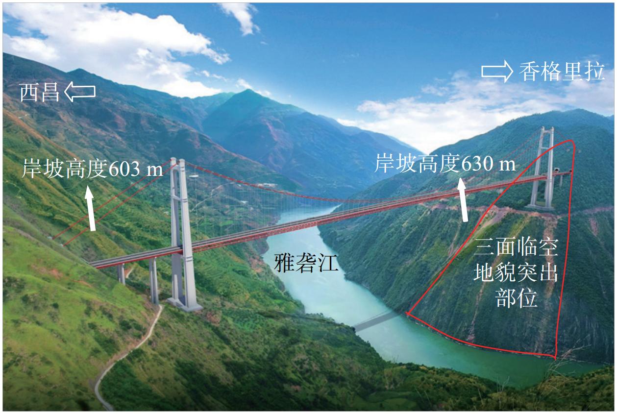
在高烈度山区设计修建公路桥梁时,耦合多种不利条件的在强震作用下超大跨径桥梁高陡岸坡稳定性最为复杂,易形成滑移、碎屑流等岸坡失稳灾害。实际震害调查结果表明不规则地形对地震动力具有明显的放大作用,对边坡的稳定性和桥梁的安全性构成不利的影响,如何考虑复杂地形的地震动力放大效应具有重要的工程价值。以位于四川省凉山彝族自治州高烈度深切峡谷地段的主跨
1200 m特大悬索桥岸坡为例,对此类超大跨径桥梁岸坡在强地震力作用下的基岩面地震危险性概率和失稳破坏模式机理进行研究,建立了含卸荷裂隙的三维坡体结构模型,采用动力时程分析方法给出了不同失稳破坏模式下岸坡上各特征点的峰值地震加速度并据此获得了修正的放大系数。基于修正的放大系数对坡体地震稳定性的拟静力计算方法进行改进,采用改进后的方法对该桥位的稳定性进行了评估。结果表明:边坡遵循峰值地震水平加速度及放大系数地表最大,随着坡体深度的增大而递减,且递减速度减缓并趋于稳定的规律,且坡度变化率对此影响极大。坡度变化率大且地貌突出部位的地震响应极为强烈。大范围分布的碎块石土覆盖层、变坡率的地貌突出的浅表层、风化卸荷带内的表层风化碎裂岩体极易在地震作用下产生变形,应当加强防护。未考虑修正放大系数的地震工况计算结果偏于不安全,安全系数的计算结果减少了2%~6%。据此提出一整套针对高烈度山区特大跨径桥梁岸坡的地质灾害风险评估方法和与考虑桥梁结构两水准抗震相适应的边坡稳定性计算方法及防护措施建议思路,为相关工程的研究与设计提供参考。Abstract:Designing and constructing highway bridges in high-intensity mountainous areas present significant challenges. The stability of high and steep bank slopes for large span bridges coupled with various unfavorable conditions under strong earthquakes is particularly complex, which is prone to formation of bank slope instability disasters such as sliding and debris flow. Investigations into earthquake damage reveal that irregular terrain has a significant amplification effect on earthquake dynamics, which has an adverse impact on the stability of slopes and the safety of bridges. Assessing the seismic dynamic amplification effect of complex terrain is of important engineering value. This study examines the bank slope of a 1200m-long suspension bridge located in the high-intensity, deep canyon region of the Liangshan Yi Autonomous Prefecture, Sichuan Province. We conduct an in-depth analysis and research on the seismic hazard probability and instability failure mode mechanisms of the bedrock surface under strong seismic forces. A three-dimensional slope structure model with unloading cracks was developed. The peak seismic acceleration of each characteristic point on the bank slope under different instability failure modes was obtained using dynamic time-history analysis method and modified amplification coefficient was derived based on these findings. Improvements were made to the static calculation method for slope seismic stability using this modified coefficient. The improved method was used to evaluate the stability of the construction site. The results indicate that the slope's peak seismic horizontal acceleration and amplification coefficient are highest at the surface and decrease with increasing slope depth, with the rate of decrease slowing and stabilizing. The rate of slope change significantly impacts this response. The seismic response is exceptionally strong in areas with high slope change rates and prominent landforms. Widely distributed fragmented rock and soil cover layers, shallow surfaces with varying slope rates, and surface weathered fragmented rock masses within weathering unloading zones are prone to deformation under seismic action, and protection should be strengthened. The calculation results of seismic conditions without considering the correction of amplification factors are unsafe, with safety factor results decreasing by 2% to 6%. A complete set of geological hazard risk assessment methods, and slope stability calculation methods, and protective measures suitable for considering the two-level seismic resistance of bridge structures are proposed based on this for the bank slopes of ultra large span bridges in high intensity mountainous areas, providing a reference for the research and design of related engineering projects in high-intensity mountainous areas.
-
0. 引言
近年来,呼和浩特市经济发展迅速,主城区人口快速增长,城市建设及工业建设用地等持续增加。2005年之前,地下水水源为呼和浩特市区唯一水源[1]。2006年以后,“引黄入呼”工程引黄河水10×104 m3/d。城市供水可开采量 25. 8×10⁴ m3/d,但是需水量高达49.1×104 m3/ d[2],需水量差额从地下抽取,导致近十多年来地下水位年均下降1.7 m,市城南地面相比于10多年前沉降了约10 cm[3]。
21世纪初至今,PS-InSAR技术在地表沉降监测方面取得许多成果[4]。张剑[5]基于Sentinel-1数据,运用PS-InSAR技术监测得到兰州市中心城区的年均形变速率和时序上的累计沉降量,总结了该地区的沉降规律,并结合兰州市的工程施工项目和黄土湿陷等资料分析了地面沉降原因。廖明生等[6]利用PS-InSAR技术对上海市进行地面沉降监测,得到各时期的沉降速率,并与同时期水准数据对比验证,结果达到毫米级精度。同时基于时间序列高分辨率SAR影像还能够监测大型单体建筑物及地铁等线状地物,说明了PS-InSAR技术的应用潜力与有效性。马秀露[7]利用2015—2018年间的36景Sentinel-1A影像,采用PS-InSAR技术监测了西安高铁北站附近地区,得到郑西高铁西安段及周边区域的沉降速率,并对结果进行详细分析。郑佳兵等[8]基于北京平原区的PS-InSAR时序监测,构建北京平原区沉降数据,道路交通影响区占总沉降区87.81%,定量分析了道路交通对该区沉降的影响,得出道路交通是沉降的主要因素之一,并且是引起北京平原区沉降外因的结论。张勤等[9]通过总结InSAR等技术的特点及应用,总结并展望高精度空间监测技术融合,认为PS-InSAR技术提高了InSAR形变监测的精度。众多研究表明PS-InSAR方法对微小形变有着较高的敏感度,能够提高监测沉降的精度[10]。
呼和浩特市发展迅速,城市建筑工程活动加剧,地下水的进一步开采对地面稳定性造成持续性破坏[11],该市地面沉降需要给予特别关注。林凯[12]对呼和浩特市地铁1号线呼钢东站主体建设工程变形监测数据进行了模型对比分析,研究发现卡尔曼滤波-BP神经网络组合模型相比于单一模型的预测精度提高了30%,稳定性更好,通过对28个地铁墙顶竖向位移点进行30期的观测,其中累计沉降量最大值16.52 mm。胡勇平[13]对呼和浩特市回民区万达广场变形进行了预测分析,通过建立六种模型发现基坑从开挖、浇筑直到回填整体变形处于稳定状态。张凯等[14]对呼和浩特轨道交通2号线某车站基坑开挖进行了沉降监测分析,发现各监测点监测值均在可控范围之内,其中围护结构总体变形较大。杨红樱等[15]研究了降雨对呼和浩特地震台形变观测的影响。
以上研究仅局限于局部形变监测,未开展呼和浩特城区整体的沉降监测。文章以呼和浩特市城区为研究对象,采用PS-InSAR技术进行地面沉降监测分析,提取呼和浩特市城区地面沉降信息,以期对城市安全提供相关分析。
1. 研究区与数据
1.1 研究区概况
(1)地理位置。研究区地处大青山山脉南部,南抵大黑河,西到内蒙古医科大学(金川校区),东至大黑河,面积约694 km2。研究区地理位置如图1所示。
(2)地形地貌。研究区位于土默川平原,地貌属于大青山山前冲洪积倾斜平原[16],地势北高南低[17]。向东部和北部地势逐渐增高,向西部和南部地势逐渐降低。
(3)水文条件。该区域河流为黄河水系,是主要饮用水来源,地表水资源多在雨季6—8月,含沙多、峰大量小、时令性强[18]。市区在近20—30年开始大规模开采地下水,开发利用程度较高[19]。
(4)第四系土层性质及分布简述。由中国地质调查局发展研究中心K-49-28呼和浩特市幅1∶20万区域地质图空间数据库(https://geocloud.cgs.gov.cn/#/home)可知,研究区地层以第四系为主,是大青山山前凹陷地带,地表出露大部分为全新统,次为更新统。其中冲积层(
研究区第四纪地层环境特征详见张恒星[20]第二章。地质剖面图参考李潇瀚等[21]图1与图2、张泽鹏等[22]图1、赵瑞科等[23]图1、石鸿蕾等[24]图1的呼和浩特城区部分。研究区第四纪地质略图见张翼龙[25]图2—5。
1.2 数据来源
本次试验时间为2017年3月—2021年4月,选取了覆盖呼和浩特市城区25景Sentinel-1A升轨影像,影像信息详见表1,VV极化方式,IW成像模式。选取2018-10-04期为超级主影像,计算24景影像与超级主影像的时空基线(图2)。时序数据空间基线最大为2019年12月10期的87.43 m,最短为2021年4月3期的5.72 m,满足试验需求[11]。
表 1 研究所采用的Sentinel-1A数据参数Table 1. Summary of the Sentinel-1A data parameters used in the study影像编号 成像日期 空间基线距/m 时间基线距/d 影像编号 成像日期 空间基线距/m 时间基线距/d 1 2017-03-19 −34.87 −564 14 2019-04-02 −28.33 180 2 2017-04-12 −37.39 −540 15 2019-06-01 −23.04 240 3 2017-06-11 26.72 −480 16 2019-08-12 −78.11 312 4 2017-07-29 −40.10 −432 17 2019-10-11 53.56 372 5 2017-10-09 −33.23 −360 18 2019-12-10 87.43 432 6 2017-12-08 45.08 −300 19 2020-02-08 62.98 492 7 2018-02-06 −31.88 −240 20 2020-04-08 63.07 552 8 2018-04-07 12.50 −180 21 2020-05-14 −30.41 588 9 2018-06-06 −22.68 −120 22 2020-08-06 29.23 672 10 2018-08-05 −18.48 −60 23 2020-10-05 −33.29 732 11 2018-10-04 0.00 0 24 2020-12-04 23.03 792 12 2018-12-03 48.10 60 25 2021-04-03 5.72 912 13 2019-02-01 45.28 120 2. 数据处理
2.1 PS-InSAR原理简介
PS-InSAR从所有覆盖在同一地区的多景时序InSAR影像,基于时空基线,选择一幅为超级主影像,其余的作为辅影像,与主影像进行配准处理,根据影像在时间序列上的幅度与相位信息的稳定性,获得很多相关性、稳定性高的点;再剔除地形相位与干涉处理,提取带有永久散射体目标信息的差分干涉相位,二次差分相邻目标的差分干涉相位;最后建立起基于两次差分后形变相位模型,求解形变相位、分离大气延迟相位,得出研究区的形变信息与地形残余信息[26]。
Ferretti等 于1999年提出了PS-InSAR技术,通过对同一区域的多时相雷达影像,进行时空基线的综合评估,选出超级主影像,其余作为副影像,配准主副影像,同时生成干涉图[27],则干涉相位由式(1)表示:
(1) 式中:
(2) 将式(2)带入式(1)整理后得式(3):
(3) 式中:
则对第N景干涉图PS点的干涉相位整理得式(4):
(4) 2.2 数据处理
数据处理使用由美国Exelis Visual Information Solutions公司开发的ENVI(The environment for visualizing images)遥感图像处理平台下的SARscape高级雷达处理模块[29]。对Sentinel-1A影像数据进行数据导入,研究区裁剪,连接图生成(时空基线分布如图2所示),干涉工作流(包括配准、干涉图生成、去平、振幅离差指数计算),PS两次模型反演,地理编码。选用30 m格网间隔的SRTM DEM去除地形相位[30]。
3. 结果与分析
3.1 地面沉降分布
通过InSAR时序处理,分别获得2017年3月—2021年4月呼和浩特市城区累计沉降量和平均沉降速率(软件自动选择和分配)。从研究区整体来看,研究区西部沉降量明显大于东部,沉降较为严重区域集中分布在回民区与玉泉区交界处,金川开发区。呼和浩特市累计沉降量最大沉降为194.80 mm,研究区平均累计沉降值为15.50 mm(图3)。最大平均沉降速率为49.27 mm/a,研究区平均沉降速率的平均值为3.65 mm/a(图4—5)。
![]() 图 3 呼和浩特市2017—2021年地表累计形变量Figure 3. Cumulative surface settlement of Hohhot City from 2017 to 2021
图 3 呼和浩特市2017—2021年地表累计形变量Figure 3. Cumulative surface settlement of Hohhot City from 2017 to 2021![]() 图 4 2017—2021年研究区平均形变速率图Figure 4. Average settlement rate of the study area from 2017 to 2021
图 4 2017—2021年研究区平均形变速率图Figure 4. Average settlement rate of the study area from 2017 to 20213.2 沉降原因分析
结果表明,研究时间段内研究区总体呈现下沉趋势,且有较为严重的沉降区。这与文献[31-33]对该市的沉降研究趋势是相同的,呼和浩特垂直形变速率图详见文献[32]中图6。文献[32]认为漏斗沉降区域的生成是地下水的过度开采所致,其中文献[1、17、29]发现该地区地下水位多年来持续下降。
![]() 图 6 实地调查照片Figure 6. Field photos of concrete building cracks due to ground settlement
图 6 实地调查照片Figure 6. Field photos of concrete building cracks due to ground settlement分别用A—E作为标识的5个代表区域,标识位置见图3,并对5个沉降中心进行了实地调研,将造成呼和浩特市城区较大沉降的主要因素分为两类:地下水开采和人工建造两个层面进行分析。
A沉降区主要包括地铁1号线坝堰(机场)站、白塔西站、什兰岱站和呼和浩特白塔国际机场。该区是研究区东部沉降较为严重的区域,最大沉降速率18.15 mm/a,平均沉降速率3.06 mm/a(图5)。该区沉降原因是由于在地铁等地面建筑物施工过程中,对地下水抽取,同时地下水抽取过多使得地表受力不均衡,因此产生沉降。在工程完期后,由于土体的自固结也会导致沉降的可能,增加地面沉降的不确定因素[33]。A区是研究区重要的交通运输枢纽,该区域人流量大,建筑密集。为保障地铁1号线和机场的运营安全,应持续监测该地区沉降和加强地基的维护,以减缓地表差异形变对地铁和机场运营的影响。
E区主要以加工场、小区居多,人口数量大。其沉降中心集中在工业区和新建建筑附近,向四周沉降逐渐减小,形成一个漏斗沉降区,道路塌陷情况严重,墙体存在开裂现象(图6)。该区域为五个研究区最大形变区域,最大沉降速率43.72 mm/a,平均沉降速率12.46 mm/a。该地区沉降原因是由于地下水超采。其原因由文献[34-36]佐证:台阁牧镇附近的水头下降速率超过2.0 m/a,属于严重超采区,地下水超采区位置详见文献[34]图2、文献[35]附图1,其评价结果与地下水开采程度及水头的变化情况基本一致,具有可靠性[34]。
B、C、D沉降区分别位于西乌素图回迁小区周围、回民区南部城发绿园小区及广龙苑小区周围、玉泉区北部丽和阳光城及西岸国际小区周围。B区最大沉降量111.70 mm,平均沉降量36.34 mm;C区最大沉降量99.2 mm,平均沉降量41.07mm;D区最大沉降量111.30 mm,平均沉降量50.99 mm,其中D区平均沉降量为最大。3个沉降区分别以各自为最大沉降量中心向四周呈递减趋势,且D区和C区有连片趋势。经过实地考察以及遥感影像分析,相比于周围区域,3个沉降区高层居民楼、学区房等建筑物荷载较多,从而加重地表沉降,且根据中国科学院资源环境科学数据中心提供的中国土壤质地空间分布数据可知,呼和浩特市的土壤质地以砂土为主,占比40%~60%,粉砂土占比20%~40%,表明呼和浩特市土壤质地松散,不利于储水。同时在建筑物等地上设施建设过程中容易导致松散的土壤被压实,发生地面沉降,与文献[37]分析一致。
4. 精度验证
此次研究有5个地铁控制网二等精密水准测量数据来验证精度。
后不塔气站监测日期在2017年4月—2018年7月,期间道路地表竖向位移测点最终累计变形值介于−12.2~13.0 mm,整体呈下沉变化,Sentinel-1A影像InSAR结果显示在后不塔气地铁站形变值介于−12.1~12.9 mm之间。
将军衙署站在监测日期在2017年3月—2018年6月,共观测27次。地表监测累计量介于−7.36~5 mm。Sentinel-1A影像InSAR结果显示形变值介于−10~6.6 mm。
其他三个站(内蒙古展览馆站、西龙王庙站、西二环路站)Sentinel-1A影像InSAR形变结果均在地表监测形变范围之内误差最大为24.7 mm,大部分误差保持在5 mm以内。以上结果说明两者结果保持了较好的一致性。
误差较大的原因主要为水准测量获取的“点”形变信息,PS-InSAR获取的是一个分辨单元的沉降量,属于“面”形变信息。Sentinel-1A影像分辨率是5 m×20 m,PS-InSAR中“面”的形变受其附近5~20 m区域的影响,还受到散射特性强的地面反射物影响,PS-InSAR和水准测量结果的比较是“面”和“点”结果的比较[38],所以二者不能完全对应,存在误差。其次为研究区部分地区地形起伏大,存在地形残差[39-41]。
5. 结论
本文阐述了运用25景覆盖呼和浩特市城区的Sentinel-1A升轨SAR影像和PS-InSAR技术,提取城区整体地表形变情况,并分析了影响因素。研究结果表明:
(1)Sentinel-1A数据影像数量足,回访周期短,利于InSAR时序分析提取城区地表形变分析结果,服务于城市安全监测。
(2)在监测时间段内,呼和浩特市地表呈现出整体较大范围的下沉,其中西侧沉降量大于东侧。文中共识别出5个显著沉降漏斗,主要原因为地下水超采和人类活动。总结出的显著沉降区下沉原因,与已有文献结果比较,沉降分布规律以及相对位置基本吻合,对呼和浩特城区整体地表形变作出了监测分析。
(3)建议出台政策有效地限制地面地下建筑活动,有效管理地下水开采、城市人口、工业活动等。同时,对已存在的严重沉降区应该给予充分的补救措施,加强对该地区的地表形变监测。
-
![]()
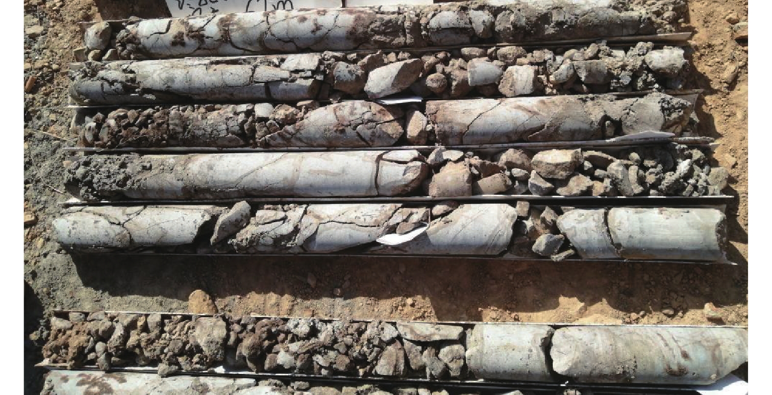
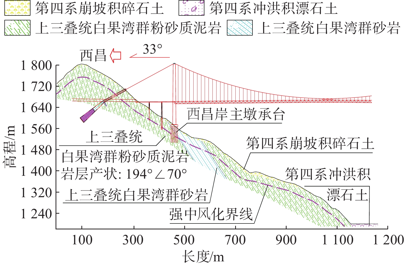
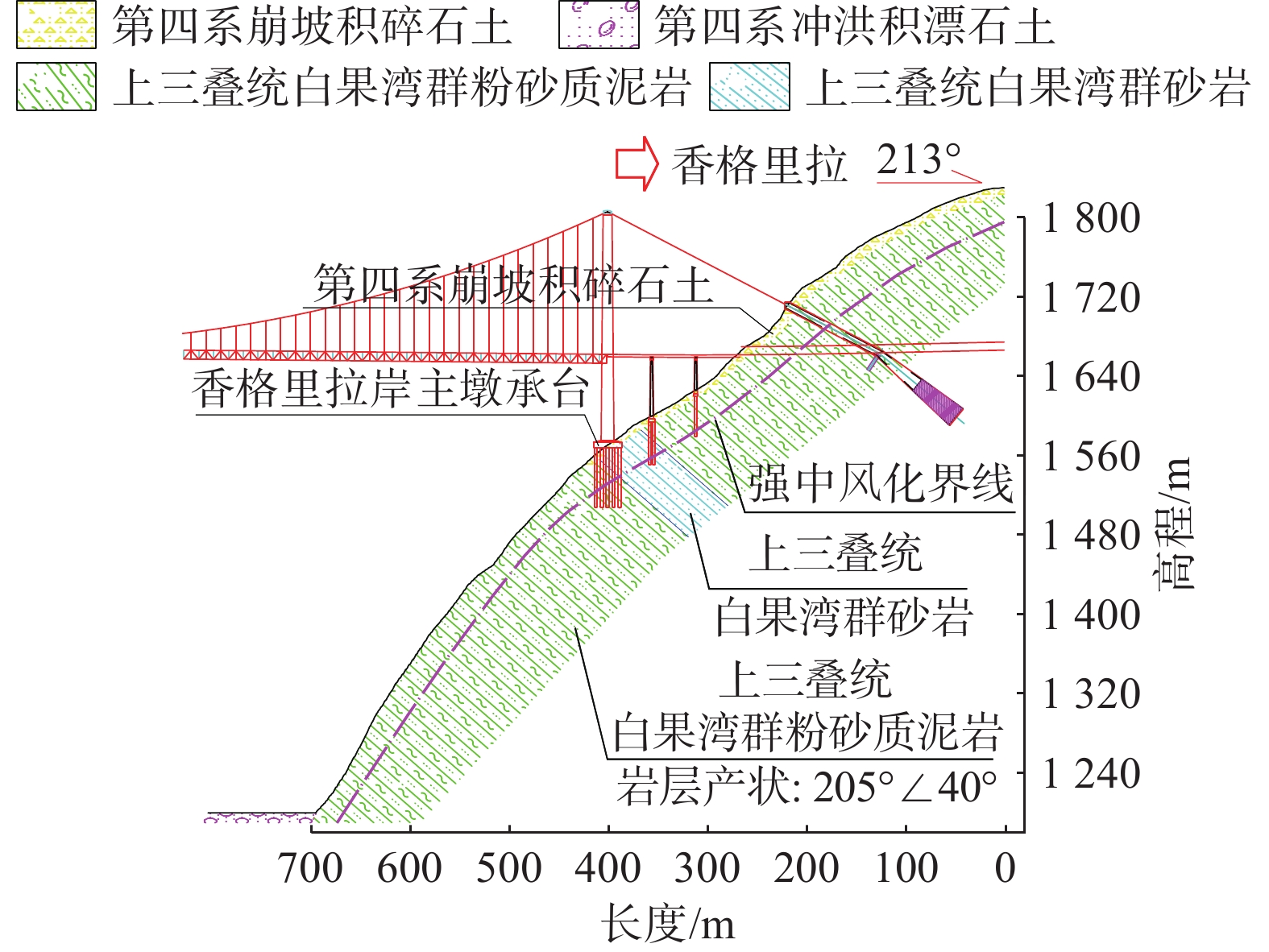
图 2 风化卸荷变形区岩芯特征
Figure 2. Characteristics of rock core in weathering and unloading deformation zone
![]()
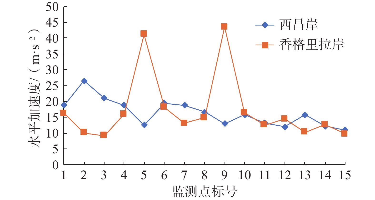
图 8 监测点峰值地震水平加速度折线图
Figure 8. Peak seismic horizontal acceleration at monitoring points
![]()
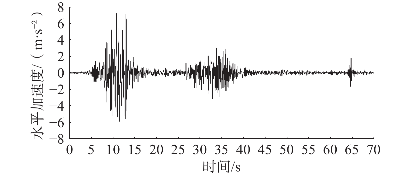
图 9 西昌岸监测点5地震水平加速度时程曲线
Figure 9. Seismic horizontal acceleration time history curve of monitoring point 5 on Xichang bank
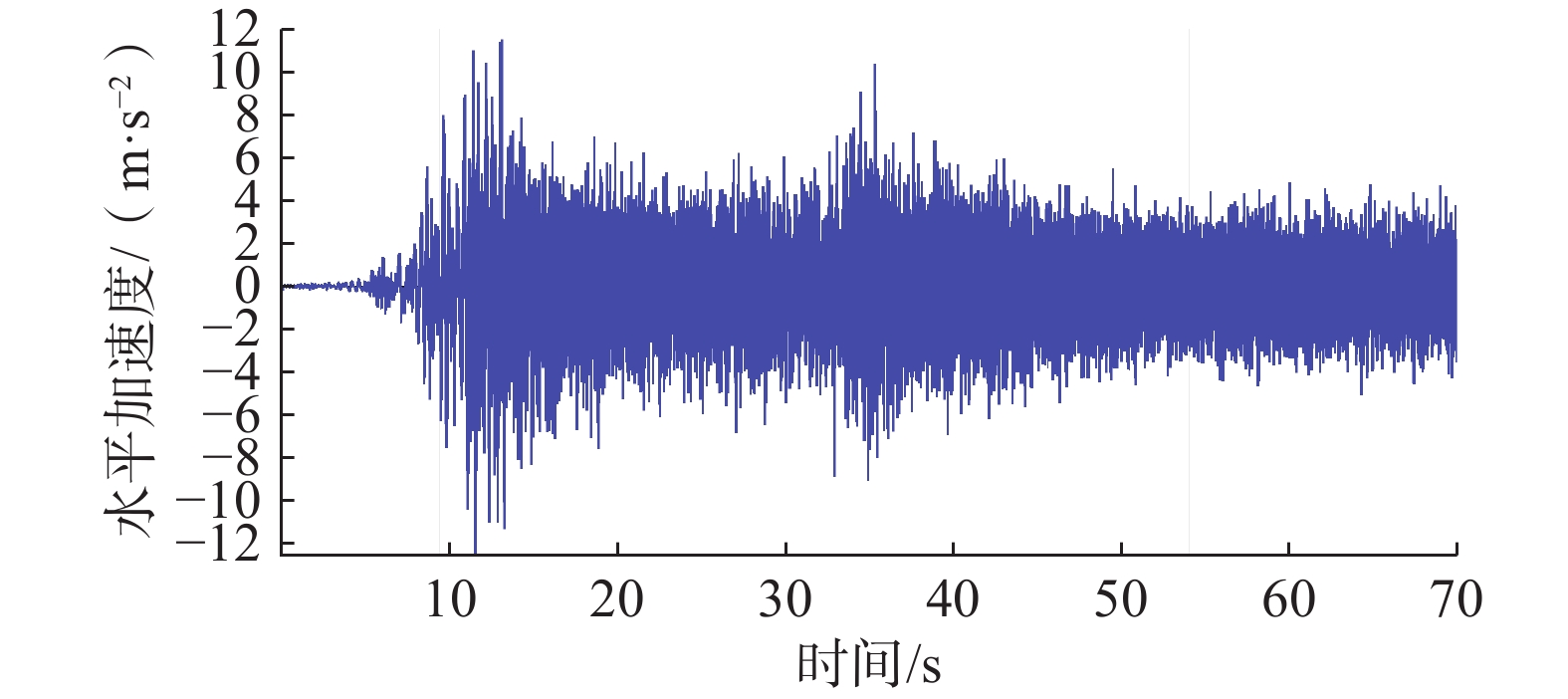
![]()
图 10 香格里拉岸监测点5地震水平加速度时程曲线
Figure 10. Seismic horizontal acceleration time history curve of monitoring point 5 on Xianggelila bank
![]()
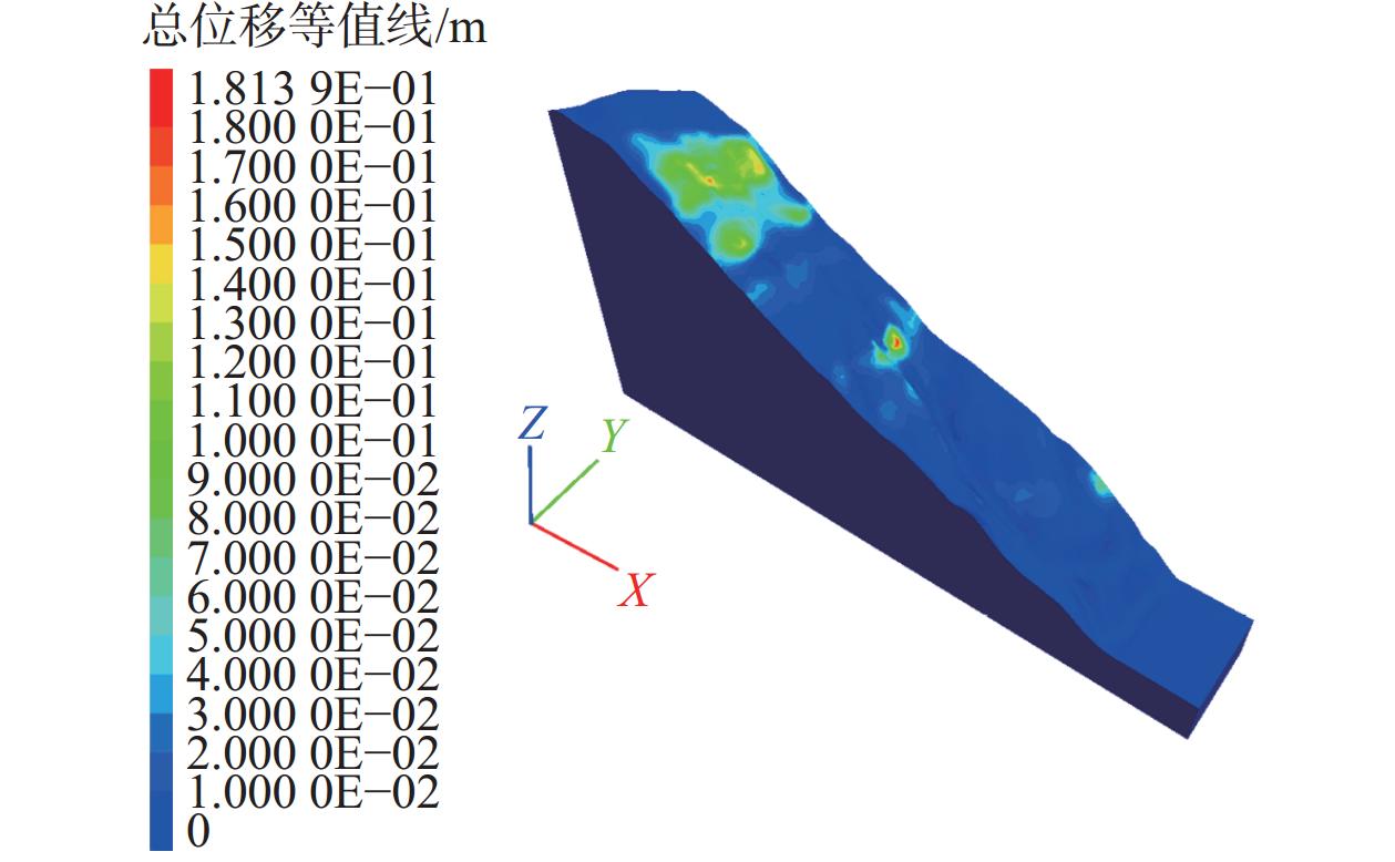
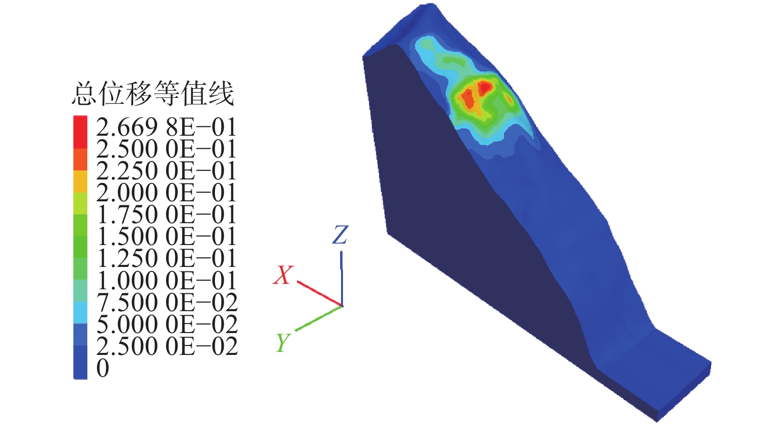
图 13 西昌岸E1地震工况总位移图
Figure 13. Total displacement diagram of Xichang bank under E1 earthquake condition
![]()
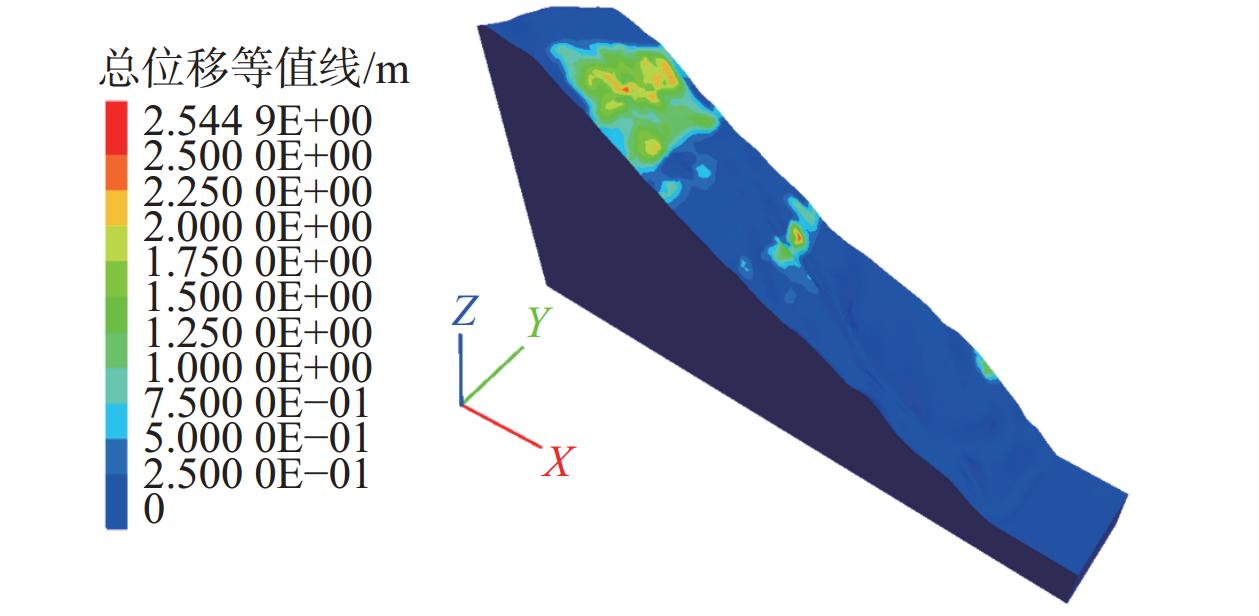
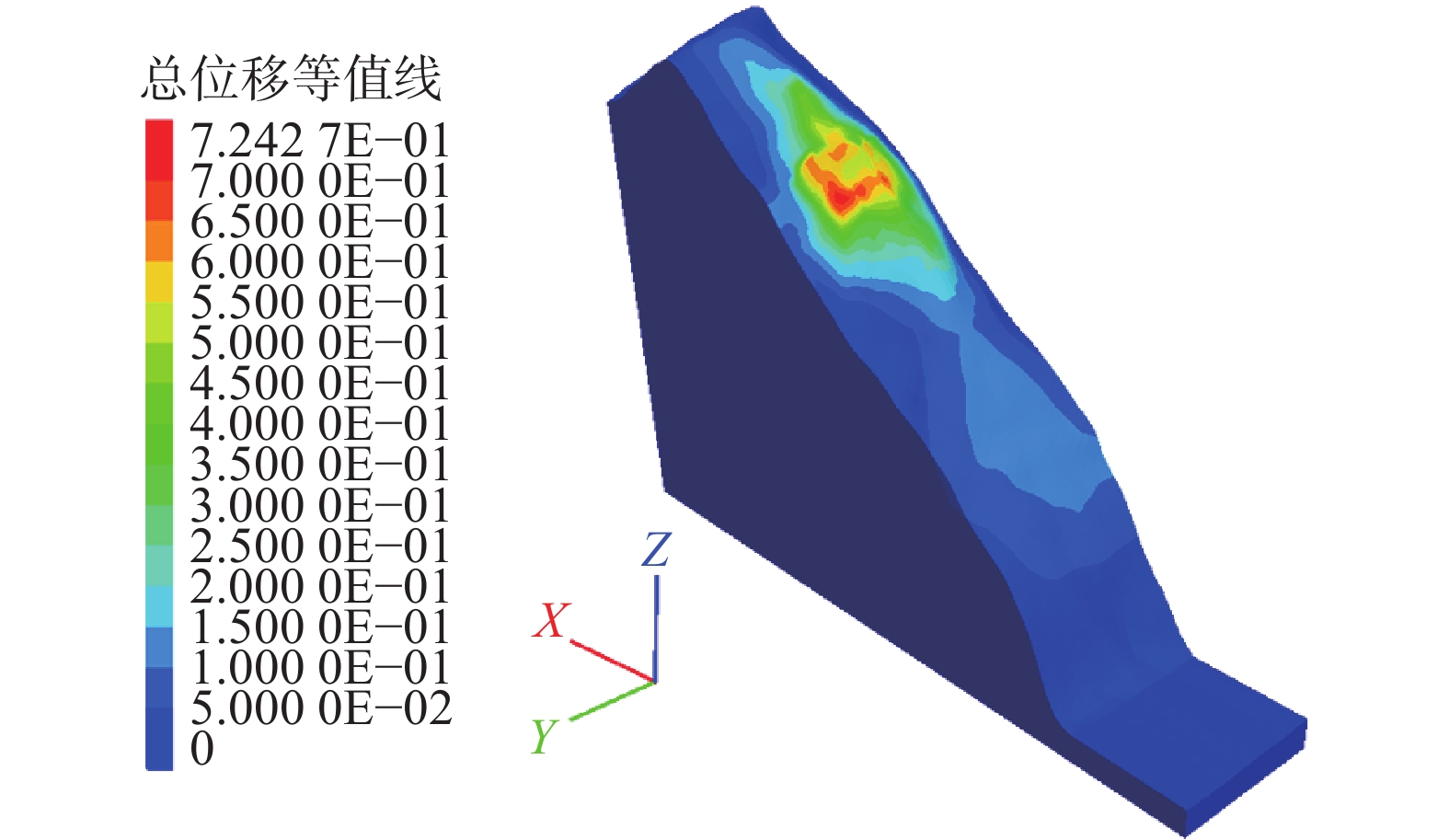
图 14 西昌岸E2地震工况总位移图
Figure 14. Total displacement diagram of Xichang bank under E2 earthquake condition
![]()
图 15 香格里拉岸E1地震工况总位移图
Figure 15. Total displacement diagram of Xianggelila bank under E1 earthquake condition
![]()
图 16 香格里拉岸E2地震工况总位移图
Figure 16. Total displacement diagram of Xianggelila bank under E2 earthquake condition
![]()
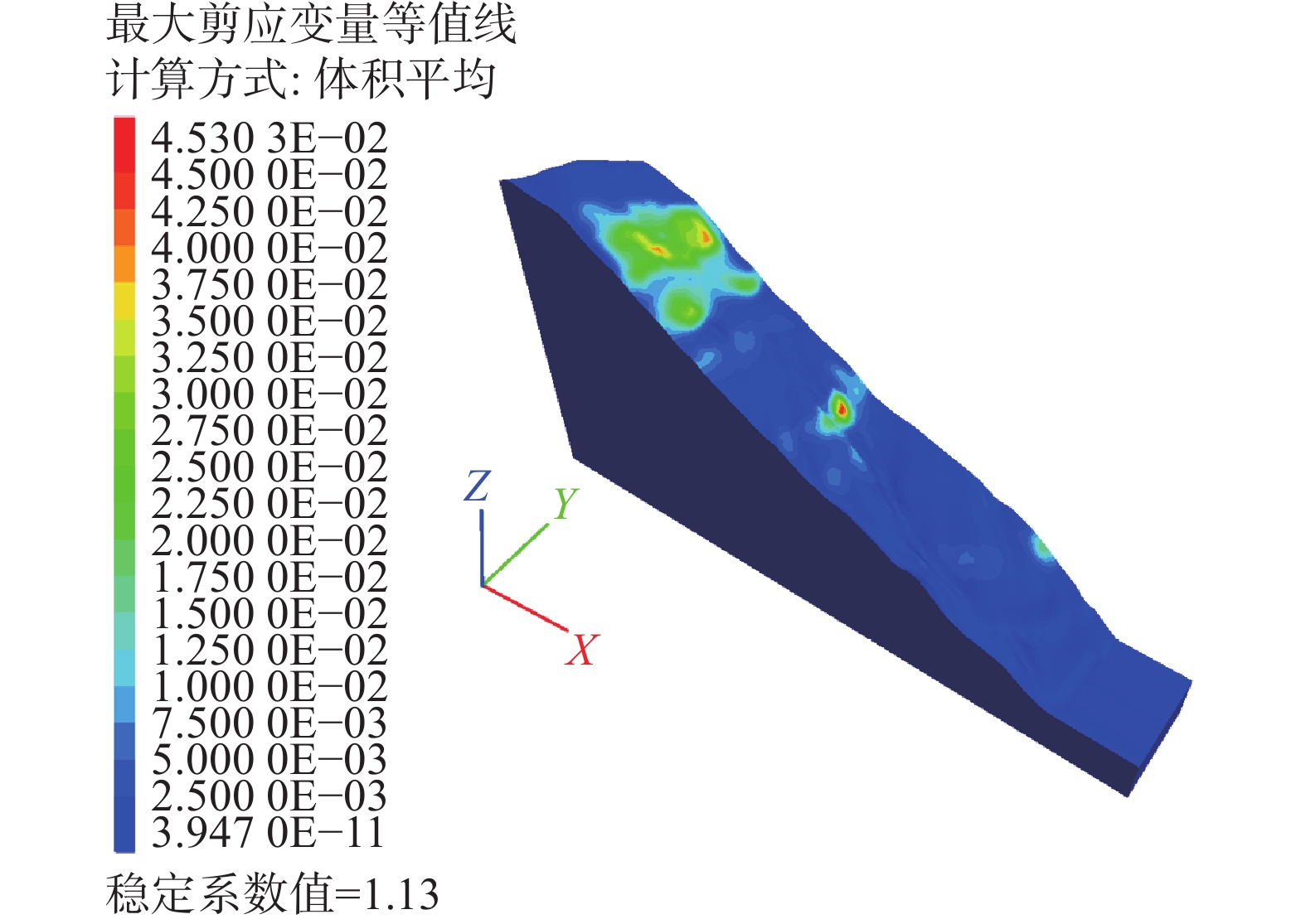
图 17 西昌岸E1地震工况折减至极限状态的剪应变增量
Figure 17. Shear strain increment of Xichang bank under E1 earthquake condition
![]()
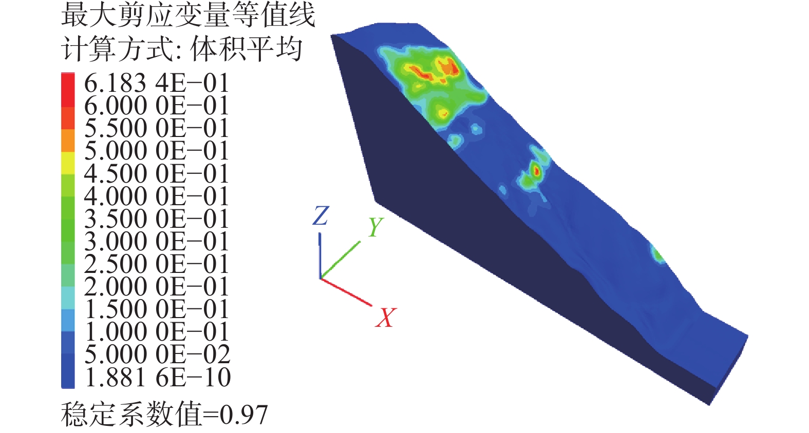
图 18 西昌岸E2地震工况折减至极限状态的剪应变增量
Figure 18. Shear strain increment of Xichang bank under E2 earthquake condition
![]()
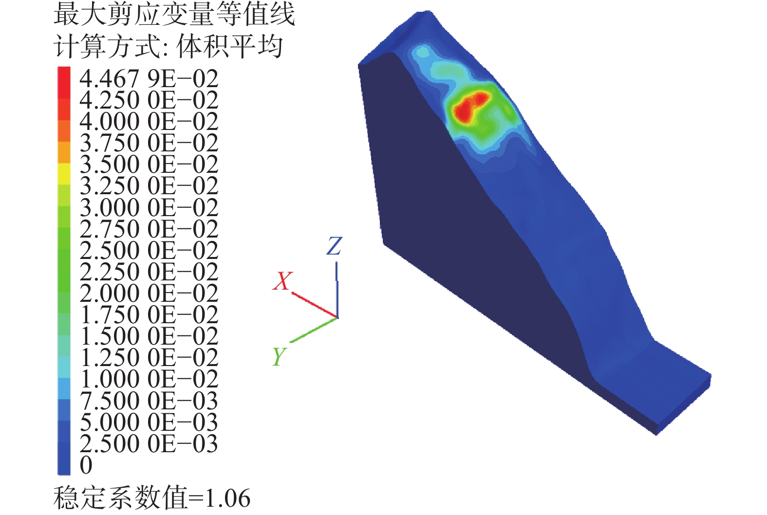
图 19 香格里拉岸E1工况折减至极限状态剪应变增量
Figure 19. Shear strain increment and stability coefficient of Xianggelila bank under E1 earthquake condition
![]()
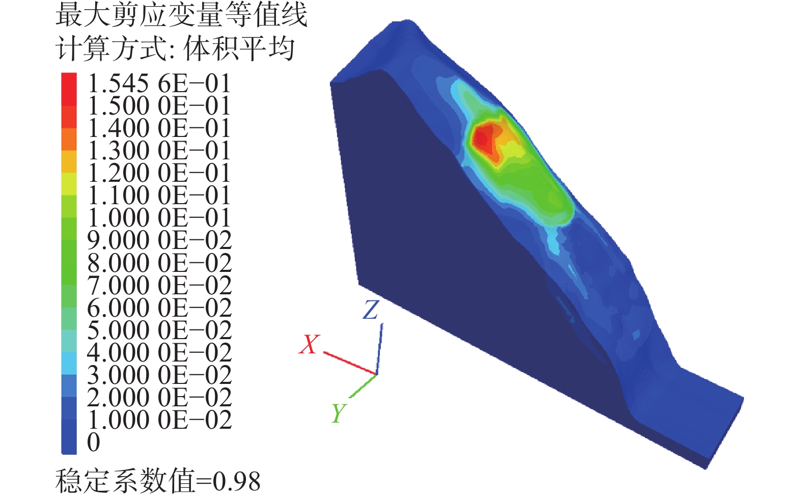
图 20 香格里拉岸E2工况折减至极限状态的剪应变增量
Figure 20. Shear strain increment and stability coefficient of Xianggelila bank under E2 earthquake condition
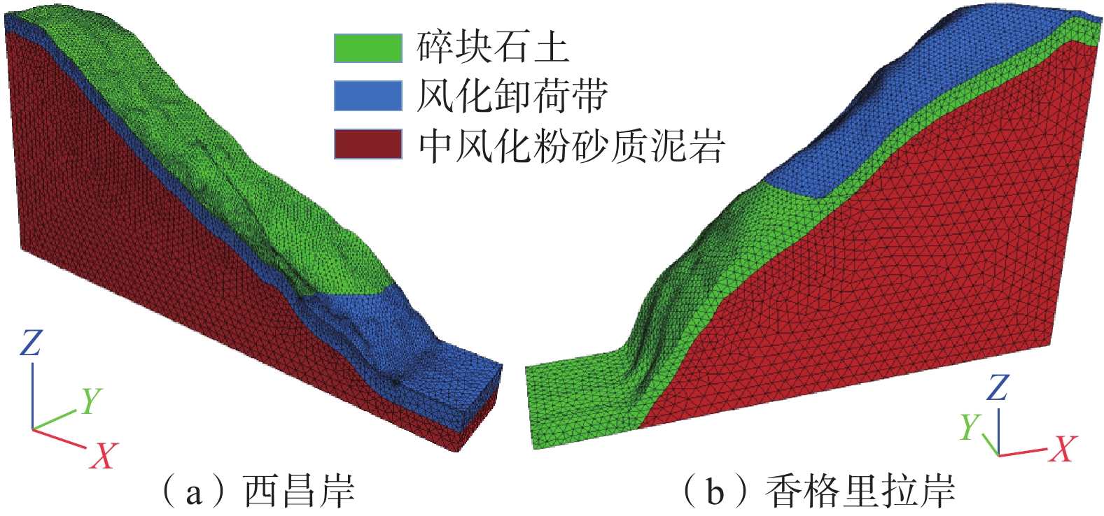
表 1 岩土体的物理力学参数
Table 1 Physical and mechanical parameters of rock and soil
区域 弹模
/MPa泊松比 黏聚力/kPa 内摩擦角/(°) 容重/(kN·m−3) 天然 暴雨 天然 暴雨 天然 暴雨 碎块石土 60 0.32 15 13 27.0 24.0 20.0 21.0 卸荷带 300 0.28 120 108 42.2 38.0 24.0 25.0 中风化岩 800 0.27 507 456 49.9 44.9 26.5 27.0  下载: 导出CSV
表 2 监测点峰值地震水平加速度和放大系数(ξ)
Table 2 Peak seismic horizontal acceleration and amplification factor of monitoring points
编号 西昌岸 香格里拉岸 峰值地震水平加速度 ξ 峰值地震水平加速度 ξ 1 18.779 2.61 16.249 2.26 2 26.536 3.69 19.068 1.40 3 21.003 2.92 14.210 1.28 4 18.763 2.61 15.963 2.22 5 12.581 1.75 43.467 6.04 6 19.471 2.71 18.124 2.52 7 18.848 2.61 13.097 1.82 8 16.650 2.32 14.919 2.07 9 12.434 1.80 41.169 5.72 10 15.802 2.20 16.488 2.29 11 13.193 1.83 12.499 1.74 12 11.940 1.66 14.474 2.01 13 15.797 2.20 10.257 1.43 14 12.253 1.70 12.484 1.76 15 10.975 1.53 9.688 1.35
下载: 导出CSV
表 3 考虑修正放大系数下不同工况边坡FS及稳定状态
Table 3 FS and stable state of various conditions with considering the correction amplification factor
岸坡 天然工况 暴雨工况 E1地震 E2地震 FS 状态 FS 状态 FS 状态 FS 状态 西昌 1.35 稳定 1.26 稳定 1.13 稳定 0.97 失稳 香格里拉 1.26 稳定 1.12 稳定 1.06 基本稳定 0.98 失稳
下载: 导出CSV
表 4 未考虑修正放大系数下地震工况的FS及稳定状态
Table 4 FS and stable state of seismic conditions without considering the correction amplification factor
岸坡 E1地震 E2地震 FS 状态 FS 状态 西昌 1.15 稳定 0.99 失稳 香格里拉 1.11 稳定 1.04 欠稳定
下载: 导出CSV
-
[1] 彭建兵,崔鹏,庄建琦. 川藏铁路对工程地质提出的挑战[J]. 岩石力学与工程学报,2020,39(12):2377 − 2389. [PENG Jianbing,CUI Peng,ZHUANG Jianqi. Challenges to engineering geology of Sichuan—Tibet railway[J]. Chinese Journal of Rock Mechanics and Engineering,2020,39(12):2377 − 2389. (in Chinese with English abstract)] PENG Jianbing, CUI Peng, ZHUANG Jianqi. Challenges to engineering geology of Sichuan—Tibet railway[J]. Chinese Journal of Rock Mechanics and Engineering, 2020, 39(12): 2377 − 2389. (in Chinese with English abstract)
[2] 袁进科,陈杰. 汶川地震公路边坡灾害分析及震后边坡灾害发育特点[J]. 公路,2020,65(5):26 − 33. [YUAN Jinke,CHEN Jie. Analysis of highway slope disaster in Wenchuan earthquake and its development characteristics after earthquake[J]. Highway,2020,65(5):26 − 33. (in Chinese with English abstract)] YUAN Jinke, CHEN Jie. Analysis of highway slope disaster in Wenchuan earthquake and its development characteristics after earthquake[J]. Highway, 2020, 65(5): 26 − 33. (in Chinese with English abstract)
[3] 张伯艳,王璨,李德玉,等. 地震作用下水利水电工程边坡稳定分析研究进展[J]. 中国水利水电科学研究院学报,2018,16(3):168 − 178. [ZHANG Boyan,WANG Can,LI Deyu,et al. The research progress on seismic stability analysis of slopes in water conservancy and hydropower projects[J]. Journal of China Institute of Water Resources and Hydropower Research,2018,16(3):168 − 178. (in Chinese with English abstract)] ZHANG Boyan, WANG Can, LI Deyu, et al. The research progress on seismic stability analysis of slopes in water conservancy and hydropower projects[J]. Journal of China Institute of Water Resources and Hydropower Research, 2018, 16(3): 168 − 178. (in Chinese with English abstract)
[4] 郭延辉,杨溢,高才坤,等. 云南鲁甸地震红石岩堰塞湖右岸特高边坡综合监测及变形特征分析[J]. 中国地质灾害与防治学报,2020,31(6):30 − 37. [GUO Yanhui,YANG Yi,GAO Caikun,et al. Comprehensive monitoring and deformation analysis of extra high slope on the right bank of Hongshiyan dammed lake in Ludian Earthquake[J]. The Chinese Journal of Geological Hazard and Control,2020,31(6):30 − 37. (in Chinese with English abstract)] GUO Yanhui, YANG Yi, GAO Caikun, et al. Comprehensive monitoring and deformation analysis of extra high slope on the right bank of Hongshiyan dammed lake in Ludian Earthquake[J]. The Chinese Journal of Geological Hazard and Control, 2020, 31(6): 30 − 37. (in Chinese with English abstract)
[5] 胡爱国,周伟. 地震与强降雨作用下堆积体滑坡变形破坏机理及防治方案分析[J]. 中国地质灾害与防治学报,2022,33(1):27 − 34. [HU Aiguo,ZHOU Wei. Deformation and failure mechanism and analysis on prevention measures of colluction landslide under earthquake and heavy rainfall[J]. The Chinese Journal of Geological Hazard and Control,2022,33(1):27 − 34. (in Chinese with English abstract)] HU Aiguo, ZHOU Wei. Deformation and failure mechanism and analysis on prevention measures of colluction landslide under earthquake and heavy rainfall[J]. The Chinese Journal of Geological Hazard and Control, 2022, 33(1): 27 − 34. (in Chinese with English abstract)
[6] 周洪福,冯治国,石胜伟,等. 川藏铁路某特大桥成都侧岸坡工程地质特征及稳定性评价[J]. 水文地质工程地质,2021,48(5):112 − 119. [ZHOU Hongfu,FENG Zhiguo,SHI Shengwei,et al. Slope engineering geology characteristics and stability evaluation of a grand bridge to Chengdu bank on the Sichuan—Tibet Railway[J]. Hydrogeology & Engineering Geology,2021,48(5):112 − 119. (in Chinese with English abstract)] ZHOU Hongfu, FENG Zhiguo, SHI Shengwei, et al. Slope engineering geology characteristics and stability evaluation of a grand bridge to Chengdu bank on the Sichuan—Tibet Railway[J]. Hydrogeology & Engineering Geology, 2021, 48(5): 112 − 119. (in Chinese with English abstract)
[7] 刘天翔,杜兆萌,程强,等. 红层软岩高边坡的时效变形特性[J]. 科学技术与工程,2020,20(27):11315 − 11322. [LIU Tianxiang,DU Zhaomeng,CHENG Qiang,et al. Time-dependent deformation characteristics of high slope in red layer soft rock[J]. Science Technology and Engineering,2020,20(27):11315 − 11322. (in Chinese with English abstract)] DOI: 10.3969/j.issn.1671-1815.2020.27.050 LIU Tianxiang, DU Zhaomeng, CHENG Qiang, et al. Time-dependent deformation characteristics of high slope in red layer soft rock[J]. Science Technology and Engineering, 2020, 20(27): 11315 − 11322. (in Chinese with English abstract) DOI: 10.3969/j.issn.1671-1815.2020.27.050
[8] 陈廷君,肖世国,程强,等. 泸定大渡河桥康定岸重力锚边坡长期变形与稳定性分析[J]. 工程地质学报,2019,27(3):632 − 639. [CHEN Tingjun,XIAO Shiguo,CHENG Qiang,et al. Long-term deformation and stability analysis of gravity anchorage slope on Kangding bank of Dadu River bridge in Luding[J]. Journal of Engineering Geology,2019,27(3):632 − 639. (in Chinese with English abstract)] CHEN Tingjun, XIAO Shiguo, CHENG Qiang, et al. Long-term deformation and stability analysis of gravity anchorage slope on Kangding bank of Dadu River bridge in Luding[J]. Journal of Engineering Geology, 2019, 27(3): 632 − 639. (in Chinese with English abstract)
[9] 郭鸿俊,姜清辉,孙金山. 大岗山水电站右岸高边坡加固方案优化研究[J]. 人民长江,2012,43(15):16 − 19. [GUO Hongjun,JIANG Qinghui,SUN Jinshan. Optimization for reinforcement plan of right-bank high slope of Dagangshan Hydropower Station[J]. Yangtze River,2012,43(15):16 − 19. (in Chinese with English abstract)] DOI: 10.3969/j.issn.1001-4179.2012.15.005 GUO Hongjun, JIANG Qinghui, SUN Jinshan. Optimization for reinforcement plan of right-bank high slope of Dagangshan Hydropower Station[J]. Yangtze River, 2012, 43(15): 16 − 19. (in Chinese with English abstract) DOI: 10.3969/j.issn.1001-4179.2012.15.005
[10] 张泽鹏,朱凤贤,黄放军,等. 复杂地质条件下高边坡加固设计与综合治理研究——以梅河高速公路某高边坡治理为例[J]. 中山大学学报(自然科学版),2006,45(4):44 − 48. [ZHANG Zepeng,ZHU Fengxian,HUANG Fangjun,et al. Research on reinforcement design and comprehensive improvement for high slopes under complicated geological conditions[J]. Acta Scientiarum Naturalium Universitatis Sunyatseni,2006,45(4):44 − 48. (in Chinese with English abstract)] ZHANG Zepeng, ZHU Fengxian, HUANG Fangjun, et al. Research on reinforcement design and comprehensive improvement for high slopes under complicated geological conditions[J]. Acta Scientiarum Naturalium Universitatis Sunyatseni, 2006, 45(4): 44 − 48. (in Chinese with English abstract)
[11] 张江伟,李小军. 地震作用下边坡稳定性分析方法[J]. 地震学报,2015,37(1):180 − 191. [ZHANG Jiangwei,LI Xiaojun. A review on the stability analysis methods of slope under seismic loading[J]. Acta Seismologica Sinica,2015,37(1):180 − 191. (in Chinese with English abstract)] DOI: 10.11939/j.issn:0253-3782.2015.01.016 ZHANG Jiangwei, LI Xiaojun. A review on the stability analysis methods of slope under seismic loading[J]. Acta Seismologica Sinica, 2015, 37(1): 180 − 191. (in Chinese with English abstract) DOI: 10.11939/j.issn:0253-3782.2015.01.016
[12] 崔玉龙,刘爱娟. 区域边坡地震危险性评价理论研究进展[J]. 地震工程学报,2022,44(3):518 − 526. [CUI Yulong,LIU Aijuan. Advances in the theory of seismic hazard assessment of regional slopes[J]. China Earthquake Engineering Journal,2022,44(3):518 − 526. (in Chinese with English abstract)] CUI Yulong, LIU Aijuan. Advances in the theory of seismic hazard assessment of regional slopes[J]. China Earthquake Engineering Journal, 2022, 44(3): 518 − 526. (in Chinese with English abstract)
[13] 李亮,褚雪松,庞峰,等. 地震边坡稳定性分析的拟静力方法适用性探讨[J]. 世界地震工程,2012,28(2):57 − 63. [LI Liang,CHU Xuesong,PANG Feng,et al. Discussion on suitability of pseudo-static method in seismic slope stability analysis[J]. World Earthquake Engineering,2012,28(2):57 − 63. (in Chinese with English abstract)] DOI: 10.3969/j.issn.1007-6069.2012.02.010 LI Liang, CHU Xuesong, PANG Feng, et al. Discussion on suitability of pseudo-static method in seismic slope stability analysis[J]. World Earthquake Engineering, 2012, 28(2): 57 − 63. (in Chinese with English abstract) DOI: 10.3969/j.issn.1007-6069.2012.02.010
[14] 郑颖人,叶海林,肖强,等. 基于全动力分析法的地震边坡与隧道稳定性分析[J]. 防灾减灾工程学报,2010,30(增刊1):279 − 285. [ZHENG Yingren,YE Hailin,XIAO Qiang,et al. Stability analysis of earthquake slope and tunnel based on full dynamic analysis method[J]. Journal of Disaster Prevention and Mitigation Engineering,2010,30(Sup 1):279 − 285. (in Chinese with English abstract)] ZHENG Yingren, YE Hailin, XIAO Qiang, et al. Stability analysis of earthquake slope and tunnel based on full dynamic analysis method[J]. Journal of Disaster Prevention and Mitigation Engineering, 2010, 30(Sup 1): 279 − 285. (in Chinese with English abstract)
[15] 张迎宾,柳静,唐云波,等. 考虑边坡地形效应的地震动力响应分析[J]. 地震工程学报,2021,43(1):142 − 153. [ZHANG Yingbin,LIU Jing,TANG Yunbo,et al. Dynamic response analysis of seismic slopes considering topographic effect[J]. China Earthquake Engineering Journal,2021,43(1):142 − 153. (in Chinese with English abstract)] ZHANG Yingbin, LIU Jing, TANG Yunbo, et al. Dynamic response analysis of seismic slopes considering topographic effect[J]. China Earthquake Engineering Journal, 2021, 43(1): 142 − 153. (in Chinese with English abstract)
[16] 王来贵,向丽,赵娜,等. 地震作用下顺倾多弱层岩质边坡动力响应[J]. 中国地质灾害与防治学报,2021,32(6):18 − 25. [WANG Laigui,XIANG Li,ZHAO Na,et al. Dynamic response of down-dip multi-weak-layer rock slope under earthquake[J]. The Chinese Journal of Geological Hazard and Control,2021,32(6):18 − 25. (in Chinese with English abstract)] WANG Laigui, XIANG Li, ZHAO Na, et al. Dynamic response of down-dip multi-weak-layer rock slope under earthquake[J]. The Chinese Journal of Geological Hazard and Control, 2021, 32(6): 18 − 25. (in Chinese with English abstract)
[17] 林峻岑,严松宏,孙纬宇,等. 三向地震作用下错距岩质边坡共振特性研究[J]. 水文地质工程地质,2023,50(2):95 − 102. [LIN Juncen,YAN Songhong,SUN Weiyu,et al. A study of the resonance characteristics of a staggered rock slope under the tri-dimension earthquake wave[J]. Hydrogeology & Engineering Geology,2023,50(2):95 − 102. (in Chinese with English abstract)] LIN Juncen, YAN Songhong, SUN Weiyu, et al. A study of the resonance characteristics of a staggered rock slope under the tri-dimension earthquake wave[J]. Hydrogeology & Engineering Geology, 2023, 50(2): 95 − 102. (in Chinese with English abstract)
[18] 李郑梁,李建春,刘波,等. 浅切割的高山峡谷复杂地形的地震动放大效应研究[J]. 工程地质学报,2021,29(1):137 − 150. [LI Zhengliang,LI Jianchun,LIU Bo,et al. Seismic motion amplification effect of shallow-cutting hill-canyon composite topography[J]. Journal of Engineering Geology,2021,29(1):137 − 150. (in Chinese with English abstract)] LI Zhengliang, LI Jianchun, LIU Bo, et al. Seismic motion amplification effect of shallow-cutting hill-canyon composite topography[J]. Journal of Engineering Geology, 2021, 29(1): 137 − 150. (in Chinese with English abstract)
[19] 孙强强,薄景山,孙有为,等. 隧道结构地震反应分析研究现状[J]. 世界地震工程,2016,32(2):159 − 169. [SUN Qiangqiang,BO Jingshan,SUN Youwei,et al. A state-of-the-art review of seismic response analysis of tunnels[J]. World Earthquake Engineering,2016,32(2):159 − 169. (in Chinese with English abstract)] SUN Qiangqiang, BO Jingshan, SUN Youwei, et al. A state-of-the-art review of seismic response analysis of tunnels[J]. World Earthquake Engineering, 2016, 32(2): 159 − 169. (in Chinese with English abstract)
[20] 邓鹏. 单体边坡地形的地震动力响应及其放大效应的数值分析[J]. 地震学报,2020,42(3):349 − 361. [DENG Peng. Numerical parametric study of seismic dynamic response and amplification effects of slope topography[J]. Acta Seismologica Sinica,2020,42(3):349 − 361. (in Chinese with English abstract)] DOI: 10.11939/jass.20190133 DENG Peng. Numerical parametric study of seismic dynamic response and amplification effects of slope topography[J]. Acta Seismologica Sinica, 2020, 42(3): 349 − 361. (in Chinese with English abstract) DOI: 10.11939/jass.20190133
[21] 门妮,孙有为,薄景山,等. 地震作用下边坡动力响应及影响因素研究[J]. 世界地震工程,2017,33(3):110 − 120. [MEN Ni,SUN Youwei,BO Jingshan,et al. Study on dynamic response and influence factors of slope under earthquake[J]. World Earthquake Engineering,2017,33(3):110 − 120. (in Chinese with English abstract)] MEN Ni, SUN Youwei, BO Jingshan, et al. Study on dynamic response and influence factors of slope under earthquake[J]. World Earthquake Engineering, 2017, 33(3): 110 − 120. (in Chinese with English abstract)
[22] 张江伟,周爱红,迟明杰,等. 边坡地震响应数值模拟中最优边界范围研究[J]. 防灾减灾工程学报,2022,42(1):34 − 41. [ZHANG Jiangwei,ZHOU Aihong,CHI Mingjie,et al. Research on boundary range in seismic response simulation of slope[J]. Journal of Disaster Prevention and Mitigation Engineering,2022,42(1):34 − 41. (in Chinese with English abstract)] ZHANG Jiangwei, ZHOU Aihong, CHI Mingjie, et al. Research on boundary range in seismic response simulation of slope[J]. Journal of Disaster Prevention and Mitigation Engineering, 2022, 42(1): 34 − 41. (in Chinese with English abstract)
[23] 郑颖人,叶海林,黄润秋,等. 边坡地震稳定性分析探讨[J]. 地震工程与工程振动,2010,30(2):173 − 180. [ZHENG Yingren,YE Hailin,HUANG Runqiu,et al. Study on the seismic stability analysis of a slope[J]. Journal of Earthquake Engineering and Engineering Vibration,2010,30(2):173 − 180. (in Chinese with English abstract)] ZHENG Yingren, YE Hailin, HUANG Runqiu, et al. Study on the seismic stability analysis of a slope[J]. Journal of Earthquake Engineering and Engineering Vibration, 2010, 30(2): 173 − 180. (in Chinese with English abstract)


计量
- 文章访问数: 118
- HTML全文浏览量: 32
- PDF下载量: 37
 邮件订阅
邮件订阅 RSS
RSS