

A case study on the susceptibility assessment of debris flows disasters based on prototype network in Nujiang Prefecture, Yunnan Province
-
摘要: 针对基于泥石流因子评价方法中选取因子不一及训练样本少的问题,提出了一种基于原型网络的沟谷泥石流灾害易发性评价方法。首先,通过元学习方式组织训练数据,计算每一类沟谷的原型中心。其次,计算未知样本与每一类原型中心的距离,得到其从属类别的概率。最后,根据类别概率计算沟谷的泥石流易发性指数,得到泥石流易发性评价等级。运用模型对怒江州的沟谷进行评价,并与历史灾害数据进行比对,分类正确率达到67.39%,历史事件中泥石流灾害严重程度与模型的评价等级吻合度较好。相比传统实地勘测和因子评价等方法,文章方法能够通过遥感影像进行泥石流灾害区域的快速识别与评价,为泥石流灾害的预警预测研究带来新的思路。Abstract: In response to the issues of inconsistent factor selection and limited training samples in debris flow factor-based evaluation methods, this study proposed a prototypical network-based approach for assessing the susceptibility of valley debris flow disasters. The method involves organizing the training data through meta-learning and calculating the prototype center for each valley type, serving as a representative of that category. Subsequently, the distance between the features of unknown samples and the prototype center of each class is computed to determine the probability of their classification. Based on the category probabilities, the debris flow susceptibility index of the valley is calculated to obtain the evaluation grade for debris flow susceptibility. The model was applied to evaluate the valleys in Nujiang Prefecture, and its results were compared with historical disaster data, yielding a classification accuracy rate of 67.39%. The evaluation levels provided by the model align well with the severity of debris flow disasters in historical events. Compared to traditional methods such as field surveys and factor evaluation, the method proposed in this paper allows for the rapid identification and evaluation of debris flow disaster areas using remote sensing imagery, presenting new insights for research on early warning and prediction of debris flow disasters.
-
0. 引言
泥石流是一种自然地质灾害,发生时对当地居民的人身和财产安全造成重大的危害。我国泥石流研究防治工作始于20世纪60年代,早期的泥石流研究依靠实地考察,结合实地数据分析得出防治方法。唐邦兴等[1 − 2]通过对我国山地泥石流的考察研究,绘制了我国早期1∶600万泥石流灾害分布与危险区划图。陈宁生等[3 − 5]、崔鹏等[6 − 8]对四川、云南、新疆、西藏等特定地区泥石流的考察,提出了有效的泥石流判别方法和防治策略。随着遥感技术的发展,从数字高程模型(DEM)和遥感数据中获取与泥石流相关的地形地貌类因子和物源类因子弥补了实地考察的不便,通过提取沟谷的地貌因子、物源和降雨等因子,使用动力学模型FLO-2D、Debris2D、MatDEM等模拟特定沟谷的泥石流动力学过程,能够较准确的研究该沟谷或此类沟谷泥石流形成机理并提出预警和防治方法。
为了能够大面积地研究和评估,将研究区域通过汇水面积或其他阈值划分为小流域单元,统计各单元的泥石流相关因子,通过模型学习泥石流流域因子蕴含的特征来完成其他流域的分类预测。李益敏等[9]提取云南怒江州小流域单元的流域距断裂带距离、岩性、流域水系密度等11个因子,建立模型预测得到泥石流易发性分区,并绘制了怒江小流域易发性分布图。孙滨等[10]选取高程、坡度和坡向等9个影响因子,建立东川地区的小流域评价模型进行泥石流易发性评价。赵岩[11]详细构建了地貌、物源和激发三类泥石流因子的数据库,选取流域10 min降雨量、植被覆盖、6 h均降雨量等8个因子,使用线性回归的方式来对泥石流发生频率进行预测。统计学的方法能够在区域尺度上进行预测,但划分流域的方法不一,并且专家学者收集的影响因子和建模方法不同,导致预警评价结果不一,很难量化其评价预测的准确性。为了规避这些“主观”选择因子的过程,将卷积神经网络自动提取图像特征的方法用于地质灾害影像的研究成为了新热点。刘坤香等[12]提取怒江州泥石流沟谷的DEM图像,使用改进的残差网络学习图像特征,并用其他沟谷的分类预测。杨小兵等[13]基于深度学习方法对泥石流堆积扇的多光谱遥感影像进行训练和识别,以此找寻更多的泥石流隐患点。神经网络学习需要大量的样本数据,而区域尺度上的灾害数据属于小样本问题,小样本学习的提出用于解决样本量少的学习情况。茹颖[14]在遥感影像较少的数据集上,使用小样本学习对遥感图像分类得到了比传统卷积神经网络更好的效果。张萌月[15]在遥感影像识别目标较少的情况下,使用小样本学习方法相对传统的卷积神经网络有绝对优势。
本文以沟谷为评价单元,提取怒江州遥感影像建立泥石流沟谷数据集,使用基于原型网络(Prototypes Net)[16]的小样本学习方法对发生泥石流的沟谷影像特征进行学习,并将模型用于其余大量沟谷的泥石流易发性评价,借助ArcGIS软件将每条沟谷易发性结果和易发性分区进行可视化。
1. 研究区域与实验数据
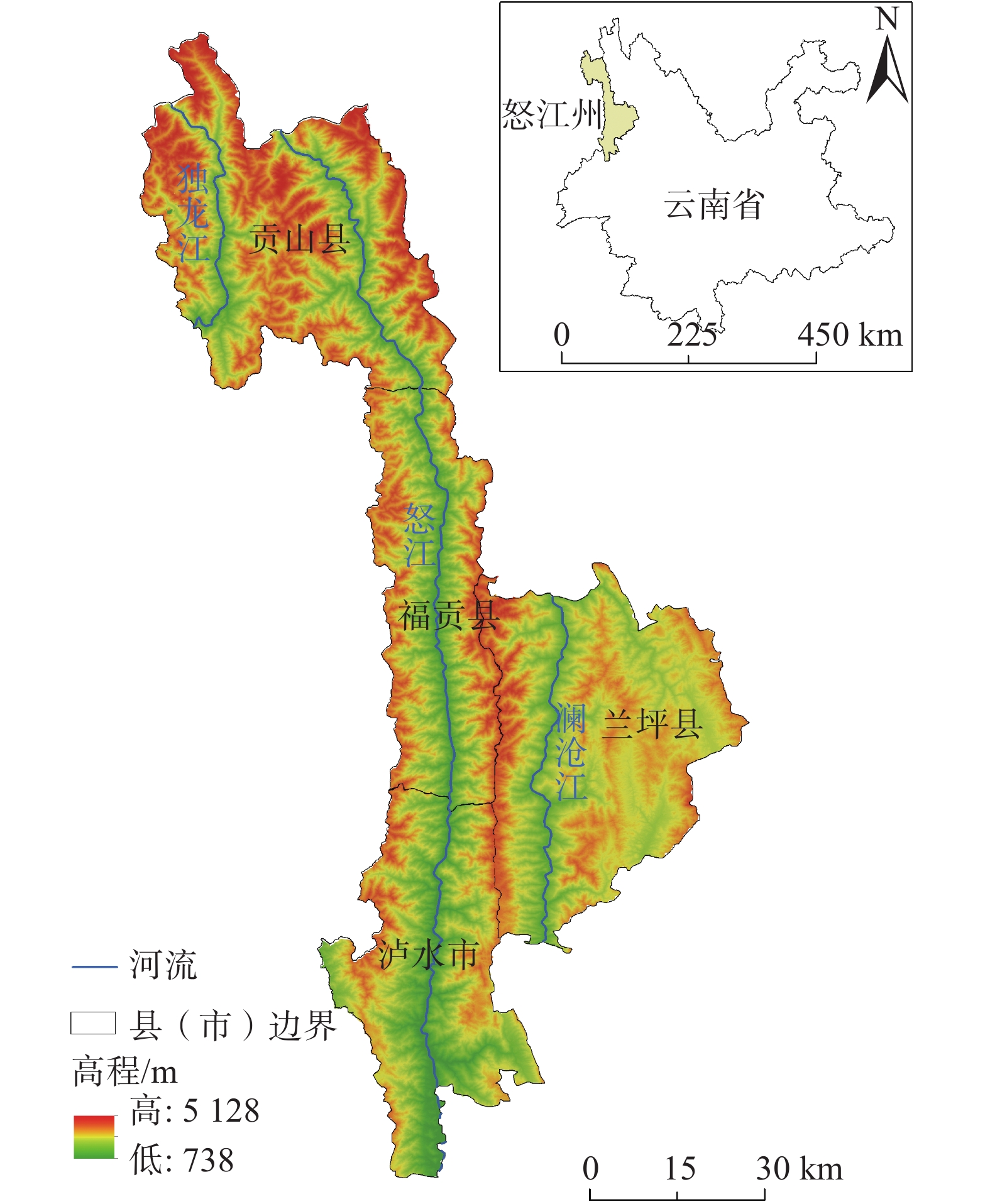
云南省怒江傈僳族自治州是全国发生泥石流最严重的州(市)之一,怒江州地处云南省西北部横断山脉纵向岭谷区,辖泸水市、福贡县、贡山县和兰坪县,总面积14584.95 km2。州内高黎贡山、怒山山脉、云岭山脉近南北向延伸,澜沧江(湄公河)、怒江(萨尔温江)、独龙江(伊洛瓦底江)等深切峡谷平行南下,河谷谷坡坡度一般35°~45°、部分达60°~70°。按云南省各年减灾年鉴及网络中的不完全统计,截至2022年,有相关文字记载的泥石流灾害中,福贡县至少发生69起泥石流灾害事件、贡山县至少67起、兰坪县至少24起、泸水市至少42起。1950—2021年,福贡县各年平均降水量达到3460 mm、贡山县1632 mm、兰坪县1550 mm、泸水市2596 mm[17]。较高的降水量、高山峡谷的特殊地形及其他因素导致了怒江州泥石流灾害的频发。怒江州的地理位置和地形分布情况如图1所示。
![]() 图 1 怒江州地理位置和地形分布情况Figure 1. Geographical location and topographical distribution of Nujiang Prefecture
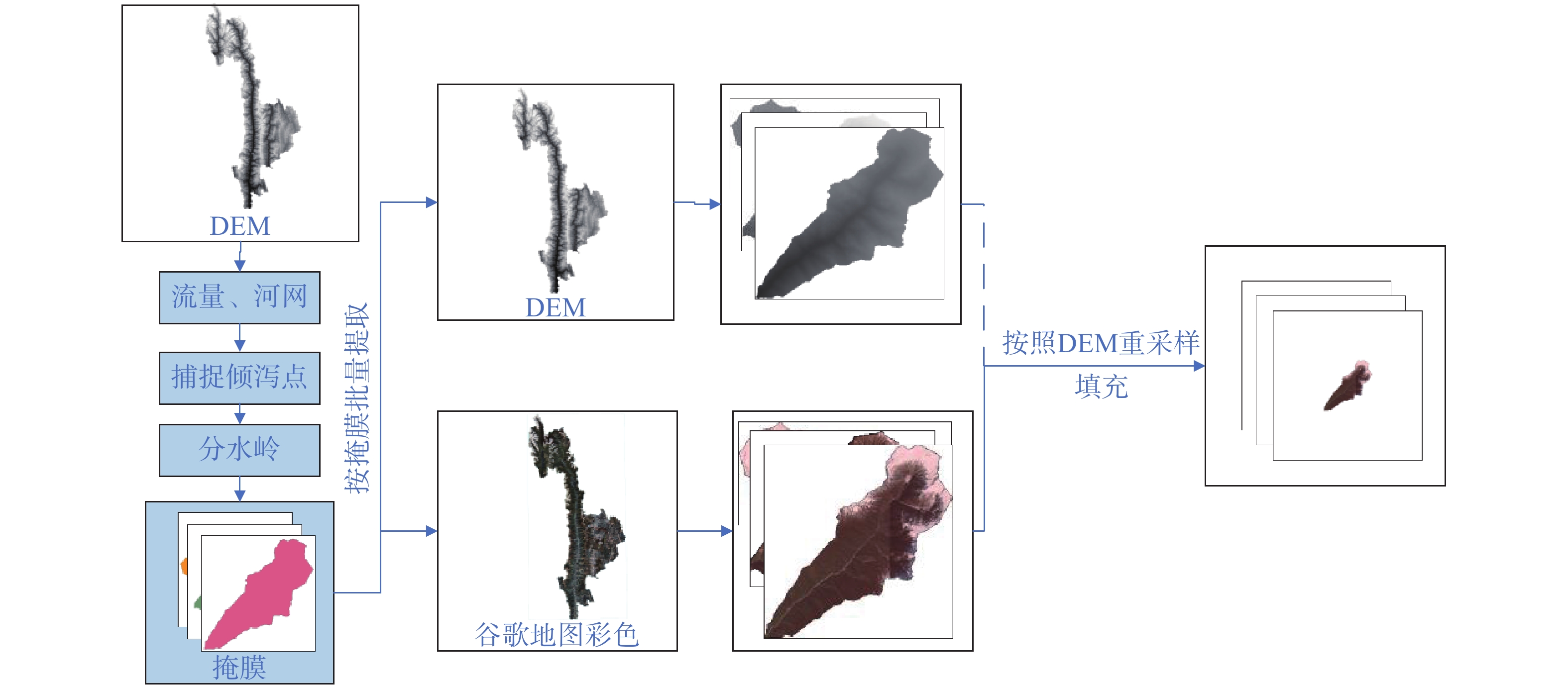
图 1 怒江州地理位置和地形分布情况Figure 1. Geographical location and topographical distribution of Nujiang Prefecture泥石流遥感数据集的建立主要使用谷歌地图(Google Earth)遥感影像,地图的高程数据由SRTM提供,空间分辨率30 m,遥感影像则由Landsat,QuickBird,Spot等遥感卫星提供。Google Earth拥有高精度的时间和空间分辨率,城市区域空间分辨率可达1m,农村地区可达2.5~5 m,边远山区可达15 m[18]。数据的提取和处理如图2所示,利用数字高程模型(DEM)获取每条沟谷的掩膜信息,按照掩膜批量提取Google Earth遥感图像,为了保留沟谷的大小特征,将提取的遥感图像按照DEM比例进行重采样,并按照最大DEM沟谷图像的尺寸进行填充处理。
![]() 图 2 Google Earth遥感数据的提取与处理Figure 2. Extraction and processing of Google Earth remote sensing data
图 2 Google Earth遥感数据的提取与处理Figure 2. Extraction and processing of Google Earth remote sensing data所使用的Google Earth遥感和DEM数据的信息如表1所示。
表 1 Google Earth遥感和DEM数据信息Table 1. Information on Google Earth remote sensing and DEM data数据信息 Google Earth DEM 数据来源 Google Earth软件 地理空间数据云
http://www.gscloud.cn/home数据类型 遥感图像 数字高程模型 空间分辨率 2~15 m
按照DEM采样为30 mASTER GDEM V2
垂直精度20m,水平精度30m通道数 3 1 时相 泥石流沟谷/与发生时间后最近时间分辨率影像图像
负样本及评测沟谷/最新遥感图像2015年1月6日发布的ASTER GDEM V2版本 泥石流遥感数据集包含正样本、负样本和待评价沟谷,正样本的确定是从《云南减灾年鉴》[19]、相关文献和网络报道中获得发生泥石流山谷和村庄的精确地点,依据坐标在Google Earth中与发生泥石流后最近的时间分辨率进行沟谷图像提取。负样本沟谷的确定依据为:在历史记录中不能检索到发生泥石流信息,影像中没有明显的冲积痕迹和堆积扇的形成且周围村庄密集。最终收集到泥石流沟谷50条作为正样本,未发生泥石流沟谷42条作为负样本,待评价沟谷样本600条。
2. 基于原型网络的沟谷泥石流灾害易发性评价方法
2.1 沟谷泥石流易发性评价流程
基于原型网络的沟谷泥石流易发性评价流程如图3所示,流程包括数据收集、沟谷提取、流域划分、数据集划分、数据集预分类、模型训练和预测、易发性评价和易发性分区图,详细流程如下。
![]() 图 3 基于原型网络的沟谷泥石流易发性评价流程Figure 3. Chartflow of susceptibility assessment of debris flow based on prototype networks
图 3 基于原型网络的沟谷泥石流易发性评价流程Figure 3. Chartflow of susceptibility assessment of debris flow based on prototype networks首先收集研究区域的DEM、Google Earth遥感影像和历史泥石流数据,按上一节中的数据提取流程,以沟谷流域为评价单元,提取得到Google Earth沟谷泥石流遥感影像数据集和沟谷流域分区。其次,考虑形态各异的沟谷潜在危险性存在特征差异,直接将沟谷分为正负样本两类训练,在忽略特征差异的同时网络模型也不稳定,按照影响泥石流的重要因子流域面积[20],将正负样本按流域面积大小各预分为小、中、大3类,0、1、2属于正样本,3、4、5属于负样本,如图3中数据集预分类标签所示。以元学习的形式组织正负样本数据并输入到原型网络模型中进行训练,将待评价沟谷样本输入到已训练的模型中,与6个沟谷分类进行相似度量,计算每个评价样本的泥石流易发性指数。最后将易发性指数分区,得到沟谷的泥石流易发性评价等级,在流域单元划分中可视化评价结果,得到易发性评价分区图。
从流程图中可以看出,与基于泥石流因子进行评价的流程相比,基于原型网络的沟谷泥石流易发性评价方法直接使用沟谷影像来学习泥石流沟谷的特征,减少了从小流域计算众多泥石流因子和泥石流因子筛选的繁琐过程,避免了选择不同因子带来的评价差异问题。原型网络在保证性能的前提下,能够快速高效的进行泥石流易发性的评价。
2.2 原型网络模型与泥石流易发性评价算法
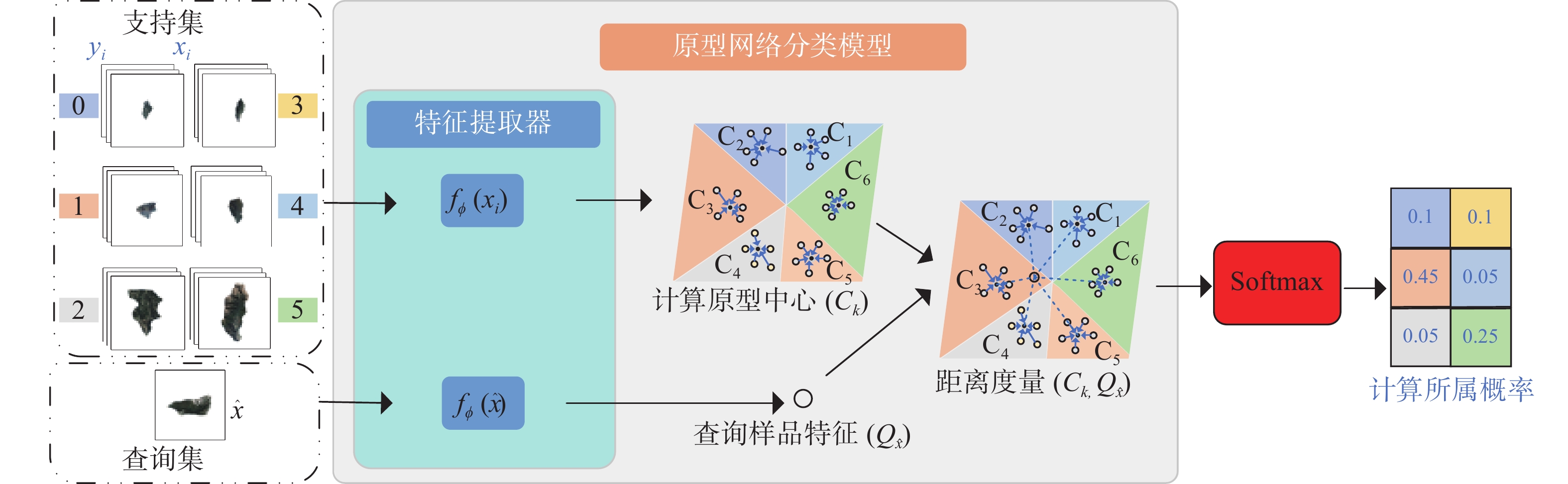
原型网络是小样本学习中经典的元学习和度量学习方法[21],网络模型如图4所示。原型网络以元学习的方式组织泥石流数据集进行训练,通过特征提取器(feature extractor)提取支持集(support set)每一类沟谷的特征,计算每类沟谷特征均值作为该类的原型中心(
2.2.1 基于元学习方法的原型中心计算
元学习分为元训练和元测试。元训练将有限的训练样本分为不同的子任务进行训练,在小样本学习中称为C-way K-shot问题。具体为:在N类训练样本中,每类有少量样本,学习时每个子任务选取C类(
在训练和测试泥石流数据时,原型网络将VGG[22]、GoogleNet[23]、ResNet[24]等不带分类器的卷积网络作为特征提取器,计算支持集中每一类沟谷的原型中心作为该类沟谷的代表,原型中心计算如式(1)所示:
(1) 式中:
2.2.2 样本类别概率计算
如果将普通的神经网络分类器训练在小样本学习的任务中,几乎都是过拟合。基于非参数度量的方法(例如:最近邻、k最近邻、K-means、距离度量等)不需要优化参数,可以在元学习框架下构建端到端的小样本分类器。原型网络使用余弦或欧氏距离的距离度量方式作为分类器,通过距离度量沟谷样本
(2) 式中:
在训练优化阶段,通过将式(3)中的目标函数
(3) 2.2.3 沟谷泥石流易发性等级评价
在进行沟谷的泥石流易发性评价时,通过计算沟谷的泥石流易发性指数来判定沟谷易发性等级。易发性指数通过所属类别概率来计算,文中原型网络使用欧氏距离来度量评价样本特征向量与类原型特征向量之间的相似程度,欧式距离越小,相似程度越大,使用式(2)计算所属类别的概率也就越大。
评价沟谷所属正样本中0、1、2类其中一类沟谷的概率越高,说明样本泥石流易发性越高。使用式(4)将所属概率转化为易发性指数。具体方法为:将正样本每类所属概率之和与负样本每类所属概率之和作差,差值大于等于0,表示评价样本与正样本相似程度更大,取正样本中的最大值作为易发性指数,值越大易发性越大。反之,差值小于0,取负样本中最大值的相反数为易发性指数,值越小易发性越小。将沟谷的易发性指数按大小进行分区,即可得到沟谷的易发性等级。
(4) 式中:
m、k——正样本、负样本的类别数,文中m=k=3。
3. 实验结果与分析
3.1 分类性能
本实验实现的硬件为CPU:Intel Xeon E5-2650 v3、内存:128GB、GPU:NVIDIA GeForce RTX 3090。软件为Ubuntu18.06、Pytorch1.9.0、python3.8、CUDA11.1。实验时设置训练输入为6-way 10-shot,即每轮选6类,每类选10张训练,测试时输入6-way 4shot 1query,即每轮测试选取6类,每类4张计算原型,1张作为测试。选取9个网络模型结构,包括VGG、GoogleNet、ShuffleNetV2[25]、MobileNetV2[26]、Conv4[27]、ResNet12[27]、ResNet18[24]、DenseNet[28]、Rir[29]作为原型网络的特征提取器,分类结果如表2所示。
表 2 多个特征提取器的分类性能Table 2. Classification performance of multiple feature extractors特征提取器 6分类/% 2分类/% VGG 55.43 59.78 GoogleNet 51.09 56.52 ShuffleNetV2 47.82 51.09 MobileNetV2 53.26 55.43 ResNet12 40.22 44.57 ResNet18 44.57 48.91 DenseNet 50.00 64.13 Rir 51.08 57.61 Conv4 58.70 67.39 表2中,2分类为只考虑正负样本的分类正确率,可以看出,提取沟谷特征时,Conv4在原型网络中的6分类和2分类正确率优于其他模型。将正负样本沟谷输入此模型进行测试,得到6分类结果的混淆矩阵和正负2分类的混淆矩阵如表3和表4所示。
表 3 6分类测试混淆矩阵Table 3. Confusion matrix of six-classification6分类混淆矩阵 预测值 0 1 2 3 4 5 真实值 0 9 2 0 2 1 0 1 0 10 1 0 2 6 2 0 2 12 0 0 3 3 2 2 0 9 0 0 4 0 8 0 0 5 2 5 0 0 4 0 1 9 表 4 正负2分类测试混淆矩阵Table 4. Confusion matrix for positive and negative binary-classification test2分类混淆矩阵 预测值 正样本 负样本 真实值 正样本 36 14 负样本 16 26 使用分类指标对分类结果进行衡量,计算6分类的卡帕系数(Kappa)和2分类的准确率(Accuracy)、精确率(Precision)、召回率(Recall)、F1 Score,得到表5指标表。
表 5 2分类和6分类指标表Table 5. Binary-classification and six-classification indicator tableAccuracy/% Precision/% Recall/% F1 Score Kappa 67.39 69.23 72.00 0.71 0.50 表2—4表明,Conv4表现出了良好的分类性能,作为模型的特征提取器能够带来更好的泥石流易发评价结果。
3.2 评价结果及分析
保持同样的模型参数,将600张怒江州待评价沟谷及正负样本输入网络,计算每一个沟谷样本属于6类沟谷的概率,按式(4)计算每个样本的易发性指数
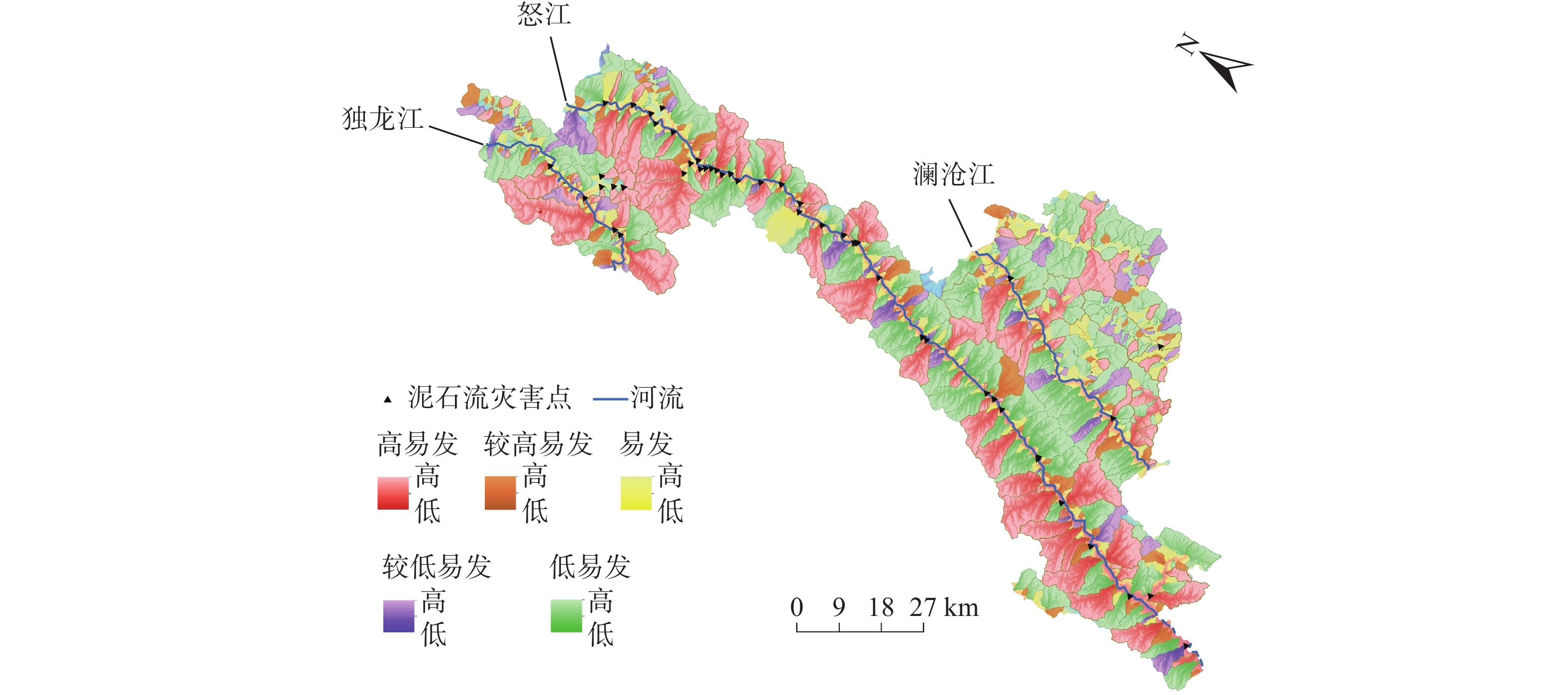
![]() 图 5 怒江州泥石流易发性分区图Figure 5. Susceptibility zoning map of debris flow in Nujiang Prefecture
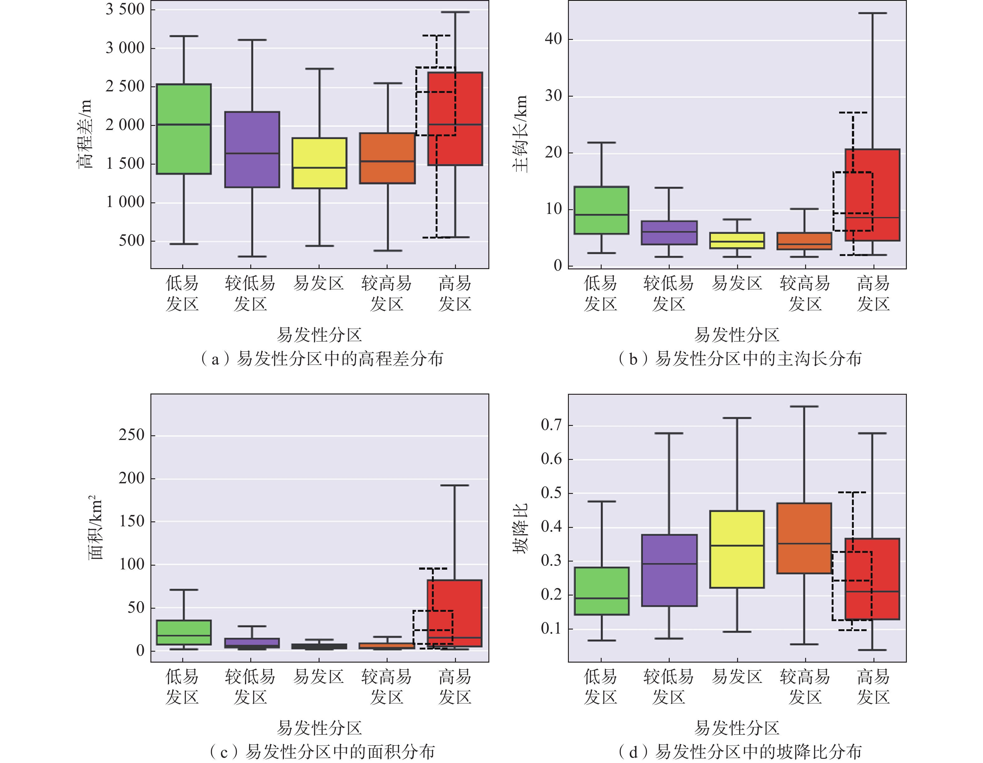
图 5 怒江州泥石流易发性分区图Figure 5. Susceptibility zoning map of debris flow in Nujiang Prefecture从图5中可以看出,预测为高易发的沟谷主要分布在贡山县、福贡县、泸水市中,兰坪县较少。易发性沟谷分区中,低易发区249条、较低易发区96条、易发区100条、较高易发区124条、高易发区123条。使用ArcGIS计算沟谷的高程差、主沟长度、沟谷投影面积和坡降比。计算时,高程差为ArcGIS中使用沟谷的最高海拔减去沟口海拔得出,主沟长度为ArcGIS中使用流量计算出最长的河流长度,沟谷面积为使用CGCS2000投影坐标得到的栅格面积,坡降比即沟床比降,为高程差与主沟长的比值,反映沟谷的整体陡度。按照易发性分区将高程差、主沟长度、沟谷面积和坡降比分布可视化,如图6所示,作为对比,正样本分布如图6中虚线空心箱线图所示。
![]() 图 6 怒江州泥石流易发性分区中沟谷高程差、沟长、面积、坡降比的分布情况Figure 6. Distribution of the valley elevation difference, valley length, area, and slope ratio in the debris flow susceptibility zone in Nujiang prefecture
图 6 怒江州泥石流易发性分区中沟谷高程差、沟长、面积、坡降比的分布情况Figure 6. Distribution of the valley elevation difference, valley length, area, and slope ratio in the debris flow susceptibility zone in Nujiang prefecture从分布情况中可知,在预测的沟谷中,低易发区、较低易发区、易发区、较高易发区在高程差、沟长、面积的分布上呈现下降趋势,坡降比呈上升趋势。易发区和较高易发区分布在高程差小、沟长短、面积小和坡降大的沟谷中。高易发区沟谷分布则较广,面积、高程差、沟长和坡降比从小到大都有高易发沟谷,这和正样本沟谷的分布有着相似的特点。
李益敏[9]使用泥石流因子评价方法,以5 km2的汇水面积为阈值,将怒江州划分为1 414个小流域单元,选取流域单元的距断裂带距离、岩性、Melton指数[30]、流域延伸率、流域高差率、河流弯曲系数、流域水系密度、平均植被覆盖度、年均降水量、距道路距离、距居民点距离共 11 个评价因子,采用确定性系数模型 CF 和多因子叠加权重确定法,对怒江州小流域单元进行泥石流易发性评价分区。与本文易发性分区对比,存在着相同点:预测为高易发及较高易发的沟谷(其文中为小流域)都集中在澜沧江以西,兰坪县较少,这与泥石流历史分布都较为符合。预测为高易发及较高易发沟谷(流域)数分别占全部沟谷(流域)的35.69%和34.72%,非常相近。
3.3 典型沟谷分析
在《云南省减灾年鉴》中检索到4条发生了人员伤亡或多次发生泥石流的沟谷,地理位置如图7中标签A、B、C、D处所示,编号A为贡山县普拉底乡东月谷,于2010年8月18日凌晨1时30分暴发特大山洪泥石流灾害,造成11 212人受灾,死亡96人,失踪53人,重伤9人,轻伤30人,转移安置灾民3 282人,直接经济损失1.4亿元。编号B为贡山县普拉底乡咪谷河,于2010年7月26日凌晨发生泥石流灾害,造成3人死亡、8人失踪、11人受轻伤,直接经济损失200万元。编号C为贡山县独龙江乡巴坡村沟谷,于2010年4月4日12时发生泥石流灾害,造成1人失踪,公路与通讯中断,巴坡村2014年2月20日、2017年8月12日都有发生泥石流的记录。编号D为兰坪县金顶镇七联村练登大沟,于2010年9月19日发生泥石流,对下游基础设施造成破坏,直接经济损失360万元,又于2019年8月7日发生泥石流。4条沟谷的遥感图像和沟口泥石流堆积情况如图7中所示。
![]() 图 7 4条泥石流沟谷的地理位置、Google Earth遥感图像和泥石流堆积物情况Figure 7. Geographical location, Google Earth remote sensing images and debris flow deposits in four debris flow valleys
图 7 4条泥石流沟谷的地理位置、Google Earth遥感图像和泥石流堆积物情况Figure 7. Geographical location, Google Earth remote sensing images and debris flow deposits in four debris flow valleys4条泥石流沟谷的所属概率和易发性指数如表6所示。
表 6 4条泥石流沟谷原型网络计算的所属概率和易发性指数Table 6. Probability and susceptibility index of four debris flow valleys with prototype networks沟谷流域 编号 所属概率 易发性指数 0 1 2 3 4 5 普拉底乡东月谷 A 0.000 4 0.966 3 0.002 7 0 0.014 5 0.016 2 0.966 3 普拉底乡咪谷河 B 0.000 7 0.999 3 0 0 0 0 0.999 3 独龙江乡巴坡村沟谷 C 0.863 4 0.105 7 0.006 2 0.001 9 0.009 4 0.013 3 0.863 4 金顶镇七联村练登大沟 D 0.315 3 0.504 2 0.002 4 0.060 3 0.113 9 0.003 9 0.504 2 在预测中东月谷、咪谷河和练登大沟与1类泥石流沟谷相似度最高,巴坡村与0类泥石流沟谷相似度最高,东月谷、咪谷河和巴坡村三条沟谷的易发性指数都属于高易发性区间,这说明三条沟谷具有非常高的泥石流易发性。练登大沟易发性指数在易发区间,具有较高的泥石流易发性。
基于因子统计分析是较为成熟的分析方法,文中收集了沟谷相关的高程差、主沟长度、沟谷面积、沟谷周长、沟谷平均坡度、坡降比、Melton指数、切割密度和圆状率共9个地形因子。其中, Melton指数[30]由Melton M A提出,其值为流域高程差与面积平方根的比值,反映了集水区的动力学及其对泥石流的敏感性。切割密度为主沟长度与流域面积的比值,反映集水区内岩石的抗风化能力和地貌发育情况[31]。圆状率由沟谷周长与主沟长度比值所得,影响汇流时间。对9个因子使用随机森林的分类方法进行训练,模型正负样本分类准确率为61.11%,对4条沟谷进行预测,预测结果如表7所示。
表 7 4条泥石流沟谷因子分析方法计算的所属概率和易发性指数Table 7. Probability and susceptibility index of four debris flow valleys with factor analysis methods沟谷流域 编号 所属概率 易发性指数 0 1 2 3 4 5 普拉底乡东月谷 A 0 0.08 0.79 0 0.01 0.12 0.79 普拉底乡咪谷河 B 0.53 0 0.04 0.41 0.02 0 0.53 独龙江乡巴坡村沟谷 C 0.31 0 0 0.69 0 0 −0.69 金顶镇七联村练登大沟 D 0.68 0.02 0.04 0.11 0.13 0.02 0.68 可以看出,虽然使用因子分析和原型网络对4条沟的预测类别不同,但除了巴坡村预测错误,其他3条沟仍被预测为正样本。同样的,与李益敏[9]基于因子分析的易发性分区相比,4条沟谷在其评测中的易发性结果为:东月各为低易发、咪谷河为高易发、巴坡村为低易发、练登大沟为极低易发。对于四条已经发生泥石流的沟谷来说,特别是东月各沟谷发生特大泥石流灾害的特点,4条沟谷在本文原型网络评价中为高易发和较高易发,这与历史情况更为接近。
泥石流的发生是地貌条件、物质条件和激发条件共同作用的结果[11],选取若干小流域易发性评价实验[32 − 34]中认为重要的地貌条件和物质条件因子,对上面4条泥石流沟谷进行分析,分析如表8所示[35 − 36]。
表 8 4条泥石流沟谷的地貌条件和物质条件因子分析Table 8. Factors analysis of geomorphological and material conditions of four debris flow valleys地貌条件和
物源条件泥石流沟谷 东月谷 咪谷河 巴坡村沟谷 练登大沟 主沟长度/km 16.52 14.70 2.45 10.30 面积/km2 45.90 47.22 1.10 16.26 高程差/m 2 854 2 548 1 244 1 386 坡降比 0.17 0.17 0.51 0.13 平均坡度/(°) 15.46 26.49 33.64 16.17 Melton指数 0.42 0.37 1.18 0.34 植被覆盖[35] 有林地41.66%
灌木林10.42%
疏林地31.25%
中覆盖度草地16.67%有林地55.55%
灌木林8.88%
疏林地15.52%
中覆盖度草地5.03%
低覆盖度草地15.02%有林地50.00%
灌木林50.00%疏林地47.06%
高覆盖度草地47.06%
其它建设用地5.88%土壤性质[36] 松软薄层土
简育高活性淋溶土松软薄层土
简育高活性淋溶土简育高活性强酸土
简育高活性淋溶土不饱和雏形土
简育高活性淋溶土地层岩性[36] 花岗岩、板岩、千枚岩、片岩 花岗岩、板岩、千枚岩、片岩 花岗岩、石灰岩和其他碳酸盐岩 板岩、千枚岩、杂砂岩、长石砂岩、砂岩
石灰岩和其他碳酸盐岩在地形地貌和物质条件对泥石流形成的影响中,流域面积大汇水量多,主沟长、坡度大、高程差大、坡降比大、Melton指数大都会为泥石流的冲积提供动能。岩性对泥石流发生的影响中,片岩、混合岩、砂岩都容易风化产生松散物质,花岗岩、板岩、千枚岩、石灰岩、其他碳酸盐岩虽然比片岩、混合岩更硬,但是对泥石流也有较高的敏感性[37 − 40]。灌林和草地的含沙量比林地多,水渗透能力也比林地强,能够提供更多的松散物质和更强的雨水侵蚀能力[41 − 42]。淋溶土和松软薄层土也提供了松散物质[43]。东月谷、咪谷河、练登大沟3条沟谷中,疏林地、草地、松软薄土和淋溶土、砂岩和片岩等为泥石流提供了大量松散物质,练登大沟半个坡面为人工矿区,对植被破坏大,大量裸露的松散泥土,容易被雨水冲刷和搬运。其次,3条沟谷都有较长的主沟长度、较大的汇水面积、高程差、平均坡度和Melton指数,汇集大量雨水且促成强大的冲积能量,从图7中的堆积扇可以看出,冲积泥沙量巨大,阻断河流形成堰塞湖、毁坏公路和农田、摧毁房屋,造成巨大的经济损失。以人员伤亡和经济损失最大的东月谷为例,暴发泥石流时冲出体积约为 60×104 m3[44],破坏力极强。巴坡村虽然沟长和面积较小,但同样有足够的松散物质,并且坡度极大,降雨量达到一定程度,极容易形成小型泥石流或者滑坡,每当松散物质得到补充,只要一定的雨水条件激发,就会周期性的发生泥石流。
4. 讨论
文中考虑到形态各异的沟谷潜在的特征差异及模型的稳定性,按面积大小对泥石流沟谷进行预分类,再进行原型网络的训练,可能存在更为合理的预分类,让神经网络能更好地区分沟谷潜在的图像特征从而使得评价更为准确。其次,能够提取到沟谷图像的还有高分卫星遥感和数字高程模型,这2种图像对泥石流特征是否有着更好的表征能力,或者使用它们的组合能够带来更好的评测效果,是今后研究工作的一个重点。最后,以沟谷为单元进行评价,从历史信息中能够确定发生泥石流的沟谷数量极其有限,特别是极小部分多次发生泥石流的高频沟谷,网络并没有学习到这种高频特征。
李益敏等[9]使用因子评价的方法中,评价为高易发性的流域在贡山县、福贡县和泸水市中,但主要集中在贡山县,而本文中贡山县稍多,同时在贡山县、福贡县和泸水市中的分布比其更加“均匀”,更加符合历史泥石流灾害的分布规律。但是,评价的准确度需要从后续泥石流灾害事件中得到验证。而且,小样本深度学习的方法依赖于数据和模型,在后期的工作中,继续收集更多的泥石流沟谷图像,并不断改进模型,提高模型的精度,以此来减少模型性能带来的误差,提高预测精度。
5. 结论
基于原型网络的小样本学习方法对怒江州所有沟谷的泥石流易发性进行评价,经过实验,得出了以下结论:
(1)基于原型网络的小样本学习模型在泥石流正负样本的分类上精度为67.39%,模型具有良好的评价能力。
(2)通过模型预测,将沟谷泥石流易发性分为低易发区、较低易发区、易发区、较高易发区和高易发区5个等级,高易发和较高易发沟谷主要分布在贡山县、福贡县、泸水市中,兰坪县较少,这与历史泥石流发生点的空间分布较为吻合。
(3)选取4条发生泥石流的沟谷,使用原型网络对其易发性进行评价,同时选取高程差、面积、沟长等9个地形因子使用随机森林的分类方法进行评价,最后再与基于小流域的评价方法进行对比分析,只有原型网络全部评价正确,这说明,原型网络小样本学习的方法有良好的评价性能。
(4)对这4条典型沟谷的地貌条件和物源条件因子进行分析,4条沟谷都有着泥石流发生的地形地貌和物源条件,使用Google Earth遥感图像学习泥石流特征并进行泥石流易发性预测的方法,消除了选取因子不统一的问题,是泥石流易发性评价的一种新的方法,为泥石流易发性研究带来新的思路。
-
![]()
图 1 怒江州地理位置和地形分布情况
Figure 1. Geographical location and topographical distribution of Nujiang Prefecture
![]()
图 2 Google Earth遥感数据的提取与处理
Figure 2. Extraction and processing of Google Earth remote sensing data
![]()
图 3 基于原型网络的沟谷泥石流易发性评价流程
Figure 3. Chartflow of susceptibility assessment of debris flow based on prototype networks
![]()
图 5 怒江州泥石流易发性分区图
Figure 5. Susceptibility zoning map of debris flow in Nujiang Prefecture
![]()
图 6 怒江州泥石流易发性分区中沟谷高程差、沟长、面积、坡降比的分布情况
Figure 6. Distribution of the valley elevation difference, valley length, area, and slope ratio in the debris flow susceptibility zone in Nujiang prefecture
![]()
图 7 4条泥石流沟谷的地理位置、Google Earth遥感图像和泥石流堆积物情况
Figure 7. Geographical location, Google Earth remote sensing images and debris flow deposits in four debris flow valleys
表 1 Google Earth遥感和DEM数据信息
Table 1 Information on Google Earth remote sensing and DEM data
数据信息 Google Earth DEM 数据来源 Google Earth软件 地理空间数据云
http://www.gscloud.cn/home数据类型 遥感图像 数字高程模型 空间分辨率 2~15 m
按照DEM采样为30 mASTER GDEM V2
垂直精度20m,水平精度30m通道数 3 1 时相 泥石流沟谷/与发生时间后最近时间分辨率影像图像
负样本及评测沟谷/最新遥感图像2015年1月6日发布的ASTER GDEM V2版本  下载: 导出CSV
表 2 多个特征提取器的分类性能
Table 2 Classification performance of multiple feature extractors
特征提取器 6分类/% 2分类/% VGG 55.43 59.78 GoogleNet 51.09 56.52 ShuffleNetV2 47.82 51.09 MobileNetV2 53.26 55.43 ResNet12 40.22 44.57 ResNet18 44.57 48.91 DenseNet 50.00 64.13 Rir 51.08 57.61 Conv4 58.70 67.39
下载: 导出CSV
表 3 6分类测试混淆矩阵
Table 3 Confusion matrix of six-classification
6分类混淆矩阵 预测值 0 1 2 3 4 5 真实值 0 9 2 0 2 1 0 1 0 10 1 0 2 6 2 0 2 12 0 0 3 3 2 2 0 9 0 0 4 0 8 0 0 5 2 5 0 0 4 0 1 9
下载: 导出CSV
表 4 正负2分类测试混淆矩阵
Table 4 Confusion matrix for positive and negative binary-classification test
2分类混淆矩阵 预测值 正样本 负样本 真实值 正样本 36 14 负样本 16 26
下载: 导出CSV
表 5 2分类和6分类指标表
Table 5 Binary-classification and six-classification indicator table
Accuracy/% Precision/% Recall/% F1 Score Kappa 67.39 69.23 72.00 0.71 0.50
下载: 导出CSV
表 6 4条泥石流沟谷原型网络计算的所属概率和易发性指数
Table 6 Probability and susceptibility index of four debris flow valleys with prototype networks
沟谷流域 编号 所属概率 易发性指数 0 1 2 3 4 5 普拉底乡东月谷 A 0.000 4 0.966 3 0.002 7 0 0.014 5 0.016 2 0.966 3 普拉底乡咪谷河 B 0.000 7 0.999 3 0 0 0 0 0.999 3 独龙江乡巴坡村沟谷 C 0.863 4 0.105 7 0.006 2 0.001 9 0.009 4 0.013 3 0.863 4 金顶镇七联村练登大沟 D 0.315 3 0.504 2 0.002 4 0.060 3 0.113 9 0.003 9 0.504 2
下载: 导出CSV
表 7 4条泥石流沟谷因子分析方法计算的所属概率和易发性指数
Table 7 Probability and susceptibility index of four debris flow valleys with factor analysis methods
沟谷流域 编号 所属概率 易发性指数 0 1 2 3 4 5 普拉底乡东月谷 A 0 0.08 0.79 0 0.01 0.12 0.79 普拉底乡咪谷河 B 0.53 0 0.04 0.41 0.02 0 0.53 独龙江乡巴坡村沟谷 C 0.31 0 0 0.69 0 0 −0.69 金顶镇七联村练登大沟 D 0.68 0.02 0.04 0.11 0.13 0.02 0.68
下载: 导出CSV
表 8 4条泥石流沟谷的地貌条件和物质条件因子分析
Table 8 Factors analysis of geomorphological and material conditions of four debris flow valleys
地貌条件和
物源条件泥石流沟谷 东月谷 咪谷河 巴坡村沟谷 练登大沟 主沟长度/km 16.52 14.70 2.45 10.30 面积/km2 45.90 47.22 1.10 16.26 高程差/m 2 854 2 548 1 244 1 386 坡降比 0.17 0.17 0.51 0.13 平均坡度/(°) 15.46 26.49 33.64 16.17 Melton指数 0.42 0.37 1.18 0.34 植被覆盖[35] 有林地41.66%
灌木林10.42%
疏林地31.25%
中覆盖度草地16.67%有林地55.55%
灌木林8.88%
疏林地15.52%
中覆盖度草地5.03%
低覆盖度草地15.02%有林地50.00%
灌木林50.00%疏林地47.06%
高覆盖度草地47.06%
其它建设用地5.88%土壤性质[36] 松软薄层土
简育高活性淋溶土松软薄层土
简育高活性淋溶土简育高活性强酸土
简育高活性淋溶土不饱和雏形土
简育高活性淋溶土地层岩性[36] 花岗岩、板岩、千枚岩、片岩 花岗岩、板岩、千枚岩、片岩 花岗岩、石灰岩和其他碳酸盐岩 板岩、千枚岩、杂砂岩、长石砂岩、砂岩
石灰岩和其他碳酸盐岩
下载: 导出CSV
-
[1] 唐邦兴,杜榕桓,康志成,等. 我国泥石流研究[J]. 地理学报,1980(3):259 − 264. [TANG Bangxing,DU Rongheng,KANG Zhicheng,et al. Study on debris flow in China[J]. Acta Geographica Sinica,1980(3):259 − 264. (in Chinese) TANG Bangxing, DU Rongheng, KANG Zhicheng, et al. Study on debris flow in China[J]. Acta Geographica Sinica, 1980(03): 259-264. (in Chinese)
[2] 唐邦兴,柳素清,刘世建. 我国山地灾害的研究[J]. 山地研究,1984(1):1 − 7. [TANG Bangxing,LIU Suqing,LIU Shijian. Study on mount ain cal amities in CHINA[J]. Mountain Research,1984(1):1 − 7. (in Chinese with English abstract) TANG Bangxing, LIU Suqing, LIU Shijian. Study on mount ain cal amities in CHINA[J]. Mountain Research, 1984(01): 1-7. (in Chinese with English abstract)
[3] 陈宁生, 杨成林, 李战鲁, 等. 汶川地震次生泥石流形成发展趋势与防治对策[C]//汶川大地震工程震害调查分析与研究, 2009: 315 − 321 CHEN Ningsheng, YANG Chenglin, LI Zhanlu, et al. Formation and development trend of debris flow induced by Wenchuan earthquake and countermeasures[C]//Analysis and Investigation on Seismic Damages of Projects Subjected to Wenchuan Earthquake, 2009: 315 − 321. (in Chinese)
[4] 陈宁生,谢万银,李战鲁. 中国西南山区的泥石流分区与预测[J]. 高原气象,2004(增刊 1):134 − 140. [CHEN Ningsheng,XIE Wangyin,LI Zhanlu. Division and prediction of debris flow in mountain area of south west China[J]. Plateau Meteorology,2004(Sup 1):134 − 140. (in Chinese with English abstract) CHEN Ningsheng, XIE Wangyin, LI Zhanlu. Division and prediction of debris flow in mountain area of south west China[J]. Plateau Meteorology, 2004(S1): 134-140. (in Chinese with English abstract)
[5] 陈宁生,胡桂胜. 天山天池景区地质灾害防治与生态环境保护关键技术研究及应用[J]. 科技促进发展,2015(3):380 − 384. [CHEN Ningsheng,HU Guisheng. Research and application on Tianshan Tianchi scenic geological disaster prevention and environment protection key technology[J]. Science & Technology for Development,2015(3):380 − 384. (in Chinese with English abstract) CHEN Ningsheng, HU Guisheng. Research and application on Tianshan Tianchi scenic geological disaster prevention and environment protection key technology[J]. Science & Technology for Development, 2015(03): 380-384. (in Chinese with English abstract)
[6] 崔鹏,陈晓清,程尊兰,等. 西藏泥石流滑坡监测与防治[J]. 自然杂志,2010,32(1):19 − 25. [CUI Peng,CHEN Xiaoqing,CHENG Zunlan,et al. Monitoring and prevention of debris-flows and landslides in Tibet[J]. Chinese Journal of Nature,2010,32(1):19 − 25. (in Chinese with English abstract) CUI Peng, CHEN Xiaoqing, CHENG Zunlan, et al. Monitoring and prevention of debris-flows and landslides in Tibet[J]. Chinese Journal of Nature, 2010, 32(01): 19-25. (in Chinese with English abstract)
[7] 崔鹏,庄建琦,陈兴长,等. 汶川地震区震后泥石流活动特征与防治对策[J]. 四川大学学报(工程科学版),2010,42(5):10 − 19. [CUI Peng,ZHUANG Jianqi,CHEN Xingchang,et al. Characteristics and countermeasures of debris flow in Wenchuan area after the earthquake[J]. Advanced Engineering Sciences,2010,42(5):10 − 19. (in Chinese with English abstract) CUI Peng, ZHUANG Jianqi, CHEN Xingchang, et al. Characteristics and countermeasures of debris flow in Wenchuan area after the earthquake[J]. Advanced Engineering Sciences, 2010, 42(05): 10-19. (in Chinese with English abstract)
[8] 崔鹏,杨坤,陈杰. 前期降雨对泥石流形成的贡献—以蒋家沟泥石流形成为例[J]. 中国水土保持科学,2003(1):11 − 15. [CUI Peng,YANG Kun,CHEN Jie. Relationship between occurrence of debris flow and antecedent precipitation:Taking the Jiangjia gully as an example[J]. Science of Soil and Water Conservation,2003(1):11 − 15. (in Chinese with English abstract) CUI Peng, YANG Kun, CHEN Jie. Relationship between occurrence of debris flow and antecedent precipitation: Taking the Jiangjia gully as an Example[J]. Science of Soil and Water Conservation, 2003(01): 11-15. (in Chinese with English abstract)
[9] 李益敏,杨蕾,魏苏杭. 基于小流域单元的怒江州泥石流易发性评价[J]. 长江流域资源与环境,2019,28(10):2419 − 2428. [LI Yimin,YANG Lei,WEI Suhang. Susceptibility assessment of debris flow in Nujiang befecture based on the catchment[J]. Resources and Environment in The Yangtze Basin| Resour Environ Yangtze Basin,2019,28(10):2419 − 2428. (in Chinese with English abstract) LI Yimin, YANG Lei, WEI Suhang. Susceptibility assessment of debris flow in Nujiang befecture based on the catchment[J]. Resources and Environment in The Yangtze Basin| Resour Environ Yangtze Basin, 2019, 28(10): 2419-2428. (in Chinese with English abstract)
[10] 孙滨,祝传兵,康晓波,等. 基于信息量模型的云南东川泥石流易发性评价[J]. 中国地质灾害与防治学报,2022,33(5):39 − 47. [SUN Bin,ZHU Chuanbing,KANG Xiaobo,et al. Susceptibility assessment of debris flows based on information model in Dongchuan,Yunnan Province[J]. The Chinese Journal of Geological Hazard and Control,2022,33(5):39 − 47. (in Chinese with English abstract) SUN Bin, ZHU Chuanbing, KANG Xiaobo, et al. Susceptibility assessment of debris flows based on information model in Dongchuan, Yunnan Province[J]. The Chinese Journal of Geological Hazard and Control, 2022, 33(5): 39-47. (in Chinese with English abstract)
[11] 赵岩. 基于机器学习的白龙江流域潜在低频泥石流沟识别[D]. 兰州: 兰州大学, 2020 ZHAO yan. Machine learning based identification of potential low-frequency debris flow catchments in the Bailong River basin[D]. Lanzhou: Lanzhou University, 2020. (in Chinese with English abstract)
[12] 刘坤香,王保云,徐繁树,等. 基于残差注意力机制的泥石流沟谷识别[J]. 中国地质灾害与防治学报,2022,33(6):134 − 141. [LIU Kunxiang,WANG Baoyun,XU Fanshu,et al. Debris flow gully recognition based on residual attention mechanism[J]. The Chinese Journal of Geological Hazard and Control,2022,33(6):134 − 141. (in Chinese with English abstract) LIU Kun-xiang, WANG Bao-yun, XU Fan-shu, et al. Debris flow gully recognition based on residual attention mechanism[J]. The Chinese Journal of Geological Hazard and Control, 2022, 33(6): 134-141. (in Chinese with English abstract)
[13] 杨小兵,王登贵. 基于多光谱影像和DEM的泥石流堆积扇识别研究—以白龙江流域武都段为例[J]. 测绘与空间地理信息,2016,39(4):118 − 121. [YANG Xiaobing,WANG Denggui. Debris flow fan recognition study based on multi-spectral image and DEM:Wudu segment of Bailong river basin as a case study[J]. Geomatics & Spatial Information Technology,2016,39(4):118 − 121. (in Chinese with English abstract) DOI: 10.3969/j.issn.1672-5867.2016.04.032 YANG Xiao-bing, WANG Deng-gui. Debris flow fan recognition study based on multi-spectral image and DEM: Wudu segment of Bailong river basin as a case study[J]. Geomatics & Spatial Information Technology, 2016, 39(4): 118-121. (in Chinese with English abstract) DOI: 10.3969/j.issn.1672-5867.2016.04.032
[14] 茹颖. 基于标签传播与小样本学习的高光谱图像分类方法[D]. 西安: 西安电子科技大学, 2021 RU Ying. Hyperspectral image classification method based on label propagation and few shot learning[D]. Xi’an: Xidian University, 2021. (in Chinese with English abstract)
[15] 张萌月. 小样本光学遥感影像目标检测识别技术研究[D]. 北京: 中国电子科技集团公司电子科学研究院, 2021 ZHANG Mengyue. Research on few-shot detection and recognition in optical remote sensing image[D]. Beijing: China Academic of Electronics and Information Techn. , 2021. (in Chinese with English abstract)
[16] SNELL J, SWERSKY K, ZEMEL R. Prototypical networks for few-shot learning[J]. Advances in neural information processing systems,2017,30:1 − 11.
[17] HERSBACH H, BELL B, BERRISFORD P, et al. ERA5 monthly averaged data on single levels from 1979 to present[J]. Copernicus Climate Change Service (C3S) Climate Data Store (CDS),2019,10:252 − 266.
[18] 刘晓,郑家文,张照录,等. Google Earth在遥感地质教学中的应用[J]. 中国地质教育,2017,26(2):52 − 55. [LIU Xiao,ZHENG Jiawen,ZHANG Zhaolu,et al. Application of Google Earth software in remote sensing geology teaching[J]. Chinese Geological Education Chin Geol Edu,2017,26(2):52 − 55. (in Chinese with English abstract) LIU Xiao, ZHENG Jiawen, ZHANG Zhaolu, et al. Application of Google Earth software in remote sensing geology teaching[J]. Chinese Geological Education Chin Geol Edu, 2017, 26(02): 52-55. (in Chinese with English abstract)
[19] 陈勤 主编, 云南减灾年鉴[M]. 昆明: 云南出版集团云南科技出版社, 2018 CHEN qin. Yunnan yearbook for disaster reduction[M]. Kunming: Yunnan Science and Technology Press. 2018. (in Chinese with English abstract)
[20] 姚振国,刘建周,牛贝贝,等. 流域面积对沟道泥石流发育的影响分析[J]. 资源环境与工程,2019,33(2):217 − 219. [YAO Zhenguo,LIU Jianzhou,NIU Beibei,et al. Influence of drainage area on development of debris flow in gully[J]. Resources Environment & Engineering,2019,33(2):217 − 219. Yao Zhenguo, Liu Jianzhou, Niu Beibei, et al. Influence of drainage area on development of debris flow in gully[J]. Resources Environment & EngineerinYAO Zhenguo, LIU Jianzhou, NIU Beibei, et alith English abstract)
[21] WANG Y, YAO Q, KWOK J T, et al. Generalizing from a few examples: A survey on few-shot learning[J]. ACM computing surveys (csur),2020,53(3):1 − 34.
[22] SIMONYAN K, ZISSERMAN A. Very Deep Convolutional Networks for Large-Scale Image Recognition[J]. Computer Science, 2014: 1-14.
[23] SZEGEDY C, LIU W, JIA Y, et al. Going deeper with convolutions[C]//Proceedings of the IEEE conference on computer vision and pattern recognition. 2015: 1 − 9.
[24] HE K, ZHANG X, REN S, et al. Deep residual learning for image recognition[C]//Proceedings of the IEEE conference on computer vision and pattern recognition. 2016: 770 − 778.
[25] MA N, ZHANG X, ZHENG H T, et al. Shufflenet v2: Practical guidelines for efficient cnn architecture design[C]//Proceedings of the European conference on computer vision (ECCV). 2018: 116 − 131.
[26] SANDLER M, HOWARD A, ZHU M, et al. Mobilenetv2: Inverted residuals and linear bottlenecks[C]//Proceedings of the IEEE conference on computer vision and pattern recognition. 2018: 4510 − 4520.
[27] WERTHEIMER D, TANG L, HARIHARAN B. Few-shot classification with feature map reconstruction networks[C]//Proceedings of the IEEE/CVF conference on computer vision and pattern recognition. 2021: 8012 − 8021.
[28] HUANG G, LIU Z, VAN DER MAATEN L, et al. Densely connected convolutional networks[C]//Proceedings of the IEEE conference on computer vision and pattern recognition. 2017: 4700 − 4708.
[29] TARG S, ALMEIDA D, LYMAN K. Resnet in Resnet: Generalizing Residual Architectures[J]. 2016: 1 − 7.
[30] MELTON M A. The geomorphic and paleoclimatic significance of alluvial deposits in southern Arizona[J]. Journal of Geology,1965,73(1):1 − 38. DOI: 10.1086/627044
[31] 邹翔,崔鹏,韦方强,等. 灰色关联度法在泥石流活动性评价中的应用[J]. 山地学报,2003(3):360 − 364. [ZOU Xiang,CUI Peng,WEI Fangqiang,et al. Application of grey-correiation method to activity evaluation of debris flow[J]. Mountain Research,2003(3):360 − 364. (in Chinese with English abstract) ZOU Xiang, CUI Peng, WEI Fangqiang, et al. Application of grey-correiation method to activity evaluation of debris flow[J]. Mountain Research, 2003(03): 360-364. (in Chinese with English abstract)
[32] 张书豪,吴光,张乔,等. 基于子流域特征的泥石流易发性评价[J]. 水文地质工程地质,2018,45(2):142 − 149. [ZHANG Shuhao,WU Guang,ZHANG Qiao,et al. Debris-flow susceptibility assessment using the characteristic factors of a catchment[J]. Hydrogeology & Engineering Geology,2018,45(2):142 − 149. (in Chinese with English abstract) ZHANG Shuhao, WU Guang, ZHANG Qiao, et al. Debris-flow susceptibility assessment using the characteristic factors of a catchment[J]. Hydrogeology & Engineering Geology, 2018, 45(02): 142-149. (in Chinese with English abstract)
[33] 蒋德明,李益敏,鲍华姝. 泸水县滑坡孕灾环境因素敏感性研究[J]. 自然灾害学报,2016,25(4):109 − 119. [JIANG Deming,LI Yimin,BAO Huashu. Study on sensitivity in disaster-pregnant environmental factors of landslide in Lushui County[J]. Journal of Natural Disasters,2016,25(4):109 − 119. (in Chinese with English abstract) JIANG Deming, LI Yimin, BAO Huashu. Study on sensitivity in disaster-pregnant environmental factors of landslide in Lushui County[J]. Journal of Natural Disasters J Nat Disaster, 2016, 25(04): 109-119. (in Chinese with English abstract)
[34] 唐川,马国超. 基于地貌单元的小区域地质灾害易发性分区方法研究[J]. 地理科学,2015,35(1):91 − 98. [TANG Chuan,MA Guochao. Small regional geohazards susceptibility mapping based on geomorphic unit[J]. Scientia Geographica Sinica,2015,35(1):91 − 98. (in Chinese with English abstract) TANG Chuan, MA Guochao. Small regional geohazards susceptibility mapping based on geomorphic unit[J]. Scientia Geographica Sinica, 2015, 35(01): 91-98. (in Chinese with English abstract)
[35] 徐新良,刘纪远,张树文, 等,吴世新.中国多时期土地利用遥感监测数据集[EB/OL]. https://www.resdc.cn/DOI/DOI.aspx?DOIid=54 XU Xinliang, LIU Jiyuan, ZHANG Shuwen, et al. Remote sensing data set of multi-period land use monitoring in China[EB/OL]. https://www.resdc.cn/DOI/DOI.aspx?DOIid=54
[36] DIJKSHOORN K, VAN ENGELEN V, HUTING J. Soil and landform properties for LADA partner countries[J]. ISRIC report,2008,6:1 − 28.
[37] 唐川. 云南怒江流域泥石流敏感性空间分析[J]. 地理研究,2005(2):178 − 185. [TANG Chuan. Susceptibility spatial analysis of debris flows in the Nujiang River basin of Yunnan[J]. Geographical Research,2005(2):178 − 185. (in Chinese with English abstract) TANG Chuan. Susceptibility spatial analysis of debris flows in the Nujiang River basin of Yunnan[J]. Geographical Research, 2005(02): 178-185. (in Chinese with English abstract)
[38] 王欢,陈廷方,丁明涛. 泥石流对岩性的敏感性分析及其在危险性评价中的应用[J]. 长江流域资源与环境,2012,21(3):385 − 390. [WANG Huan,CHEN Tingfang,DING Mingtao. Sensitivity analysis to lithology and a pplication in risk assessment of debris flow[J]. Resources and Environment in The Yangtze Basin,2012,21(3):385 − 390. (in Chinese with English abstract) WANG Huan, CHEN Tingfang, DING Mingtao. Sensitivity analysis to lithology and a pplication in risk assessment of debris flow[J]. Resources and Environment in The Yangtze basin Resour Environ Yangtze Basin, 2012, 21(03): 385-390. (in Chinese with English abstract)
[39] 张桥. 泥石流流域岩性坚硬系数与暴发频率的关系分析—以云南滇北地区泥石流为例[J]. 低碳世界,2016(27):107 − 108. [ZHANG Qiao. Analysis on the relationship between lithological hardness coefficient and outbreak frequency in debris flow watershed:A case study of debris flow in Yunnan and northern Yunnan[J]. Low-Carbon World,2016(27):107 − 108. (in Chinese) ZHANG Qiao. Analysis on the relationship between lithological hardness coefficient and outbreak frequency in debris flow watershed: A case study of debris flow in Yunnan and northern Yunnan[J]. Low-Carbon World, 2016(27): 107-108. (in Chinese)
[40] 王猛,王宁,王军,等. 不同岩性区泥石流堆积物颗粒组成特征—以新疆塔什库尔干河中上游为例[J]. 四川地质学报,2018,38(4):680 − 684. [WANG Meng,WANG Ning,WANG Jun,et al. On particle composition characteristics of debris flow deposits in different lithologic regions:By the example of middle and upper reaches of the Taxkorgan River[J]. Acta Geologica Sichuan,2018,38(4):680 − 684. (in Chinese with English abstract) DOI: 10.3969/j.issn.1006-0995.2018.04.032 WANG Meng, WANG Ning, WANG Jun, et al. On Particle Composition Characteristics of Debris Flow Deposits in Different Lithologic Regions ——By the Example of Middle and Upper Reaches of the Taxkorgan River[J]. Acta Geologica Sichuan, 2018, 38(04): 680-684. (in Chinese with English abstract) DOI: 10.3969/j.issn.1006-0995.2018.04.032
[41] 李松阳,林静远,潘佳虹,等. 泥石流频发区不同土地利用类型土壤粒径分布多重分形特征[J]. 应用与环境生物学报,2021,27(4):893 − 900. [LI Songyang,LIN Jingyuan,PAN Jiahong,et al. Multifractal characteristics of soil particle-size distribution under different land-use types in an area with high frequency debris flow[J]. Chinese Journal of Applied and Environmental Biology,2021,27(4):893 − 900. (in Chinese with English abstract) LI Songyang, LIN Jingyuan, PAN Jiahong, et al. Multifractal characteristics of soil particle-size distribution under different land-use types in an area with high frequency debris flow[J]. Chinese Journal of Applied and Environmental Biology, 2021, 27(04): 893-900. (in Chinese with English abstract)
[42] 李松阳, 刘康妮, 余杭, 等. 云南省蒋家沟不同植被类型土壤物理性质对水分入渗特征的影响[J]. 山地学报, 2021, 39(6): 867 − 878 LI Songyang, LIU Kangni, YU Hang, et al. The influence of soil physical properties on the infiltration of soil covered by different vegetation types in the Jiangjia gully Yunnan Province, China[J], Mountain Research, 2021, 39(6): 867 − 878. (in Chinese with English abstract)
[43] 李鸿雁,原若溪,王小军,等. 吉林省泥石流易发区的降雨特征分析[J]. 自然资源学报,2016,31(7):1222 − 1230. [LI Hongyan,YUAN Ruoxi,WANG Xiaojun,et al. Rainfall characteristics in debris flow prone areas of Jilin Province[J]. Journal of Natural Resources,2016,31(7):1222 − 1230. (in Chinese with English abstract) LI Hongyan, YUAN Ruoxi, WANG Xiaojun, et al. Rainfall characteristics in debris flow prone areas of Jilin Province[J]. Journal of Natural Resources, 2016, 31(07): 1222-1230. (in Chinese with English abstract)
[44] 周振华. 泥石流中的超孔隙水压力及其形成机理[D]. 昆明: 昆明理工大学, 2018 ZHOU Zhenhua. Excess pore pressure and its formation mechanism in debris flow[D]. Kunming: Kunming University of Science and Technology, 2018. (in Chinese with English abstract)
-
期刊类型引用(2)
1. 何夏裕,刘蕾,王勇智. 米林比定沟泥石流运动参数特征及危险性评价. 农业灾害研究. 2024(03): 295-297 .  百度学术
百度学术
2. 康晓波,杨迎冬,王宇,祝传兵,黄成,张杰,周翠琼,柴金龙,张文鋆. 云南省地质灾害综合防治体系建设系列专项研究进展. 中国地质灾害与防治学报. 2023(06): 146-157 . 本站查看
其他类型引用(4)


计量
- 文章访问数: 1215
- HTML全文浏览量: 1069
- PDF下载量: 204
- 被引次数: 6
 邮件订阅
邮件订阅 RSS
RSS