

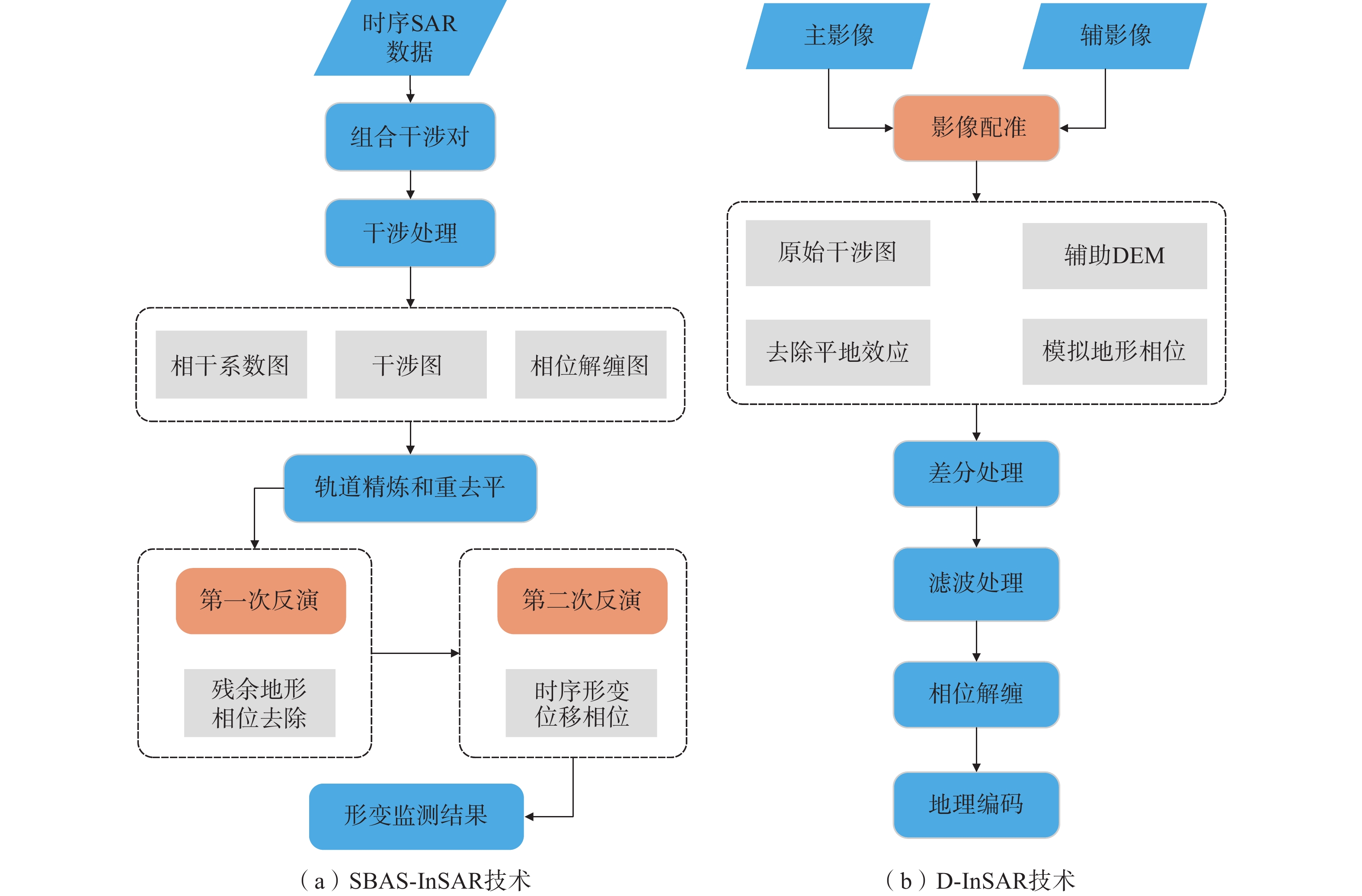
Application of multiple InSAR techniques and SAR data from multi-sources to landslide deformation monitoring: A case study of the Zhixincun landslide in Jilin Province
-
摘要:
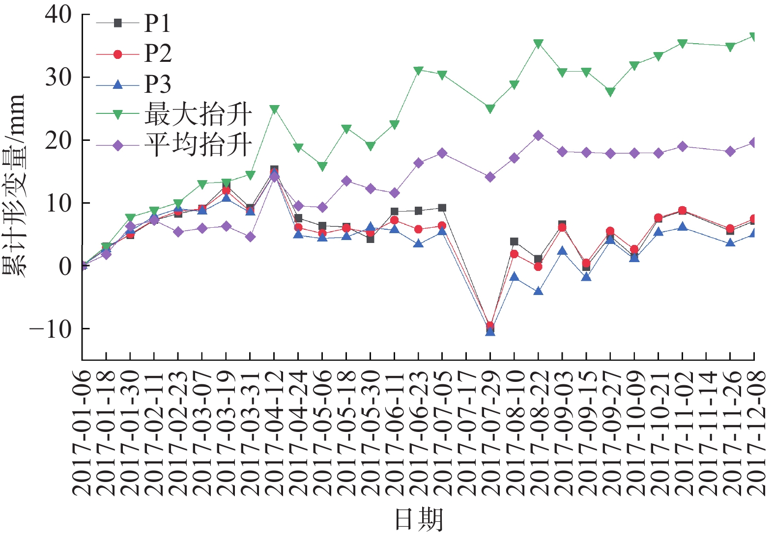
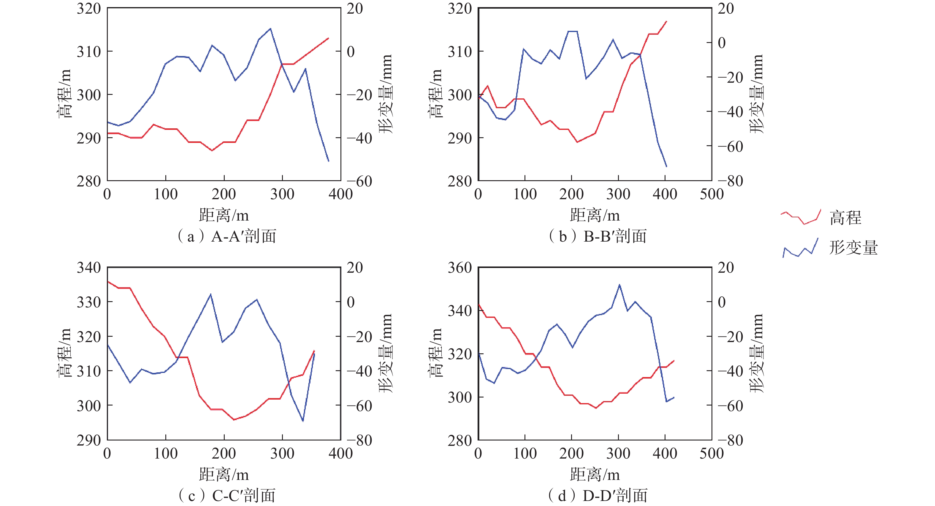
为实现对吉林省治新村滑坡的有效监测,文章选取2017年27景Sentinel-1A数据,基于小基线雷达干涉测量技术(SBAS-InSAR)对治新村滑坡进行形变监测,分析了其时序演化态势。选用2016、2017年2景ALOS-2数据,采用差分雷达干涉测量技术(D-InSAR)监测了该滑坡形变体的特征。SBAS-InSAR对滑坡形变时序演化态势进行监测,而D-InSAR则主要对滑坡具体的形变体进行形变监测,且L波段的ALOS-2数据穿透性强于C波段的Sentinel-1A数据,可以获得更完整的干涉信息,两者监测结果可交叉验证,提高结果的可靠性。SBAS-InSAR监测结果表明:治新村滑坡汇水区滑坡后缘在监测期间发生了沉降,并且在2017年7月5—29日期间滑坡后缘地表沉降达12.47 mm,监测期间平均沉降速率为2.88 mm/a;位于山谷的受威胁居民区发生了抬升,至2017年12月8日平均累计抬升达19.59 mm,监测期间平均抬升速率19.99 mm/a。D-InSAR结果显示:治新村滑坡汇水区斜坡存在5处主要变形体,面积最大变形体17973 m2,位于西侧斜坡,最不稳定变形体位于斜坡东侧,监测期间平均累计形变量最大达49.9 mm。两种监测方法都表明,滑坡灾害威胁主要来自植被覆盖较差的西侧斜坡,雨季是治新村滑坡灾害防治的重点时期。
-
关键词:
- 滑坡 /
- 治新村 /
- SBAS-InSAR /
- D-InSAR /
- ALOS-2 /
- Sentinel-1A
Abstract:In order to realize effective monitoring of Zhixincun landslide, this paper selected 27 sentinel-1A data in 2017, and conducted deformation monitoring of Zhixincun landslide based on small baseline radar interferometry technology (SBAS-InSAR), and analyzed its temporal evolution situation. Using ALOS-2 data from 2016 and 2017, differential radar interferometry (D-InSAR) was used to monitor the characteristics of the landslide variant. SBAS-InSAR monitors the temporal evolution situation of landslide deformation, while D-InSAR mainly monitors the deformation of specific landslide shape and variation. Moreover, the penetration of L-band ALOS-2 data is stronger than that of C-band sentinel-1A data, which can obtain more complete interference information. The monitoring results of both can be cross-verified. Improve the reliability of the results. The SBAS-InSAR monitoring results showed that the slope end of the landslide catchment area in Zhixincun had subsidence during the monitoring period, and the surface subsidence at the landslide end reached 12.47mm from July 5 to July 29, with an average subsidence rate of 2.88mm/a during the monitoring period. Uplift occurred in the threatened residential areas in the valley, with an average cumulative uplift of 19.59mm on December 8 and an average uplift rate of 19.99mm/a during the monitoring period. The D-InSAR results showed that there were five major deformations on the slope of Zhixincun landslide catchment area. The largest deformations with an area of 17 973m2 were located on the west side of the slope, and the most unstable deformations were located on the east side of the slope. The average cumulative shape variable reached 49.9mm during the monitoring period. Both monitoring methods showed that the threat of landslide disaster mainly came from the west slope with poor vegetation cover, and the rainy season was the key period of landslide disaster prevention and control in Zhixincun.
-
Keywords:
- landslide /
- Zhixincun /
- SBAS-InSAR /
- D-InSAR /
- ALOS-2 /
- Sentinel-1A
-
0. 引 言
近年来随着国家经济发展战略重心逐渐向中西部偏移,西南地区基础建设快速发展。由于西南地区特殊的地理环境和气候条件,兴建的市政工程频繁涉及到边坡问题[1-2],人类工程活动和降雨耦合诱发边坡失稳频发,对人民的生命财产造成严重威胁。
边坡的变形与破坏属于渐进破坏演变过程[3],引起因素有边坡脚开挖。叠加强降水作用而滑动的实例很多[4],开挖和降雨对边坡变形破坏作用的案例被大量研究[5-8]。张志兼等[9]利用地理探测器分析了滑坡分布的驱动因子,揭示了人类活动逐渐成为诱发滑坡的关键因素。黄晓虎等[10]通过现场调查、人工位移监测数据、自动GPS监测数据等分析开挖和降雨对滑坡复活的影响和主次关系。裴向军等[11]基于FLAC3D数值模拟方法,研究开挖过程中坡体稳定性变化规律及滑坡启动机理。宋琨等[12]基于长时间的监测数据分析了强降雨诱发老滑坡的动态作用。李巍岳等[13]统计拟合降雨强度与历时的关系,并构建了降雨滑坡响应阈值。杨城[14]通过采用Geo-Studio 和 Midas/GTS 有限元数值模拟软件分别分析了开挖和降雨对黄土边坡的影响。
部分学者基于位移监测数据和数值模拟等手段,分析了降雨工况下,开挖边坡的变形破坏机理[15-17]。肖超等[3]基于边坡位移监测结果和数值模拟,研究了湖北湘西山区公路边坡在开挖和降雨条件下坡体变形位移的过程。徐兴华等[18]采用数值模拟和极限平衡法,分析了在坡脚开挖过程中,不同强降雨条件下路堑斜坡的饱和—非饱状态和暂态渗流场变化。吴江鹏等[19]讨论了不同开挖时步以及不同工况下的边坡稳定性系数,并探讨了该滑坡的变形破坏机理。蔡军等[20]利用FLAC3D软件分析了降雨工况下航道工程开挖边坡的渗流场,分析降雨期间边坡失稳的普遍规律。
以上研究都是讨论开挖和降雨同时进行的滑坡变形破坏机理,但是对于先开挖再连续性强降雨,开挖与降雨时间非同步耦合影响下滑坡的变形破坏机理研究较少。本文以位于万源市太平镇前进广场后山的前进广场斜坡为例,基于边坡地表位移和深部位移数据分析滑坡的变形破坏特征,结合降雨数据,对人工开挖与降雨诱发城市滑坡的形成机制进行研究,通过对诱发滑坡的因素进一步分析讨论,研究前进广场滑坡变形破坏的整个演化过程。
1. 滑坡概况
1.1 区域环境条件
万源市地区位于大巴山弧形构造中段的南侧,区内构造线展布方向多,构造以褶皱为主,断裂发育[21](图1)。区内褶皱轴线多呈弧形,岩层倾角变化频繁,并常有挠曲现象。岩石的节理裂隙较为发育。
万源市气候温和,雨量充沛,夏季降雨强度大,日最大降水量在100 mm以上。在全球变暖的背景下,青藏高原的积雪明显减少[22],夏季高原地区为下游地区提供的水汽增加,从而导致万源市在6−7月份的降雨量逐年增加。
1.2 前进广场滑坡
滑坡区为侵蚀构造中山岭脊-峡谷地形,为山前台地。研究区整体地势南高北低,地形陡缓相间,地形坡度变化较大,最低点位于滑坡区北面长征路,标高639 m,最高点位于滑坡区南面山坡,标高890 m,总体地形坡度5°~25°,地貌单元属山前坡地(图2)。
斜坡变形体总体呈“舌”状,斜坡变形分布于斜坡中下部,前缘高程约639 m,后缘高程约839 m,滑移方向334°,变形体平均厚度约30 m,体积约5.20×10⁶ m3,属大型深层土质斜坡。通过钻孔ZK02、ZK06、ZK10等(图3),滑带主要位于基覆界面,埋深10~46 m,在斜坡变形上部分布较浅,中部及下部较深,滑带土主要为含碎石粉质黏土,可塑-软塑状,结构松散。斜坡基岩滑床主要为三叠系上统须家河组地层(T3xj)砂岩。岩层产状32°∠25°~260°∠61°,岩层产状变化大(图3)。
![]() 图 3 滑坡区1-1’地质剖面图Figure 3. Engineering geological cross-section profile of landslide zone 1-1’
图 3 滑坡区1-1’地质剖面图Figure 3. Engineering geological cross-section profile of landslide zone 1-1’在坡体上顺坡向分布有3条小冲沟,西侧冲沟有小股水流,流量约0.7 L/s,其余2条小冲沟均已干涸,冲沟在雨季具有猛涨猛落的特点。
依据地下水等值线图(图4)可知,地下水从东南流向东北。坡体中部:左侧从东南流向西北流动,右侧从南流向东北流动,大致方向为从坡体右侧向坡体左侧流动;坡体前部:坡体两侧向中间流动。
2. 前进广场滑坡变形监测数据分析
2.1 变形监测
针对斜坡变形的监测主要有地表位移监测、深部位移监测和地表自动化监测3种。
本斜坡主要为土质滑坡,主要监测从变形监测和影响因素监测2方面进行。土质滑坡受外界因素影响较大,较不稳定,暴雨、地震等都能使其失稳滑移,但其滑动方向较单一,滑动范围的边界易于掌控,故对土质滑坡常采用十字形布设方法(图5)。
![]() 图 5 前进广场滑坡工程地质平面图Figure 5. Geological formation map of the landslide engineering in the Qianjin square area
图 5 前进广场滑坡工程地质平面图Figure 5. Geological formation map of the landslide engineering in the Qianjin square area2.2 数据分析
2.2.1 地表位移数据分析
地表位移监测点共布设34个,编号Q1-Q11、H01-H13、Z01-Z10,前期每6 h采集一次数据,后期减缓为12 h一次,时段降雨量监测数据同上(图6)。
(1)坡体前部
坡体前部2019年7月中旬以前主要以垂直位移为主,之后以水平位移为主;以图6(a)(b)所列数据可知,8月中旬之前水平位移呈波动增长趋势,8月中旬到9月中旬,由于坡体应力调整,水平位移有的增大有的减小,9月下旬之后,由于坡体应力调整较缓,前缘基本趋于平稳。
(2)坡体中部
坡体中部在水平位移变化速率在7月中旬前坡体的垂直和水平位移都较小,之后突然变大,垂直方向上的位移整体上呈匀速下滑趋势;水平方向上的位移整体呈减缓趋势,持续增加,在8月中旬之后水平方向上的位移明显减小。
如图6(c)(d)所示,Z05水平位移变化速率整体近线形持续增加趋势;Z06水平位移变化速率整体呈减缓趋势,持续增加;Z07水平位移变化速率整体呈缓陡缓的趋势,波动持续增加。
(3)坡体后部
坡体后部地表位移监测数据见图6(e)(f)。可知,坡体后部在7月中旬之前变化较小,之后突然增大,垂直位移的整体上以匀速下降为主,水平位移速率整体呈持续缓慢增加的趋势,在8月中旬之后,水平位移变化速率明显变缓解,局部增加较大。
H02水平位移速率整体呈波动缓慢增加的趋势;H03水平位移速率整体呈持续缓慢增加的趋势,增长的速率在减缓,局部增加较大;H04水平位移速率整体呈持续缓慢增加的趋势,增长的速率在减缓;H06水平位移速率整体呈波动缓慢增加的趋势,现已趋缓;H07水平位移速率整体呈持续缓慢增加的趋势,增长的速率在减缓,局部增加较大;H08水平位移速率整体呈持续缓慢增加的趋势,增长的速率在减缓;H09水平位移速率整体呈持续缓慢增加的趋势,呈陡缓趋势;H10水平位移速率整体呈持续缓慢增加的趋势,呈陡缓趋势。
从地表位移监测数据分析可知,坡体前部基本趋于稳定,坡体中部水平位移速率为0.39~0.5 mm/d,局部为0.75~1.36 mm/d,坡体后部右侧位移速率0.63~0.87 mm/d,坡体后部左侧位移速率0.06~0.13 mm/d,观景平台以上位移速率0.21~0.36 mm/d,因此,斜坡变形体后部存在次级剪出的可能。
2.2.2 深部位移数据分析
本次应急阶段深部位移监测孔共布设了8个点,编号IN01−IN08,目的是查明斜坡变形的滑面位置及发展趋势,与钻探数据进行相互验证(图5)。
从深部位移监测数据(图7)分析可知:
(1)坡体前部
坡体前部的滑面通过监测数据分析变化较大,IN06监测推测滑面为深47 m处,速率越来越缓,至2019年9月8日累计水平位移为20.28 mm。IN08监测推测滑面为深24 m处,该滑面呈波动较缓速率增长—渐稳趋势,至2019年9月8日累计水平位移为15.42 mm。
(2)坡体中部
坡体中部通过深部位移数据分析,推测滑面在深36.5~40 m处,滑面呈较缓速率增长(局部波动)—趋稳趋势,至2019年9月8日累计水平位移为15.5 mm。
(3)坡体后部
坡体后部从IN01到IN03,监测推测滑面由浅到深,IN01推测滑面为深16 m处,水平累计位移以较缓速率增长(局部呈波动状态),增长波动较大,至2019年9月8日增长到40.63 mm(局部波动);IN03推测滑面为深39 m处,增长不明显,至2019年9月8日累计水平位移为11.05 mm。
从深部位移监测数据分析可知,在2019年7月的监测中,坡体后部的累计位移变化量最大且平均位移速率最快,相比较中部累计变化量较小,平均位移速率较慢。而在2019年8月的监测中,坡体中后6-6’剖面处的累计位移变化量最大且平均位移速率最快,相比较后部累计变化量较小,平均位移速率较慢。故蒋家院子和钟家院子平台后部较陡斜坡体,在陡缓交界处有次级剪出的可能。
2.2.3 降雨数据分析
从日降雨情况看,在2019年6月份以前主要以小雨为主,且降雨较分散,6月以后降雨明显增多,大雨和暴雨频次明显增多,且降雨较集中。据调查,前缘鼓胀裂缝、斜坡裂缝和房屋开裂变形,主要集中在2019年6月底。
连续降雨导致地下水水位变化,根据水位监测情况(图8),坡体中、上部地下水位基本无变化,坡体中下部斜坡变形西半侧水位有所浮动(幅值1.5~2.0 m),东半侧水位基本无变化,坡体下部地下水位基本无变化,由此可知,该坡体渗透性较大,排泄快的特点。由此可知,该坡体中下部地下水丰富,且具有一定的承压性。
3. 前进广场滑坡成因机制讨论
该斜坡变形稳定性影响因素受多种因素控制,主要从地形地貌、地层岩性、人类工程活动和降雨等因素进行分析。
3.1 控制因素分析
(1)地形地貌
斜坡变形整体地势南高北低,地形陡缓相间,地形坡度变化较大,整体呈“缓-陡-缓-陡-缓”的特点,地形坡度5°~25°,均坡度20°,斜坡变形后缘高与前缘高程相对高差约200 m,斜坡变形纵向长约640 m,横向宽约270 m,斜坡变形两侧发育小型冲沟,地形较复杂,为滑坡形成提供了较好的地形条件。
(2)地层岩性
该斜坡为一个老滑坡,地质结构脆弱。斜坡变形体主要由第四系块石土、碎石及角砾组成,粉质黏土充填,块石大小分布不均匀,最大可达5 m,坡体结构较松散,架空现象严重,且含碎石粉质黏土成层分布,连续性较好,下伏基岩为砂岩,透水性弱,为斜坡滑动提供了必要的物质条件。
3.2 影响因素分析
(1)人类工程活动
2019年4月,斜坡前缘棚户区改造基坑开始进行开挖,2019年4月中旬出现少量裂缝。据调查,前缘下部抗滑桩与板已脱离较长时间,说明该斜坡局部处于欠稳定状态,坡体处于不断调整应力的状态。同年3—7月,基坑监测单位对周边房屋监测的水平位移累计值已经大大超出了预警值。
斜坡在原始地形时,推测斜坡处于欠稳定状态。由于斜坡前缘基坑开挖,相当于对斜坡进行前缘减载,基坑开挖后,该斜坡处于极限平衡状态;斜坡长期处于该状态,坡体应力重分布,前缘基坑的开挖不断持续,由于坡体变形补偿,引起斜坡后部应力不断调整,最终促使斜坡变形出现剪切带,应力调整促使斜坡变形剪切带形成也会导致抗剪强度的降低,诱发斜坡变形失稳。
(2)降雨
不少研究表明[23-24] ,降雨是滑坡失稳诱因中最常见和最活跃的诱发因素之一,长时间的强降雨不仅仅在降雨时影响坡体稳定性且在结束后较长时间会持续影响坡体稳定性[25]。
据统计,万源市夏季降雨强度大,日最大降水量在100 mm以上(图9),从坡体地表位移监测与该时段降雨量关系图(图6)可知,坡体与降雨变形具有明显的对应性,在强降雨或者持续性降雨期间,多个地表位移监测点出现位移加速的现象,且深部位移监测孔也开始出现疑似滑面。
![]() 图 9 前进广场滑坡演化模式图Figure 9. The evolutionary pattern of landslide in the Qianjin square area
图 9 前进广场滑坡演化模式图Figure 9. The evolutionary pattern of landslide in the Qianjin square area综上所述,人工开挖和连续降雨且降雨强度较大是斜坡变形稳定性的主要影响因素。
3.3 时空变形特征析
结合地表位移监测数据、深部位移监测数据以及时段降雨数据分析,自2019年4月斜坡前缘棚户区改造基坑开始进行开挖,后方土体失去支撑,同时由于基岩裂隙水不断受到大气降雨的补给,斜坡上部的基岩裂隙水又不断补给中部和下部的第四系松散层潜水,导致部分非饱和土变为饱和土,有效应力降低,滑面参数降低,发生蠕变,同时也有少量地表水下渗至滑体内,形成张拉裂缝后,地表水更容易直接进入坡体内部,促进斜坡变形加速发展。2019年6月,随着基坑开挖深度不断加大,日段降雨量持续增加,最终导致老滑坡复活。
在雨季来临前,斜坡处于较稳定状态,进入雨季后,斜坡逐渐产生裂缝变形,由此可见降雨是诱发本次滑坡的因素之一。在基坑工程开挖前,3月份左右斜坡裂缝并未产生,4月份动工后,少量裂缝逐渐显现,斜坡发生局部变形,证明此时斜坡已处于不稳定状态。由此可见人类工程活动和降雨构成了滑坡产生变形破坏的主要因素。
3.4 人类活动和降雨耦合诱发滑坡过程机制
从地形上看,该斜坡地形“陡-缓-陡”的特征,形成多级台地;从斜坡变形特征分析,斜坡变形中部拉张裂缝较发育,且其走向基本与滑动方向垂直,多条张拉裂缝可见明显下错,裂缝发育特征符合推移式的典型特征。从裂缝形成时间来看,裂缝发育过程与基坑开挖卸荷时间基本一致。另外前进广场出现大量鼓胀裂缝。从监测数据分析可知,总体斜坡变形体呈现后部大于中部、中部大于前部、广场区大于基坑区的特点,体现出在该阶段斜坡变形不断从上向下推挤,并存在转向推挤的现象。综合分析,该斜坡变形破坏模式主要为推移式[26]。
滑坡区坡体后部地下水以基岩裂隙水为主,坡体中部和前部为第四系潜水层(图5),由于局部存在粉质黏土分布,且局部承压,一方面增大了滑带土孔隙水压力[27],有效应力降低,从而降低滑带土抗剪强度,另一方面,承压水对滑带土形成的扬压力对斜坡变形稳定性也有较大影响;由于土体含较多粉质黏土等细粒成分,透水性相对较差,地表水下渗量小,但也不容忽视,特别是在裂缝开始形成后,导致地表水下渗量不断增大,将加速斜坡变形的发展。
据此,将滑坡破坏可分为3个阶段(图9)。第一阶段:本滑坡在人工开挖坡脚的作用下,在坡体前方产生局部变形,坡体内部的主应力向临空方向集中,从而使得坡体中后缘与后缘形成多条张拉裂缝,为雨水入渗创造了有利条件。第二阶段:降雨后雨水与地表水顺着裂缝进入坡体,一方面让斜坡土体自重增大,导致坡体下滑力增强,另一方面大量水分入渗使土体软化,部分非饱和土变为饱和土,有效应力降低,从而降低滑带土抗剪强度,同时承压水对滑带土形成的扬压力降低了斜坡变形稳定性,斜坡内部裂缝持续往下扩展。第三阶段:坡体由局部破坏逐渐演变成大变形直至发生整体破坏,当在降雨量达到峰值时,整体的破坏使得后部土体抗剪强度进一步降低,从而在后部发生表层松散体的破坏。
4. 结 论
本文基于地表位移监测数据、深部位移监测数据以及降雨数据对前进广场滑坡的变形特征进行分析,得到了以下成果:
(1)该斜坡地形“陡-缓-陡”的特征,形成多级台地,根据深部位移监测数据分析,监测滑面大致位于基覆界面位置,埋深在10~46 m不等,在斜坡变形上部分布较浅,中部及下部较深,结合斜坡变形特征,推测前进广场滑坡属于推移式滑坡。
(2)依据地表位移监测数据和变形迹象可知,坡体中部水平位移速率为0.39~0.5 mm/d,局部为0.75~1.36 mm/d,坡体后部右侧位移速率0.63~0.87 mm/d,斜坡变形体后部及中部陡缓交界处有次级剪出的可能,暴雨工况下稳定性差。
(3)滑坡形成原因受多种因素影响,主要是人工开挖与降雨耦合,前缘基坑的开挖是导致老滑坡复活最主要的原因,降雨起到了激发和加速作用。
(4)滑坡的形成演化模式为:前缘棚户区改造基坑开挖卸荷,一方面为边坡提供了良好的临空面,另一方面后方土体失去支撑。同时由于基岩裂隙水不断受到大气降雨的补给,部分饱和土变成不饱和土,有效应力降低,滑面参数降低,发生蠕变,同时也有少量地表水下渗至滑体内,形成张拉裂缝后,地表水更容易直接进入坡体内部,促进斜坡变形加速发展。随着基坑开挖深度不断加大,降雨量持续增加,最终导致老滑坡复活。
-
![]()
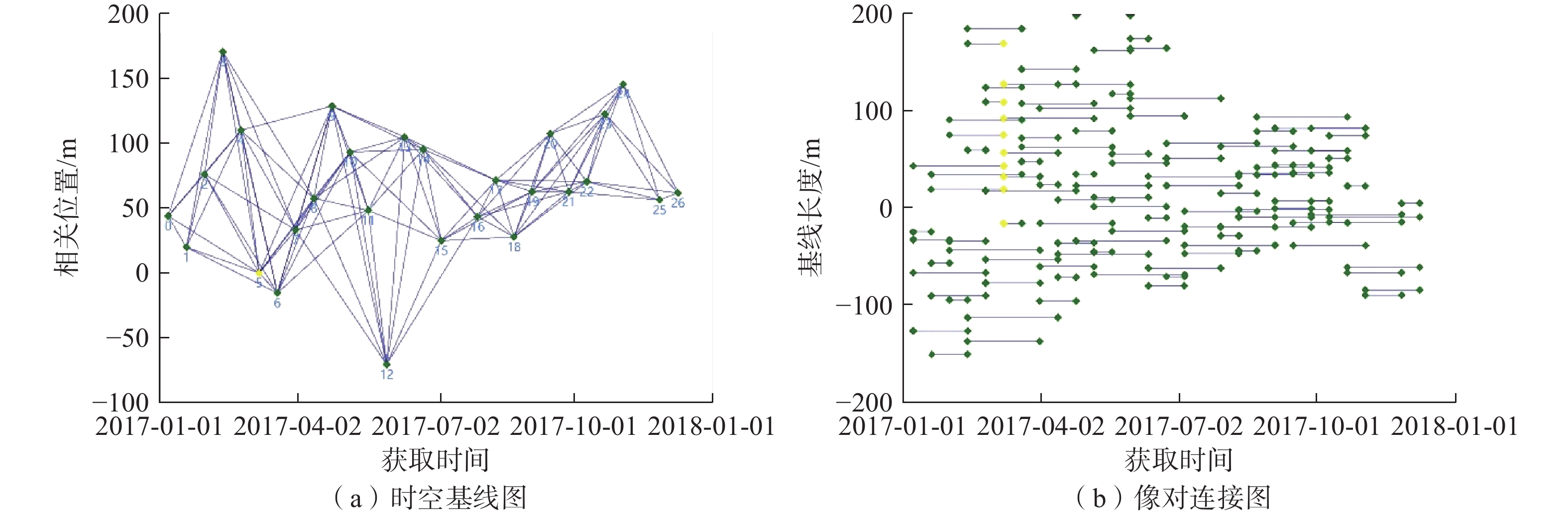
图 3 SBAS-InSAR时空基线图与像对连接图
Figure 3. SBAS-InSAR space-time baseline diagram and image pair connection diagram
![]()
图 5 SBAS-InSAR监测点时序特征
Figure 5. Temporal characteristics of SBAS-InSAR monitoring points
表 1 Sentinel-1A数据集
Table 1 Sentinel-1A data set
序号 成像日期 时间基线/d 空间基线/m 01 2017-01-06 60 43.8 02 2017-01-18 48 19.9 03 2017-01-30 36 75.9 04 2017-02-11 24 170.1 05 2017-02-23 12 109.8 06 2017-03-07 0 0 07 2017-03-19 12 −15.5 08 2017-03-31 24 32.9 09 2017-04-12 36 57.4 10 2017-04-24 48 128.3 11 2017-05-06 60 92.7 12 2017-05-18 72 47.9 13 2017-05-30 84 −70.3 14 2017-06-11 96 104.5 15 2017-06-23 108 95.2 16 2017-07-05 120 25.1 17 2017-07-29 144 43.2 18 2017-08-10 156 71.3 19 2017-08-22 168 27.8 20 2017-09-03 180 62.6 21 2017-09-15 192 107.1 22 2017-09-27 204 62.3 23 2017-10-09 216 70.1 24 2017-10-21 228 122.2 25 2017-11-02 240 145.3 26 2017-11-26 264 56.1 27 2017-12-08 276 61.5  下载: 导出CSV
表 2 ALOS-2影像信息
Table 2 ALOS-2 image information
序号 成像日期 时间基线/d 空间基线/m 01 2016-07-26 392 −225.5 02 2017-08-22
下载: 导出CSV
表 3 斜坡变形体
Table 3 Deformation of slope
编号 面积/m² 最大沉降量/mm 最小沉降量/mm 平均沉降量/mm 1 5318 58.6 29.4 43.2 2 17973 50.6 24.2 36.4 3 4636 68.7 29.8 43.5 4 3043 71.8 31.3 49.9 5 11281 47.6 20.1 38.3
下载: 导出CSV
-
[1] 殷跃平,王文沛. 高位远程滑坡动力侵蚀犁切计算模型研究[J]. 岩石力学与工程学报,2020,39(8):1513 − 1521. [YIN Yueping,WANG Wenpei. Study on calculation model of dynamic erosion plowing of high-level remote landslide[J]. Chinese Journal of Rock Mechanics and Engineering,2020,39(8):1513 − 1521. (in Chinese with English abstract) Yin Yueping, Wang Wenpei. Study on calculation model of dynamic erosion plowing of high-level remote landslide[J]. Chinese Journal of Rock Mechanics and Engineering, 2020, 39(8): 1513-1521. (in Chinese with English abstract)
[2] 黄海峰,林海玉,吕奕铭,等. 基于小型无人机遥感的单体地质灾害应急调查方法与实践[J]. 工程地质学报,2017,25(2):447 − 454. [HUANG Haifeng,LIN Haiyu,LYU Yiming,et al. Micro unmanned aerial vehicle based remote sensing method and application for emergency survey of individual geohazard[J]. Journal of Engineering Geology,2017,25(2):447 − 454. (in Chinese with English abstract) HUANG Haifeng, LIN Haiyu, LYU Yiming, et al. Micro unmanned aerial vehicle based remote sensing method and application for emergency survey of individual geohazard[J]. Journal of Engineering Geology, 2017, 25(2): 447-454. (in Chinese with English abstract)
[3] 朱庆,曾浩炜,丁雨淋,等. 重大滑坡隐患分析方法综述[J]. 测绘学报,2019,48(12):1551 − 1561. [ZHU Qing,ZENG Haowei,DING Yulin,et al. A review of major potential landslide hazards analysis[J]. Acta Geodaetica et Cartographica Sinica,2019,48(12):1551 − 1561. (in Chinese with English abstract) ZHU Qing, ZENG Haowei, DING Yulin, et al. A review of major potential landslide hazards analysis[J]. Acta Geodaetica et Cartographica Sinica, 2019, 48(12): 1551-1561. (in Chinese with English abstract)
[4] 张勤,黄观文,杨成生. 地质灾害监测预警中的精密空间对地观测技术[J]. 测绘学报,2017,46(10):1300 − 1307. [ZHANG Qin,HUANG Guanwen,YANG Chengsheng. Precision space observation technique for geological hazard monitoring and early warning[J]. Acta Geodaetica et Cartographica Sinica,2017,46(10):1300 − 1307. (in Chinese with English abstract) DOI: 10.11947/j.AGCS.2017.20170453 ZHANG Qin, HUANG Guanwen, YANG Chengsheng. Precision space observation technique for geological hazard monitoring and early warning[J]. Acta Geodaetica et Cartographica Sinica, 2017, 46(10): 1300-1307. (in Chinese with English abstract) DOI: 10.11947/j.AGCS.2017.20170453
[5] 刘文,王猛,朱赛楠,等. 基于光学遥感技术的高山极高山区高位地质灾害链式特征分析—以金沙江上游典型堵江滑坡为例[J]. 中国地质灾害与防治学报,2021,32(5):29 − 39. [LIU Wen,WANG Meng,ZHU Sainan,et al. An analysis on chain characteristics of highstand geological disasters in high mountains and extremely high mountains based on optical remote sensing technology:A case study of representative large landslides in upper reach of Jinsha River[J]. The Chinese Journal of Geological Hazard and Control,2021,32(5):29 − 39. (in Chinese with English abstract) LIU Wen, WANG Meng, ZHU Sainan, et al. An analysis on chain characteristics of highstand geological disasters in high mountains and extremely high mountains based on optical remote sensing technology: a case study of representative large landslides in upper reach of Jinsha River[J]. The Chinese Journal of Geological Hazard and Control, 2021, 32(5): 29-39. (in Chinese with English abstract)
[6] XIE Mingli,ZHAO Weihua,JU Nengpan,et al. Landslide evolution assessment based on InSAR and real-time monitoring of a large reactivated landslide,Wenchuan,China[J]. Engineering Geology,2020,277:105781. DOI: 10.1016/j.enggeo.2020.105781
[7] 王洵,周云,孙蒙,等. 青海玉树Mw6.9级地震震源破裂过程[J]. 地质通报,2014,33(4):517 − 523. [WANG Xun,ZHOU Yun,SUN Meng,et al. Rupture process of the 2010 Mw6.9 Yushu earthquake in Qinghai Province[J]. Geological Bulletin of China,2014,33(4):517 − 523. (in Chinese with English abstract) WANG Xun, ZHOU Yun, SUN Meng, et al. Rupture process of the 2010 Mw6.9 Yushu earthquake in Qinghai Province[J]. Geological Bulletin of China, 2014, 33(4): 517-523. (in Chinese with English abstract)
[8] 刘星洪,姚鑫,周振凯,等. 滑坡灾害InSAR应急排查技术方法研究[J]. 地质力学学报,2018,24(2):229 − 237. [LIU Xinghong,YAO Xin,ZHOU Zhenkai,et al. Study of the technique for landslide rapid recognition by InSAR[J]. Journal of Geomechanics,2018,24(2):229 − 237. (in Chinese with English abstract) LIU Xinghong, YAO Xin, ZHOU Zhenkai, et al. Study of the technique for landslide rapid recognition by insar[J]. Journal of Geomechanics, 2018, 24(2): 229-237. (in Chinese with English abstract)
[9] 张佳佳,田尤,陈龙,等. 澜沧江昌都段滑坡发育特征及形成机制[J]. 地质通报,2021,40(12):2024 − 2033. [ZHANG Jiajia,TIAN You,CHEN Long,et al. Development and formation mechanism of landslides along Changdu section of Lancang River[J]. Geological Bulletin of China,2021,40(12):2024 − 2033. (in Chinese with English abstract) ZHANG Jiajia, TIAN You, CHEN Long, et al. Development and formation mechanism of landslides along Changdu section of Lancang River[J]. Geological Bulletin of China, 2021, 40(12): 2024-2033. (in Chinese with English abstract)
[10] 许军强,马涛,卢意恺,等. 基于SBAS-InSAR技术的豫北平原地面沉降监测[J]. 吉林大学学报(地球科学版),2019,49(4):1182 − 1191. [XU Junqiang,MA Tao,LU Yikai,et al. Land subsidence monitoring in North Henan plain based on SBAS-InSAR technology[J]. Journal of Jilin University (Earth Science Edition),2019,49(4):1182 − 1191. (in Chinese with English abstract) XU Junqiang, MA Tao, LU Yikai, et al. Land subsidence monitoring in North Henan plain based on SBAS-InSAR technology[J]. Journal of Jilin University (Earth Science Edition), 2019, 49(4): 1182-1191. (in Chinese with English abstract)
[11] FRUNEAU B,ACHACHE J,DELACOURT C. Observation and modelling of the Saint-Étienne-de-Tinée landslide using SAR interferometry[J]. Tectonophysics,1996,265(3/4):181 − 190.
[12] MADSEN S N,ZEBKER H A,MARTIN J. Topographic mapping using radar interferometry:processing techniques[J]. IEEE Transactions on Geoscience and Remote Sensing,1993,31(1):246 − 256. DOI: 10.1109/36.210464
[13] 邓云凯,禹卫东,张衡,等. 未来星载SAR技术发展趋势[J]. 雷达学报,2020,9(1):1 − 33. [DENG Yunkai,YU Weidong,ZHANG Heng,et al. Forthcoming spaceborne SAR development[J]. Journal of Radars,2020,9(1):1 − 33. (in Chinese with English abstract) DENG Yunkai, YU Weidong, ZHANG Heng, et al. Forthcoming spaceborne SAR development[J]. Journal of Radars, 2020, 9(1): 1-33. (in Chinese with English abstract)
[14] FERRETTI A, PRATI C, ROCCA F. Permanent scatterers in SAR interferometry[C]//IEEE Transactions on Geoscience and Remote Sensing. January 2001, IEEE, 2002: 8 − 20.
[15] BERARDINO P,FORNARO G,LANARI R,et al. A new algorithm for surface deformation monitoring based on small baseline differential SAR interferograms[J]. IEEE Transactions on Geoscience and Remote Sensing,2002,40(11):2375 − 2383. DOI: 10.1109/TGRS.2002.803792
[16] 姚佳明,姚鑫,陈剑,等. 基于InSAR技术的缓倾煤层开采诱发顺层岩体地表变形模式研究[J]. 水文地质工程地质,2020,47(3):135 − 146. [YAO Jiaming,YAO Xin,CHEN Jian,et al. A study of deformation mode and formation mechanism of a bedding landslide induced by mining of gently inclined coal seam based on InSAR technology[J]. Hydrogeology & Engineering Geology,2020,47(3):135 − 146. (in Chinese with English abstract) DOI: 10.16030/j.cnki.issn.1000-3665.201903072 YAO Jiaming, YAO Xin, CHEN Jian, et al. A study of deformation mode and formation mechanism of a bedding landslide induced by mining of gently inclined coal seam based on InSAR technology[J]. Hydrogeology & Engineering Geology, 2020, 47(3): 135-146. (in Chinese with English abstract) DOI: 10.16030/j.cnki.issn.1000-3665.201903072
[17] 赵富萌,张毅,孟兴民,等. 基于小基线集雷达干涉测量的中巴公路盖孜河谷地质灾害早期识别[J]. 水文地质工程地质,2020,47(1):142 − 152. [ZHAO Fumeng,ZHANG Yi,MENG Xingmin,et al. Early identification of geological hazards in the Gaizi valley near the Karakoran highway based on SBAS-InSAR technology[J]. Hydrogeology & Engineering Geology,2020,47(1):142 − 152. (in Chinese with English abstract) ZHAO Fumeng, ZHANG Yi, MENG Xingmin, et al. Early identification of geological hazards in the Gaizi valley near the Karakoran Highway based on SBAS-InSAR technology[J]. Hydrogeology & Engineering Geology, 2020, 47(1): 142-152. (in Chinese with English abstract)
[18] ZHANG Y,MENG X M,DIJKSTRA T A,et al. Forecasting the magnitude of potential landslides based on InSAR techniques[J]. Remote Sensing of Environment,2020,241:111738. DOI: 10.1016/j.rse.2020.111738
[19] 季灵运,王庆良,崔笃信,等. 利用SBAS-DInSAR技术提取腾冲火山区形变时间序列[J]. 大地测量与地球动力学,2011,31(4):149 − 153. [JI Lingyun,WANG Qingliang,CUI Duxin,et al. Time series of deformation in Tengchong volcanic area extracted by SBAS-DInSAR[J]. Journal of Geodesy and Geodynamics,2011,31(4):149 − 153. (in Chinese with English abstract) DOI: 10.3969/j.issn.1671-5942.2011.04.034 JI Lingyun, WANG Qingliang, CUI Duxin, et al. Time series of deformation in Tengchong volcanic area extracted by sbas-dinsar[J]. Journal of Geodesy and Geodynamics, 2011, 31(4): 149-153. (in Chinese with English abstract) DOI: 10.3969/j.issn.1671-5942.2011.04.034
[20] 葛伟丽,李元杰,张春明,等. 基于InSAR技术的内蒙古巴彦淖尔市地面沉降演化特征及成因分析[J]. 水文地质工程地质,2022,49(4):198 − 206. [GE Weili,LI Yuanjie,ZHANG Chunming,et al. An attribution analysis of land subsidence features in the city of Bayannur in Inner Mongolia based on InSAR[J]. Hydrogeology & Engineering Geology,2022,49(4):198 − 206. (in Chinese with English abstract) GE Weili, LI Yuanjie, ZHANG Chunming, et al. An attribution analysis of land subsidence features in the city of Bayannur in Inner Mongolia based on InSAR[J]. Hydrogeology & Engineering Geology, 2022, 49(4): 198-206. (in Chinese with English abstract)
-
期刊类型引用(11)
1. 邱明明,李晓敏,杨果林,段君义. 挡墙渗漏对富水砂层基坑变形性状的影响. 水文地质工程地质. 2025(01): 85-96 .  百度学术
百度学术
2. 字汝芬,刘佳佳,王宇鸿,段平,李佳. 云南鲁甸M_s6.5级地震震后滑坡的时空分异特征. 中国地质灾害与防治学报. 2025(01): 73-83 . 本站查看
3. 徐兴安. 富水软岩地段隧道明洞施工阶段对多级边坡稳定性影响研究. 中国设备工程. 2024(13): 255-258 . 百度学术
4. 段中满,张莉华,薛云,何明,陈吉祥. 湖南省地质灾害发生与降水的耦合关系研究. 矿产勘查. 2024(07): 1310-1317 . 百度学术
5. 覃尚文,郭鹏飞. 强降雨作用下含软弱带填方边坡稳定性影响因素分析. 河南科学. 2024(08): 1145-1152 . 百度学术
6. 赖国泉,焦海平. 井-孔联合疏排高填方滑坡地下水典型案例分析. 中国地质灾害与防治学报. 2024(04): 106-114 . 本站查看
7. 黄朝阳. 宁德白莲寺后山滑坡成因分析及综合治理. 岩土工程技术. 2024(05): 577-583 . 百度学术
8. 张昊天,王新刚,罗力,王友林,郭倩怡,薛晨. 秦巴山区典型碎石土抗剪强度变化规律及其在堆积层滑坡机理分析中的应用. 中国地质灾害与防治学报. 2024(05): 50-58 . 本站查看
9. 马昕,孙德安,刘树佳. 软土地区某超深圆形基坑变形特性及流固耦合分析. 水文地质工程地质. 2024(06): 74-85 . 百度学术
10. 蔡鸿宇,王运敏,李小双,耿加波. 开挖卸荷与孔隙水压耦合作用下千枚岩蠕变力学特性研究. 黄金科学技术. 2024(06): 1016-1029 . 百度学术
11. 吕霞,范刚,刘大瑞,林子钰. 斜坡降雨侵蚀破坏机理现场试验研究——以四川甘洛黑西洛沟滑坡-泥石流残留边坡为例. 中国地质灾害与防治学报. 2024(06): 82-89 . 本站查看
其他类型引用(0)


计量
- 文章访问数: 1390
- HTML全文浏览量: 1313
- PDF下载量: 347
- 被引次数: 11
 邮件订阅
邮件订阅 RSS
RSS