

Comprehensive analysis of hazardous rock mass and simulation of potential rockfall processes using 3D terrain model: A case studyof the high cut slope near damsite of a hydropower stationin southern China
-
摘要: 西南山区水电站两侧陡峻边坡发育有大量危岩体,危岩体滚动滑落、崩塌掉块等现象给电站的大坝、主要建筑物、厂房、道路、支护边坡等的正常运营带来了很大影响。现阶段针对危岩崩塌灾害的预测和防护多是忽略危岩体空间几何形状的二维Rockfall方法和人为截取优势剖面,但实际落石为三维运动,其威胁区域为一个地理上的三维空间。鉴于此,以西南某水电站危岩体隐患排查结果为基础,采用现场调查,机载LiDAR遥感测量技术和无人机倾斜摄影技术,获取研究区高精度的激光雷达点云数据,构建精细危岩体模型和真实三维实景模型,进行历史崩塌落石分布特征、岩体结构产状及崩塌源区危岩体特征和危岩体失稳模式的分析,结合Unity3D三维落石分析方法进行危岩崩落后的运动特征模拟,实现危岩崩落的运动路径及在不同位置上的弹跳高度、冲击能量和滚落区域等参数的获取。结果表明:水电站右岸危岩区块一典型危岩体的弹跳高度最大可达7.92 m,影响范围约145 m,多滚落至大坝,已设置多级被动防护网,不会对电厂内重要设施构成威胁,右岸危岩区块二发育的危岩体崩落后,落石影响范围约为120 m,部分落石会沿着公路护坡滚动到道路上,可能威胁交通要道;左岸危岩区块一发育典型危岩体体积巨大,稳定性差,其崩落后最大弹跳高度可达9.02 m,最终会落入水库蓄水区;左岸危岩区块二危岩分布密集,数量多,崩落后影响范围约为380 m,但受坡表植被茂密的影响,多数落石停积在坡表,对行人车辆有一定的威胁。相关研究成果可为类似水电设施危岩体隐患识别与落石运动模拟提供一定的参考。Abstract: The steep slopes on both sides of the hydropower station in the southwestern mountainous region develop a multitude of dangerous rock formations. The rolling, collapsing and falling of these hazardous rocks have profound implications on the normal operation of the dam, main buildings, factories, roadways, and slope support systems. At present, the prediction and protection measures against rockfall disasters are predominantly reply on the two-dimensional Rockfall method, which ignores the spatial geometry of these dangerous rocks. In reality, falling rockfalls exhibit three-dimensional motion, and their threat zone extends throughout a three-dimensional geographical space. In view of this, this study is based on the hazard assessment results of the hidden danger investigation in a specific hydropower station of Yunnan Province. It employs field investigations, airborne LiDAR remote sensing measurement technology, and unmanned aerial vehicle (UAV) oblique photography technology to obtain high-precision laser radar point cloud data for the study area. This data is used to constrct detailed rock mass models and authentic three-dimensional scene models. The analysis includes historical rockfall distribution characteristics, rock mass structural characteristics, characteristics of hazardous rock masses in collapse source areas, and unstable modes. Furthermore, the study utilizes Unity3D three-dimensional rockfall analysis methods to simulate the motion characteristics of dangerous falling rocks after collapse. This enables the determination of the trajectory of dangerous falling rocks, as well as parameters such as bounce height, impact energy, and rolling area at different locations. The results indicate that for the right bank dangerous rock area of the hydropower station, a typical dangerous rock mass can achieve a maximum bounce height of up to 7.92 meters, with an impact range of approximately 145 meters. Most of these rocks roll towards the dam, which has multiple levels of passive protection nets and does not pose a threat to important facilities within the power plant. In the case of the right bank dangerous rock area two, after the collapse of dangerous rocks masses, the impact range of the falling rocks is approximately 120 meters, and some of the falling rocks may roll along the road embankment onto the road, potentially posing a threat to the main traffic artery. On the left bank, dangerous rock area one has a massive and unstable typical rock mass, with a maximum bounce height of up to 9.02 meters, ultimately falling into the reservoir storage area. Hazardous rock area two on the left bank has a dense distribution of hazardous rock masses, with a significant quantity, and after collapse, the impact range is approximately 380 meters. However, due to the dense vegetation cover on the slope, most of the falling rocks accumulate on the slope surface, posing a certain threat to pedestrians and vehicles. The related research results can provide valuable insights for the identification of hazardous rock masses and simulation of rockfall events in similar hydropower facilities.
-
Keywords:
- dangerous rock mass /
- rock fall /
- motion simulation /
- UAV /
- Unity3D
-
0. 引言
某水电站自建成以来重要建筑物开口线外危岩体缺乏复核和动态设计,其原有防护设施存在破坏现象,导致部分重要设施暴露于危险源的威胁范围内(主要危险源为两岸开口线外危岩体),因此开展该水电站边坡开口线外的危岩体隐患排查对电站安全运营有着重大意义。
危岩体隐患排查首先要明确危岩体的点位、体积、结构面组合关系和威胁对象等信息。针对水电站库区复杂险峻的地质条件,传统现场调查方法受人员、技术、成本等条件限制,诸多非接触式的新技术、新方法应用于工程调查中,如黄海宁等[1]利用无人机倾斜摄影技术,获取危岩隐患点的分布特征;陈爱云等[2]和崔溦等[3]利用无人机搭载激光雷达快速识别了孤立危岩体;褚宏亮等[4]分析三维激光扫描技术的优势和局限性。危岩体的精细调查结果对进一步研究危岩体运动特征有重要的推动作用。
现有研究危岩体运动特征的方法主要有现场试验和数值模拟方法,如黄润秋等[5]通过现场滚石运动特征试验,提出危岩体整体防治的可行方法,得出坡面及坡面情况为影响落石运动的主要因素这一论点;陈宙翔等[6]和谢金等[7]利用Rockfall软件分析危岩体崩落的运动轨迹及对坡脚建筑物的危险性;王栋等[8]利用三维Rockfall Analyst软件分析隧道上部5种不同尺寸的危岩体运动过程;周月智等[9]运用DDA方法实现地震作用下密度、高度等因子对落石运动轨迹的影响分析;黎尤等[10]结合RocPro3D软件反演落石崩塌堆积区的范围,并与既有实际范围进行比照;柳万里等[11]通过Rockfall软件大量模拟落石运动结果,分析影响落石运动的因素敏感性;赵兴权等[12]和黄小福等[13]结合非连续分析方法探讨地震作用下危岩崩塌体的破坏特征;刘国阳等[14]通过3D-DDA方法研究不同坡形对巨石崩塌失稳运动特征的影响;王军义等[15]通过数值仿真模拟试验评价不同粒径堆积体的运动特征;孙敬辉等[16]和何宇航等[17]探讨崩塌落石的运动特征,进行落石风险评估研究;王豪等[18]提出一种集成PhysX引擎的Unity3D平台开展崩塌三维运动轨迹的方法。
综上,现场试验方法与实际落石运动结果吻合度最高,但落石运动中的偶然性等随机特性难以用现场试验考虑完全。数值模拟方法具有成本低、简便及可移植性强等优势,其在危岩体运动特征领域的应用逐渐增多,在该领域应用成熟的是Rockfall软件,该软件可在短时间内大量模拟落石的运动过程,但其假定所有落石都是一个有质量的点,并在计算中将落石视作球形体,在模拟过程中忽略了落石的空间几何特征,且模拟坡面需要人为指定,与实际运动过程存在一定误差。
因此,本文以某水电站危岩体隐患作为研究对象,基于机载LiDAR技术“穿透”植被特性与倾斜摄影测量精确地表纹理表达等特点,构建高精度三维可视化地形数据和精细危岩体模型,获取研究区危岩体特征及发育分布信息,构建研究区三维的灾害实景,运用Unity3D引擎对危岩体运动过程进行三维模拟,反演研究区危岩崩落的运动路径及在不同位置上的冲击能量、弹跳高度的量级和滚落区域等,为后续危岩体风险评价,灾害防治措施设计等提供一定参考依据。
1. 研究区概况
水电站枢纽区出露的地层主要为上三叠统小定西组(T3xd)、中侏罗统花开左组(J2h)及第四系(Q)。坝址区出露的主要地层为上三叠统小定西组(T3xd),为一套变质火山岩系,测区未见底,总厚度大于1000 m,岩性主要为变质玄武岩、变质火山角砾岩、变质火山细砾岩夹变质凝灰岩。弱风化、强卸荷、岩石强度较高,属于坚硬的脆性岩体,在风化、卸荷、裂隙切割等条件下,极易发生变形失稳并与母岩脱离。
研究区(图1)左右岸危岩受新构造运动影响强烈,总体上发育于临空条件较好地形陡峭的边坡,大量存在脱落未掉和未与母岩脱离的危石均。研究区内左岸边坡危岩体发育于边坡开口线顶部及上游侧,下游侧边坡地形坡度相对较缓,分布有少量孤石,对重点防护对象威胁较小。上游侧边坡地形陡峻,基岩裸露,部分危岩对下方隧道及公路构成威胁。右岸边坡危岩体主要发育于边坡开口线顶部及上游侧,下游侧边坡地形坡度相对较缓,危岩分布较少。上游侧开口线外自然地形坡度陡峻,地形坡度60o~75o,基岩裸露,岩性为三叠系小定西组的变质火山碎屑岩夹变质凝灰岩,风化程度较低,呈弱风化状,表部强卸荷岩体发育,岩体较破碎,完整性较差,坡面分布大量强卸荷松动危岩体或危石。
2. 危岩体的调查识别
2.1 遥感数据获取
利用无人机倾斜摄影测量和机载LiDAR技术对研究区开展1∶500遥感数据获取工作。基于获取到多角度倾斜原始航片及POS数据开展三维实景建模工作,得到研究区1∶500高精度三维实景模型数据。利用机载LiDAR技术获取到测区激光点云数据,经航带平差、去噪、点云分类处理后,制作1∶2000数字高程模型,得到滤除植被后的真实地表模型。
利用Earth Survey遥感解译软件将获取的三维实景模型和数字高程模型、正射影像、山体阴影等遥感数据进行融合后,建立三维解译环境,通过野外踏勘和初步解译建立的解译标志[19],对自然边坡上分布的危岩体进行精细化调查。
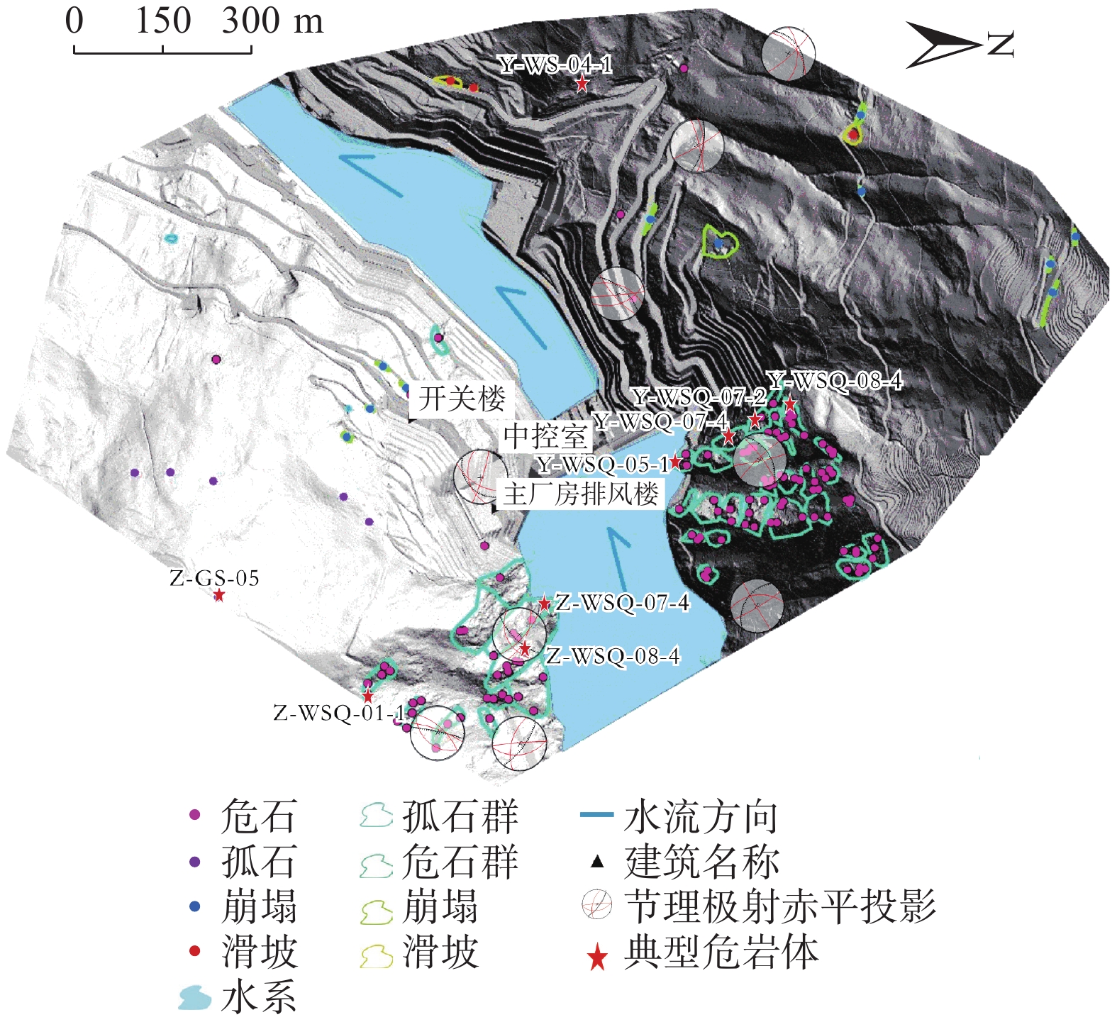
结合室内遥感解译和野外复核调查结果,研究区内危岩体以孤石、孤石群、危石、危石群为主,本次共调查危岩体172处(包括危石及孤石132处、危石群及孤石群40处)崩塌11处以及滑坡3处(图2)。研究区内危岩体的命名以电站的左右岸坡为分界线,以不同危岩体分类的中文缩写作为其具体编号,如Y-WSQ07-2意为:右岸边坡07号危石群02岩块。
![]() 图 2 水电站研究区灾害分布图Figure 2. Geological background and hazard distribution map of the hydropower station survey area
图 2 水电站研究区灾害分布图Figure 2. Geological background and hazard distribution map of the hydropower station survey area研究区左岸自然边坡目前共分布危岩体58处以及崩塌4处,其中大部分危岩体位于枢纽区上游处,左岸边坡高峻陡峭,人类活动较少。从危岩体的规模上看,发育的危岩体12处属大型危岩体(1000 m3≤V<10000 m3)、13处为中型危岩体(100 m3≤V<1000 m3)、33处属于小型危岩体(V<100 m3)。
研究区右岸自然边坡目前共分布危岩体114处、滑坡3处以及崩塌7处,其中大部分危岩体位于枢纽区上游处,右岸边坡高峻陡峭,人类活动较少。从危岩体的规模上看,发育的危岩体26处属大型危岩体(1000 m3≤V<10000 m3)、17处为中型危岩体(100 m3≤V<1000 m3)、71处属于小型危岩体(V<100 m3)。
2.2 危岩体结构面产状
产状是表征结构面的空间展布状态,对于地质体中的结构面而言,首先它是一个面,一定空间范围内通常可以近似认为结构面是一个平面。
因此,在无人机摄影获取的三维模型数据中通过辨识结构面的出露面(图3),选择出露面上的尽可能多的点,基于Earth Survey软件平台来描述这些结构面的产状信息。最终实现了快速、准确地获取扫描地质体中结构面的产状参数,获取的危岩体结构面产状参数在三维运动过程模拟中,起着关键性的作用。
调查发现研究区内主要发育3组优势结构面,其中1组倾向近N,产状为345°~15°∠70°~85°,另外2组产状约260°~285°∠60°~80°、140°~180°∠50°~84°。其中,右岸主要发育345°~15°∠70°~85°和260°~285°∠60°~80°两组结构面;左岸边坡主要发育345°~15°∠70°~85°结构面。
2.3 危岩体空间几何特征
研究区危岩体空间几何特征的调查办法首先室内基于无人机遥感影像,在三维实景模型(图4)中识别危岩体,获取危岩体海拔、坐标、所处坡面坡度和几何形状参数等,随后在此基础上,进行野外现场调查和验证(图5),对危岩体边界范围、结构面发育情况和植被覆盖情况等方面进行了补充和修正。调查获得的空间几何特征参数可以为数值模拟Unity3D中危岩体几何参数的选取提供可靠的依据。
2.4 危岩体失稳模式
由于分类角度、研究区域不同,危岩体失稳模式存在多种分类方案。本文对研究区内172处危岩体分别按《水电工程危岩体工程地质勘察与防治规程》进行分类,主要分为滑塌式、倾倒式、坠落式、孤石及孤石群4类(图6)。
![]() 图 6 研究区典型危岩体失稳案例Figure 6. Typical cases of destabilization of dangerous rock masses in the study area
图 6 研究区典型危岩体失稳案例Figure 6. Typical cases of destabilization of dangerous rock masses in the study area滑塌式危岩体Y-WSQ05-1危岩体见图6(a),区域呈矩形分布,所在边坡陡峭几近直立,坡面植被较稀疏,岩体除受构造结构面切割外次生卸荷裂隙发育较少,为整体块状结构,卸荷范围为8~13m;主要发育2组结构面,结构面J1: 162°∠84,结构面J2: 216°∠62°,受顺层结构面控制,主控制结构面倾向临空面。
倾倒式危岩体Z-WSQ08-4见图6(b),整体凸出于周围岩层,临空条件好,结构面张开度较大,岩体植被覆盖很少,基岩裸露,岩体除受构造结构面切割外发育部分卸荷裂隙,为块状结构,卸荷范围为14~18m;主要发育2组结构面,结构面J1: 69°∠84°;结构面J2: 296°∠78°。
坠落式危岩体Y-WSQ07-4见图6(c),危岩体块整体凸出于周围岩层,整体坡度较陡,接近直立,有明显的基岩裸露,下部临空,危岩体下部有新鲜掉块的痕迹,推测该失稳机理为在自重等因素影响下,下部岩块脱落,导致上部岩体应力重分布,主要靠与母岩的岩桥连接保持现有的稳定,再次失稳将由裂隙贯通造成
孤石及孤石群类型的危岩体Z-GS-05见图6(d),为已经剥离母岩的巨石块体嵌入于下方残破堆积物上层,底部松动,有向下滚动的优势临空面;岩体风化程度为中等风化,风化范围为5~8 m。发育部分卸荷裂隙,为块裂结构,卸荷范围为2~3 m。
3. 三维运动学模拟
3.1 模拟原理
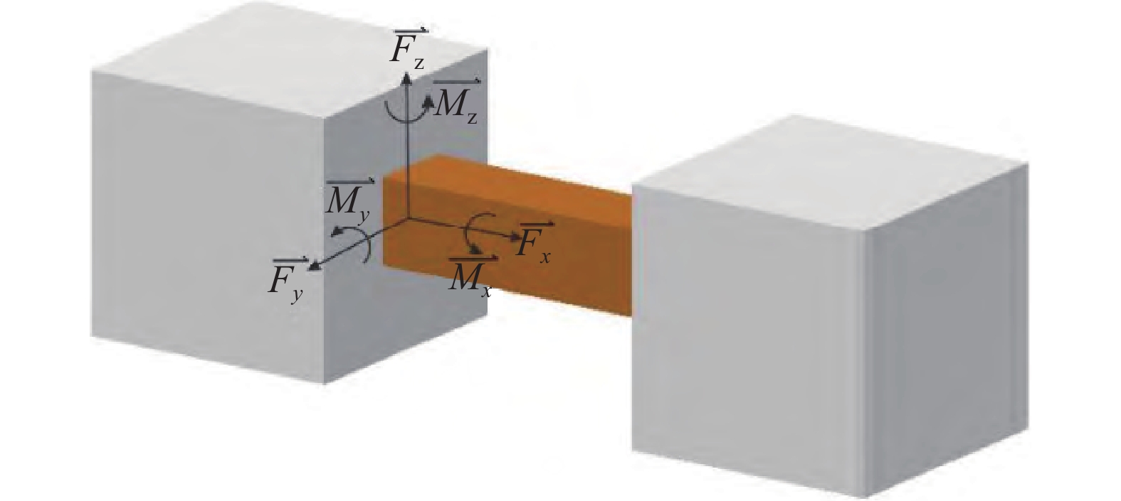
Unity3D软件以研究区内高精度三维实景数据和危岩体调查结果构成运动模拟的灾害实景(图7)。该软件在进行崩塌运动过程数值模拟时将岩块与坡体视为刚体,利用调整物理材料的参数的方法控制摩擦和恢复系数,有效处理了刚体间相互碰撞过程中的能量损失。同时通过使用引擎中一个称为“固定关节”的组件(图8)连接岩块对象[18],模拟出落石与坡体撞击碎裂及块体间相互撞击碎裂的过程。使得该软件实现了危岩体弹跳、滚动和滑动等物理效果的模拟,最终对数据进行分析处理得到落石运动全过程的运动特征参数。
![]() 图 8 固定关节示意图(M和F表示约束力矩和约束反力)Figure 8. Schematic diagram of the fixed joints (M and F represent the constraint torque and constraint reaction forces)
图 8 固定关节示意图(M和F表示约束力矩和约束反力)Figure 8. Schematic diagram of the fixed joints (M and F represent the constraint torque and constraint reaction forces)3.2 参数选择
危岩体精细模型的具体参数包括块体形状、尺寸、密度、结构面抗剪强度、动摩擦系数、静摩擦系数、弹跳系数。d1、d2和d3表示危岩体的尺寸,依据危岩带岩体结构面间距及历史落石块体尺寸特征选取[18]。坝址区发育危岩岩性多为变质火山角砾岩,综合区内过往岩石物理力学试验(表1)及工程类比方法,确定本次模拟的岩石密度取值为2.7 g/cm3。通过模拟实验进行坡面特征参数反演,确定动摩擦系数为0.3,静摩擦系数为0.3,弹跳系数为0.6。参数设置如表2所示。
表 1 坝址区室内岩石物理力学试验表Table 1. Rock physical and mechanical test data for dam site area岩石名称及风化程度 组数 抗压强度 静态变形试验 干抗压/MPa 湿抗压/MPa 软化系数 干 湿 弹性模量/GPa 泊松比 弹性模量/GPa 泊松比 变质火山角砾岩(弱−微) 11 95.9 72.8 0.76 68 0.17 59 0.19 表 2 危岩体特征参数设定Table 2. Parameters for hazardous rock mass characteristics特征参数 形状 d1/m d2/m d3/m 密度/(g·cm−3) 固定关节断裂力阈值/N 动摩擦系数 静摩擦系数 弹跳系数 取值 立方体 1.5~3 1.5~3 1.5~3 2.7 1000 0.3 0.3 0.6 3.3 运动模拟分区
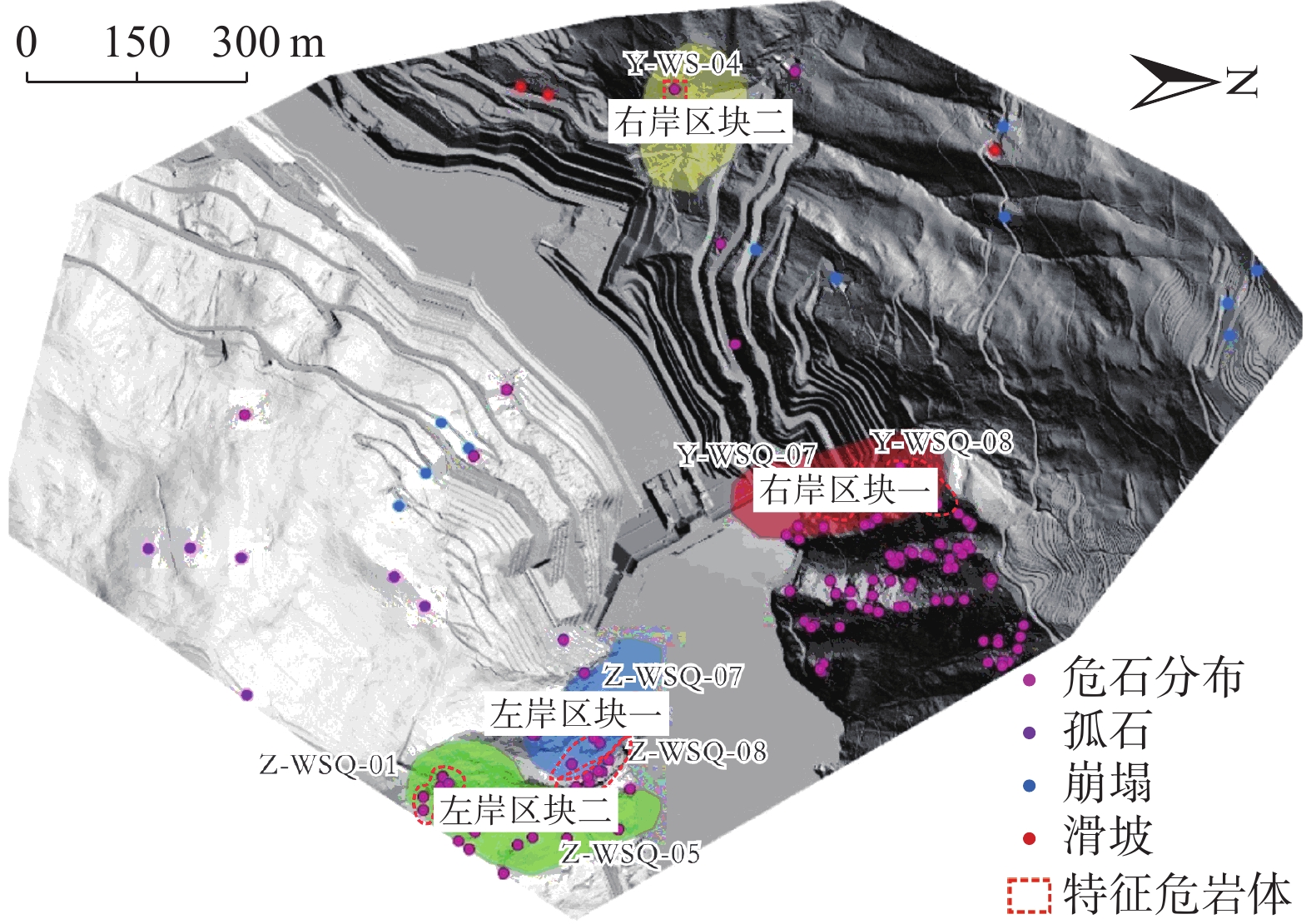
此次崩塌落石轨迹的数值模拟共分为4个区域,具体分布如图9所示。分区的原则主要是以危岩体出露的面为单位,大致将出露在同一坡面的危岩体划分为一个区域,该区域内危岩体通常沿着相同坡面滚落,或是在相同沟道中运动。以面为单位划分,对以下4个区域典型危岩体进行落石运动特征模拟,可为危岩体分区提供一定参考意义。
划分区块后,分析危岩体调查结果,选取各区块失稳模式较为典型、危险性较大的危岩体(表3)进行落石运动轨迹数值模拟。
表 3 水电站四区块危岩体分布特征表Table 3. Confidence statistics for investigating characteristic hazardous rock bodies in the study area危岩区块 特征岩块 平面坐标 出露高程/m 危岩体规模 易发性 风险性 承灾体 体积/m3 规模 右岸区块一 Y-WSQ07-4 (511578.5,2939142.2) 1 766.1 60.20 小 极高 极高 坝体 右岸区块二 Y-WS-04-1 (510800.5,2938995.6) 1 586.2 57.90 小 高 低 道路 左岸区块一 Z-WSQ07-4 (512040.6,2938637.2) 1 719.3 909.66 中 高 中 电站设施 左岸区块二 Z-WSQ01-1 (512584.5,2932301.3) 1 944.2 2.94 小 高 低 道路 3.4 落石运动特征分析
基于Unity3D集成物理引擎PhysX计算,真实再现了研究区4个区块的危岩体失稳滚落路径及解体形态,实时记录了运动轨迹及冲击动能参数。危岩解体过程如图10所示。
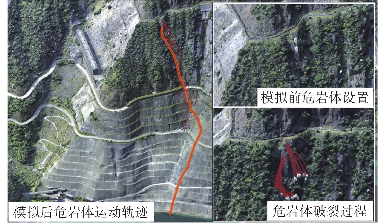
右岸区块一位于右岸坝体顶部自然边坡,两处典型危石群Y-WSQ07、Y-WSQ08模拟崩塌过程见图11(a)。右岸区块二位于右岸大坝下游交通要道急拐弯自然边坡,典型危岩体Y-WS-04危岩体,对Y-WS-04危岩体模拟崩塌过程见图11(b)。
![]() 图 11 右岸区块危岩体分布及运动路径Figure 11. Distribution and trajectory of hazardous rock masses in the right bank block
图 11 右岸区块危岩体分布及运动路径Figure 11. Distribution and trajectory of hazardous rock masses in the right bank block左岸危岩体落石模拟区块一位于左岸进水口顶部自然边坡,典型危岩体Z-WSQ-07、Z-WSQ-08所在坡面植被较稀疏,只有稀少灌木,模拟崩塌过程见图12(a)。左岸区块二位于左岸上游道路隧道口顶部自然边坡,其中典型危岩体Z-WSQ01、Z-WSQ-05所在坡面植被较稀疏,危岩群模拟崩塌过程见图12(b)。
![]() 图 12 左岸区块危岩体分布及运动路径Figure 12. Distribution and trajectory of hazardous rock masses in the left bank block
图 12 左岸区块危岩体分布及运动路径Figure 12. Distribution and trajectory of hazardous rock masses in the left bank block4个区块发育的危岩体解体后的特征岩块在最优路径下的运动结果如图13和表4所示。
![]() 图 13 危岩区落石运动模拟结果Figure 13. Simulation results of rockfall movement in hazardous rock area表 4 水电站四区块危岩体运动模拟结果Table 4. Simulation results of hazardous rock mass motion in area four, Huangdengshui hydropower station
图 13 危岩区落石运动模拟结果Figure 13. Simulation results of rockfall movement in hazardous rock area表 4 水电站四区块危岩体运动模拟结果Table 4. Simulation results of hazardous rock mass motion in area four, Huangdengshui hydropower station危岩区块 特征岩块 弹跳高度/m 冲击动能/kJ 距物源点的
平面距离/m威胁对象 范围值 最大值 范围值 最大值 右岸区块一 Y-WSQ07-4 0.5~7.92 7.92 2000~13700 13700 146 大坝及场内人员 右岸区块二 Y-WS-04-1 1~6 6 4000~16000 16000 122 公路、行人及车辆 左岸区块一 Z-WSQ07-4 0.8~9.2 9.02 35000~45000 45000 83 电站设施 左岸区块二 Z-WSQ01-1 1~14.6 14.6 4000~30000 30000 379 公路、行人及车辆 从运动模式来看,危岩体失稳后的首先表现均为重力作用下的自由落体运动,在撞击在下部裸露岩体后,与坡面接触碰撞后发生弹跳。发生第一次弹跳后,4个区块的落石运动开始出现巨大的差异,证明影响落石运动的因素众多。
右岸区块一由于坡度较陡,多数落石下落后又与坡面碰撞发生了2次碰撞弹跳后到达大坝开口线内,部分岩块在下落到一定高度之后,受到坡体稳定岩块和植被因素的影响,将会停积在坡面或者掉入库区水中,对坝体及附属建筑物影响小,其中Y-WSQ07-4号岩块由于所在坡面坡度较陡,发生滚动后将会快速下落,下落速度较高,动能较大,在混凝土护坡面多次发生弹跳,最终滚落到大坝右岸停止,对大坝和厂内工作人员存在较大安全隐患,动力学参数如图13(a)所示。
右岸区块二部分落石将会停积在坡面,但由于坡面植被局部密集,落石下落轨迹会发生转变,如Y-WS-04-1号岩块,发生滚动后将会沿着公路护坡滚动到道路上,沿着路面滚动一段距离,在摩擦力的作用下最终停止,对下方公路以及行人、车辆安全性具有一定的威胁,动力学参数如图13(b)所示。
左岸区块一发育的危岩群大部分岩块下落后又与坡面碰撞发生了二次碰撞弹跳后将落入水库蓄水区。但该区块发育的危岩体体积巨大,裂隙贯穿发育,稳定性差,虽然布置了防护网,但边缘处任有石块露出,若失稳,将对正下方设施有较大威胁,解体后的Z-WSQ07-4号岩块动力学参数如图13(c)所示。
左岸区块二多数危岩体在与坡面接触碰撞后发生弹跳,多次弹跳后落到路面上,在路面再发生高度较低的碰撞弹跳后,沿着路面滚动一段距离,在地表摩擦力的作用下最终停止。其中Z-WSQ01-1号岩块为对下方公路以及行人、车辆安全性具有一定的威胁,动力学参数如图13(d)所示。
4. 结论及建议
(1)通过无人机倾斜摄影测量及机载LiDAR遥感调查技术,开展研究区危岩体遥感解译及野外现场调查工作,基本查明了水电站两岸自然边坡危岩体发育分布、岩体产状特征,空间姿态等情况,经现场复核发现危岩体特征基本符合室内无人机三维实景模型解译的结果。
(2)与传统三维落石模拟软件相比,Unity3D软件具备可视化灾害信息的特点,使得整个危岩体崩塌运动过程更加直观,并且获得的模拟结果与现场调查落石崩落范围较吻合,证明此次运动反演分析的可靠性。
(3)研究区内现有防护治理措施总体布置合理完善,针对性强。区内右侧岸坡已设置多级被动防护网,坡上发育的危岩体不会对电厂内重要设施构成威胁,无需增加防护设计。左岸存在多处电站重要设施,需对左岸进水口上方边坡局部危岩增设2处APS-200主动防护网(图14),防护网面积约550 m2;对支护边坡马道边危岩体采取喷射混凝土治理措施,面积约52 m2,并且加强对500 kV开关站上方自然边坡的形变监测,提升防护性能。
-
![]()
图 2 水电站研究区灾害分布图
Figure 2. Geological background and hazard distribution map of the hydropower station survey area
![]()
图 6 研究区典型危岩体失稳案例
Figure 6. Typical cases of destabilization of dangerous rock masses in the study area
![]()
图 8 固定关节示意图(M和F表示约束力矩和约束反力)
Figure 8. Schematic diagram of the fixed joints (M and F represent the constraint torque and constraint reaction forces)
![]()
图 11 右岸区块危岩体分布及运动路径
Figure 11. Distribution and trajectory of hazardous rock masses in the right bank block
![]()
图 12 左岸区块危岩体分布及运动路径
Figure 12. Distribution and trajectory of hazardous rock masses in the left bank block
![]()
图 13 危岩区落石运动模拟结果
Figure 13. Simulation results of rockfall movement in hazardous rock area
表 1 坝址区室内岩石物理力学试验表
Table 1 Rock physical and mechanical test data for dam site area
岩石名称及风化程度 组数 抗压强度 静态变形试验 干抗压/MPa 湿抗压/MPa 软化系数 干 湿 弹性模量/GPa 泊松比 弹性模量/GPa 泊松比 变质火山角砾岩(弱−微) 11 95.9 72.8 0.76 68 0.17 59 0.19  下载: 导出CSV
表 2 危岩体特征参数设定
Table 2 Parameters for hazardous rock mass characteristics
特征参数 形状 d1/m d2/m d3/m 密度/(g·cm−3) 固定关节断裂力阈值/N 动摩擦系数 静摩擦系数 弹跳系数 取值 立方体 1.5~3 1.5~3 1.5~3 2.7 1000 0.3 0.3 0.6
下载: 导出CSV
表 3 水电站四区块危岩体分布特征表
Table 3 Confidence statistics for investigating characteristic hazardous rock bodies in the study area
危岩区块 特征岩块 平面坐标 出露高程/m 危岩体规模 易发性 风险性 承灾体 体积/m3 规模 右岸区块一 Y-WSQ07-4 (511578.5,2939142.2) 1 766.1 60.20 小 极高 极高 坝体 右岸区块二 Y-WS-04-1 (510800.5,2938995.6) 1 586.2 57.90 小 高 低 道路 左岸区块一 Z-WSQ07-4 (512040.6,2938637.2) 1 719.3 909.66 中 高 中 电站设施 左岸区块二 Z-WSQ01-1 (512584.5,2932301.3) 1 944.2 2.94 小 高 低 道路
下载: 导出CSV
表 4 水电站四区块危岩体运动模拟结果
Table 4 Simulation results of hazardous rock mass motion in area four, Huangdengshui hydropower station
危岩区块 特征岩块 弹跳高度/m 冲击动能/kJ 距物源点的
平面距离/m威胁对象 范围值 最大值 范围值 最大值 右岸区块一 Y-WSQ07-4 0.5~7.92 7.92 2000~13700 13700 146 大坝及场内人员 右岸区块二 Y-WS-04-1 1~6 6 4000~16000 16000 122 公路、行人及车辆 左岸区块一 Z-WSQ07-4 0.8~9.2 9.02 35000~45000 45000 83 电站设施 左岸区块二 Z-WSQ01-1 1~14.6 14.6 4000~30000 30000 379 公路、行人及车辆
下载: 导出CSV
-
[1] 黄海宁,黄健,周春宏,等. 无人机影像在高陡边坡危岩体调查中的应用[J]. 水文地质工程地质,2019,46(6):149 − 155. [HUANG Haining,HUANG Jian,ZHOU Chunhong,et al. Application of UAV images to rockfall investigation at the high and steep slope[J]. Hydrogeology & Engineering Geology,2019,46(6):149 − 155. (in Chinese with English abstract) HUANG Haining, HUANG Jian, ZHOU Chunhong, et al . Application of UAV images to rockfall investigation at the high and steep slope[J]. Hydrogeology & Engineering Geology,2019 ,46 (6 ):149 −155 . (in Chinese with English abstract)[2] 陈爱云,曾唯恐,王哲,等. 基于三维激光扫描技术的危岩体特征快速识别方法及稳定性评价[J]. 水利与建筑工程学报,2019,17(6):60 − 64. [CHEN Aiyun,ZENG Weikong,WANG Zhe,et al. Application of unstable rock investigation and stability evaluation based on 3D laser scanning technology[J]. Journal of Water Resources and Architectural Engineering,2019,17(6):60 − 64. (in Chinese with English abstract) CHEN Aiyun, ZENG Weikong, WANG Zhe, et al . Application of unstable rock investigation and stability evaluation based on 3D laser scanning technology[J]. Journal of Water Resources and Architectural Engineering,2019 ,17 (6 ):60 −64 . (in Chinese with English abstract)[3] 崔溦,谢恩发,张贵科,等. 利用无人机技术的高陡边坡孤立危岩体识别[J]. 武汉大学学报(信息科学版),2021,46(6):836 − 843. [CUI Wei,XIE Enfa,ZHANG Guike,et al. Identification of isolated dangerous rock mass in high and steep slope using unmanned aerial vehicle[J]. Geomatics and Information Science of Wuhan University,2021,46(6):836 − 843. (in Chinese with English abstract) CUI Wei, XIE Enfa, ZHANG Guike, et al . Identification of isolated dangerous rock mass in high and steep slope using unmanned aerial vehicle[J]. Geomatics and Information Science of Wuhan University,2021 ,46 (6 ):836 −843 . (in Chinese with English abstract)[4] 褚宏亮,殷跃平,曹峰,等. 大型崩滑灾害变形三维激光扫描监测技术研究[J]. 水文地质工程地质,2015,42(3):128 − 134. [CHU Hongliang,YIN Yueping,CAO Feng,et al. Research on deformation monitoring of large collapses and landslides based on 3D laser scanning technology[J]. Hydrogeology & Engineering Geology,2015,42(3):128 − 134. (in Chinese with English abstract) CHU Hongliang, YIN Yueping, CAO Feng, et al . Research on deformation monitoring of large collapses and landslides based on 3D laser scanning technology[J]. Hydrogeology & Engineering Geology,2015 ,42 (3 ):128 −134 . (in Chinese with English abstract)[5] 黄润秋,刘卫华,周江平,等. 滚石运动特征试验研究[J]. 岩土工程学报,2007,29(9):1296 − 1302. [HUANG Runqiu,LIU Weihua,ZHOU Jiangping,et al. Rolling tests on movement characteristics of rock blocks[J]. Chinese Journal of Geotechnical Engineering,2007,29(9):1296 − 1302. (in Chinese with English abstract) HUANG Runqiu, LIU Weihua, ZHOU Jiangping, et al . Rolling tests on movement characteristics of rock blocks[J]. Chinese Journal of Geotechnical Engineering,2007 ,29 (9 ):1296 −1302 . (in Chinese with English abstract)[6] 陈宙翔,叶咸,张文波,等. 基于无人机倾斜摄影的强震区公路高位危岩崩塌形成机制及稳定性评价[J]. 地震工程学报,2019,41(1):257 − 267. [CHEN Zhouxiang,YE Xian,ZHANG Wenbo,et al. Formation mechanism analysis and stability evaluation of dangerous rock collapses based on the oblique photography by unmanned aerial vehicles[J]. China Earthquake Engineering Journal,2019,41(1):257 − 267. (in Chinese with English abstract) CHEN Zhouxiang, YE Xian, ZHANG Wenbo, et al . Formation mechanism analysis and stability evaluation of dangerous rock collapses based on the oblique photography by unmanned aerial vehicles[J]. China Earthquake Engineering Journal,2019 ,41 (1 ):257 −267 . (in Chinese with English abstract)[7] 谢金,杨根兰,覃乙根,等. 基于无人机与Rockfall的危岩体结构特征识别与运动规律模拟[J]. 河南理工大学学报(自然科学版),2021,40(1):55 − 64. [XIE Jin,YANG Genlan,QIN Yigen,et al. Structural feature recognition and motion law simulation of dangerous rock mass based on UAV and Rockfall[J]. Journal of Henan Polytechnic University (Natural Science),2021,40(1):55 − 64. (in Chinese with English abstract) XIE Jin, YANG Genlan, QIN Yigen, et al . Structural feature recognition and motion law simulation of dangerous rock mass based on UAV and Rockfall[J]. Journal of Henan Polytechnic University (Natural Science),2021 ,40 (1 ):55 −64 . (in Chinese with English abstract)[8] 王栋,王剑锋,李天斌,等. 西南山区某铁路隧道口高位落石三维运动特征分析[J]. 地质力学学报,2021,27(1):96 − 104. [WANG Dong,WANG Jianfeng,LI Tianbin,et al. Analysis of three-dimensional movement characteristics of rockfall:A case study at a railway tunnel entrance in the southwestern mountainous area,China[J]. Journal of Geomechanics,2021,27(1):96 − 104. (in Chinese with English abstract) DOI: 10.12090/j.issn.1006-6616.2021.27.01.010 WANG Dong, WANG Jianfeng, LI Tianbin, et al . Analysis of three-dimensional movement characteristics of rockfall: A case study at a railway tunnel entrance in the southwestern mountainous area, China[J]. Journal of Geomechanics,2021 ,27 (1 ):96 −104 . (in Chinese with English abstract) DOI: 10.12090/j.issn.1006-6616.2021.27.01.010[9] 周月智,刘红岩,李俊峰,等. 地震荷载下危岩运动特征的模拟研究[J]. 工程地质学报,2021,29(5):1387 − 1400. [ZHOU Yuezhi,LIU Hongyan,LI Junfeng,et al. A study on motion characteristics of rockfall under seismic loadings by DDA[J]. Journal of Engineering Geology,2021,29(5):1387 − 1400. (in Chinese with English abstract) ZHOU Yuezhi, LIU Hongyan, LI Junfeng, et al . A study on motion characteristics of rockfall under seismic loadings by DDA[J]. Journal of Engineering Geology,2021 ,29 (5 ):1387 −1400 . (in Chinese with English abstract)[10] 黎尤,何坤,胡卸文,等. 震裂山体崩塌形成特征及运动学三维模拟——以汶川县三官庙村崩塌为例[J]. 工程地质学报,2022,30(2):542 − 552. [LI You,HE Kun,HU Xiewen,et al. Formation characteristics and kinematics 3D simulation of rockfall evolved from shattered mountain:Case study of Sanguanmiao Village rockfall in Wenchuan County[J]. Journal of Engineering Geology,2022,30(2):542 − 552. (in Chinese with English abstract) LI You, HE Kun, HU Xiewen, et al . Formation characteristics and kinematics 3D simulation of rockfall evolved from shattered mountain: Case study of Sanguanmiao Village rockfall in Wenchuan County[J]. Journal of Engineering Geology,2022 ,30 (2 ):542 −552 . (in Chinese with English abstract)[11] 柳万里,晏鄂川,魏鹏飞,等. 落石运动特征试验及影响因素敏感性分析[J]. 山地学报,2021,39(1):47 − 58. [LIU Wanli,YAN Echuan,WEI Pengfei,et al. Experimental study on rockfall and sensitivity analysis of influencing factors[J]. Mountain Research,2021,39(1):47 − 58. (in Chinese with English abstract) LIU Wanli, YAN Echuan, WEI Pengfei, et al . Experimental study on rockfall and sensitivity analysis of influencing factors[J]. Mountain Research,2021 ,39 (1 ):47 −58 . (in Chinese with English abstract)[12] 赵兴权,张迎宾,陈光齐,等. 非连续变形分析方法及其在灾害防治研究中的应用[J]. 西南交通大学学报,2016,51(2):300 − 312. [ZHAO Xingquan,ZHANG Yingbin,CHEN Guangqi,et al. Discontinuous deformation analysis method and its applications to disaster prevention[J]. Journal of Southwest Jiaotong University,2016,51(2):300 − 312. (in Chinese with English abstract) ZHAO Xingquan, ZHANG Yingbin, CHEN Guangqi, et al . Discontinuous deformation analysis method and its applications to disaster prevention[J]. Journal of Southwest Jiaotong University,2016 ,51 (2 ):300 −312 . (in Chinese with English abstract)[13] 黄小福,张迎宾,赵兴权,等. 地震条件下危岩崩塌运动特性的初步探讨[J]. 岩土力学,2017,38(2):583 − 592. [HUANG Xiaofu,ZHANG Yingbin,ZHAO Xingquan,et al. A preliminary study of kinetic characteristic of rock-fall under seismic loading[J]. Rock and Soil Mechanics,2017,38(2):583 − 592. (in Chinese with English abstract) HUANG Xiaofu, ZHANG Yingbin, ZHAO Xingquan, et al . A preliminary study of kinetic characteristic of rock-fall under seismic loading[J]. Rock and Soil Mechanics,2017 ,38 (2 ):583 −592 . (in Chinese with English abstract)[14] 刘国阳,孟海怡,宁宝宽,等. 基于三维非连续变形分析的巨石崩塌运动研究[J]. 岩土力学,2022,43(1):246 − 256. [LIU Guoyang,MENG Haiyi,NING Baokuan,et al. Study on collapse and movement of a boulder based on 3D discontinuous deformation analysis[J]. Rock and Soil Mechanics,2022,43(1):246 − 256. (in Chinese with English abstract) LIU Guoyang, MENG Haiyi, NING Baokuan, et al . Study on collapse and movement of a boulder based on 3D discontinuous deformation analysis[J]. Rock and Soil Mechanics,2022 ,43 (1 ):246 −256 . (in Chinese with English abstract)[15] 王军义,梁风,彭雄武,等. 基于GIS技术的单体崩塌危险范围评价方法研究[J]. 工程地质学报,2023,31(1):188 − 198. [WANG Junyi,LIANG Feng,PENG Xiongwu,et al. Study on assessment method of single collapse risk range based on GIS technology[J]. Journal of Engineering Geology,2023,31(1):188 − 198. (in Chinese with English abstract) WANG Junyi, LIANG Feng, PENG Xiongwu, et al . Study on assessment method of single collapse risk range based on GIS technology[J]. Journal of Engineering Geology,2023 ,31 (1 ):188 −198 . (in Chinese with English abstract)[16] 孙敬辉,石豫川. 重庆甑子岩崩塌落石动力学特征及危险性分区[J]. 中国地质灾害与防治学报,2019,30(3):6 − 11. [SUN Jinghui,SHI Yuchuan. Dynamics and hazard zoning of collapse and rockfall in Zengziyan,Chongqing[J]. The Chinese Journal of Geological Hazard and Control,2019,30(3):6 − 11. (in Chinese with English abstract) SUN Jinghui, SHI Yuchuan . Dynamics and hazard zoning of collapse and rockfall in Zengziyan, Chongqing[J]. The Chinese Journal of Geological Hazard and Control,2019 ,30 (3 ):6 −11 . (in Chinese with English abstract)[17] 何宇航,裴向军,梁靖,等. 基于Rockfall的危岩体危险范围预测及风险评价——以九寨沟景区悬沟危岩体为例[J]. 中国地质灾害与防治学报,2020,31(4):24 − 33. [HE Yuhang,PEI Xiangjun,LIANG Jing,et al. Risk assessment and range prediction of dangerous rockmass based on rockfall:A case study of the Xuangou Collapse[J]. The Chinese Journal of Geological Hazard and Control,2020,31(4):24 − 33. (in Chinese with English abstract) HE Yuhang, PEI Xiangjun, LIANG Jing, et al . Risk assessment and range prediction of dangerous rockmass based on rockfall: A case study of the Xuangou Collapse[J]. The Chinese Journal of Geological Hazard and Control,2020 ,31 (4 ):24 −33 . (in Chinese with English abstract)[18] 王豪,黄健,黄祥,等. 一种利用Unity3D模拟崩塌三维运动全过程的方法[J/OL]. 武汉大学学报(信息科学版):1 − 10[2022-04-27]. [WANG Hao,HUANG Jian,HUANG Xiang,et al. A method to simulate the whole process of collapse 3D motion using Unity3D[J/OL]. Journal of Wuhan University (Information Science Edition):1 − 10 [2022-04-27]. (in Chinese with English abstract) WANG Hao, HUANG Jian, HUANG Xiang, et al. A method to simulate the whole process of collapse 3D motion using Unity3D[J/OL]. Journal of Wuhan University (Information Science Edition): 1 − 10 [2022-04-27]. (in Chinese with English abstract)
[19] 夏雄彬,谯立家,许万忠. 基于机载LiDAR及无人机影像的高位危岩体调查和成因分析[J]. 长江科学院院报,2023,40(9):188 − 194. [XIA Xiongbin,QIAO Lijia,XU Wanzhong. Investigation and cause analysis of dangerous rock masses on high and steep slope based on airborne LiDAR and UAV imagery[J]. Journal of Changjiang River Scientific Research Institute,2023,40(9):188 − 194. (in Chinese with English abstract) XIA Xiongbin, QIAO Lijia, XU Wanzhong . Investigation and cause analysis of dangerous rock masses on high and steep slope based on airborne LiDAR and UAV imagery[J]. Journal of Changjiang River Scientific Research Institute,2023 ,40 (9 ):188 −194 . (in Chinese with English abstract) -
期刊类型引用(8)
1. 涂正楠,冯君,邓应进,潘激扬. 四川甘洛县比依市村滑坡运动特征分析. 中国地质灾害与防治学报. 2024(01): 92-99 .  本站查看
本站查看
2. 程雨柯,李亚虎,夏金梧,侯赠,陈娜. 无人机技术在超高陡边坡危岩体半自动识别中的应用. 中国地质灾害与防治学报. 2024(01): 143-154 . 本站查看
3. 陈宇,沈位刚,宋忠友,高攀,鄢发斌,雍平,张锐. 土垫层缓冲落石冲击力特性离散元数值模拟分析. 中国地质灾害与防治学报. 2024(02): 90-97 . 本站查看
4. 臧佳园,常文斌,邢爱国,张耀明,王春玲,金凯平,沈凌铠,于文罡. 含构造节理的崩塌体动力破碎特征. 中国地质灾害与防治学报. 2024(03): 1-11 . 本站查看
5. 王风鹏. 无人机激光雷达技术在陡峭山区作业中的应用研究. 工程技术研究. 2024(10): 219-221 . 百度学术
6. 卢树盛,向能武,孙云志. 高边坡勘察新技术在水利工程中的应用现状、挑战与展望. 中国水利. 2024(14): 44-50 . 百度学术
7. 宗朝正,吉锋,陈利鑫. 基于Rockfall Analyst的滚石运动参数反演及三维轨迹分析. 地质灾害与环境保护. 2024(04): 1-5 . 百度学术
8. 李文龙. 机载LiDAR技术在广州黄埔区地质灾害调查中的应用. 中国地质灾害与防治学报. 2024(06): 164-172 . 本站查看
其他类型引用(0)


计量
- 文章访问数: 3690
- HTML全文浏览量: 2248
- PDF下载量: 159
- 被引次数: 8
 邮件订阅
邮件订阅 RSS
RSS